Looking towards the Cheviot from the eastern outcrop.
Image credit: A. Brookes (12.3.2019)
Looking towards the Cheviot from the eastern outcrop.

One of the smaller cup and rings on the eastern outcrop.

Looking east towards Goatscrag (in shadow) from the western outcrop.

Tight grouping of cupmarks on the western outcrop.

Carvings on the western outcrop.

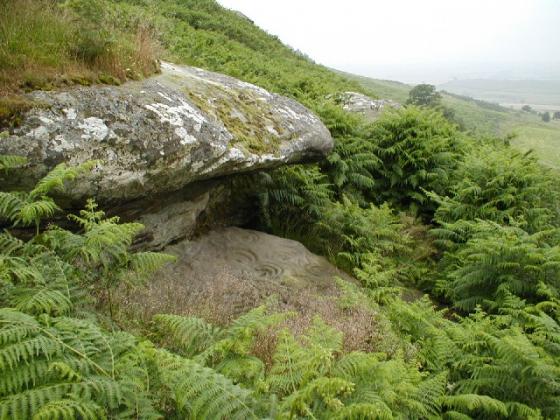
Western outcrop, looking towards the Cheviot.


(After Beckensall, 2001)

Panel 2

Panel 2

Panel 2

Panel 2

Panel 1

Panel 1

From ‘Incised Markings on Stone’, 1869

1-12-06 panel 2
wolfy

1-12-06 panel 2
wolfy

1-12-06 panel 2
wolfy

1-12-06 panel 2
wolfy

1-12-06 panel 1
the rain storm heading our way
wolfy

1-12-06 panel 1
wolfy

Taken 23-2-2003. The more westerly outcrop, actual position NT971371.
A strange circular shape, appears to have been cut rather than natural.
Angular marks on the side of it too? About 3 feet in diameter.
((O))

Taken 23-2-2003. The more westerly outcrop, actual position NT971371.
((O))

Taken 23-2-2003. The more westerly outcrop, actual position NT971371.
Cheviot behind the mist.
((O))

Taken 23-2-2003. Near the more easterly outcrop, actual position NT973373. I’m sure this is a burial cairn of some sort.

Taken 23-2-2003. The more easterly outcrop, actual position NT973372.
((O))

Taken 23-2-2003. The more easterly outcrop, actual position NT973372.
View to the south, with Doddington Moor to the left and The Cheviot to the right (behind the mist!)
((O))

Taken 23-2-2003. The more easterly outcrop, actual position NT973372.
Cut through by a line of more weather-resistant quartz.
((O))

Taken 23-2-2003. The more easterly outcrop, actual position NT973372. One of the largest carvings I’ve seen, boot for scale:-)
((O))

View to the east over the Broomridge-2 rock art panel to the Goatscrag. August 1998.

Cups, some unusual shaped, at Broomridge-2 rock art site. August 1998.
Nice views of Cheviot, and before the trees, it would have been probably intervisible with Roughting Linn. Good access (we managed to get a 3 wheeler buggy up there, but a wheelchair wouldn’t work) with public footpaths making it quite easy to get to from Roughting Linn, via Goatscrag.
The outcrops known as 1 and 2 are fairly easy to spot if the bracken isn’t too high. I didn’t get to panel 3, but there is only one conspicuous outcrop in the right area, so it’s probably not too tricky either. In direct mid-day sun, the motifs of both 1 and 2 are almost invisible. I’d say anyone wanting to see the carvings would be well advised to time their visit to early morning or late evening, preferably earlier in the year when the bracken won’t be a problem.
The carvings are quite eroded, and I found it tricky to reconcile what I saw with the complexity of the drawings by Beckensall, Tate and Bruce.
I was up here recently with the rockartuk fellas on their RAM04. I’ve been here before but could never find the ‘deer carvings’. Nay problems this time, Jan and Gus took us straight to them. Well, what actually happened was, Jan went to the farmhouse took ask permission to scramble on the crag and Gus went off in search of an owl’s nest. But we got there in the end.
It’s well worth the climb to see these lovely carvings, they are quite worn and there is some debate about their antiquity but bearing in mind that when this rock overhang was excavated it yeilded flints and burials, plus the fact that the top of the overhand is decorated with carvings and that the whole site looks down over the Routing Linn complex of carved rock, enclosure, cave and waterfall, I would say that the circumstantial evidence for these carvings being ancient is pretty strong.
After checking out the carvings we moved up onto the moor. There are some nice carvings up here including the ‘horseshoe carvings on the top of the overhang. We also came across a couple of carvings made by the fellas trying to extract millstones.
If you are visiting Routing Linn I would recommend that you take an extra hour or so to check out this area. There is lots to find and the views are crackin’. It will also give you an idea of the intervisibility theories between the various sites along the Millfield Plain and Till Valley.
23-2-2003.
Followed the track up through Routin Linn farm, and it’s on the hill to the west of the crags. The paths are well-used by horse riders so access is relatively easy. There are two outcrops marked on the map, NT973372 and NT971371.
They are worth the trip up, I loved this site!
To the Goatscrags end of the hill, there is a sheltered quarry-type area, which I am sure has a hollow next to it as if it’s been a burial mound there. Lots of geographical reasons why this could be the case?
.o0O0o.
“The next site (Broomridge) shares a dome of outcrop rock that has ben
used for producing millstones, so don’t confuse these big circles with the low profile clusters of cups and the eroded multiple concentric circles around a cup at the east end of the rock”.
From Stan Beckensall’s’Prehistoric Rock Motifs of Northumberland.
Volume 1 Ford to Old Bewick published in 1991.
The Abbey Press, Hexam
Broomridge on BRAC Updated