The Modern Antiquarian
Log in
|
Register
Home
Latest Posts
Forums
Maps
Help
Browse Sites
News
Blog
Contributors
The Books
Select
-
Belgium
Denmark
Eire
France
Germany
Greece
Italy
The Netherlands
Norway
Portugal
Republic of Malta
Spain
Sweden
Switzerland
United Kingdom
England
Southern England
Devon
Exmoor (Devon)
Brendon Two Gates (W)
Stone Row / Alignment
Brendon Two Gates (W) (Stone Row / Alignment) on The Modern Antiquarian, the UK & Ireland's most popular megalithic community website. 3 images, plus information on many more ancient sites nearby and across the UK & Ireland.
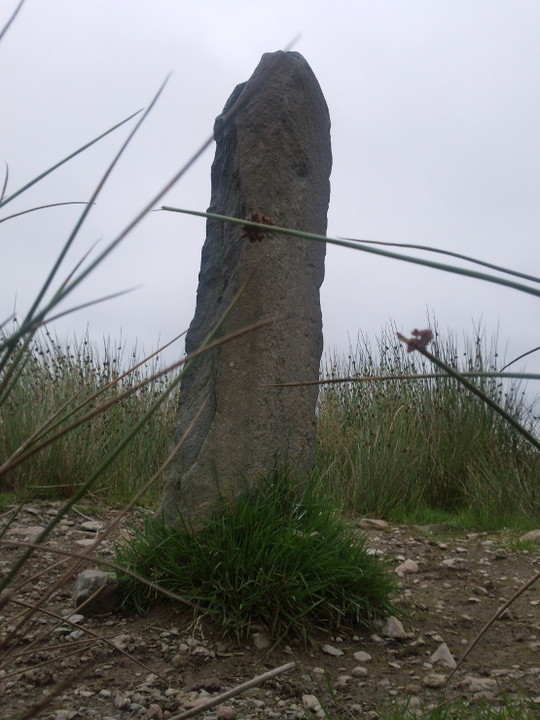
Image © juamei
Nearest Town:
Lynton (7km NW)
OS Ref (GB):
SS76604364 /
Sheet: 180
Latitude:
51° 10' 41.14" N
Longitude:
3° 45' 56.13" W
Added by
juamei
Images (3)
0 discussions
Start a topic
Show |
Hide
Web searches for Brendon Two Gates (W)
Flickr
Google
Google Images
MAGIC
The Megalithic Portal
Bing
Stone Pages
Streetmap.co.uk
Wikipedia
Show map
(inline Google Map)
- Sites within 20 km -
-
Hoccombe Hill West (0.47km ENE) (3 posts)
Clannon Ball Stone Setting (0.7km WSW) (3 posts)
Hoccombe Hill East (1.51km E) (4 posts)
Rexy Barrow (1.74km SE) (1 post)
Lanacombe stones (1.76km ESE) (1 post)
Lanacombe 4 (2.09km E) (1 post)
Badgworthy Lees Stone (2.39km ENE) (1 post)
Hoaroak (2.69km WSW) (1 post)
Manor Allotment stone setting (3.57km ENE) (1 post)
Chains Barrow (3.59km WSW) (1 post)
Longcombe Burrow (3.81km E) (1 post)
Swap Hill Stone (4.02km E) (1 post)
Stowey Allotment Stone (4.62km ENE) (1 post)
Ilkerton Ridge Stone (4.65km W) (1 post)
Woodbarrow (5.01km WSW) (2 posts)
Halscombe Stones (5.27km SSE) (1 post)
Lyn Long Stones (5.47km WNW) (2 posts)
Drybridge Combe Stone (5.55km S) (1 post)
Roman Lode (5.61km S) (1 post)
Ricksy Ball Stone (5.65km SSW) (1 post)
Elsworthy (5.95km E) (1 post)
Longstone Barrow (5.95km WSW) (3 posts)
Longstone Stone Setting (5.99km WSW) (1 post)
Lark Barrow (6.06km E) (1 post)
Squallacombe I, II and III (6.09km SSW) (3 posts)
The Longstone (Exmoor) (6.11km WSW) (9 posts)
Countisbury Castle (6.31km NW) (1 post)
Black Barrow (6.61km ENE) (1 post)
Horsen Hill Stones (6.74km SE) (1 post)
Setta Barrow (6.82km SW) (4 posts)
Cow Castle (6.83km SE) (8 posts)
Chapman Barrows (6.88km WSW) (3 posts)
Stone near Roe Barrow (7.09km W) (1 post)
Pixie Rocks (7.15km WSW) (1 post)
Alderman's Barrow (7.17km E) (4 posts)
High Bray no. 9 (7.19km SW) (1 post)
Quarter Barrow (7.27km ENE) (1 post)
Muxworthy Ridge (7.29km SSW) (6 posts)
Woolhanger Henge (7.48km W) (2 posts)
Shoulsbury Castle (7.51km SW) (6 posts)
Culbone Stone (7.53km ENE) (6 posts)
Culbone Hill (7.53km ENE) (7 posts)
Five Barrows (7.63km SSW) (11 posts)
Hangley Cleave (7.7km S) (6 posts)
Long Holcombe Stone (7.73km SSE) (1 post)
Porlock Stone Circle (7.84km ENE) (17 posts)
Almsworthy Stone Circle (8.01km E) (8 posts)
Porlock Stone Row (8.03km ENE) (4 posts)
Sherdon Barrows (8.56km SE) (2 posts)
Whit Stones (9.04km ENE) (7 posts)
The Wilmersham Common row (9.18km E) (1 post)
Bendels Barrows (9.19km E) (2 posts)
Paracombe Lane (9.26km W) (3 posts)
Berry Castle (9.35km ENE) (2 posts)
Hoar Moor Stone (9.92km E) (1 post)
Brightworthy Barrows (10.02km SE) (2 posts)
Tar Ball Hill Barrow (10.29km ENE) (1 post)
Broken Barrow (10.35km WSW) (2 posts)
Green Barrow (10.44km SE) (1 post)
Beacon Castle (10.47km W) (0 posts)
Rowbarrow ring barrow and a round cairn (11.01km E) (2 posts)
Rowbarrows (11.07km E) (3 posts)
Great Rowbarrow (11.1km E) (2 posts)
Portford Bridge Stone (11.14km ESE) (1 post)
Stoke Pero (11.37km E) (1 post)
Herne's Barrow (11.38km ESE) (2 posts)
Road Castle (11.39km E) (2 posts)
Voley Castle (11.42km W) (1 post)
Little Rowbarrow (11.42km E) (2 posts)
Withypool Hill Barrow (11.78km ESE) (1 post)
Withypool Stone Circle (11.85km ESE) (5 posts)
Twitchen Barrows (11.85km SE) (2 posts)
Dunkery Beacon (12.74km E) (16 posts)
Staddon Hill Camp (12.99km E) (2 posts)
Staddon Hill Barrows (13.43km E) (1 post)
Old Barrow (13.44km ESE) (1 post)
Kit Barrows (13.48km E) (1 post)
Dunkery Hill Barrows (14.19km E) (6 posts)
Wambarrows (14.39km ESE) (5 posts)
Bossington Hill (14.99km ENE) (8 posts)
Bury Castle (Selworthy) (15.51km ENE) (10 posts)
Devil's Stone (Luckwell Bridge) (15.58km E) (2 posts)
Caratacus Stone (15.84km ESE) (8 posts)
Selworthy Beacon (16.15km ENE) (10 posts)
Bremridge Wood (16.3km SSW) (0 posts)
Mattocks Down (16.44km WSW) (7 posts)
West Anstey Longstone (16.46km SE) (3 posts)
Hangman's Stone (Combe Martin) (16.66km W) (1 post)
Cunnilear Camp (16.72km WSW) (0 posts)
Furzebury Brake (17.56km ENE) (3 posts)
Periton Hill Barrows (18.15km ENE) (3 posts)
Mounsey Castle (18.44km ESE) (4 posts)
Anstey Barrow (18.47km ESE) (1 post)
Lype Hill (19.28km E) (4 posts)
Berrynarbor (19.72km WSW) (1 post)
- Add -
-
Add news
Add an image
Add fieldnotes
Add folklore
Add miscellaneous
Add a link
-
Add a site
Add a nearby facility
Add an alternative name/spelling
Images
(click to view fullsize)
Add an image
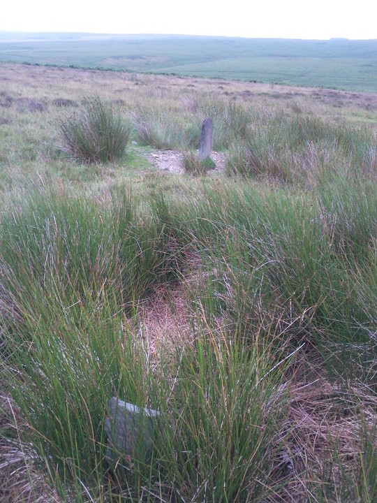
 Image © juamei