|
|

|
Exmoor (Devon): Latest Posts |
Showing 1-10 of 72 posts. Most recent first | Next 10 
Haytor Rock (Rocky Outcrop) — Images (click to view fullsize) |
|
 Posted by GLADMAN
29th July 2017ce |
Shoulsbury Castle (Hillfort) — Images |
|
 Posted by juamei
20th January 2016ce |
Woolhanger Henge — Images |

|
Posted by juamei 6th January 2016ce |
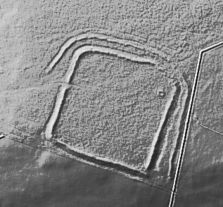
Woolhanger Henge — Miscellaneous |
|
http://www.pastscape.org.uk/hob.aspx?hob_id=34733 A large circular earthwork is visible on Parracombe Common consisting of a bank and internal ditch which has been interpreted as a henge or a disc barrow. The earthwork forms an enclosure measuring 40 metres in diameter with a bank 3.4 metres wide by 0.4 metres high. It has an internal ditch 0.3 metres deep, and has been bisected by a hedge bank. There was no visible evidence of an entrance during field investigation in 1993. The monument is clearly visible on aerial photographs taken in 1952, but by 1972 it has been severely damaged by ploughing and other agricultural activity. Too much of the monument has been either obscured or destroyed to allow the various claims as to the monument's nature to be evaluated purely on the basis of the surviving field evidence. On the aerial photographs from 1952, however, it most closely resembles a disc or saucer barrow. |
Posted by juamei 6th January 2016ce |
Longstone Barrow (Round Barrow(s)) — Images |

|
 Posted by tjj
3rd October 2015ce |
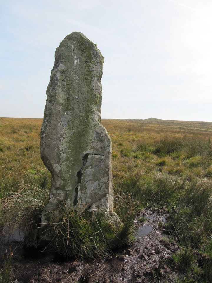
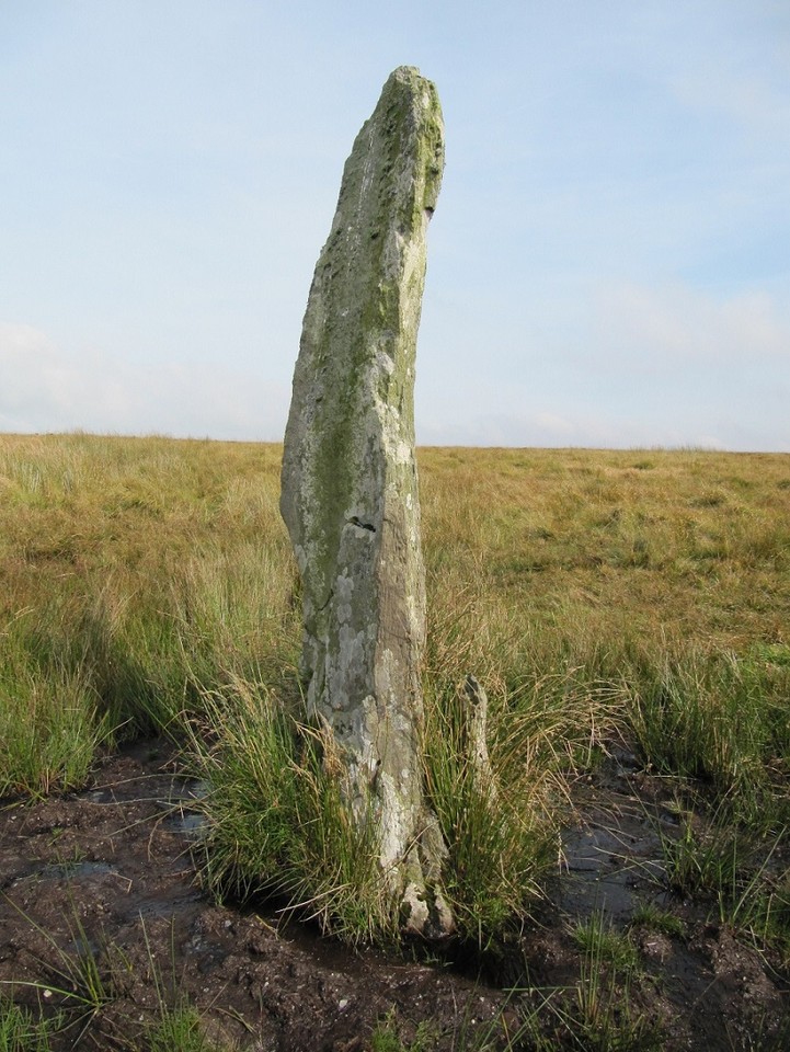
The Longstone (Exmoor) (Standing Stone / Menhir) — Images |
|
Posted by tjj 3rd October 2015ce |
The Longstone (Exmoor) (Standing Stone / Menhir) — Fieldnotes |
|
Just had a short break in north Devon, walking on Exmoor; along the coastal path from Lynton; and the green paths around some of timeless, unspoilt villages. I was aware before going that apart from Bronze Age barrows there was no exceptionally impressive prehistoric archaeology on Exmoor – we did manage to find the Long Stone and associated barrows, Longstone Barrow and Chapman Barrows. The Long Stone stands in very boggy land about half way between them. A local man who worked in the Exmoor Visitor’s Centre down in Lynmouth told us he understood there was as much of the stone beneath the surface as there was above – the stone stands approximately three metres high (nine feet) and slim in width. We started our walk by walking uphill towards the Pinkery Exploration Centre from Goat Hill Gate where there is a small road side parking area. The path up to Pinkery Pond was by and large a good one – once at the top it became considerably cooler and windier in the autumn sunshine. We then followed the fence line path to Wood Barrow Gate where we had to climb over a tricky barbed wire fence as the actual path was on the other side of the fence. At this point our progress was watched by a herd of Highland cattle as this was true moorland. The ground very boggy – good walking boots essential (I was very glad I changed my mind about going up there in light walking shoes). We stopped for a bit at the Long Stone Barrow to have a drink and a snack before going over to the Long Stone, which is quite well camouflaged against the moorland grass. It’s an intriguing stone and we couldn’t help speculating about why it was there, I imagine its purpose is closely related to the large barrows on either side of it. As we retraced our steps back to Pinkery Pond we saw a pair of red deer in the distance, one of them definitely a stag. Walking downhill into the warm afternoon sunshine following the course of a moorland stream made our walk an enjoyable experience indeed. |
Posted by tjj 3rd October 2015ce Edited 7th October 2015ce |
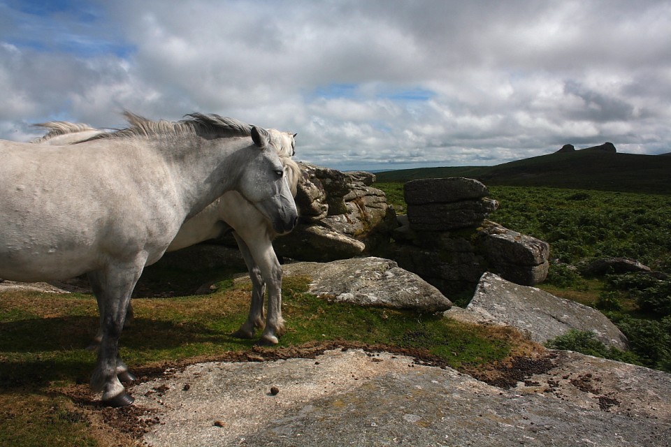
Haytor Rock (Rocky Outcrop) — Fieldnotes |
|
Directions: To the west of Haytor Vale alongside the B3387 – you can’t miss it! There are a couple of car parks you can choose from, the main one has an information centre and toilets. I bought the E.H. site guides for Merrivale, Hound Tor DMV and Grimspound from the shop. I don’t know if this site is appropriate to be included on TMA but as other rock outcrops are I assume it is? If not, apologies to the Eds who I am sure will delete anyway! This is a significant landmark and I am sure it will have been as much a curiosity for the ancients as it is for visitors today. The walk up to the Tor isn’t that far but it is a little steep. The weather wasn’t so good today and a cold wind and light drizzle took the edge off the visit. There are handy steps carved into the rocks which make climbing to the top a lot easier than it would otherwise have been. There are great all round views to be had but due to the weather the view was limited to ‘only’ several miles. This is a great place to visit when in the area. I just love these rock Tors – great places to explore! |
Posted by CARL 23rd April 2015ce |
Twitchen Barrows (Round Barrow(s)) — Miscellaneous |
|
Details of the barrows on Pastscape Twitchen Barrows (Tumuli) [O.E.] (1) Tumulus at 'A' approx. 35ft diam. - 5ft 6ins in height. Tumulus at 'B' approx 60ft diam - 5ft 6ins in height. (2) W barrow sited at SS 80313226, visited by Grinsell 26.10.59. Hole at Centre. "Two stones lying outwards, perhaps from some internal structure" (a). E barrow sited SS 80403226, visited by Grinsell 26.10.59. On heath and mutilated. (3-4) SS 80323225. A grass covered round barrow 14.0 m in diameter and 1.7 m high. Excavation hollow in centre, but Clarke's stones not visible in centre or perimeter.SS 80413225. A grass covered round barrow 20.0 m in diameter and up to 1.7 m high. The broad top has been excessively dug into by way of pits and trenches.Both barrows are in reclaimed pasture.OS 1:2500 surveys revised. (5)Scheduled 672 (6) Twitchen Barrows, a pair of prehistoric round barrows, are centred at SS 80383225, at the east end of the summit of Twitchen Ridge. The westerly barrow, centred at SS 80323225, consists of a circular mound 11.5m in diameter and 1.4m high. A possible excavation trench, 2.2m wide, 3.4m long and 0.3m deep has been driven into the summit from the south. It has been exploited by an animal scrape. There is no trace of an encircling ditch around the barrow.The easterly barrow, centred at SS 80413225, measures 19.4m north-south by 23.1m west-east and is 1.3m high. It has been extensively robbed, and is bisected by a zig-zagging robbing trench 0.5m deep running roughly west-east. To the north of this the barrow appears largely intact, whilst to the south the surface is uneven and very disturbed.Both barrows are covered in close cropped grass and lie within improved pasture. Loose stone is scattered on the surface and may be associated with modern field clearance. (7) Both mounds are clearly visible on aerial photographs from the 1940s onwards. On photographs taken on recent aerial reconnaissance flights the damage to the monuments is clear. (8-9) |
 Posted by Chance
9th March 2015ce |
Showing 1-10 of 72 posts. Most recent first | Next 10