The Modern Antiquarian
Log in
|
Register
Home
Latest Posts
Forums
Maps
Help
Browse Sites
News
Blog
Contributors
The Books
Select
-
Belgium
Denmark
Eire
France
Germany
Greece
Italy
The Netherlands
Norway
Portugal
Republic of Malta
Spain
Sweden
Switzerland
United Kingdom
England
Northern England
North Yorkshire
Osmonds Gill Cairn
Cup Marked Stone
Osmonds Gill Cairn (Cup Marked Stone) on The Modern Antiquarian, the UK & Ireland's most popular megalithic community website. 1 image, 1 fieldnote, plus information on many more ancient sites nearby and across the UK & Ireland.
Image © fitzcoraldo
Nearest Town:
Barnard Castle (10km NNW)
OS Ref (GB):
NZ052075 /
Sheet: 92
Latitude:
54° 27' 45.39" N
Longitude:
1° 55' 11.18" W
Added by
fitzcoraldo
Images (1)
Fieldnotes (1)
0 discussions
Start a topic
Show |
Hide
Web searches for Osmonds Gill Cairn
Flickr
Google
Google Images
MAGIC
The Megalithic Portal
Bing
Stone Pages
Streetmap.co.uk
Wikipedia
Show map
(inline Google Map)
- Sites within 20 km -
-
How Tallon (0.3km S) (18 posts)
Barningham Moor (0.32km NNE) (34 posts)
Eel Hill (0.32km NW) (6 posts)
Frankinshaw Cairn (1.62km ESE) (3 posts)
Osmonds Gill (2.1km ENE) (9 posts)
Holgate (3.23km SE) (3 posts)
Stone Man (4.79km E) (1 post)
Castle Steads, Gayles (5.88km E) (4 posts)
Booze (5.96km SW) (4 posts)
Gayles Moor (6.36km E) (29 posts)
Castle, Nr Reeth (6.95km SSW) (7 posts)
Low Feldom Farm (7.19km E) (0 posts)
Cock Howe (8.14km SE) (1 post)
Calverside Moor Neolithic Enclosure (8.23km SSW) (1 post)
Reeth Strip Lynchets (8.64km SSW) (3 posts)
Bowes Barrows (8.75km WNW) (1 post)
The Ravensworth Stone (8.78km ENE) (3 posts)
Grinton Round Barrow (9.08km S) (2 posts)
Aske Moor (Silver Hill) (9.39km E) (1 post)
Aske Moor (9.39km E) (0 posts)
Maiden Castle (Grinton) (9.73km SSW) (32 posts)
Mudbeck (9.77km W) (3 posts)
Mudbeck (9.77km W) (6 posts)
Harkerside Moor Circle (10.03km S) (18 posts)
Whitcliffe Scar (10.08km E) (2 posts)
Deepdale (10.14km NW) (7 posts)
How Hill, Low Whita (10.45km SSW) (4 posts)
Downholme (10.88km ESE) (3 posts)
How Hill Swaledale (11.01km ESE) (1 post)
The Butter Stone (12.1km NW) (6 posts)
Loup's Hill (12.97km WNW) (6 posts)
Stanwick Fortifications (13.37km ENE) (3 posts)
Goldsborough Rigg (13.91km WNW) (10 posts)
Cotherstone Moor (14.32km WNW) (6 posts)
Rey Cross (15.82km W) (7 posts)
Baldersdale & Howsgill (16.09km WNW) (0 posts)
Bracken Heads & Stobgreen Plantation (16.54km NW) (4 posts)
Thackwaite Beck (17.45km SSW) (1 post)
Piercebridge Barrow Alignment (17.52km ENE) (1 post)
Middleton Tyas - Five Hills (17.68km E) (1 post)
Swinkly Knoll (18.06km NW) (1 post)
Carperby (18.16km SSW) (12 posts)
Carperby B (18.26km SSW) (3 posts)
Smotherlaw (18.67km ENE) (0 posts)
Eggleston (19km NW) (3 posts)
Scorton Cursus (19.2km E) (5 posts)
Foggerthwaite Burnt Mound (19.29km NW) (1 post)
Catterick Henge (19.89km E) (3 posts)
- Facilities within 20 km -
-
The Bowes Museum (Museum: 8.8 km N)
Tan Hill Inn (Bed & Breakfast: 15.6 km WSW)
The Tan Hill Inn (Pub: 15.6 km WSW)
- Add -
-
Add news
Add an image
Add fieldnotes
Add folklore
Add miscellaneous
Add a link
-
Add a site
Add a nearby facility
Add an alternative name/spelling
Images
(click to view fullsize)
Add an image
Fieldnotes
Add fieldnotes
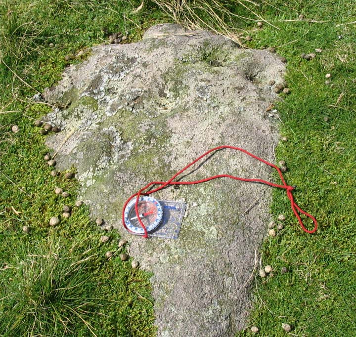
This cupmarked cairn lies close to the footpath to on the higher ground at the head of Osmonds Gill and just south of the stone circle. The cairn is appox 8m in diameter and has a cupmarked rock on the south side.
Comments (0)
|
Add a comment
|
Permalink
Posted by
fitzcoraldo
15th August 2004ce

 Posted by fitzcoraldo