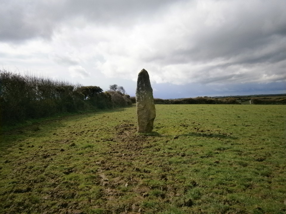
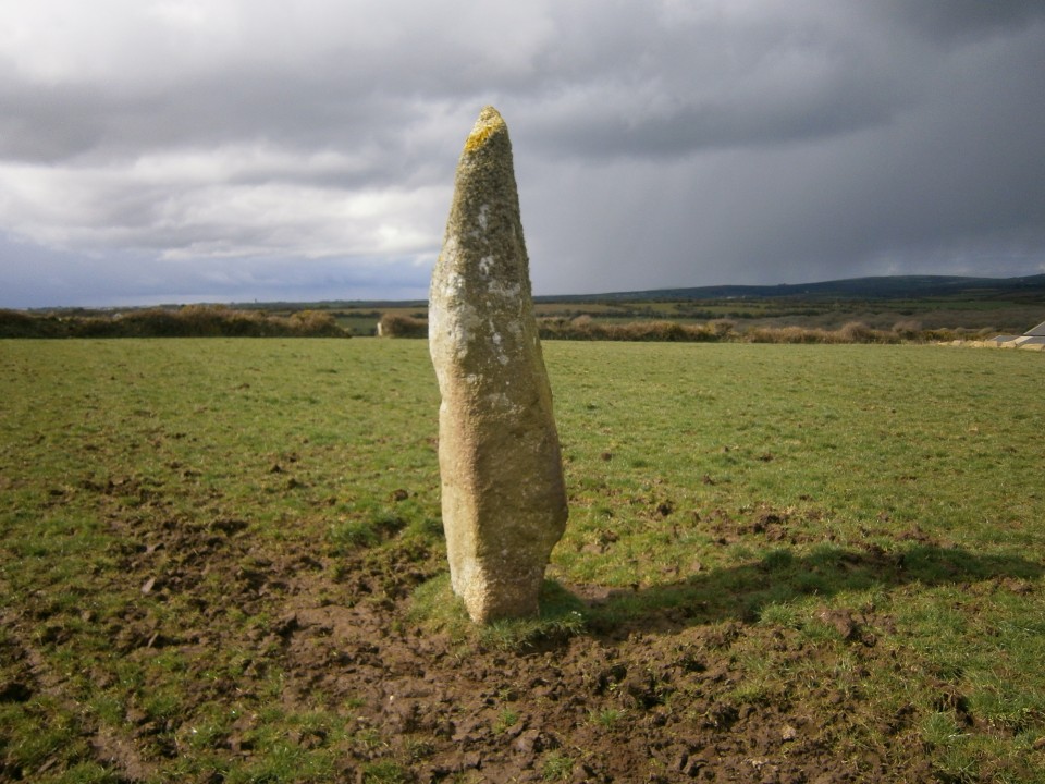
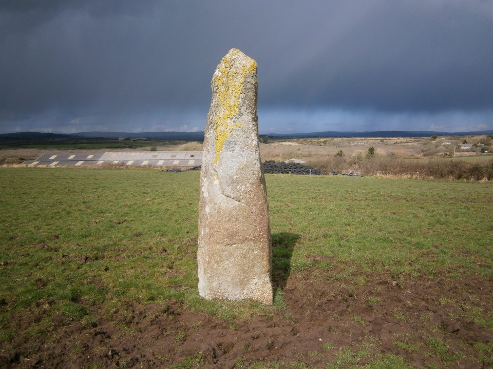
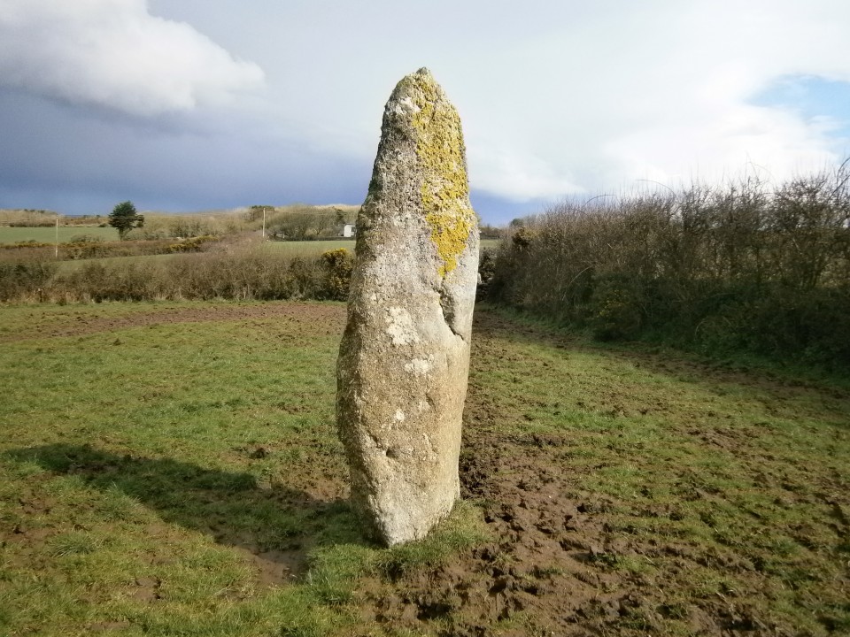
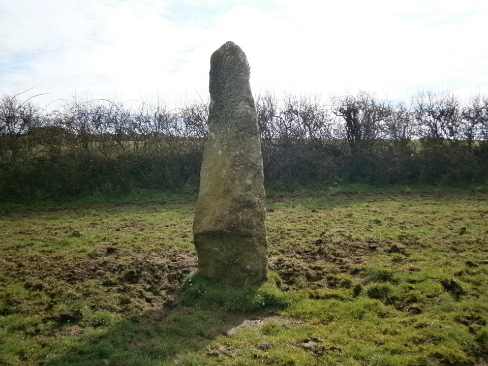
Log in
|
Register
Home
Latest Posts
Forums
Maps
Help
Browse Sites
News
Blog
Contributors
The Books
Select
-
Belgium
Denmark
Eire
France
Greece
Italy
The Netherlands
Norway
Portugal
Republic of Malta
Spain
Sweden
Switzerland
United Kingdom
England
Southern England
Cornwall
Land's End Peninsula
Chyenhal
Standing Stone / Menhir
Chyenhal (Standing Stone / Menhir) on The Modern Antiquarian, the UK & Ireland's most popular megalithic community website. The site also contains a vast wealth of information on many more ancient sites across the UK & Ireland.
No image available
Nearest Town:
Newlyn (2km NE)
OS Ref (GB):
SW451275 /
Sheet: 203
Latitude:
50° 5' 31.8" N
Longitude:
5° 33' 51.45" W
Added by
pure joy
Miscellaneous (1)
0 discussions
Start a topic
Show |
Hide
Web searches for Chyenhal
Flash Earth
Flickr
Google
Google Images
MAGIC
The Megalithic Portal
Multimap 1:25000
Stone Pages
Streetmap.co.uk
Wikipedia
Show map
(inline Google Map)
- Sites within 20 km -
-
Sheffield Menhir (0.7km ENE) (1 post)
Kerris (0.7km WSW) (8 posts)
Faugan Round (0.71km N) (1 post)
Ennis Farm (0.86km WNW) (0 posts)
Redhouse (0.95km SSW) (1 post)
Tresvennack Pillar (0.98km W) (3 posts)
Paul Celtic Cross (1.35km E) (3 posts)
Drift Stones (1.61km W) (28 posts)
Castallack (2.02km SSE) (5 posts)
Castallack 2 (2.04km SSE) (3 posts)
Castallack Round (2.13km S) (2 posts)
Castallack Carn (2.13km S) (4 posts)
Swingate (2.37km SE) (5 posts)
Merlin's Rock (2.48km ESE) (1 post)
Toldavas (2.52km WSW) (3 posts)
Boleigh Fogou (2.64km SSW) (37 posts)
The Blind Fiddler (2.66km W) (31 posts)
Kemyel (2.86km SSE) (2 posts)
Lesingey Round (2.91km N) (1 post)
Trelew Menhir (2.95km WSW) (12 posts)
The Pipers (3.13km SSW) (57 posts)
Boscawen-Un Menhir (3.39km W) (12 posts)
Changwens Menhir (3.4km WSW) (3 posts)
The Merry Maidens (3.47km SSW) (92 posts)
Pridden (3.5km WSW) (3 posts)
Tregiffian (3.67km SSW) (61 posts)
Boscawen Menhir (3.69km WSW) (10 posts)
Gun Rith Menhir (3.71km SW) (28 posts)
Sancreed Holy Well (3.75km W) (23 posts)
Bosckawen-Un (3.89km WSW) (105 posts)
Boscawen-Un (footpath) (3.89km WSW) (5 posts)
Choone Holed stone (3.99km SW) (3 posts)
Goldherring (4.04km W) (3 posts)
Creeg Tol (4.09km W) (7 posts)
Sancreed Beacon (4.1km W) (7 posts)
Lescudjack Castle (4.24km NNE) (14 posts)
Boscawen-Ros (4.26km SSW) (16 posts)
Tremayne (4.42km NW) (3 posts)
Caer Bran (4.63km W) (14 posts)
St. Buryan Menhir (4.76km WSW) (9 posts)
Trewern Round (4.84km NW) (2 posts)
Trewern (4.88km NW) (1 post)
Brane Long Barrow (4.91km W) (5 posts)
Brane (4.93km W) (23 posts)
Carn Euny Fogou & Village (5.05km W) (101 posts)
Madron Holy Well (5.32km NNW) (26 posts)
St Euny's Well (5.36km W) (13 posts)
Treverven (5.53km SW) (10 posts)
Rosemorran (5.54km NNE) (3 posts)
Rosemorran Fogou (5.58km NNE) (1 post)
Higher Bodinnar Fogou (5.75km WNW) (3 posts)
Bartine Castle Enclosure (5.86km W) (5 posts)
Mount Whistle hedge stone (6.03km NW) (5 posts)
Botrea Barrows (6.04km WNW) (1 post)
Alsia Holy Well (6.25km WSW) (11 posts)
Wheal Buller Menhir (6.5km WNW) (7 posts)
Chapel Carn Brea long cairn (6.52km W) (8 posts)
Carfury (6.58km NNW) (15 posts)
Chapel Carn Brea (6.59km W) (27 posts)
Lanyon Quoit (6.62km NW) (92 posts)
Tremenheere (6.65km NE) (4 posts)
St. Michael's Mount (6.72km ENE) (13 posts)
Tredinnick Farm (6.72km NNW) (2 posts)
West Lanyon Quoit (6.88km NW) (7 posts)
Bosiliack Barrow (6.98km NW) (26 posts)
Chapel Carn Brea (destroyed?) (6.99km W) (2 posts)
Boswens Croft (7.33km WNW) (13 posts)
Mulfra courtyard houses (7.36km NNW) (8 posts)
Try (7.54km N) (3 posts)
Treryn Dinas (7.55km SW) (21 posts)
Boskednan Cairn (7.58km NW) (19 posts)
Kerrow Bosullow (7.64km NW) (2 posts)
Boskednan Southern Cairn (7.66km NNW) (5 posts)
Bodrifty (7.7km NNW) (5 posts)
Bodrifty Reconstruction (7.7km NNW) (2 posts)
Nine Stones of Boskednan (7.75km NNW) (79 posts)
Tregiffian Vean (7.77km WSW) (13 posts)
Chysauster Village (7.78km N) (76 posts)
Bosullow Trehyllys Courtyard House Settlement (7.89km WNW) (13 posts)
Mulfra Quoit (7.89km NNW) (61 posts)
Men-An-Tol (7.91km NW) (100 posts)
Bodrifty Iron Age Settlement (7.91km NNW) (12 posts)
Tregeseal Holed Stones (7.94km WNW) (27 posts)
Chun Castle (8.01km WNW) (21 posts)
Truthwall Common (8.02km WNW) (14 posts)
Hailglower Farm round barrow (8.02km W) (2 posts)
Mulfra Hill round barrows (8.09km NNW) (2 posts)
Tregeseal Stone Circle and Carn Kenidjack (8.11km WNW) (69 posts)
Boslow Stone (8.12km WNW) (8 posts)
Men Scryfa (8.15km NW) (43 posts)
Chûn Quoit & Boswens Menhir (8.17km WNW) (68 posts)
The Four Parish Stone (8.18km NW) (4 posts)
Bodrifty Barrows (8.2km NNW) (3 posts)
Castle-an-Dinas (8.22km NNE) (13 posts)
Tonkins Downs (8.25km NNE) (3 posts)
Carn Kenidjack (8.27km WNW) (13 posts)
Trye Hillfort (8.29km N) (2 posts)
Portheras Common Barrow (8.32km WNW) (17 posts)
Trevear (8.4km WSW) (1 post)
Tregeseal Entrance Grave (8.43km W) (5 posts)
Higher Botallack round barrow (8.55km WNW) (5 posts)
Bosporthennis 'Beehive Hut' (8.6km NNW) (25 posts)
Trevean Round (8.66km NW) (3 posts)
Trevowhan (8.67km NW) (1 post)
Watch Croft (8.72km NW) (12 posts)
Conquer Downs (8.77km N) (1 post)
St. Levan's Stone (8.83km SW) (10 posts)
Escalls Cliff cairn (8.84km WSW) (6 posts)
Carn Bean barrow (8.85km WNW) (5 posts)
The Selus Stone (8.87km W) (3 posts)
Kerrowe Carved Stone (8.88km N) (2 posts)
The Beacon (8.97km NNW) (5 posts)
Bosporthennis Quoit (9.11km NNW) (14 posts)
Porthmeor (Treen Common) (9.11km NNW) (12 posts)
Carn Galva (9.13km NW) (16 posts)
Carn Creis Barrows (9.62km W) (6 posts)
Cudden Point (9.66km ENE) (2 posts)
Treen Entrance Graves (9.67km NNW) (21 posts)
Porthmear Fogou (9.73km NNW) (1 post)
Kerrow (9.79km NNW) (1 post)
Porthmeor Roundhouses (9.82km NNW) (4 posts)
Sennen (9.85km WSW) (6 posts)
Porthmeor (9.87km NNW) (16 posts)
Botallack (10.08km W) (2 posts)
Pennance (10.09km NNW) (5 posts)
Chypraze (10.18km WNW) (13 posts)
Mayon Cliff Barrows (10.27km WSW) (18 posts)
Carn Gluze (10.29km W) (51 posts)
Treveneague Fogou (10.31km ENE) (3 posts)
Lower Boscaswell Fogou (10.36km WNW) (12 posts)
Bosewednack Menhir (10.41km NNW) (1 post)
Maen Castle (10.41km WSW) (28 posts)
Carn Les Boel (10.48km WSW) (5 posts)
Kerrowe Menhir (10.59km NNW) (1 post)
Pendeen Vau (10.68km WNW) (20 posts)
Zennor Quoit (10.71km N) (50 posts)
Kenidjack Castle (10.83km W) (29 posts)
Trencrom Hill (10.96km NE) (29 posts)
Sperris Quoit (10.97km N) (17 posts)
Cape Cornwall (10.98km W) (5 posts)
Trink Hill (10.99km NNE) (4 posts)
Trencrom Hill Well (11km NE) (4 posts)
Sperris Croft (11.1km N) (6 posts)
Gurnard's Head (11.13km NNW) (19 posts)
Towednack Double Armed Cross (11.27km NNE) (3 posts)
Giant's Rock (11.29km NNW) (5 posts)
Wicca Round (11.3km N) (1 post)
Trendrine Hill (11.53km N) (13 posts)
The Bowl Rock (11.66km NE) (6 posts)
Beersheba (12.09km NE) (13 posts)
Rosewall Hill (12.64km NNE) (6 posts)
Carbis Bay Longstone (13.27km NE) (9 posts)
The Fairy Well (13.95km NE) (5 posts)
Trewavas Cliff (14.51km E) (9 posts)
Castle Pencaire (14.95km ENE) (6 posts)
- Facilities within 20 km -
-
Castle Horneck (Youth Hostel: 3.2 km N)
Penzance (Youth Hostel: 3.2 km N)
Boleigh Farm (Camping Site: 4.6 km SW)
St. Buryan Inn (Pub: 4.7 km SW)
Lanyon Tearoom (Cafe: 4.9 km NW)
Cardinney Caravan and ... (Camping Site: 5.3 km W)
Lands End (Youth Hostel: 9.2 km W)
The North Inn (Camping Site: 9.8 km WNW)
Trewellard Manor Farm (Holiday Cottage: 9.9 km WNW)
- Add -
-
Add news
Add an image
Add fieldnotes
Add folklore
Add miscellaneous
Add a link
-
Add a site
Add a nearby facility
Add an alternative name/spelling
Miscellaneous
Add miscellaneous
Chyenhal menhir
SW451275 - 2.6m tall menhir re-erected early in the 19th Century. 2 more stones once stood in the next field but have now disappeared. On private land, presumably that of Chyenhal Farm.
Comments (0)
|
Add a comment
|
Permalink
Posted by
pure joy
16th January 2003ce