The Modern Antiquarian
Log in
|
Register
Home
Latest Posts
Forums
Maps
Help
Browse Sites
News
Blog
Contributors
The Books
Select
-
Belgium
Denmark
Eire
France
Germany
Greece
Italy
The Netherlands
Norway
Portugal
Republic of Malta
Spain
Sweden
Switzerland
United Kingdom
County Cork
Reananerree
Stone Circle
Reananerree (Stone Circle) on The Modern Antiquarian, the UK & Ireland's most popular megalithic community website. 10 images, 1 fieldnote, plus information on many more ancient sites nearby and across the UK & Ireland.
Image © Charles Coughlan
Nearest Town:
Dunmanway (20km SSE)
OS Ref (IE):
W203729 /
Sheet: 79
Latitude:
51° 54' 9.8" N
Longitude:
9° 9' 29.2" W
Added by
IronMan
Images (10)
Fieldnotes (1)
0 discussions
Start a topic
Show |
Hide
Web searches for Reananerree
Flickr
Google
Google Images
The Megalithic Portal
Bing
Stone Pages
Wikipedia
Show map
(inline Google Map)
- Sites within 20 km -
-
Reananarree (0.14km ESE) (3 posts)
Gortanimill (1.3km NNE) (16 posts)
Derryfineen (1.38km WSW) (6 posts)
Derryfineen (1.44km SW) (5 posts)
Lack More (1.66km SW) (9 posts)
Gortnatubbrid (3.16km NW) (13 posts)
Gortnatubbrid (3.16km NW) (4 posts)
St Abban's Grave (3.52km N) (4 posts)
St Abban's Grave (3.52km N) (1 post)
Shanacloon (3.52km N) (5 posts)
Ballymakeery (3.63km NNE) (5 posts)
Cools (4.39km ENE) (3 posts)
Ballyvoge 1 (5.75km E) (6 posts)
Turnaspidogy (6.44km S) (8 posts)
Lumnagh More (6.54km W) (0 posts)
Kylefinchin (6.57km E) (1 post)
Gorteennakilla (6.98km WSW) (6 posts)
Lissacresig (7km ENE) (3 posts)
Kylefinchin 2 (7.08km E) (5 posts)
Inchinlinane (7.5km ENE) (5 posts)
Currahy (7.5km SW) (4 posts)
Lissacresig 2 (7.57km ENE) (5 posts)
Lissacresig 3 (7.57km ENE) (4 posts)
Lissacresig 1 (7.66km ENE) (4 posts)
Keamcorravooly (8.32km SW) (4 posts)
Keamcorravooly (8.38km SW) (11 posts)
Gortnalicky (9.05km ENE) (1 post)
Carrigaphooca (9.08km ENE) (7 posts)
Clashmaguire (9.11km ENE) (1 post)
An Screathan Mór (9.37km SW) (3 posts)
Teergay (9.48km E) (8 posts)
Clashmaguire (9.49km NE) (2 posts)
Carrigonirtane (9.88km NE) (4 posts)
Cabragh (9.91km NE) (4 posts)
Cabragh (10.16km NE) (4 posts)
Cabragh N (10.16km NE) (6 posts)
Western Pap (10.72km SW) (9 posts)
Gortafludig (10.77km SW) (0 posts)
Grousemount (10.8km WSW) (3 posts)
Carrigonirtane (11.22km NE) (6 posts)
Gortyleahy (11.8km E) (4 posts)
Knocknakilla (11.96km NE) (0 posts)
Kilboultragh (12.08km ENE) (1 post)
Coolmountain (12.13km S) (7 posts)
Farrannahineeny (12.23km SSE) (16 posts)
Knockraheen (12.34km NE) (19 posts)
Coolaclevane (12.35km ESE) (3 posts)
Knockaunnagorp (12.43km ESE) (0 posts)
Dooneens (12.46km SW) (9 posts)
Dooneens (12.48km SW) (4 posts)
Coolaclevane (12.49km ESE) (3 posts)
Glantane South (12.55km NE) (8 posts)
Scrahanard (12.66km ENE) (15 posts)
Lackaduv (12.88km ENE) (5 posts)
Knockanereagh (12.99km ESE) (8 posts)
Glantane East S (13.05km NE) (16 posts)
Carriganimmy (13.27km NE) (15 posts)
Inchincurka (13.52km SSE) (15 posts)
Glantane East N (13.65km NE) (14 posts)
Glantane East N (13.65km NE) (5 posts)
Glantane East (13.96km NE) (7 posts)
Rossnakilla (14.04km E) (0 posts)
Rossnakilla (14.04km E) (9 posts)
Eastern Pap (14.43km NW) (6 posts)
The Paps of Anu (14.63km WNW) (7 posts)
Bealick (14.64km ENE) (3 posts)
Knocknakilla (14.74km NE) (24 posts)
Knockane (15.1km E) (8 posts)
Reanacaheragh (15.33km ESE) (0 posts)
Claragh W (15.67km N) (2 posts)
Kilmeedy W (15.67km N) (0 posts)
Cloghboola More (15.76km NNE) (0 posts)
Cloghboola Beg (15.76km NNE) (0 posts)
Bealick (15.77km ENE) (0 posts)
Kilmeedy E (15.89km N) (0 posts)
Claragh E (15.89km N) (2 posts)
Cloghboola Beg (15.94km NE) (12 posts)
Barnadivane (15.96km E) (0 posts)
Moneygaff West (16.13km ESE) (5 posts)
Cappaboy Beg SE (16.35km SW) (7 posts)
Cappaboy Beg (16.43km SW) (2 posts)
Cappaboy Beg (16.43km SW) (3 posts)
Inchireagh (16.53km S) (11 posts)
Cappaboy Beg (16.63km SW) (2 posts)
City of Shrone (16.69km NW) (15 posts)
City of Shrone (16.69km NW) (2 posts)
Cappaboy Beg (16.7km SW) (4 posts)
Cappaboy Beg NW (16.82km SW) (6 posts)
Caherbaroul (16.83km ENE) (7 posts)
Knockagappul 2 (16.85km NE) (6 posts)
Knockagappul 1 (16.91km ENE) (5 posts)
Borlin Valley Standing Stone (16.94km WSW) (7 posts)
Knocknagappul (17.03km ENE) (3 posts)
Derrynacaheragh (17.33km S) (2 posts)
Knocknagappul (17.36km ENE) (3 posts)
Knocknagappul (17.37km NE) (5 posts)
Knocknagappul (17.42km NE) (2 posts)
Inchinanagh (17.47km WSW) (6 posts)
Stone Row, partially ruined (17.48km NE) (5 posts)
Clearagh (17.7km E) (2 posts)
Behagullane (17.76km SE) (1 post)
Lackanashinagh (17.85km ESE) (0 posts)
Cousane (17.95km SSW) (4 posts)
Rosnascalp (17.95km E) (4 posts)
Kilberrihert large wedge tomb damaged (18.04km ENE) (2 posts)
Farnanes (18.18km S) (9 posts)
Cousane (18.41km SSW) (10 posts)
Derrynafinchin (18.65km SW) (1 post)
Derrynafinchin (18.72km SW) (16 posts)
Kinneigh (18.85km ESE) (4 posts)
Derrynasafagh (19.14km SSE) (3 posts)
Deelish (19.17km ENE) (4 posts)
Garranereagh (19.19km E) (4 posts)
Maughanaclea NE (19.2km SSW) (9 posts)
Hornhill (19.34km E) (8 posts)
Laharankeal (19.36km ENE) (4 posts)
Knocknaneirk NE (19.37km E) (13 posts)
Toom (19.38km SE) (4 posts)
Carrigagulla NE (19.49km ENE) (10 posts)
Carrigagulla (19.58km ENE) (7 posts)
Knocknaneirk SW (19.59km E) (17 posts)
Laharankeal (19.6km ENE) (1 post)
Carrigagulla (19.67km ENE) (20 posts)
Cahermuckee (19.86km SW) (5 posts)
Hornhill (19.91km E) (5 posts)
Gurteen (19.97km WSW) (24 posts)
Gurteen (20km WSW) (12 posts)
- Add -
-
Add news
Add an image
Add fieldnotes
Add folklore
Add miscellaneous
Add a link
-
Add a site
Add a nearby facility
Add an alternative name/spelling
Images
(click to view fullsize)
Add an image
Fieldnotes
Add fieldnotes
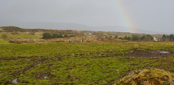
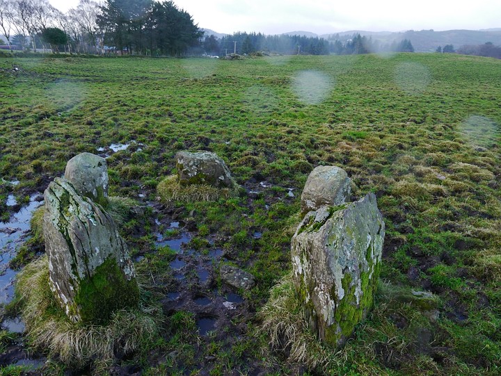
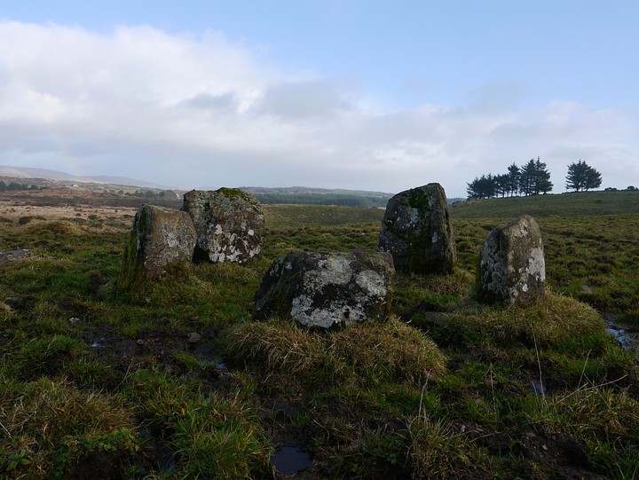
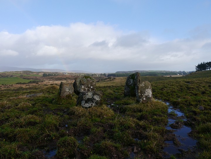
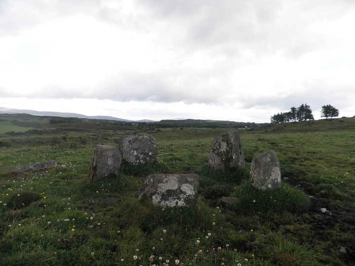
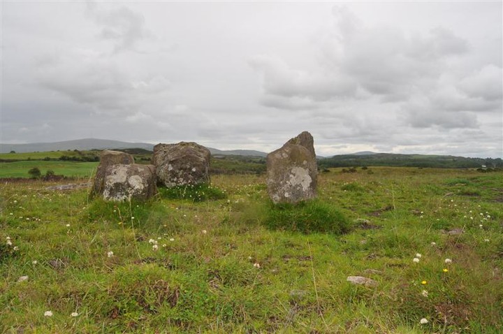
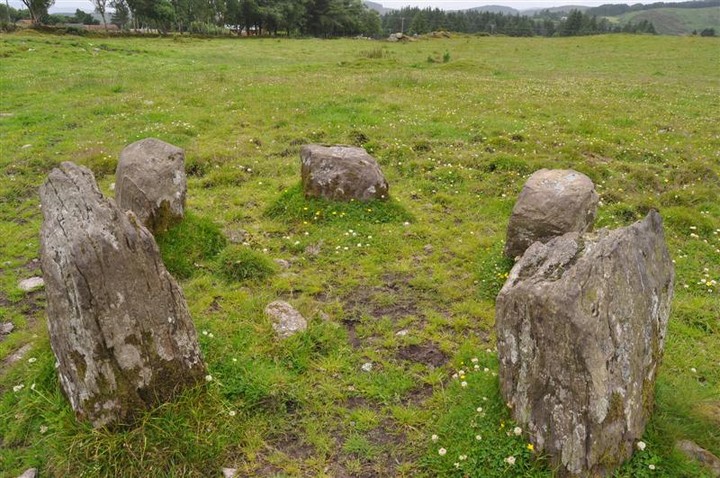
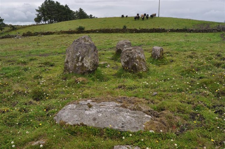
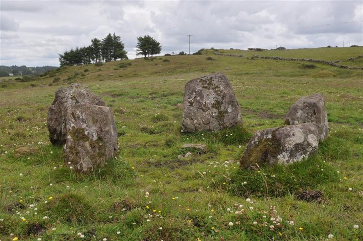
This stone circle is very easy to find and access. It is very close to the tiny hamlet of Reananerree. It is a lovely 5 stone circle on some bleak countryside with views to the north and west.
Comments (0)
|
Add a comment
|
Permalink
Posted by
bawn79
24th September 2011ce