|
|

|
|
Down Farm GroupRound Barrow(s)
|
||||||||||||||||||||||||
|
|
|
Images (click to view fullsize) |
|
|
Fieldnotes |
|
|
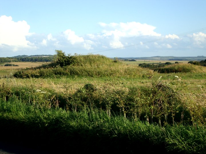
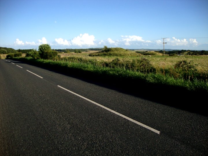
Fieldnotes - Visited Late July 2012 Another classic drive-by TMA site. Although these barrows lie within the parish boundary of Pewsey, they are only a field away from the Everleigh Barrow Group and should be considered as a sub-set of that group. I really wanted to have a good look around this barrow group as it is said to have contained virtually every kind of round barrow from a Bell, Bowl, Disc, Pond, Saucer and even an elusive "Cone" barrow. As it turned out there was no direct access and I couldn't be bothered to arrange it with the land owner. The last time I visited the area, the farm was a dairy but this time the field was full of very fat and sunburnt pigs. All their mud pools had dried up and the ones that were not in their huts were wondering around looking angrily at anything that came near them. I decided to leave my visit for another day and carried on towards Everleigh and the Plain. |
 Posted by Chance
9th August 2012ce |
Miscellaneous |
|
|
Pewsey 5 Details of Barrow on Pastscape A bowl barrow which may be Colt Hoare's `Cone Barrow' which contained a primary and secondary cremation SU 18755664: Pewsey 5, a bowl barrow 16 paces in diameter and 7ft high. This may be Colt Hoare's `Cone Barrow' which contained a primary cremation within a chalk cist and a secondary cremation with a small bronze dagger. (See also SU 15 NE 89) (1-2) Pewsey 5, as described and measured by Grinsell. Surveyed at 1:2500. (3) Originally recorded as Pewsey 5 by Goddard. (4) -------------------------------------------------------------------------------- SOURCE TEXT -------------------------------------------------------------------------------- ( 1) General reference VCH Wilts. 1. 1957. 187. (L.V Grinsell) ( 3) Field Investigators Comments F1 JWS 27-MAR-73 ( 2) General reference History of Ancient South Wilts. 1. 1810. 191 (R. Colt Hoare) ( 4) General reference Wilts. Archaeol. Natur. Hist. Mag. 38, 1913-14, 306-307 (E.H Goddard) |
Posted by Chance 9th August 2012ce |
|
Details of Barrow Group on Pastscape A cemetery of eight round barrows which occupies a prominent position, below the crest of a south west facing spur, on the northern edge of Salisbury Plain, 320 metres south east of Down Farm. Three of the barrows survive as substantial earthworks. Of these the most northerly example is a bell barrow with a mound 16 metres in diameter and a sloping bern 5 metres wide. In the centre of the mound, which reaches a height of 3 metres, are traces of disturbance, most probably resulting from an excavation by Sir Richard Colt Hoare in the early 19th century which uncovered two burials of cremated bone. South of the bell barrow is a bowl barrow which has a mound 20 metres in diameter and reaches a height of 2.25 metres. The most southerly barrow of the group is also a bowl barrow. It has a mound 30 metres in diameter and 2.5 metres high. In a line between this barrow and the bell barrow to the north east are a further two bowl barrows. These have been greatly reduced by cultivation but are still visible as low mounds 20 metres in diameter. They were partially excavated in 1958 by Faith de Mallet Vatcher who found the remains of a wooden coffin and a disarticulated burial in the northenmost barrow and an empty grave in the other. The monument also includes the site of a further three barrows. These are no longer visible of the surface but were also examined by Vatcher who identified them as saucer barrows. The site of a further possible barrow is thought to lie in the north east corner of the group. Scheduled. (Centred SU 18735662) Tumuli (LB). (1) A barrow cemetery with bowl, bell, disc and pond barrows. The first known archaeological excavations were carried out by Colt Hoare. One barrow (either Pewsey 4, 6 or 7) was found to have contained a primary cremation with a bronze awl, two shale beads and part of a cup. Another barrow, listed by Colt Hoare as `Cone Barrow' (Pewsey 3 or 5) contained a primary cremation within a cist and a secondary cremation with a small dagger (2). The pond barrow was identified by Grinsell and is visible on APs. (3-4) Excavations took place on five of the barrows in 1958 and as a result three bowl barrows were re-identified as disc barrows, one of which contained Neolithic pottery indicating Neolithic occupation within the vicinity. (5) -------------------------------------------------------------------------------- SOURCE TEXT -------------------------------------------------------------------------------- ( 1) Ordnance Survey Map (Scale / Date) OS 6" Prov ( 2) by Sir Richard Colt Hoare; introduction by Jack Simmons and D D A Simpson 1975 The ancient history of Wiltshire 1 Page(s)191 ( 3) edited by R B Pugh and Elizabeth Crittall 1957 A history of Wiltshire: volume 1, part 1 The Victoria history of the counties of England Page(s)187, 210, 225 ( 4) Aerial photograph AP OS 71/476 109, 110, 07-SEP-1971 ( 5) The Wiltshire archaeological and natural history magazine F de Mallet 57, 1958-60 Page(s)339-51 ( 6) Scheduled Monument Notification 14-JUL-1999 |
Posted by Chance 9th August 2012ce |