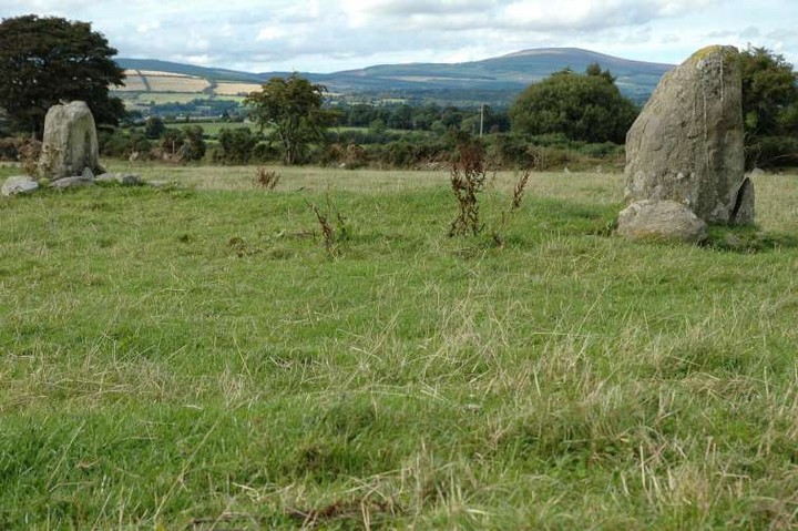
Log in
|
Register
Home
Latest Posts
Forums
Maps
Help
Browse Sites
News
Blog
Contributors
The Books
Select
-
Belgium
Denmark
Eire
France
Greece
Italy
The Netherlands
Norway
Portugal
Republic of Malta
Spain
Sweden
Switzerland
United Kingdom
County Wicklow
Parkmore
Standing Stones
Parkmore (Standing Stones) on The Modern Antiquarian, the UK & Ireland's most popular megalithic community website. 3 images, plus information on many more ancient sites nearby and across the UK & Ireland.
Image © ryaner
Nearest Town:
Laragh (7km W)
OS Ref (IE):
T212961 /
Sheet: 56
Latitude:
53° 0' 6.99" N
Longitude:
6° 11' 39.85" W
Added by
FourWinds
Images (3)
1 discussion topic
Start a topic
Show |
Hide
Web searches for Parkmore
Flash Earth
Flickr
Google
Google Images
The Megalithic Portal
Bing
Stone Pages
Wikipedia
Show map
(inline Google Map)
- Sites within 20 km -
-
Sleanaglogh (2.04km SSE) (2 posts)
Derrylossary Church (6.03km NW) (2 posts)
Drummin (6.86km WNW) (4 posts)
Baltynanima (6.92km NW) (2 posts)
Drummin I (6.92km WNW) (2 posts)
Drummin II (7km WNW) (0 posts)
The Gossan Stones (7.2km W) (0 posts)
Drummin III (7.2km WNW) (1 post)
Drummin IV (7.2km WNW) (2 posts)
The Witch's Stone (8.04km WNW) (5 posts)
St. Kevin's Cathedral (8.79km W) (2 posts)
Brockagh II (8.82km W) (3 posts)
Glendalough (8.88km W) (0 posts)
The Deer Stone (8.88km W) (3 posts)
St. Kevin's Kitchen (8.89km W) (1 post)
Glendasan River (8.9km W) (3 posts)
Sevenchurches (8.9km W) (2 posts)
Brockagh (8.91km W) (5 posts)
The Seven Fonts (8.91km W) (5 posts)
Glendalough Cottage (9.01km W) (3 posts)
Sevenchurches or Camaderry (9.01km W) (2 posts)
Stone II (9.29km WSW) (1 post)
Stone I (10.2km WSW) (1 post)
Springfarm (10.53km SE) (1 post)
Springfarm 2 (10.64km SE) (5 posts)
St. Kevin's Bed (Glendalough) (10.66km W) (1 post)
Springfarm 3 (10.95km SE) (2 posts)
Kingston (11.38km S) (0 posts)
Kilbeg (12.54km W) (3 posts)
Cullen Upper (12.62km ESE) (4 posts)
The Motte Stone (12.79km S) (0 posts)
Fananierin (12.88km WSW) (4 posts)
Glasnamullen Holy Well (13.2km NNW) (1 post)
Castletimon (13.62km ESE) (2 posts)
Castletimon (13.87km ESE) (3 posts)
Brittas (13.93km ESE) (3 posts)
Downs Hill (14.53km NNE) (0 posts)
The Coffin Stone (Djouce) (14.67km NNW) (0 posts)
Rock Art (14.93km SSW) (0 posts)
Magnacool Lower (15.18km SSW) (9 posts)
Cloneen (15.25km SSW) (0 posts)
Ballygahan Upper (15.58km S) (4 posts)
Kilmurry South (16.1km NNE) (2 posts)
Ballyremon Commons (16.29km N) (4 posts)
Long Hill (16.29km N) (0 posts)
The Druid's Stone (16.29km SSW) (1 post)
Daw (17.86km WNW) (0 posts)
Rocky Valley (18.4km N) (0 posts)
Onagh (19.13km NNW) (6 posts)
Sheepwalk (19.39km SSE) (0 posts)
- Add -
-
Add news
Add an image
Add fieldnotes
Add folklore
Add miscellaneous
Add a link
-
Add a site
Add a nearby facility
Add an alternative name/spelling
Images
(click to view fullsize)
Add an image