The Modern Antiquarian
Log in
|
Register
Home
Latest Posts
Forums
Maps
Help
Browse Sites
News
Blog
Contributors
The Books
Select
-
Belgium
Denmark
Eire
France
Germany
Greece
Italy
The Netherlands
Norway
Portugal
Republic of Malta
Spain
Sweden
Switzerland
United Kingdom
County Tipperary
Rathneaveen
Rathneaveen
Standing Stone / Menhir
Rathneaveen (Standing Stone / Menhir) on The Modern Antiquarian, the UK & Ireland's most popular megalithic community website. 1 image, 1 fieldnote, plus information on many more ancient sites nearby and across the UK & Ireland.
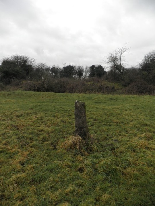
Image © Bawn79 © 2011
Nearest Town:
Tipperary (4km S)
OS Ref (IE):
R897395 /
Sheet: 66
Latitude:
52° 30' 24.84" N
Longitude:
8° 9' 6.15" W
Added by
bawn79
Images (1)
Fieldnotes (1)
0 discussions
Start a topic
Show |
Hide
Web searches for Rathneaveen
Flickr
Google
Google Images
The Megalithic Portal
Bing
Stone Pages
Wikipedia
Show map
(inline Google Map)
- Sites within 20 km -
-
Rathneaveen (0.54km SE) (2 posts)
Springfield (2.66km SW) (2 posts)
Ballynilard (5.51km SW) (4 posts)
Donaskeagh (5.73km ENE) (2 posts)
Clonpet (5.76km SSW) (1 post)
Knockballynoe (6.24km E) (2 posts)
Knockballynoe (6.34km E) (2 posts)
Kilfeakle Churchquarter (7.23km E) (3 posts)
Ballagh II (8.12km SE) (1 post)
Rock an Tarbh (8.14km S) (3 posts)
Ballagh I (8.18km SE) (3 posts)
Ballyconry (8.22km WSW) (2 posts)
Ballyconry (8.36km WSW) (6 posts)
Gortavoher (North) (9km S) (4 posts)
Lattin (9.01km WSW) (3 posts)
Lattin (9.63km WSW) (3 posts)
Gortavoher (9.69km S) (1 post)
Cahernahallia (9.78km NW) (1 post)
Cahernahallia (9.78km NW) (2 posts)
Longstone (9.97km WSW) (8 posts)
Longstone (9.97km WSW) (1 post)
Longstone (9.97km WSW) (3 posts)
Shrough (10.39km SSW) (16 posts)
Glenbane (10.64km WSW) (1 post)
Rossadrehid (10.84km SE) (2 posts)
Foilaclug (11.43km N) (3 posts)
Sarsfields Rock (11.6km W) (3 posts)
St Berriherts Kyle (11.92km SE) (5 posts)
Corderry (11.99km SW) (8 posts)
Kilmoylan Upper (12km NW) (3 posts)
Gortnageragh (13.26km NW) (2 posts)
Glencarbry (13.84km NNE) (1 post)
Cloonyconry More (14.03km WSW) (4 posts)
Knocksefin (14.58km W) (1 post)
Lackanagoneeny (14.98km NW) (4 posts)
Ballymorris (14.99km ESE) (1 post)
Liseen (15.16km W) (3 posts)
Baunteen (15.3km SSW) (1 post)
Cnoc Greine (15.32km W) (3 posts)
Baunteen (15.34km SSW) (3 posts)
Knockroe (15.38km W) (1 post)
Toureen Peacaun (15.45km ESE) (3 posts)
Laghtshanaquilla (15.45km SE) (4 posts)
Knocsefin (15.53km W) (3 posts)
Greenane (15.71km SSE) (2 posts)
Lissard (15.73km SW) (10 posts)
Blackstairs (15.82km N) (4 posts)
Blackstairs (15.82km N) (3 posts)
Harps of Cliu (15.89km S) (5 posts)
Garracummer (15.99km N) (8 posts)
Sturrakeen (16.03km SE) (4 posts)
Duntryleague Cairn (16.16km SW) (1 post)
Duntryleague (16.16km SW) (32 posts)
Lissard (16.41km SW) (3 posts)
Foilycleara (16.43km NNW) (3 posts)
Cromwell Hill (16.65km WSW) (7 posts)
Tuogh (16.76km WNW) (0 posts)
Ballinree South (16.81km E) (2 posts)
Slieveanard (16.94km ESE) (6 posts)
Ardmayle (17.03km ENE) (6 posts)
Coolalough (17.81km WSW) (5 posts)
Aughsullish SW (17.99km NNW) (6 posts)
Aughsullish NW (18.07km NNW) (1 post)
Hospital (18.08km WSW) (2 posts)
Knockshanbrittas (A) (18.08km NNW) (6 posts)
Knockgraffon Motte (18.23km ESE) (5 posts)
Carron Henge (18.29km E) (8 posts)
Longstone (18.34km W) (2 posts)
Clogher Hill (18.47km WSW) (2 posts)
Lodge (18.51km WSW) (4 posts)
Coolalough (18.72km WSW) (2 posts)
Temple Hill (18.76km SSW) (6 posts)
Rath na Drinne (18.81km E) (4 posts)
Corralough (18.87km ENE) (2 posts)
Coolalough (19.43km WSW) (2 posts)
Lissava (19.52km ESE) (4 posts)
Loughbrack (19.7km N) (11 posts)
Gotoon (19.74km WSW) (2 posts)
Shanballyedmond (19.94km NW) (17 posts)
Ballingarry (19.97km SW) (3 posts)
Cloghabreedy (19.99km ESE) (1 post)
- Add -
-
Add news
Add an image
Add fieldnotes
Add folklore
Add miscellaneous
Add a link
-
Add a site
Add a nearby facility
Add an alternative name/spelling
Images
(click to view fullsize)
Add an image
Fieldnotes
Add fieldnotes
This is less than 500m from the possible standing stone in the same townland.
Archaeology.ie classifies this as a "real" standing stone. The fact that it is next to a ringfort probably reinforces this. It is a small rectangular stone.
Comments (0)
|
Add a comment
|
Permalink
Posted by
bawn79
7th April 2011ce