Log in
|
Register
Home
Latest Posts
Forums
Maps
Help
Browse Sites
News
Blog
Contributors
The Books
Select
-
Belgium
Denmark
Eire
France
Greece
Italy
The Netherlands
Norway
Portugal
Republic of Malta
Spain
Sweden
Switzerland
United Kingdom
England
Southern England
Wiltshire
Grovely Castle
Hillfort
Grovely Castle (Hillfort) on The Modern Antiquarian, the UK & Ireland's most popular megalithic community website. 1 image, 1 fieldnote, plus information on many more ancient sites nearby and across the UK & Ireland.
Image © ginger tt
Nearest Town:
Wilton (7km ESE)
OS Ref (GB):
SU04833579 /
Sheet: 184
Latitude:
51° 7' 14.9" N
Longitude:
1° 55' 51.53" W
Added by
ginger tt
Images (1)
Fieldnotes (1)
Miscellaneous (1)
0 discussions
Start a topic
Show |
Hide
Web searches for Grovely Castle
Flash Earth
Flickr
Google
Google Images
MAGIC
The Megalithic Portal
Multimap 1:25000
Stone Pages
Streetmap.co.uk
Wikipedia
Show map
(inline Google Map)
- Sites within 20 km -
-
Ebsbury Hill (1.39km E) (1 post)
East Castle (1.82km W) (4 posts)
Church End Ring (3.73km WSW) (1 post)
Hanging Langford Camp (3.76km WSW) (2 posts)
Bilbury Rings (3.84km W) (1 post)
Berwick St James (4.17km NE) (8 posts)
Yarnbury Castle (4.79km NW) (29 posts)
Newton Barrow (5.44km E) (1 post)
Wick Ball Camp (6.11km SW) (1 post)
Lake Group (7.48km NE) (12 posts)
Lake Group Earthwork (7.66km NE) (5 posts)
Lake Down Group (7.69km ENE) (0 posts)
Winterbourne Stoke Group (7.84km NE) (25 posts)
Wilsford Group (8.02km ENE) (0 posts)
Codford Circle (8.11km WNW) (3 posts)
Chiselbury (8.26km SSW) (13 posts)
Little Down Barrows (Great Durnford) (8.62km ENE) (1 post)
Sherrington Long Barrow (8.66km W) (1 post)
Bush Barrow (8.71km NE) (24 posts)
Normanton Down (8.71km NE) (19 posts)
Lake House Barrow (8.82km ENE) (1 post)
The Stonehenge Cursus (9.33km NE) (51 posts)
Old Sarum (9.36km E) (36 posts)
Stonehenge Palisade (9.38km NE) (12 posts)
Fargo Plantation Henge (9.45km NE) (2 posts)
New Henge (To be named) (9.52km NE) (0 posts)
Lesser Cursus (9.55km NE) (0 posts)
Ogbury Camp (9.67km ENE) (2 posts)
Stonehenge Car Park Post Holes (9.73km NE) (9 posts)
Stonehenge (9.74km NE) (323 posts)
Altar Stone (9.75km NE) (5 posts)
Amesbury 11 Bell Barrow (9.89km NE) (5 posts)
Stonehenge Cursus Group (9.94km NE) (28 posts)
Boyton Down Long Barrow (9.97km W) (2 posts)
Boyton Down Round Barrow (10km W) (2 posts)
Amesbury Bowl Barrow (10.32km NE) (6 posts)
Coneybury Henge (site) (10.33km NE) (2 posts)
Gate Ditch (10.38km NE) (4 posts)
New King Barrows (10.68km NE) (16 posts)
Durrington Down Group (10.8km NE) (0 posts)
Bluestonehenge (10.85km ENE) (2 posts)
The Avenue (10.94km NE) (17 posts)
White Barrow (11.11km NNW) (9 posts)
Old King Barrows (11.12km NE) (14 posts)
Golden Barrow (destroyed) (11.25km W) (7 posts)
Old Ditch Longbarrow (11.29km NNW) (22 posts)
Vespasian's Camp (11.3km ENE) (4 posts)
Castle Ditches (11.32km SW) (6 posts)
Upton Great Barrow (11.35km WNW) (3 posts)
Buxbury Hill Long Barrow (11.36km SW) (3 posts)
Vespasians Camp Barrow (11.38km ENE) (1 post)
Silver Barrow (11.44km NNW) (10 posts)
Larkhill Camp Long barrow (11.44km NE) (3 posts)
Cursus Longbarrow (11.47km NE) (7 posts)
Robin Hood's Ball (11.57km NNE) (5 posts)
Strangeways Group (11.79km NE) (0 posts)
Tilshead Lodge Longbarrow (12.01km NNW) (9 posts)
Knook Castle (12.03km WNW) (1 post)
Countess Farm (12.18km ENE) (1 post)
Cuckoo Stone (12.29km NE) (15 posts)
Amesbury Archer (12.33km ENE) (4 posts)
Knighton Longbarrow (12.39km NE) (1 post)
Corton Long Barrow (12.57km W) (2 posts)
Ratfyn Barrow (12.57km ENE) (5 posts)
Boscombe Bowmen (12.65km ENE) (4 posts)
Woodhenge (12.75km NE) (44 posts)
Durrington Walls (12.79km NE) (30 posts)
Marleycombe Hill (13.52km S) (2 posts)
Bulford Longbarrow (13.54km ENE) (3 posts)
Net Down (13.59km NNE) (1 post)
East Down Long Barrow (13.7km N) (2 posts)
MOD Durrington (13.72km NE) (10 posts)
Figsbury Ring (14.06km E) (33 posts)
Amesbury Area Burials (14.26km ENE) (1 post)
Furze Down Barrow (14.29km SSE) (1 post)
Newton Barrow Group (14.33km ENE) (0 posts)
Ratfyn Barrow Group (14.51km ENE) (0 posts)
Old Wardour Castle Grotto (14.52km SW) (3 posts)
Whitsbury Down Long Barrow (14.54km SE) (2 posts)
Bulford (14.59km ENE) (2 posts)
Tenantry Farm (14.65km SE) (1 post)
Fussell's Lodge (14.69km E) (5 posts)
Vernditch Chase North (14.75km S) (2 posts)
Kitt's Grave (14.78km S) (3 posts)
Sutton Veny Barrows (14.83km W) (6 posts)
Long Barrow Lane (15.25km SSE) (6 posts)
Boles Barrow (15.27km WNW) (3 posts)
Woodlands Earthwork (15.34km SW) (3 posts)
Vernditch Chase (15.44km S) (4 posts)
Clearbury Ring (15.45km ESE) (1 post)
South Down (15.64km SSW) (4 posts)
White Sheet Hill (15.7km SW) (1 post)
Sarsen Stone (15.81km SE) (5 posts)
Bokerley Dyke (15.83km S) (20 posts)
Norton Bavant Long Barrow (15.88km WNW) (3 posts)
Scratchbury (15.97km W) (9 posts)
Trow Down (16.09km SSW) (2 posts)
Gallows Barrow (16.25km NE) (6 posts)
Pentridge III (16.31km S) (2 posts)
Knap Barrow (16.39km SSE) (6 posts)
Duck's Nest (16.44km SE) (7 posts)
Dorset Cursus (North to Martins Down) (16.5km S) (11 posts)
Grans Barrow (16.51km SSE) (6 posts)
Bulford Camp Barrows (16.53km ENE) (1 post)
Middle Hill (16.69km W) (2 posts)
Pentridge 21 / IIa/b (16.69km S) (19 posts)
Martin Down (16.88km SSE) (5 posts)
Bokerley Down (16.99km S) (15 posts)
Cow Down (17km W) (3 posts)
Winkelbury (17.01km SW) (19 posts)
Giant's Grave (Downton) (17.09km ESE) (2 posts)
Mistleberry Fort (17.19km SSW) (7 posts)
East Knoyle (17.2km WSW) (1 post)
Sheer Barrow (17.26km NE) (1 post)
Gunschurch (17.27km W) (1 post)
King Barrow (17.36km W) (1 post)
Milston Down Firs Long Barrow (17.38km NE) (1 post)
The Giant's Chair (Downton) (17.38km ESE) (2 posts)
Long Ivor Farm (17.38km W) (4 posts)
Pertwood Down Long Barrow (17.64km W) (5 posts)
Blagdon Hill (17.69km SSE) (3 posts)
Tidpit Common Down (17.75km SSE) (1 post)
Grim's Ditch (17.78km SSE) (6 posts)
Battlesbury Camp (17.85km W) (9 posts)
Enford (17.86km NNE) (5 posts)
Knoll Camp (18km SE) (2 posts)
Whitsbury Castle Ditches (18.02km SE) (7 posts)
Silk Hill (18.08km NE) (1 post)
Breamore Down (18.11km SE) (3 posts)
Giant's Grave (18.14km SE) (6 posts)
Robin Hood's Bower (18.36km W) (2 posts)
Easton Down (18.53km E) (1 post)
Milston Down Barrow Group (18.54km ENE) (1 post)
Pheasant Hotel (18.58km E) (1 post)
Cobhill Barrow (18.59km E) (1 post)
Penbury Knoll (18.7km S) (5 posts)
Oakley Down (18.72km S) (37 posts)
Ferne Hollow (18.8km SW) (2 posts)
Devil's Ditch (18.89km ENE) (2 posts)
Casterley Camp (18.9km NNE) (4 posts)
Wor Barrow (18.93km S) (15 posts)
The Dorset Cursus (19.22km S) (8 posts)
Castle Rings (19.22km SW) (7 posts)
Cop Heap (19.38km W) (2 posts)
Scrubbity Barrows (19.39km SSW) (3 posts)
Woodcutts Common Settlement (19.59km SSW) (10 posts)
Boar's Bottom (19.68km W) (2 posts)
Milston Down Long Barrows (19.69km ENE) (0 posts)
Berendes Beorh (19.77km S) (7 posts)
Tinhead Hill (19.83km WNW) (0 posts)
Dirtley Wood Bowl Barrow (19.97km WNW) (2 posts)
- Facilities within 20 km -
-
Cafe in a bus (Cafe: 1.3 km N)
The Camping and Carava... (Camping Site: 9.9 km E)
Salisbury and South Wi... (Museum: 11.3 km ESE)
Wyndham Arms (Pub: 11.3 km ESE)
Salisbury (Youth Hostel: 11.7 km ESE)
Amesbury Friar Tuck Cafe (Cafe: 11.9 km NE)
Travelodge Amesbury St... (Motor Lodge: 12.2 km NE)
- Add -
-
Add news
Add an image
Add fieldnotes
Add folklore
Add miscellaneous
Add a link
-
Add a site
Add a nearby facility
Add an alternative name/spelling
Images
(click to view fullsize)
Add an image
Fieldnotes
Add fieldnotes
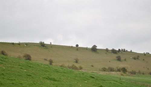
Visited the site today and found access very limited and could only get this shot taken from the village of Little Langford which it sits above.
Comments (0)
|
Add a comment
|
Permalink
Posted by
ginger tt
14th April 2010ce
Miscellaneous
Add miscellaneous
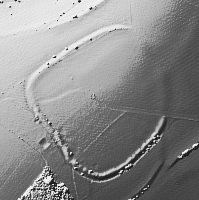
The remains of a large hillfort once defended by a triple line of ramparts. A single rampart survives.
Comments (0)
|
Add a comment
|
Permalink
Posted by
ginger tt
28th October 2009ce