The Modern Antiquarian
Log in
|
Register
Home
Latest Posts
Forums
Maps
Help
Browse Sites
News
Blog
Contributors
The Books
Select
-
Belgium
Denmark
Eire
France
Germany
Greece
Italy
The Netherlands
Norway
Portugal
Republic of Malta
Spain
Sweden
Switzerland
United Kingdom
England
Southern England
Wiltshire
Botley Copse
Long Barrow
Botley Copse (Long Barrow) on The Modern Antiquarian, the UK & Ireland's most popular megalithic community website. 1 image, plus information on many more ancient sites nearby and across the UK & Ireland.
Image © Robert Gladstone
Nearest Town:
Marlborough (14km WNW)
OS Ref (GB):
SU294599 /
Sheet: 174
Latitude:
51° 20' 12.77" N
Longitude:
1° 34' 40.48" W
Added by
Chance
Images (1)
0 discussions
Start a topic
Show |
Hide
Web searches for Botley Copse
Flickr
Google
Google Images
MAGIC
The Megalithic Portal
Bing
Stone Pages
Streetmap.co.uk
Wikipedia
Show map
(inline Google Map)
- Sites within 20 km -
-
Smay Down (1.74km E) (3 posts)
Tidcombe Long Barrow (2.41km S) (17 posts)
Tow Barrow (2.92km SW) (18 posts)
Crofton (4.1km WNW) (2 posts)
Fosbury Camp (4.27km ESE) (41 posts)
Grafton Disc Barrows (4.35km SW) (7 posts)
Kenward Stone (4.88km SSE) (14 posts)
Fairmile Down (4.96km SW) (21 posts)
Inkpen Hill (5.87km ENE) (2 posts)
Chisbury (6.23km NNW) (10 posts)
Bevisbury (6.62km SE) (3 posts)
Combe Gibbet (7.47km ENE) (13 posts)
Godsbury (7.92km WSW) (5 posts)
Walbury (8.05km ENE) (6 posts)
Easton Clump (8.32km WSW) (3 posts)
Square Copse Barrows (8.65km W) (1 post)
Savernake Lodge (9.08km WNW) (6 posts)
Summer Down (9.41km SW) (17 posts)
Mud Lane Barrow (9.45km W) (1 post)
Oldhat Barrow (9.6km WSW) (14 posts)
Savernake Temple (9.85km WNW) (1 post)
Savernake (9.95km WNW) (11 posts)
King Ina Earthworks (Eastern section) (9.97km SSW) (3 posts)
Ludgershall 1 (10km SSW) (7 posts)
Windmill Hill (Ludgershall) (10.12km SSW) (3 posts)
Ludgershall 2 (10.12km SSW) (7 posts)
Southly Bridge Barrows (10.39km SW) (5 posts)
Cow Down (Tidworth) (10.6km SW) (3 posts)
Giant's Grave (Milton Hill) (10.66km WSW) (18 posts)
Snail Down (10.8km SW) (6 posts)
Pickpit Hill Barrow (10.92km SSW) (2 posts)
Down Farm Group (11.13km WSW) (5 posts)
Weather Hill (11.41km SW) (9 posts)
Everleigh Barrows (11.69km WSW) (14 posts)
Forest Hill Farm (12.17km WNW) (5 posts)
Sidbury Hill (12.19km SW) (5 posts)
Weather Hill Long Barrow (12.21km SW) (1 post)
Martinsell (12.33km W) (22 posts)
Hot Cross Bun (12.56km SW) (4 posts)
Comesdeane Well Long Barrow (12.56km SW) (5 posts)
Pewsey (12.66km W) (9 posts)
Grant's Firs Group (12.76km WSW) (1 post)
Pewsey Church (12.97km W) (8 posts)
Giant's Grave (Martinsell) (13.18km W) (19 posts)
Weyhill (13.33km SSE) (2 posts)
Seven Barrows (Tidworth Camp) (13.49km SW) (5 posts)
Old Coach Road Barrows (13.67km SW) (3 posts)
Granham Hill (13.96km WNW) (2 posts)
Ballards Copse Long Barrow (13.99km NNW) (4 posts)
Dunch Hill Barrow (14.12km SW) (9 posts)
Marlborough Mound (14.13km WNW) (28 posts)
Huish Hill (14.21km W) (9 posts)
Lidbury Camp (14.3km WSW) (1 post)
Upper Woodcott Farm (14.44km E) (2 posts)
Barrow Copse (14.98km W) (30 posts)
Marlborough Common Golf Course Barrows (15.32km WNW) (3 posts)
Chisenbury Camp (15.39km WSW) (1 post)
Membury Camp (15.5km N) (32 posts)
Milston Down Long Barrows (15.74km SSW) (21 posts)
Barton Copse Barrows (15.78km WNW) (1 post)
Manton Round Barrow (15.81km WNW) (12 posts)
Swanborough Tump (15.86km W) (9 posts)
Broad Stones (Clatford) (15.91km WNW) (2 posts)
Aldbourne Blowing Stone (15.95km NNW) (6 posts)
Draycott Hill (15.96km W) (28 posts)
The Aldbourne Way (16.26km NNW) (1 post)
Ogbourne St Andrew Barrow (16.28km WNW) (23 posts)
Ogbourne St Andrew Church (16.28km WNW) (9 posts)
Balksbury (16.46km SE) (4 posts)
Milston Down Barrow Group (16.55km SW) (2 posts)
Beacon Hill (16.55km E) (26 posts)
Silk Hill (16.59km SW) (2 posts)
Clatford Barrows (16.65km W) (1 post)
Wash Common Barrow Cemetery (16.68km ENE) (8 posts)
Lockeridge Dene (16.77km W) (25 posts)
White Barrow (Lockeridge) (16.78km W) (1 post)
Picked Hill (16.89km W) (13 posts)
Golden Ball Hill (16.95km W) (13 posts)
Sheer Barrow (17.1km SW) (1 post)
Bury Hill (17.16km SE) (20 posts)
The Giant's Grave (Aldbourne) (17.2km NW) (21 posts)
Aldbourne (west of Giant's Grave) (17.27km NW) (8 posts)
Devil's Ditch (17.29km SSW) (8 posts)
Devil's Den (17.29km WNW) (126 posts)
Milston Down Firs (17.37km SW) (5 posts)
Seven Barrows (17.43km E) (9 posts)
Piggle Dene (17.53km W) (20 posts)
Knap Hill (17.63km W) (47 posts)
Aldbourne 'Cup Barrow' (17.78km NW) (2 posts)
Quarley Hill (17.86km S) (5 posts)
Aldbourne Four Barrows (17.96km NNW) (18 posts)
Knap Hill and Walker's Hill (18.14km W) (8 posts)
Gallows Barrow (18.18km SW) (6 posts)
Angle Down Barrow (18.18km E) (3 posts)
Knap Hill Pass (18.2km W) (2 posts)
Barrow Field Clumps (18.28km SSW) (4 posts)
Enford (18.28km WSW) (5 posts)
Knap Cottage Stone (18.33km W) (3 posts)
Adam's Grave (18.44km W) (69 posts)
Little Avebury (18.47km W) (20 posts)
Ogbourne Maizey Down Barrows (18.47km WNW) (2 posts)
Fyfield 1 and 2 barrows (18.5km WNW) (3 posts)
Ridgeway (Southernmost Remains) (18.54km W) (9 posts)
Woodborough Holed Stone (18.54km WSW) (6 posts)
Manton Down (18.56km WNW) (16 posts)
Ladle Hill (18.6km E) (9 posts)
Bulford Camp Barrows (18.66km SW) (1 post)
Alton Priors (18.67km W) (20 posts)
Brade Wyll (18.67km W) (3 posts)
Ladle Hill Disc Barrow (18.68km E) (4 posts)
Adam's Grave Fallen Stone (18.68km W) (5 posts)
Long Tom (Fyfield) (18.8km WNW) (11 posts)
Casterley Camp (18.95km WSW) (4 posts)
Aldbourne 7 (18.95km NW) (4 posts)
Laundry Bungalows (18.96km SSW) (1 post)
Warren Farm (18.97km NW) (2 posts)
Down Barn standing stones (18.98km W) (5 posts)
East Kennett (19.03km W) (60 posts)
White Horse Barrow (19.05km W) (11 posts)
Pickledean Stone Circle (19.09km W) (12 posts)
Fyfield Down settlement (19.14km WNW) (4 posts)
Harestone Down Stone Circle (19.14km W) (25 posts)
The Mother's Jam (19.2km WNW) (22 posts)
Temple Bottom (19.2km WNW) (4 posts)
Harestone Down barrow (19.23km W) (3 posts)
Sugar Hill (19.24km NW) (10 posts)
Monster Stone (19.25km WNW) (7 posts)
Overton Hill (19.28km W) (113 posts)
Fyfield Down (19.29km WNW) (22 posts)
Borough Hill (19.31km NE) (3 posts)
The Hanging Stone (19.44km W) (6 posts)
Watership Down (19.52km E) (1 post)
The Sanctuary (19.59km W) (80 posts)
Experimental Earthwork (19.62km W) (10 posts)
Wilbury House (19.67km SSW) (2 posts)
Overton Down (19.78km WNW) (20 posts)
East Garston Ditch (19.79km NNE) (14 posts)
Whitefield Farm (19.88km WNW) (1 post)
- Facilities within 20 km -
-
Marlborough Tourist In... (Tourist Information: 13.7 km WNW)
Raj Indian Restaurant (Restaurant: 14.2 km WNW)
The Museum of the Iron... (Museum: 15.8 km SE)
Andover Museum (Museum: 15.8 km SE)
Foxlynch (Camping Site: 17.5 km NW)
The Old Forge (Bed & Breakfast: 19.2 km WNW)
The Barge Inn (Pub: 19.3 km W)
- Add -
-
Add news
Add an image
Add fieldnotes
Add folklore
Add miscellaneous
Add a link
-
Add a site
Add a nearby facility
Add an alternative name/spelling
Images
(click to view fullsize)
Add an image
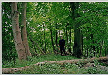 Image © Robert Gladstone

