Chance

Chance

All posts 1,951-2,000 of 2,683 posts

Festival of British Archaeology Events

Several events on and in the Dartmoor area as part of the Festival of British Archaeology – 17th July to 1st August 2010


Going for Bronze – Dartmoor’s Bronze Age
Sat 17 July-Sun 1 Aug
High Moorland Visitor Centre, Princetown,
Yelverton, Plymouth

Visit this exhibition which defines the many changes which happened during Dartmoor’s Bronze Age.

Dartmoor National Park Authority & Royal Albert Memorial Museum – 01822890414
[email protected]


Brimpts Tin Mines, Dartmeet – a Short Guided Walk
Thu 29 July 14.00 – 16.00
Brimpts Farm, Dartmeet, Dartmoor

Guided walk around part of Brimpts Tin Mines Trail, led by volunteers who have worked on conserving this fascinating site.
All welcome, stout footwear needed.

Dartmoor Tinworking Research Group – 01752 696257
[email protected]
www.dtrg.org.uk


Bronze Age on Dartmoor
Wed 11 Aug 10.30-12.30 & afternoon guided walk
Jubilee Hall, Cross Tree, Chagford, Newton Abbot

Activities to bring alive the life and culture of Bronze Age people on Dartmoor and an exploration of a local Bronze Age settlement and ritual site with an experienced guide.

Royal Albert Memorial Museum – 01392 665780
[email protected]
www.exeter.gov.uk/RAMM


Bronze Age Life and Landscapes
Wed 28 July 10.30-12.30 & 13.30-15.30
Exeter Cathedral Chapter House

Explore Bronze Age culture with special reference to sites on Dartmoor.
A partnership between RAMM and Dartmoor National Park.

Royal Albert Memorial Museum – 01392 665780
[email protected]
www.exeter.gov.uk/RAMM


Wayside Marker Stones on Dartmoor
Tue 27 July 10.00 – 14.00
Meet at car park on Whitchurch Down

A guided walk along old tracks and highways on the western flank of Dartmoor, passing ancient stone crosses and turnpike
milestones that informed earlier travellers.

Dartmoor National Park & Milestone Society – 013922 77271
[email protected]


Archaeological Guided Walk around Cox Tor, near Princetown
Sat 17 July 14.00 – 16.00
Meet at Pork Hill car park

Guided walk of Cox Tor, looking at archaeology, and visiting the DPA cairn survey and repair team at work. All welcome, stout
footwear needed.

Dartmoor Preservation Association – 01752 696257
[email protected]
www.dartmoorpreservation.com

Link

Cornwall
Cornish Ancient Sites Protection Network

The Cornish Ancient Sites Protection Network is a charitable partnership formed to look after the ancient sites and monuments of Cornwall.
They work closely with local communities and official organisations to protect and promote the ancient heritage landscape through research, education and outreach activities.

Tumulus du Montioux

Tumulus du Montioux – Sainte Soline

Visited 15 September 2008

This was the final site we visited in the Poitiers region and the nearest to Chaunay where we were staying. The site lies south of Poitiers on the N10 by Chaunay. Turn right at Chaunay then take the D55 to Str-Soline. Turn right again to Bonneul and the site is in a field on the left.

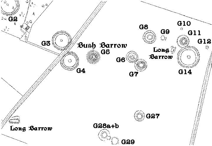
The site is sign posted; and was partly excavated in 1995. It dates from the bronze to Iron age (1800 – 500 BC).Finds include ceramics, flint tools and a sepulchre was discovered under a stone slab. The site consists of a single, unexcavated round barrow and a 50 m long mound with four funeral chambers. See site plan. These date from the Angoumois period and have an Atlantic type layout with a 11 m long corridor with polygonal Cambers.

The walls of the access corridor are composed of pillars alternating with dry stonewalls, but unlike West Kennet Long Barrow, the end chambers have been left open so the feeling of a confined space is lost.

The oldest of the group appears to be the unexcavated round barrow.

Folklore

La Pierre-Levée (Poitiers)
Burial Chamber

The Venerable Bitard and the Big Penis Videos

La Pierre Levée seems to have become entwined with Poitiers and this is recorded in the various legends and folklore connected with, and still lived out on the site.

One legend says that St. Radegonde , who is buried just over the river in …glise Ste-Radegonde, brought the huge capstone block on her head and the pillars in her apron. The church of Ste-Radegonde can be seen in the background on the 18th c. print of La Pierre Levée from Monuments Druidiques.

The other, more famous folklore comes from the writings of François Rabelais (c. 1494 – April 9, 1553) who was a major French Renaissance writer, doctor and Renaissance humanist. He has historically been regarded as a writer of fantasy, satire, the grotesque, and both bawdy jokes and songs.

Rabelais studied at the University of Poitiers and wrote The Life of Gargantua and Pantagruel (in French, La vie de Gargantua et de Pantagruel).

This is the story of two giants, the father (Gargantua) and his son (Pantagruel) and their adventures, written in an amusing, extravagant, satirical vein. There is much crudity and scatological humour as well as a large amount of violence.
Pantagruel was said to have snatched La Pierre Levée from a local cliff face and placed it in the Dunes, turning it into a banquet table for local scholars who, ‘when they have nothing else to do, pass the time by climbing up onto the stone and banqueting there with large quantities of bottles, hams and pastries, and inscribing their names on the capstone with a knife’. This was illustrated as early as 1561 in Georg Hoefnagel’s “Civitates orbis terratum”

Well things have moved on since then and every year around the spring equinox, a week long festival takes place called the 69th Student’s Semaine. This is overseen by the Bitards, a brotherhood of alcohol enthusiasts who keep alive the infamous Bitardbourg . Activities take place every day, such as the drunken parade to and from La Pierre Levée in honour of Pantagruel. Some of this material is for adults only but for a taste here is the big penis 2007

The Venerable Bitard (LST!)

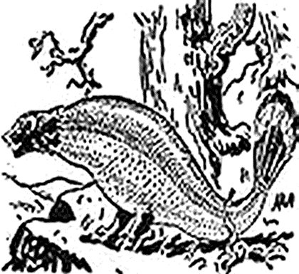
The demigod of estudiants Poitiers has its origins in ancient times, when gods lived on Olympus. Juno, wife of Jupiter, leaped one day with a shepherd. The anger of her husband must have influenced the destiny: she gave birth in pain. His offspring was a monster head weasel, body of carp, turkey feathers, peacock feathers, wing rails and academic honours. This being, God by his mother, was the revered Bitard (LST!). But Juno, horrified by the sight of her divine child, hurled him over mountains and valleys. The latter fell in the forest of Liguge. For many miracles, he made known his divine nature to the natives. They paid him a cult and fought a shrine in his honor. In the fifth century, St. Martin converted many natives to their religion. The shrine became a convent. But insiders, rejecting the new ideas, fled into the woods with the relics of revered Bitard (LST!). They taught their religion to their children. Thus, over the centuries, their mysteries were sent to dignitaries of the Order of the revered Bitard (LST!). The cult is still celebrated “schoolboys faithful” at night and secret meetings which are allowed the dignitaries.
In addition, every year, around the spring equinox, the heart of a large gathering in the forest of Chanteloup, estudiants, guided by the College, engaged in hunting Bitard (Praised be He!) then back to Poitiers for the new Grand Bitardier through the city.

La Pierre-Levée (Poitiers)

La Pierre-Levée (Poitiers) – Fieldnotes

Visited September 14th 2008

My hosts had set aside a Sunday afternoon for the exploration of Poitiers. Having owned a local property for over twenty years, they had shown numerous visitors around it’s ancient streets, cathedral and past Aquitaine splendours. It came as some surprise when I asked to visit the megalithic remains, as they didn’t know of any.

Poitiers was founded by the Pictones tribe and their fortified centre or oppidum was named Lemonum, Celtic for elm, Lemo. Although the Pictones assisted Rome and accepted Roman control when Caesar defeated the Gaulic tribes at the decisive battle of Alesia in 52 B.C., Lemonum became the scene of resistance and it’s oppidum was raised to the ground. Although La Pierre-Levée escaped this destruction, the might of Rome was to be felt alongside it with the construction of the major road from Lemonum (Poitiers) to Avaricum (Bourges) and onto Lugdunum (Lyon). When Poitiers became the capital for the roman province of Gallia Aquitania, aqueducts, baths and a vast amphitheatre, larger than the one at Nîmes, were constructed Unfortunately this was destroyed in 1857 during a period of “modernisation” of the city. Remains of Roman baths complex, built in the 1st century and demolished in the 3rd century, was uncovered 1877 and led to a more civilised conservation approach to the city’s antiquities and history. In 1879 a burial-place and tombs of a number of Christian martyrs, hypogee martyrium were discovered on the heights to the south-east, the names of some of the Christians being preserved in paintings and inscriptions.

La Pierre Levée is located outside the old city walls in the district known as the Dunes. This lies across the river by Le Pont Neuf, which is the start of the old Roman road to Lyon (N151). If following this road into the city, when it becomes the Rue de la Pierre Levee, turn right at the cross roads with Rue du Dolman and the Pierre Levée is in front of you. If travelling out of the centre on Le Pont Neuf, you will need to turn right onto Allee du Petit Tour and then cross over Rue de la Pierre Levee onto Rue du Dolman. La Pierre-Levée is a cultural icon of the city and is well sign posted. La Pierre-Levée lies south-east of the city in the Dunes. Its sandy soil would have yielded poor crops and seems to have been set aside by the Pictones for the revered ancestors. A short distance away is the hypogee martyrium which is also a pre-roman sacred site.

La Pierre Levée means the raised stone or rock and is 22 feet (6.7 m) long, 16 feet (4.9 m) broad by 7 feet (2.1 m) high with a rectangular chamber. The large capstone sits on several supports along the southern side, but is broken and falls to the ground at the northern side. This damage apparently happened in the 18th Century, but facts are unclear as to what caused it. There are accounts of several stones, presumably the “pillars” which held up the northern side, being removed from the site and taken into the city. The site is mentioned in various records from the Middle Ages, with its Latinized name in different ways: Petra-Levata in 1299, Petra-Soupeaze in 1302, Petra-suspense in 1322. The Charter of 1302 also indicates its position: Super dubiam, the Dunes.
Church records indicate that the site was used as a public meeting place and several festivities were held here including the great fair of Saint Luke. The city prison used to stand behind the site but this was demolished after WWII and the area redeveloped.

Image of La Pierre-Levée (Poitiers) (Burial Chamber) by Chance

La Pierre-Levée (Poitiers)

Burial Chamber

La Pierre Levée as a banquet table for local scholars who, ‘when they have nothing else to do, pass the time by climbing up onto the stone and banqueting there with large quantities of bottles, hams and pastries, and inscribing their names on the capstone with a knife’. Illustration from 1561 in Georg Hoefnagel’s “Civitates orbis terratum”

Image credit: Georg Hoefnagel - 1561
Image of La Pierre-Levée (Poitiers) (Burial Chamber) by Chance

La Pierre-Levée (Poitiers)

Burial Chamber

Legend says that St. Radegonde , who is buried just over the river in Église Ste-Radegonde, brought the huge capstone block on her head and the pillars in her apron. The church of Ste-Radegonde can be seen in the background on the 18th c. print of La Pierre Levée from Monuments Druidiques.

Image credit: Unknown - From Monuments Druidiques

Hypogée Martyrium

Hypogee Martyrium – Fieldnotes

Visited September 14th 2008

The Hypogee Martyrium lies a short distance from La Pierre-Levée in the Dunes suburb of Poitiers. The area would appear to have been set aside by the Celtic Pictone tribe for their revered ancestors, if not their deceased.

The ancient heart of this half-buried tomb was only unearthed in 1878 by Father C. La Croix. Notarial and oral tradition had preserved the memory of this field “Chiron martyr” or a “path of martyrs”. In exploring the necropolis, Father C. La Croix. discovered it contained exceptional carvings and inscriptions from the very early Christian period. It would appear that the site had been a place of worship since the Neolithic period and then used by the first Christians before Christianity was adopted by the Roman Empire. The tomb contained the martyred remains of some of these persecuted Christians, together with their earlier pagan companions.

Although we found the Hypogee Martyrium, there was an official notice informing us that the site had been closed to the public by municipal decree on October 5, 1998. It would appear that the museum service of Poitiers had decided the site was in need of restoration and had closed it until this could be carried out. I had to make do with taking a few pictures from outside the gates.

Further information and pictures of the interior can be found on the official museum service web site, along with a tourist guide for the site from 1911.

Image of Pierre du Sacrifice (Burial Chamber) by Chance

Pierre du Sacrifice

Burial Chamber

An ancient legend tells of the “petits hommes”, the little people who were said to inhabit the forest. They were said to have built the tumulus and made it there home. They were so strong that they could carry the enormous 15 tonne blocks with their bare hands.

Image credit: M.Gomez De Soto

Folklore

Pierre du Sacrifice
Burial Chamber

The information board gives two legends associated with this destroyed tumulus.

The first, and the source of the “Sacrifice” tag, suggests that the straight groove formed along the middle of the stone was used “aux sacrifices rituels et a la magic noire”, (for sacrifice rituals to do with black magic). Presumably the “victim” was sacrificed upon the stone and the blood would be collected as it dripped down the groove into a cup or chalice. This would point to the stone being in a more or less flat position when the tumulus was intact, possibly forming part of the capstone or roof.
The groove is hardly natural and does not travel the whole width of the stone. See enclosed photos. There was record of a Sheppard’s crook or Crosse being carved into one of the upright stones too. Whether this was ancient or done in the later Christian era is unclear, as is also if it survived the 19th century destruction. Maybe it was carved by the church authorities in order to “sanctify and purify” a pagan relic.

A much more ancient legend tells of the “petits hommes”, the little people who were said to inhabit the forest. They were said to have built the tumulus and made it there home. They were so strong that they could carry the enormous 15 tonne blocks with their bare hands. Maybe they were the faries and they could move the huge stones using their magic.

Pierre du Sacrifice

Pierre du Sacrifice (Boixe A) – Fieldnotes

Visited September 13th 2008

Came to the Forêt-de-Boixe at the end of a long hot day travelling around Charente with some English friends who owned a house in the region. These were normal, non-megalithic folk and were more interested to walk in the forest then looking at barrows or discarded old rocks. We parked up at the side of the road, just off the D18/D116 and as a consequence missed the official car park along with the information board giving details of the monuments, site layout and the history of the forest.

While the rest of the party headed off down the main track to the large clearing in the Chalet Boixe, I scouted around the forest looking in vain for the main tumulus, the Tumulus de la Boixe. After getting disorientated (I’m only told to get lost), I retraced my steps and came upon a little wooden sign saying Dolmen. Thinking this was the Tumulus de la Boixe, which was said to be 30m in diameter and 3m high, I was expecting to come out into a sizable clearing in the forest. Alas the primary objective of the mission was not to be and I had to contend myself with the secondary one in the shape of the Pierre du Sacrifice.

This stone is impressive though being around 4 metres long, 2 metres wide and about 1 to 1.5 meters in thickness. The official national de forest have provided an information board with some interesting facts about it, and artist impressions of the tumulus it came from. Apparently this was, until fairly recently, the largest tumulus in the area, measuring 45 metres in diameter, and standing 4 metres high with a circumference of 140 meters. The board then goes on to say that the tumulus was destroyed in the 19th century during construction of the D18 Mansle to Saint Amant de Boxie road, although this road was originally the old Roman road from from Périgueux to Poitiers called Chaussade Shod or path. Maybe the tumulus was destroyed for its building material when the road was “improved” and this stone was considered to be “cursed” and so is all that remains. See the section on additional folklore which is included below for more on this.

Tumulus de la Boixe

Tumulus de la Boixe – Fieldnotes

Almost visited September 13th 2008

Although I came very close to visiting this site, we parked on the wrong side of the road and missed the offical car-park and the Tumulus completely. See fieldnotes for the Pierre du Sacrifice for the full story.

This site has been now been included on the TMA Google Earth so check it out before visiting and you won’t make the same mistake as I did.

Image of Charente (16) (Departement) by Chance

Charente (16)

Departement

View looking East from the village of Tusson. The top of the ridge contains four huge tumuli, including Le Gros Dognon, running in a line north south. The arrow is pointing to La Justice tumulus.

Image credit: Chance - Sep 2008

NT Press Release, Avebury Summer Solstice

National Trust Press Release

Issued 8 June 2010

Avebury Summer Solstice

Campers planning to visit Avebury for the summer solstice are being warned that there will be less space for tents than last year, following the loss of a field for camping.

The National Trust has arranged for a field which can accommodate a little under 100 tents. Last year they had negotiated permission to use a field of twice the size, but its use this year was withdrawn and the Trust has been working with village residents and Pagan groups to find a solution, but no additional land could be found

Hilary Makins, the National Trust Avebury Head Warden, said the solstice celebration was expected to be busy.

“We have looked at many options for camping during the solstice but since Avebury is a World Heritage Site land options are very limited. We want people to come and enjoy a peaceful solstice but also to consider using some of the other official campsites nearby, or perhaps just making a short trip for the main celebrations to save having to camp overnight.”

The campsite, at the far end of the main public car park in Avebury, will open at 9am on Saturday 19th June. Celebrations will take place in the Avebury Henge over the weekend, culminating with the sunrise on Monday 21st. The campsite closes and must be cleared by 2pm on Monday.

The National Trust is part of the Avebury Solstice Planning Group which has, over many years, developed a plan to ensure the solstice at Avebury is a peaceful celebration.

“We work closely with police, the local councils, residents, the fire brigade and other safety groups to ensure that this is a pleasant event for those who wish to celebrate the solstice here,” added Hilary.

“With this year’s event on the weekend, we know it will be busy but we hope people will be aware of the restrictions on camping and make arrangements either to use official campsites nearby or to book other local accommodation.”

Ends

For further press information contact:
Allan King, 01985 843592 or 07771 837988, [email protected]

Miscellaneous

Vienne (86)
Departement

Accounts on some prehistoric antiquities in the departments of the Vienne and Charente, France.
by A. L. Lewis officer d’ Academic.

The following particulars were collected by me, while attending the meeting of the Congress prehistoric de France, held at Angouleme in August 1912, at which I had the honour of representing the Royal anthropological Institute by request of the council.

There is a fine Dolman, near Poitiers; it is called the “Pierre Levee” and tramcars run from the hotel de Ville past the prison, at the back of which the Dolman stands in a garden at the corner of two roads. The capstone is about 15 feet in extreme length and breadth, and a further length of 4 feet, apparently broken off, lies on the ground at the north east end. The bearings are nearly north-east and south-west; there are the remains of seven supporters, forming originally a chamber, 10 feet wide from northwest to southeast, and 7 feet or 8 feet from north-east to south-west. Of these supporters, two at the south-west end are from 5 feet to 6 feet high, but those are the north-east have fallen and let that end of the capstone down to the ground, so that without excavation it is not possible to say whether another chamber existed there or not. The capstone is nearly 3 feet thick, and on the top of it, near the north corner, are a remarkable boss and ridge.
In the Foret de Boixe, near Vervant, there is a remarkable monument called le Gros Doignon. It consists of a tumulus with a large capstone supported by other stones. On getting down under this stone through a narrow opening, one side of the space beneath it is found to consist of a wall with a large carefully squared opening through it communicating with another rectangular chamber, which is completely covered by the tumulus. Whether this is a later addition, and if so, when it was constructed, I do not know; but when Richard wrote his France Monumental sixty or seventy years ago its existence was apparently unknown, and the only the capstone was to be seen.
About 6 km north from this monument there are were formerly five dolmens, of which only two remain, these are called the great and little Perottes, and stand about 165 feet apart in a line 25 degrees east of north. The great Perotte, which is to the south, consists of a very regular and nearly rectangular chamber 10 1/2 feet internally from north-west to south-east, 9 feet from north-east to south-west, and 6 feet high. Three of the sides have three supporters each, and the fourth (South West) has four; one of the north-east side has been forced inward, and the gap thus made forms the present entrance; one next to it, on the north corner, has sculptured upon it the representations of two stone axis. The capstone is nearly 18 feet long by 13 1/2 feet wide, and from 6 to 8 feet thick. There are other stones, two of which are of great size, and also remains on the tumulus surrounding the chamber.
The Little Perotte is small only by comparison, the capstone being about 14 feet long by 8 1/2 feet wide and 4 feet thick. It has, however, remains of only five supporting stones, but there are what seem to be two smaller capstones covering an entrance passage, or it may be another chamber, on the south-east side. The longest axis of the dolman itself is 25 degrees east of north and west of south. Several stones are scattered about near the two Perottes, which are no doubt remains of other monuments. The material was said to be coralline limestone with terebratula, &c., brought from Chateau-Renand, 3 kilometres distant.
Richard (France Monumental) describes three other dolmens in the neighbourhood, which I suppose were those mentioned to the Congress as having been destroyed.


A. L. Lewis officer d’ Academic
Man, Vol. 14, (1914), pp. 40-42 Published by Royal Anthropological Institute of Great Britain and Ireland


While travelling through France and Switzerland in September 2008, I visited some of the sites mentioned, these being in the Department of Vienne , La Pierre-Levée (Poitiers) and in the Department of Charente , La Grosse Pérotte and it neighbour La Petite Pérotte. Charente is also home to the Forest of Boixe, near Vervant, and although I did not visit the Le Gros Doignon, I did find the capstone from one of the other destroyed monuments in the forest, the aptly titled Pierre du Sacrifice , whose destruction was also mentioned.

Miscellaneous

Lake Group Earthwork
Ancient Village / Settlement / Misc. Earthwork

The reason this Bronze Age earthwork survives as well as it does is mostly due to it still acting as a boundary between two fields and so has not suffered the plough. A lot of the linear archaeology in the Stonehenge area was flattened by mediaeval ploughing but this well-preserved section of boundary bank and ditch across Wilsford Down has survived and is clearly visible within the modern landscape, both from the ground and the air.

See the detail from the 1810 map of the area by Colt-Hoare for a clearer idea of how this feature fitted into the barrow groups in the area.

Another bank, only intermittently preserved, runs north-westwards from the wood in the Lake barrow group, up to the Winterbourne Stoke barrow group at the junction of Longbarrow Crossroads with the A303. This may have originally been created as a boundary between the two massive Long barrows, each being the centre of the barrow grouping.

Image of Lake Group (Round Barrow(s)) by Chance

Lake Group

Round Barrow(s)

The Lake group Long Barrow is aligned north-west to south-east, stands 2.5 metres high, is 42 metres long and 23 metres wide.
Records suggest it has never to have been opened or excavated in any way.

Image credit: Chance - Aug 2007