
Plan made by Mr. Croker, for Sir R. C. Hoare, with corrections by Sir Gardner Wilkinson – 1826
Image credit: Mr. Croker - 1826

Plan made by Mr. Croker, for Sir R. C. Hoare, with corrections by Sir Gardner Wilkinson – 1826

Ste-Madeleine dolmen located at St Germain-sur-Vienne, near Confolens, in Poitou.
A dolmen raised up on Romanesque design, twelfth-century pillars, sited on an Island in the Vienne River. The cap-stone, measures 12 feet by 15 feet, and is of proportionate thickness. The mass was originally supported by five columns but one having fallen away, it now rests only on four. The site was translated into a Christian chapel dedicated to saint Madeleine and is also known as Pierre Madeleine or Dolmen de la Chapelle

The sarsen stones at Ashdown from a drawing by A.L. Lewis – 1853
The Fairy Music
THE evil influence of the fairy glance does not kill, but it throws the object into a death-like trance, in which the real body is carried off to some fairy mansion, while a log of wood, or some ugly, deformed creature is left in its place, clothed with the shadow of the stolen form.
Young women, remarkable for beauty, young men, and handsome children, are the chief victims of the fairy stroke. The girls are wedded to fairy chiefs, and the young men to fairy queens; and if the mortal children do not turn out well, they are sent back, and others carried off in their place.
It is sometimes possible, by the spells of a powerful fairy-man, to bring back a living being from Fairy-land. But they are never quite the same after. They have always a spirit-look, especially if they have listened to the fairy music. For the fairy music is soft and low and plaintive, with a fatal charm for mortal ears.
Ancient Legends, Mystic Charms, and Superstitions of Ireland By Lady Francesca Speranza Wilde
A huge collection of folklore and folk-magic from Oscar Wildes’ mother.
View online at Google Books, Sacred-texts Com, or download this collection for your iPhone or iPod.
Report of John Thurnam’s 1861 examination
Download the complete book in pdf format
Archaic sculpturings of cups, circles, &c. upon stones and rocks in Scotland, England and other countries
Sir J. Y. Simpson, Bart., M.D., D.C.L. – 1867
Download the complete book in pdf format
The ancient British, Roman and Saxon antiquities and folk-lore of Worcestershire By Jabez Allies F.S.A. 1852
Download the complete book in pdf format from Google books
A concentric circle of standing stones, similar to the Sanctuary, located next to and under the M4 at Fir Clump.
The site was surveyed by Mr. R H Reiss, who recorded its measurements as 107m x 86.5m. The outer ring was fragmentary but enough remained of the inner ring to see that it was flattened to the north and measured 86.5 x 73.7m.
About 125m to the west of the circle was a single row of stones aligned NNW-SSE. This was recorded as being 102m long.
Although the site was destroyed during the construction of the East bound M4 Motorway in 1973, some of the stones are said to survive within the vegetation beside the M4 and the current golf course..
The site was classified as Neolithic, given the title Fir Clump, Burderop Wood and listed on the Wiltshire sites and monuments record as SU18SE117

West Kennet Long Barrow as excavated in 1859 by Dr. Thurnam. These excavations took the form of lifting the cap-stones of the chamber, excavating the material on the floor of it, and similarly clearing about fifteen feet of the passage, working outward from the chamber. These diggings leave much to be desired (no plans or sections of the burial deposits were made) and it is fortunate that no attempt was made to clear the outer end of the passage or the entrance forecourt. This plan made at the time by W. C. Lukis.

Plan of long barrow prior to it’s destruction in 1955
The Manton Down Long Barrow (Neolithic Wessex Map, No.11).
This tomb, sometimes referred to as Doghill Barrow, was again noted by Aubrey, though not I believe by Stukeley, and it received passing mention from Colt Hoare. It is here planned for the first time and is a short oval cairn (with no trace of side ditches) about 60 by 35 feet. At the south-east, higher, and slightly broader end, are remains of a small rectangular chamber, two stones of which remain upright, while others are prone beneath the fractured capstone, which leans on the remaining upright of the south-west side. The dimensions of the chamber are uncertain, but its internal measurements can hardly have been more than six feet square. There is one outlying stone at the southern corner of the mound which may be the remains of a peristalith otherwise vanished—Colt Hoare observed that in his day ” the mound appears to have been set round with stones”, and some remained until about 1913. The small squarish chamber opening more or less directly on to the facade is paralleled in the Cotswolds at, for instance, Randwick, while St. Nicholas (Glam.) is not dissimilar. In Dorset, the Grey Mare and her Colts seems to have an analogous plan, though here access to the chamber must have been made from the side. At Manton it is difficult to judge without excavation, but a frontal entrance seems reasonable to assume from the stones as they now remain.
Notes on some North Wiltshire chambered tombs
By Professor Stuart Piggott F.S.A.
W.A.M. 52 Page 60-61 – 1946
An unrecorded Long Barrow at West Kington.
Between West Kington village and Tormarton the county and parish boundaries run parallel and south of the Burton—Bristol Road ; on this is milestone 12 from Christian Malford ; 475 yards S.W. of this and just south of the road is an unrecorded long barrow discovered by the writer in February, 1939. It is a green mound, noticeably rectangular with square but slightly rounded ends, still standing seven feet high at a point east of the centre. It is 150 feet long by 57 at the S.W. end and just over 60 at the N.E.; its direction is 40 degrees magnetic. Three parts of the barrow are in fine preservation but the N.E. end being in another field has been somewhat ploughed down but is still some feet high and well defined. A hedge passes over it at 45 feet from its termination in that direction. There are no signs of side trenches.
To the north there is a field wall by the road side and a small excavation has been made in the N.W. flank of the barrow for wall stone but it is merely a shallow hollow which has caused very little damage. At the S.W. corner there is a very curious small outwork not connected with the barrow but almost touching it, which is hard to explain.
Close to this spot the six inch O.M. Wilts Sheet XVIII, N.E., marks two small round barrows, Goddard’s No. 1 and 2, West Kington. There is however no trace of these mounds now and it is doubtful if they ever existed. But in tlie next field in its W. corner and close to the head of the long barrow is a small barrow ploughed very low hitherto unrecorded. Over the road to the N. are two round barrows now ploughed very flat. To the E. is a round barrow, Goddard No.3 West Kington. This is a low bowl-shaped mound opened at top, about 50 feet in diameter and three and a half high. It differs from any barrow I have ever seen by having a platform on its S. side, apparently part of the barrow.
A. D. Passmore 1939
W.A.M. Volume 48 – page 466
Morgan’s Hill is so named after a Mr. Morgan of Heddington who murdered his uncle. For this he not only hung but his body was left hanging on the hill top gibbet.
Gibbeting was common law punishment, which a judge could impose in addition to execution. This practice was regularised in England by the Murder Act 1752, which empowered judges to impose this for murder. It was most often used for traitors, murderers, highwaymen, pirates, and sheep-stealers, and was intended to discourage others from committing similar offences.
As was the case with murderers, he was not given a Christian burial in a church yard but what was left of his remains were placed face down and covered with stones. In Morgan’s case, this was somewhere on the parish boundary between Heddington and Bishop Cannings, probably just over the road from Smallgrain Plantation. It would appear that the spot contains several bodies of highwaymen too, but none of the infamous Cherhill Gang who robbed the stagecoaches naked, for none was ever caught.
This tale told to me by the late Mr. Atwell of the motor museum who was shown the very spot while out horse riding “on the same day they buried Winston Churchill”.
The Murder Act 1751 (25 Geo.2 c.37) was an Act of the Parliament of the Kingdom of Great Britain.
The Murder Act included the provision “for better preventing the horrid crime of murder”,“that some further terror and peculiar mark of infamy be added to the punishment”, and that “in no case whatsoever shall the body of any murderer be suffered to be buried”, by mandating either public dissection or “hanging in chains” of the cadaver. The act also stipulated that a person found guilty of murder should be executed within 2 days of being found guilty unless the execution would happen of a Friday in which case the execution should take place on the Saturday.
The Murder Act – Repeal date: 18 July 1973
The Black Legend
The black legend is the tale of forbidden love, a femme fatale, exposed passion and a multiple murder.
Crafted by a Hollywood icon into a 1940’s silent black and white movie, the story told by a young John Schlesinger and Alan Cooke contains the same sinful mix of ingredients found in such film noir classics like The postman always knocks twice.
Unlike the pulp fiction penned by Raymond Chandler, this eternal triangle of temptation, lust and homicide, was not played out on the backstreets of some depression hit U.S. city, but on top of the highest and most sacred hill on the Wiltshire Berkshire border.
After 333 years of damnation, have the murdered or murderers’ found peace in this ancient landscape?
As with any tale that has become legend, sorting fact from fiction is not straight forward. Many variations on the same theme have grown up and with the script writers hand at work, aspects may have been lost in the mix, added to or completely created. The tale I will now tell may not be the whole story but I shall attempt to be as honest and direct as can be construed.
Travel back in time to a cold winters day in the year 1676, the 23rd of February 1676 to be precise. The place is Winchester Assizes where a farm labourer named George Bromham and a widow named Dorothy Newman are standing trial for murder. The record of the trial is to be found in the Western Circuit Gaol Book for the period XXII-XXIX Charles II, the exact chapter XXVIII Ch.II, is retained in Winchester Library. George Bromham was a farm labourer living in the tiny village of Combe, just below Walbury Hillfort on the edge of Berkshire. He was married to Mrs. Martha Bromham and had a young son, Robert. It would appear that George Bromham had formed some kind of illicit association with the widow Dorothy Newman who lived in the larger village of Inkpen, a few miles over the other side of Walbury Hillfort, in the valley below.
It is not stated how long this relationship had been formed or what brought the two together or even if the relationship was “village gossip”. What is clear is that one dark day in the weeks leading up to the trial, Martha and her son Robert were walking the ancient Wigmoreash Drove which connects Inkpen and Woodhay to the top of Inkpen Beacon and Combe. Either George or both George and Dorothy were lying in wait, and beat Martha and Robert to death with a “staffe”. Whether both committed murder or not, the beaten bodies of Martha and Robert were dumped into the dew pond known as Wigmoreash Pond or as it became known “Murders’ pool”.
The tale now twists with the addition of a character called “Mad Thomas”. Thomas is said to have been the village idiot and either deaf , dumb or both. It was Thomas who is said to have witnessed the dastardly deed and altered the authorities to the bodies and the culprit(s). Indeed Thomas is said to have been called as a witness at the Assizes. Whether this was fact or fiction is unclear, it may have been written into the film’s script for convenience, the guilty party(s) may have been brought down by other factors such as tracks in the snow or mud, the murder weapon(s), blood stained clothing, village gossip or a guilty confession.
Whatever or whoever it was that pointed the finger of suspicion at George Bromham and Dorothy Newman, both were haled off to the Assizes at Winchester, both stood trial for the murder of Martha and her son Robert, both were convicted and found guilty of murder and both were ordered to be hanged “in chaynes near the place of the murder”. Their public hanging took place on 3rd March 1676 in Winchester.
Records suggest that some dispute arose as to who would be liable for the cost of the “hanging in chaynes”, which would involve the building and erection of a considerable sized double gibbet, together with two sets of iron “chaynes”. As the crime was neither committed, or planned in either the parish of Combe or Inkpen, but on their borders. This was settled by the cost being equally split between both parishes and the place that neither parish had claim to as the boundary stopped at the side ditches, the Long Barrow itself. Records indicate that the two dead bodies were then brought back to Inkpen and laid out in the barn at the back of the Crown and Garter Inn, where they were measured up by the local blacksmith and fitted in their chaynes. This barn is reputed to have became a tourist attraction, probably initiated by the landlord, and was renamed ‘Gibbet Barn’. It would appear that the final hanging of the bodies of George and Dorothy, now bound in their chaynes, took place each side of their double gibbet on the 6th day of March 1676.
The original gibbet lasted an unknown length of time, but the second gibbet was erected in 1850 to replace the rotted original. This was struck by lightning, and was replaced by number three in 1949. It is unclear if this was a `prop’ used in the film. However, that one lasted only one year, and number four was erected in 1950. Since then the gibbet has been sawn down by vandals on two occasions, in 1965 and 1969, both events believed to have been in protest against hanging. The fourth gibbet blew down in gales during the winter of 1977-78, where the stump had rotted away. The current gibbet was re-erected on May Day, Beltane, 1st May 1979.

Tumulus, with fallen Cromloch near Littleton-Drew, Wilts from a sketch taken in 1821
A mass pile up on the A303? Carnage at the summer solstice? Visitor centre gets vacuum cleaner sponsor?
Oh my God, Ziller! – Monday 12th July @ 8 p.m. sees the UK premier of the SYFY movie, Stonehenge Apocalypse (2010)
When a group of archaeologists dig up a human skeleton near the historical monument of Stonehenge, an ancient piece of machinery hidden beneath the bedrock is discovered. Not knowing what it could be the workers accidentally trigger the mechanism and start a chain of events that may very well end the world as we know it...
For spoilers and reviews see – imdb.com/title/tt1488598/
Warning: This film clashes with university challenge in which a team from Cardiff take on Brookes University, Oxford
A Lecture given to the Woolhope Naturalists’ Field Club, at Hereford, September, 1921, by Alfred Watkins
Download complete book in pdf format
Web site for the Dartmoor preservation association who own three areas of land within the Dartmoor National Park, which together include examples of most of Dartmoor’s important features, landscapes and habitats.
Offical website for the Dorset AONB detailing news, events and wildlife along with where to stay and eat
Offical website for the Exmoor national park detailing news, events and wildlife along with where to stay and eat
Website includes history of the society, along with excursions, lectures, open days and events
Site includes finds, details and future events of the Wells Natural History and Archaeological Society.
Official web site for site including maps, opening times & prices
Page showing Mesolithic dwellings reconstructed as part of the site.
Early in the year 1864 a paragraph in one of the local papers stated that some skeletons had been found on Oldbury Hill. On visiting the spot it appeared that in digging for chalk for the purpose of making whiting, the workmen had trenched on a barrow. It is situated on the top of an elevated knoll forming a spur on the W.N.W. side of the obelisk. It is in length 60 feet, in breadth 26 feet, and about 3 feet high. The opening made by the labourers was on the S.E. They found three skeletons lying with the heads towards the east, in a large shallow grave surrounded by small blocks of sarsen stone. As far as I could ascertain nothing had been found with the bones. In the earth with which the grave had been filled up was an abundance of rude pottery and flint-flakes.
Although none of the bones had been burned, there was a considerable quantity of charcoal and wood-ashes towards the bottom of the cavity, particularly on the north side. Many of the flint-flakes were burnt, but only one was found wliich showed traces of having been subjected to any manipulation beyond the original flaking. The whole of the barrow had been much disturbed by the workmen, and many of the bones had been carried away by people visiting the spot. The crania were much mutilated, but Dr. Thurnam has kindly examined them and reports that one is the skull of a man, and two those of women. They are of the lengthened oval, or dolichocephalic form, such as are generally found in tlie long barrows of Wiltshire and Gloucestershire. Dr. Thurnham gives the measurement of these crania in his paper, “On the Two principal Forms of Ancient British Skulls.“* From this table (Table II.), it appears that the male skull has the breadth-index as low as .68, and the two female skulls that of .71 and .74 respectively.
On digging in the centre of the barrow a cist six feet eight inches in depth, and about two feet wide, by three feet long, was discovered. It contained no traces whatever of human remains or art, excepting a few wood-ashes, and these may have fallen in accidentally. It is probable that this part of the barrow had been rifled at some former period. A fragment of a bone implement was found in the upper part of the barrow, just under the turf, and a rude, but well-worn muller, of sarsen-stone-both had been partially burnt.
I had trenches dug on the north and north-east sides of the barrow, but no traces of any interment were seen.
* Memoirs of Anthropological Society of London. Vol. i., p. 473.
Notes on a Long Barrow on Oldbury Hill – WAM Vol 13 page 103-4
William Cunnington (Junior) – April 22, 1864.
The remains of Oldbury long barrow lies on the narrow neck of a prominent chalk ridge towards the west end of Cherhill Down, 85m west of the Cherhill Monument.
The area around the barrow has been greatly disturbed by chalk digging which makes it difficult to define, although a mound 31m long by 20m wide and up to 2.2m high still survives, orientated east to west along the ridge top. This is thought to be the truncated end section of the barrow, the eastern portion having been levelled. The barrows’ original length may have been up to 52m. It’s stated dimensions in 1864 was length 60 feet, breadth 26 feet, and about 3 feet high.
Due to the barrows position on its narrow ridge, there are no surface indications of flanking ditches from which long barrows are normally constructed. These may have been destroyed by slope erosion or the construction method may have been different. The subsequent and extensive chalk workings have reduced any investigations to mere speculation.

This mound lies 1/4 mile to the West of the Obelisk and may have been another Long Barrow but no evidence exists

This mound lies 1/4 mile to the West of the Obelisk and may have been another Long Barrow but no evidence exists
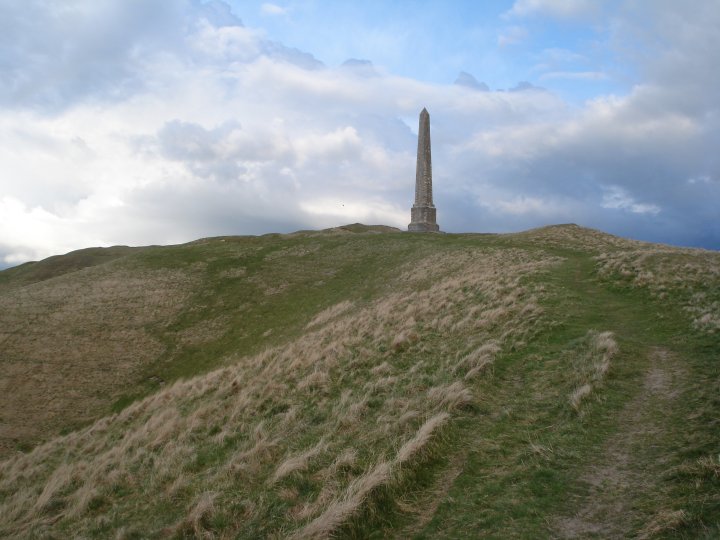
View of the Oldbury Long Barrow and the Obelisk

View of the Oldbury Long Barrow and the Obelisk

View of the Oldbury Long Barrow and the Obelisk from the A4

d – Oldbury Long Barrow
e – Obelisk
f – Round Barrow
i – Earthwork
k – Earthwork
l – Circular cavity
m, m2 – Dwelling Pits

View of the Obelisk showing the extensive disturbances made by the chalk diggings

View of Oldbury hillfort and the White horse from the A4


View of Oldbury hillfort and the Obelisk from the A4

View looking through what may have been the original entrance towards the Obelisk


View from the back of Oldbury hillfort looking towards North Down showing the defences

View from the back of Oldbury hillfort looking towards Morgan’s Hill
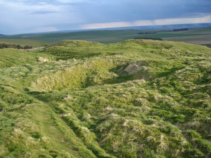
View from the back of Oldbury hillfort showing the extensive disturbances made by the chalk diggings. The left side of this photo includes the round barrow shown in Cunningtons 1864 map of the site.
Thu 29 July 11.00-15.30
Start point TBC; directions will be sent on booking
Join a Neolithic expert and archaeologist on this walk of around 8 miles through the Stonehenge landscape. Booking essential.
National Trust – 01980 664780
[email protected]
www.nationaltrust.org.uk/stonehengelandscape
Sat 24 – Sun 25 July 10.00 – 17.00
Old Sarum, Salisbury
This is your chance to meet a real archaeologist and to uncover artefacts from Old Sarum’s history.
English Heritage – 01722 335398
[email protected]
www.english-heritage.org.uk/oldsarum
Fri 30 – Sat 31 July 11.00-15.00
Venue – check website for full details.
Excavation open day. Come along to find out more about reality of life in Exmoor’s Iron Age some 2500 years ago.
Exmoor National Park Authority – 01398 322289
[email protected]
www.exmoor-nationalpark.gov.uk
Event is part of the Festival of British Archaeology – 17th July to 1st August 2010
Fri 23July 11.00 – 15.00
Meet at Goat Hill Bridge pull in (see website for details)
Guided walk uncovering 5000 years of history in one of Exmoor’s most evocative landscapes, the Royal Forest and the Chains.
Exmoor National Park Authority – 01398 322289
[email protected]
www.exmoor-nationalpark.gov.uk
Event is part of the Festival of British Archaeology – 17th July to 1st August 2010
Tue 20 July 11.00-15.00
Meet at Dunster Steep car park
Discover the remarkable Iron Age fortifications around Dunster with a National Park archaeologist.
also – Make a Roman Mosaic
Sat 24 July 11.00 – 15.00
Dunster Steep, Dunster, Minehead
Learn about Roman mosaics and make your own small Roman style mosaic to keep.
Exmoor National Park Authority
01398 322289
[email protected]
www.exmoor-nationalpark.gov.uk
Events are part of the Festival of British Archaeology – 17th July to 1st August 2010
Sat 17 July 10.00-16.00
The Moorland Hall, Wheddon Cross
A series of illustrated lectures by experts about the regional context of Exmoor at this time.
Exmoor National Park Authority – 01398 322289
[email protected]
www.exmoor-nationalpark.gov.uk
Event is part of the Festival of British Archaeology – 17th July to 1st August 2010
Sat 17 July 10.00 – 16.00
Upper Row Farm, Laverton, Near Bath
Join us for a day of activities for all the family. Join the Roman children’s army have a go at excavation and see a roundhouse.
Bath and Camerton Archaeological Society (BACAS)
07977 176402
[email protected]
www.bacas.org.uk
Event is part of the Festival of British Archaeology – 17th July to 1st August 2010
Sun 18 July 11.00 – 16.00
Little Stoke Park, Stoke Gifford
A great day of archaeology including prehistoric metalworking displays, flint knapping, finds identification, historic cooking,
geophysics demonstrations and other activities for children.
South Gloucestershire Council, Southern Brooks Archaeology, Museums Group & South Gloucestershire Heritage Forum
[email protected]
www.southglos.gov.uk/historicenvironment/archaeology
Event is part of the Festival of British Archaeology – 17th July to 1st August 2010