
The Bell barrows within the wood are safe from the plough but not tree roots and wildlife.
Image credit: Chance - Aug 2007

The Bell barrows within the wood are safe from the plough but not tree roots and wildlife.

One of the Bowl barrows within the wood showing the damaged caused by animals and vegetation.

The Bowl barrow nearest the wood and on the corner of the track as it skirts the wood.

The most western Bowl barrow has been reduced to virtually nothing but is still just visible.

Looking along the barrows outside the wood from the top of the Bowl barrow in the corner.

Of the barrows in the Lake group, those that stand outside the wood are best preserved such as this Bell barrow and the smaller Bowl barrow.
Lake Barrow Group
Field notes – Visited 5th Aug 2007
There are three different and separate barrow groups south of Normanton Down, all of which are within the Wilsford cum Lake parish. Apart from the Lake group, there is the Lake Down barrow group (SU 117 393) which is actually on Lake Down, east of Druids Lodge and above Spring Bottom. The other group is known as the Wilsford Barrow group (SU 118 398) and this sits on the spur between Wilsford Down and Lake Down, on the western slope of Spring Bottom.
The Lake group are located just off the track that runs past Normanton Down and onto the A360 at Druids Lodge. These barrows are on private land but in order to get permission to view them you need to walk past them to Westfield farm.
This group contains at least fifteen bowl-barrows, four bell-barrows, two disc barrows and a long barrow. The farm track separates the main barrows of the group, the northern set containing the long barrow and disc barrows sit in a wood, while on the southern side of the track are two bell and three bowl barrows, one of which has been greatly reduced. To the north-west lay a satellite group of four bowl barrows which were completely excavated by Professor William Grimes in 1959 due to the damage they were under from being ploughed down.
Although Colt Hoare and William Cunnington carried out a lot of the excavations in the area, many of the barrows in this group including both the disc barrows, were opened by a former proprietor, Rev. Edward Duke, unfortunately with little, if any record. The Neolithic long barrow however, aligned north-west to south-east, 42 metres long, 23 metres wide and 2.5 metres high, appears never to have been opened or excavated in any way. The bell and bowl barrows which stand in the triangular open area between the two arms of the wood are the best preserved although the one furthest west is greatly reduced. These were the subject of Duke’s excavations in 1807, but there is doubt as to what he found in which barrow.
The barrows within the wood were difficult to photograph when I visited at the height of summer due to the extensive vegetation. There was a stench of death and I think a badger set had been the scene of slaughter. Some of the barrows had certainly been damaged by burrowing, if not by the tree roots that had engulfed them. I couldn’t get too far into the overgrowth to see the disc barrows or the so-called, Prophet Barrow which was said to be the place a French prophet preached from in 1710.
An interesting barrow group if you have the time to walk down from Stonehenge and get permission to look around them but I would recommend you did this in the winter months when the trees are bare and you can get a clearer view of the barrows.

Drinking cup from Hoare’s barrow No.93 which lies just north of the Cursus on Stonehenge Down

The Stonehenge urn


The camp at Amesbury called Vespasian’s Camp
The camp near Amesbury, between Stonehenge and the town, upon elevated ground, was, according to Stukeley, commonly called Vespasian’s, and he endorses the name. It is locally known as “the ramparts”. Sir R. Hoare considers that this was originally the stronghold of those numerous Britons who inhabited the plains around Stonehenge, an asylum in times of danger, for their wives, children, and cattle; and that like other camps of the same kind, it was occupied, as occasion or necessity required, by Romans, Saxons, and Danes.
“It occupies the apex of a hill, surrounded on two sides, east and south, by the river Avon, and comprehends within its area 39 acres. It extends in length from south to north, and terminates in a narrow rounded angle at the latter point. It was surrounded by a single vallum, which has been much mutilated on the east side in forming the pleasure grounds of Amesbury Park. The ramparts on the western side towards Stonehenge, are very bold and perfect. It appears to have had two entrances, north and south ; the former still remains perfect and undoubted. The area is planted and fancifully disposed in avenues, walks, &c., near the principal one of which, and on the highest ground, is the appearance of a barrow, but much disfigured in its form.’’ The camp is divided by the high road which passes Stonehenge. In Stukeley’s Common-Place Book, is the following mention of it: ‘’The walls, Vespasian’s camp, as believ’d. The people of Amesbury say the area of it is 40 acres, single trench, one graff towards Stonehenge.” In his ” Stonehenge described,” he describes the camp as “an oblong square, nicely placed upon a flexure of the river, which closes one side and one end of it. There is an old barrow inclos’d in it, which doubtless was one of those belonging to this plain, and to the temple of Stonehenge, before this camp was made”
Stonehenge and its Barrows by William Long, Esq., M.A., F.S.A. 1876
Dr. Thurnam’s account of his opening the Long Barrow in 1863
About a mile-and-a-half to the west of Stonehenge, on the boundary of the parishes of Winterbourne Stoke and Wilsford, is a cluster of circular barrows, which, as in many other instances, are grouped around an immensely long tumulus. The twenty six tumuli, which, in addition to the long barrow, form this group, are mostly of the more elegant, and probably less ancient, forms.
In five, the interment has not been found ; two, however, are those absurdly called ’ pond barrows,’ and probably not sepulchral. Of the twenty one, seven have been raised over the entire body, and fourteen over the burnt remains. All are probably of the ’ bronze period; ’ and in three, containing skeletons, and one, burnt bones, there were fine blades or pins of that metal, one of the last with an ivory handle. Drinking cups, or other earthen vases, were obtained from four of the barrows; and there was a bone pin with another of the deposits after cremation.The tumulus is about 240 feet in length, and nine in height at the north east end, where it has a breadth of about 65 feet; at the other extremity it is not quite so high or broad. The summit is thrown up almost to an acute ridge, but at the two ends the surface is more rounded. On each side is a trench stretching the whole length of the barrow, but, as usual, not continued round either end.
A large excavation at the south-west extremity, disclosed no sepulchral traces; and this immense mound, with an interment only at one end, was no doubt intended as much for a monument as a tomb. At the north-eastern end., about two feet below the highest part of the tumulus were six skeletons, viz ; one of a man of about sixty years, one of a young woman under twenty, one of a child about seven, and three of infants of less than two years, the youngest, perhaps, featal. The skull of the man lay to the north-east, that of the woman to the south-west. Secondary interments of the Anglo-Saxon period have been found near the summit of long barrows ; but these were obviously British, as shown by the flexed position of the skeletons, by an empty vase of very coarse British pottery, and an oval flint knife. The male skull is well preserved, and of extremely brachycephalic type ; the skulls of the woman and children were obtained in a fragmentary condition, but the latter present the same well-marked type, with the occiput flattened. These interments can hardly have been other than secondary, and of a later date than that for which the tumulus was erected ; and it became a question whether, on the primary interments being reached, the skull would prove of the same, or of dolichocephalic type.Continuing the excavation, the chalk rubble was dug through, to a depth of six feet, into a stratum of black unctuous earth, of which the lower third of the barrow through its entire length seems to have been formed. At a further depth of three feet, the chalk rock was reached, where were the remains of the original interment ; viz., the skeleton of a man laid on the right side, with the knees drawn up in a closely contracted posture, and the head to the south-west. Close to the right arm, lay a natural bludgeon-shaped flint, about 8 inches long, well adapted for being grasped in the hand; from one end of which numerous flakes had been knocked off. The skull was dolichocephalic ; though less decidedly so than many of the crania from the chambered barrows.
Near the back of the head was a round ‘cist’ or hole, scooped out of the chalk rock, about 18 inches wide and the same in depth. Two feet further to the north, were two similar cists of oval form, but somewhat larger, and scarcely so deep. These holes, like others beneath the long barrows of South Wilts, had perhaps been used for deposits of meat and drink, as a viaticum for the dead ; or possibly for the blood of human victims, whose mangled remains appear often to have been buried with the body of their chief in this class of tumuli. A few scattered bones of sheep and other animals were found near the summit, and about a yard from the feet of the primary interment, was the symphysis of the ischium of an old horse. The skeleton was that of man of less than middle stature ; viz., about 5 feet 6 inches.
Dr. Thurnam’s paper on ” Principal Forms of Ancient British and Gaulish Skulls,” printed in vol. i. of Memoirs of the Anthropological Society of London, 1865.

The Winterbourne Stoke group in 1810 showing how the group radiate out along the same axis as the original long barrow.
This group consist of the long barrow, two disc barrows, large bell barrows, and the smaller, but more numerous bowl barrows. The earthwork on the bottom left ran all the way down to the Lake group of barrows and their single, immense long barrow.
To date the road system has only been changed by a roundabout, a lay-by and the name A303.

The Normanton Down barrow group in 1810 showing how the group stretch out along the ridge over looking Stonehenge.
The group contains: two small long barrows 151 and 175, eight disc barrows, including the one William Stukeley dug 159 and Bush Barrow 158.

The Lake barrow group in 1810 showing the long barrow, two disc barrows, large bell barrows, and the smaller, but more numerous bowl barrows. The earthwork on the left ran all the way up to the Winterbourne Stoke group of barrows, while the one of the right was designed to encompass a specific area only.
Account of Bush Barrow made by Leslie V. Grinsell in which he reflects upon other known burials from the same period and attempts to draw together relevant sources. See below for an index of all referances included.
Apparently a large bowl-barrow, probably the most notable round barrow in Wessex for its grave-group.L. V. Grinsell, Stonehenge Barrow Groups (1979), page 30
In the early 18th century it was planted with thorn trees (Stukeley 1740, 46 and TABS XXXII, XXXIII).
The first investigation was on 11 July 1808, when Cunnington explored it but failed to locate the interment. Reluctant to be defeated by a barrow, he had another try in September that year.
The tree roots had not penetrated deep enough to interfere with the primary deposit as the mound (which is c. 120 feet in diameter) was then c. 11 feet high. ‘Contrary to the more general practice we found on the floor of this Barrow the skeleton of a stout and tall man, lying from south to north’. (Most of the other skeletons he had excavated had their head to the N). The extreme length of the thighbone was 20.5 inches, indicating a man around 6 feet tall.
About 18 inches south of the head (which shows that the head was at the south) was a large quantity of bronze rivets intermixed with wood and some thin bits of bronze, these objects covering a space of 12 inches or more. Cunnington and Hoare interpreted this assemblage as the remains of a shield, but Coles (1962, 172) has stated that ‘there seems no possible way in which these objects could be arranged to form a shield. The flat-headed rivets are so short and relatively thick, that they could not have been driven through any wood without splitting it’. This, together with the position of the remains above the head, and their diameter which is small for a shield but about right for a headpiece flattened by pressure from the soil above, makes it most probable that they are the surviving pieces of a helmet, ‘perhaps utilising wooden plates as scales’. A possible parallel, from a Minoan chamber tomb at Ayios loannis near Knossos, also above the head of a fragmentary skeleton, is dated to c. 1450 B.C. (Hood 1956).
The interment has been reconstructed by Ashbee (I960, 77) on the assumption that it was in the extended posture. Cunnington’s account provides no evidence of this; but parallels of Early Bronze Age chieftains’ interments in Germany and Brittany suggest that this could well be the case. (S. Piggott 1965, 127, Fig. 67).
The disposition of the rest of the grave furnishings was:
Near the shoulders, a flanged axe of copper or bronze with impression of cloth on blade, and traces of wooden knee-shaft handle (Thomas 1966). Near the right arm, a large six-riveted copper dagger of Gerloffs Armorico-British A type with traces of wood on blade, and handle of wood inlaid with a zig-zag pattern formed by an immense number of minute gold pins in poinlille style, for which there are parallels in Armorica. Near this dagger was a small lozenge-shaped plate of sheet gold with incised ornament, which Cunnington thought may have belonged to the sheath of the dagger. Near the right arm was also a large bronze grooved dagger of Gerloff’s Armorico-British B type. Beneath the fingers of the right hand was a ‘lance head of brass, but so much corroded that it broke to pieces in taking out’.
On the breast was a large lozenge-shaped plate of sheet gold bearing incised ornament; it was originally ‘fixed to a thin piece of wood over the edges of which the Gold was wrapped’, and it is holed at the top and bottom corners for fastening to the dress as a breast plate. On the right side of the skeleton was a polished and perforated mace-head of fossil Stromaloporoid believed to
be from the area of Teignmouth in South Devon; around its hole are traces of a bronze ring with which it was attached to its shaft by a bronze pin. Near this mace-head were 3 cylindrical bone mounts of zig-zag form and two end-pieces of the same material, believed to be the fittings for either the shaft of the mace-head or some other baton of authority.
They resemble those from shaft grave Iota in Grave Circle B at Mycenae, in the National Archaeological Museum at Athens (8623-4) but not illustrated by Mylonas (1973); they accompanied a male adult skeleton with a bronze sword and are dated c. 1600/1550 B.C. Similar examples in gold were found in a dolmen at Kerlagat in the Morbihan (Le Rouzic 1931; Taylor 1978). These in turn might have been inspired from the Eastern Mediterranean. The gold belt hook was near the right arm. If the Aegean parallels are meaningful the date of the Bush Barrow burial could approximate to that of shaft grave Iota (c. 1600/1550 BC) rather than that of the bronze rivets which are too generalised for close dating in them-selves.A letter from Hoare to Cunnington, dated June 1810, states that ‘Bush Barrow should be completed and filled up’; it was evidently not properly filled in until at least a year and nine months after it was dug.
No. 158.
Though Dr. Stukeley has given an engraving of this tumulus, under the title of BUSH BARROW, it does not appear that he ever attempted to open it. It was formerly fenced round and planted with trees, and its exterior at present bears a very rough appearance from being covered with furze and heath. The first attempts made by Mr. Cunnington on this barrow proved unsuccessful, as also those of some farmers, who tried their skill in digging into it. Our researches were renewed in September, 1808, and we were amply repaid for our perseverance and former disappointment. On reaching the floor of the barrow, we discovered the skeleton of a stout and tall man lying from south to north: the extreme length of his thigh bone was 20 inches. About 18 inches south of the head, we found several brass rivets intermixed with wood, and some thin bits of brass nearly decomposed. These articles covered a space of 19, inches or more ; it is probable, therefore, that they were the mouldered remains of a shield. Near the shoulders lay the fine celt* TUMULI PLATE XXVI No. 1, the lower end of which owes its great preservation to having been originally inserted within a handle of wood. Near the right arm was a large dagger of brass, and a spear-head of the same metal, full thirteen inches long, and the largest we have ever found, though not so neat in its pattern as some others of an inferior size which have been engraved in our work. These were accompanied by a curious article of gold, which I conceive had originally decorated the case of the dagger, TUMULI PLATE XXVII, NO.I . The handle of wood belonging to this instrument, No. 2, exceeds any thing we have yet seen, both in design and execution, and could not be surpassed (if indeed equalled) by the most able workman of modern times. By the annexed engraving, you will immediately recognize the British zigzag, or the modern Vandyke pattern, which was formed with a labour and exactness almost unaccountable, by thousands of gold rivets, smaller than the smallest pin. The head of the handle, though exhibiting no variety of pattern, was also formed by the same kind of studding. So very minute, indeed, were these pins, that our labourers had thrown out thousands of them with their shovel, and scattered them in every direction, before, by the necessary aid of a magnifying glass, we could discover what they were; but fortunately enough remained attached to the wood to enable us to develop the pattern. Beneath the fingers of the right hand lay a lancehead of brass, but so much corroded that it broke to pieces on moving. Immediately over the breast of the skeleton was a large plate of gold, TUMULI PLATE XXVI, in the form of a lozenge, and measuring 7 inches by 6. It was fixed to a thin piece of wood, over the edges of which the gold was lapped: it is perforated at top and bottom, for the purpose, probably, of fastening it to the dress as a breast-plate. The even surface of this noble ornament is relieved by indented lines, checques, and zigzags, following the shape of the outline, and forming lozenge within lozenge, diminishing gradually towards the centre. We next discovered, on the right side of the skeleton, a very curious perforated stone, some wrought articles of bone, many small rings of the same material, and another article of gold PLATE XXVII, No. 3,4, 5 . The stone is made out of a fossil mass of tubularia, and polished ; rather of an egg form, or as a farmer who was present, observed, resembling the top of a large gimlet. It had a wooden handle, which was fixed into the perforation in the centre, and encircled by a neat ornament of brass, part of which still adheres to the stone. As this stone bears no marks of wear or attrition, I can hardly consider it to have been used as a domestic implement, and from the circumstance of its being composed of a mass of seaworms, or little serpents, I think we may not be too fanciful in considering it an article of consequence. We know, by history, that much importance was attached by the ancients to the serpent, and I have before had occasion to mention the veneration with which the glain nadroeth was esteemed by the Britons ; and my classical readers will recollect the fanciful story related by Pliny on this subject, who says, that the Druid’s egg was formed by the scum of a vast multitude of serpents twisted and conjured up together. This stone, therefore, which contains a mass of serpularia, or little serpents, might have been held in great veneration by the Britons, and considered of sufficient importance to merit a place amongst the many rich and valuable relicks deposited in this tumulus with the body of the deceased.

Looking over the disc barrow dug by William Stukeley towards Bush Barrow
Account of William Stukeley’s diggings on a disc barrow in the Normanton Down group:
We dug up one of those I call Druid’s barrows, a small tump inclos’d in a large circular ditch. I chose that next to bushbarrow, westward of it. Stonehenge bears hence north-east. We made a cross section ten foot each way, three foot broad over its center, upon the cardinal points. At length we found a squarish hole cut into the solid chalk, in the center of the tumulus. It was three foot and a half, i.e. two cubits long, and near two foot broad, i.e. one cubit: pointing to Stonehenge directly. It was a cubit and half deep from the surface. This was the domus exilis Plutonia cover’d with artificial earth, not above a foot thick from the surface. In this little grave we found all the burnt bones of a man, but no signs of an urn. The bank of the circular ditch is on the outside, and is 12 cubits broad. The ditch is 6 cubits broad (the Druid’s staff) the area is 70 cubits in diameter. The whole 100.


View of Stonehenge down looking east from the Cursus Barrow group towards the end of the Cursus.

View of Stonehenge Down looking west from the Cursus Barrow group towards the gap in the Fargo Plantation made by the Cursus.

View of Stonehenge and car park from Amesbury G43


Bell-barrow,(Amesbury G43) recorded as No. 28 by Sir Richard Colt-Hoare and opened by Lord Pembroke in the year 1722 with no record of contents. Dimensions in 1957: mound dia. 99 ft; mound height 10 ft; berm width 25 ft; ditch width 18 ft; ditch depth 3 ft.

Bell-barrow,(Amesbury G43) recorded as No. 28 by Sir Richard Colt-Hoare and opened by Lord Pembroke in the year 1722 with no record of contents. Dimensions in 1957: mound dia. 99 ft; mound height 10 ft; berm width 25 ft; ditch width 18 ft; ditch depth 3 ft.

Looking along the Cursus Barrow group eastwards

Bell-barrow (Amesbury G43) and Twin bell-barrow (Amesbury G44).
Bell-barrow was opened by Lord Pembroke in the year 1722 with no record of contents
The Twin bell-barrow was open by Stukeley who found
In W mound: high in the mound a skeleton, head to N. This was opened again in 1803 by William Cunnington who found, south of centre, a large oblong chalk-cut pit in which was a cremation with 6 horn beads.
In E mound: Stukeley found a cremation (primary or secondary ?) in an urn, with a bronze knife-dagger, bronze awl, gold-mounted amber disc, and faience beads, amber studs, amber beads and space-plates, and beads of shale and ‘yellow glass’. He writes ‘This person was a heroin, for we found the head of her javelin in brass’.

Plate 30 – Prospect of the West end of the Cursus of Stonehenge
From Stonehenge, A Temple Restor’d to the British Druids, by William Stukeley, 1740
The Cursus and it’s group of barrows looking east. A is the end of the Cursus and the Long Barrow; B is the gap on King’s Barrows Ridge and the course of the Aveune; C is Stonehenge with the modern route of the A303.

The Cursus group in 1810 from the map of the area made by Hoare. The numbers start at 28 and progress westwards to 44. The largest barrow, Amesbury G55 was marked as No.40 by Hoare as ‘in point of size, the monarch of the plain‘
The following account of the Cursus group of barrows comes from William Stukeley in 1740 and moves westwards.
On the 1810 map by Hoare, the numbers would equate to 28 onwards.
This account contains all we know of the contains from some of these barrows.
In 1722, my late Lord Pembroke, Earl Thomas, who was pleas’d to favour my inquiries at this place, open’d a barrow, in order to find the position of the body observ’d in these early days. He pitch’d upon one of those south of Stonehenge, close upon the road thither from Wilton: and on the east side of the road. ‘Tis one of the double barrows, or where two are inclos’d in one ditch: one of those, which I suppose the later kind, and of a fine turn’d bell-fashion. It may be seen in Plate IX. On the west side, he made a section from the top to the bottom, an intire segment, from center to circumference. The manner of composition of the barrow was good earth, quite thro’, except a coat of chalk of about two foot thickness, covering it quite over, under the turf. Hence it appears, that the method of making these barrows was to dig up the turf for a great space round, till the barrow was brought to its intended bulk. Then with the chalk, dug out of the environing ditch, they powder’d it all over. So that for a considerable time, these barrows must have look’d white: even for some number of years. And the notion of sanctity annex’d to them, forbid people trampling on them, till perfectly settled and turf’d over. Hence the neatness of their form to this day. At the top or center of this barrow, not above three foot under the surface, my Lord found the skeleton of the interr’d; perfect, of a reasonable size, the head lying toward Stonehenge, or northward.Stukeley then goes on to descried the rest of the barrow group looking west. The largest barrow, Amesbury G55 was marked as No.40 by Hoare as ‘in point of size, the monarch of the plain’.The year following, in order to prosecute this inquiry, by my Lord’s order, I begun upon a barrow north of Stonehenge, in that group south of the cursus. ‘Tis one of the double barrows there: and the more easterly, and lower of the two: likewise somewhat less. It was reasonable to believe, this was the sepulture of a man and his wise: and that the lesser was the female: and so it prov’d, at least a daughter. We made a large cut on the top from east to west. After the turf taken off, we came to the layer of chalk, as before, then fine garden mould. About three foot below the surface, a layer of flints, humouring the convexity of the barrow. These flints are gather’d from the surface of the downs in some places, especially where it has been plow’d. This being about a foot thick, rested on a layer of soft mould another foot: in which was inclos’d an urn full of bones. This urn was of unbak’d clay, of a dark reddish colour: crumbled into pieces. It had been rudely wrought with small mouldings round the verge, and other circular channels on the outside, with several indentures between, made with a pointed tool, as depicted in Plate XXXII. where I have drawn all the sorts of things found in this barrow.
The bones had been burnt, and crouded all together in a little heap, not so much as a hat crown would contain. The collar bone, and one side of the under-jaw are grav’d in their true magnitude. It appears to have been a girl of about 14 years old, by their bulk and the great quantity of female ornaments mix’d with the bones, all which we gather’d. Beads of all sorts, and in great number, of glass of divers colours, most yellow, one black. Many single, many in long pieces notch’d between, so as to resemble a string of beads, and these were generally of a blue colour. There were many of amber, of all shapes and sizes, flat squares, long squares, round, oblong, little and great. Likewise many of earth, of different shapes, magnitude and colour, some little and white, many large and flattish like a button, others like a pully. But all had holes to run a string thro’, either thro’ their diameter, or sides. Many of the button sort seem to have been cover’d with metal, there being a rim work’d in them, wherein to turn the edge of the covering. One of these was cover’d with a thin film of pure gold. These were the young lady’s ornaments. And had all undergone the fire: so that what would easily consume fell to pieces as soon as handled. Much of the amber burnt half thro’. This person was a heroin, for we found the head of her javelin in brass. At bottom are two holes for the pins that fastned it to the staff. Besides, there was a sharp bodkin, round at one end, square at the other, where it went into a handle. I still preserve whatever is permanent of these trinkets. But we recompos’d the ashes of the illustrious defunct, and cover’d them with earth. Leaving visible marks at top, of the barrow having been open’d, to dissuade any other from again disturbing them: and this was our practice in all the rest.
Then we op’d the next barrow to it, inclos’d in the same ditch, which we suppos’d the husband or father of this lady. At fourteen inches deep, the mould being mix’d with chalk, we came to the intire skeleton of a man. The skull and all the bones exceedingly rotten and perish’d, thro’ length of time. Tho’ this was a barrow of the latest sort, as we conjecture. The body lay north and south, the head to the north, as that Lord Pembroke open’d.
Next, I went westward, to a group of barrows whence Stonehenge bears east north-east. Here is a large barrow ditch’d about, but of an ancient make. On that side next Stonehenge are ten lesser, small, and as it were crouded together. South of the great one is another barrow, larger than those of the group, but not equalling the first. It would seem, that a man and his wife were bury’d in the two larger, and that the rest were of their children or dependants. One of the small ones, 20 cubits in diameter, I cut thro’, with a pit nine foot in diameter, to the surface of the natural chalk, in the center of the barrow; where was a little hole cut. A child’s body (as it seems) had been burnt here, and cover’d up in that hole: but thro’ the length of time consum’d. From three foot deep, we found much wood ashes soft and black as ink, same little bits of an urn, and black and red earth very rotten. Some small lumps of earth red as vermilion: some flints burnt thro’. Toward the bottom a great quantity of ashes and burnt bones. From this place I could count 128 barrows in sight.Stonehenge, A Temple Restor’d to the British Druids, by William Stukeley, 1740
The following account of Stonehenge and it’s many Barrows comes from 1740:
I COME in the last place to speak of the barrows, observable in great numbers, round Stonehenge. We may very readily count fifty at a time, in sight, from the place; easily distinguishable: but especially in the evening, when the sloping rays of the sun shine on the ground beyond them. These barrows are the artificial ornaments of this vast and open plain. And it is no small entertainment for a curious person, to remark their beauties, their variety in form and magnitude, their situation. They are generally of a very elegant campaniform shape, and done with great nicety. There is likewise a great variety in their shape, and turn, and in their diameters, in their manner of composition. In general, they are always upon elevated ground, and in sight of the temple of Stonehenge. For they all regard it. This shews, they are but superficial inspectors of things, that fancy from hence, great battels on the plain; and that these are the tumultuary burials of the slain. Quite otherwise; they are assuredly, the single sepulchres of kings, and great personages, buried during a considerable space of time, and that in peace. There are many groups of them together, and as family burial places; the variety in them, seems to indicate some note of difference in the persons there interr’d, well known in those ages. Probably the priests and laity were someway distinguish’d; as well as different orders and stations in them. Most of the barrows have little ditches around, extremely well defin’d. In many is a circular ditch 60 cubits in diameter, with a very small tumulus in the center. 60 or even too cubits is a very common diameter in the large barrows. Often, they are set in rows, and equidistant, so as to produce a regular and pretty appearance, and with some particular regard to the parts of the temple, the avenues, or the cursus.From: Stonehenge, A Temple Restor’d to the British Druids, by William Stukeley
The following account of the ridge eastwards of Stonehenge by William Stukeley, giving the term Old and New, to the Barrow groups.
At the bottom of the valley, and the end of the strait part of Stonehenge avenue, 100 cubits from Stonehenge, as we said, the eastern wing of the avenue turns off to the right, with a circular sweep, and then in a strait line proceeds eastward up the hill.Stonehenge, A Temple Restor’d to the British Druids, by William Stukeley, 1740It goes just between those two most conspicuous groups of barrows, crowning the ridg of that hill eastward of Stonehenge; between it and Vespasian’s camp, separated from them both by a deep valley on each side. These two groups of barrows are called generally the seven king’s graves, each. I call that most northerly, the old seven kings graves, for there are really 7, tho’ but 6 most apparent; they are all set at greater distance, all broader, flatter, and as it is most reasonable to suppose, older than the other.
The other are set closer together, of a more elegantly turn’d figure, campaniform, and in all appearance, much later than the former. Therefore I call these, being southward and directly between Stonehenge and the town of Ambresbury, the new seven kings barrows. Of the seven old, the most northerly one and probably the oldest, is exceeding flat and as it were, almost sunk into the earth with age; so that it is scarce visible at a distance. The avenue runs up to the top of the hill, just between them: and they make as it were wings to it, and I believe were design’d as such, when set there.
Although enclosing 25 ha, this oval-shaped hillfort has little natural strength.
Its ramparts still stands 2-4 m high, though its ditch has long since been silted up.
There are a number of gaps in the earthworks – the one on the east is usually considered to be ancient.
William Stukeley and Richard Colt Hoare referred to internal enclosures and these were noted on the aerial photographs taken by 0. G. S. Crawford and A. Keiller which are included in their 1928 book, Wessex from the Air.
This would point to the camp being used as an agricultural enclosure or tribal meeting place, rather than a defensive work.

The Cursus Group as seen from King Barrow Ridge

The first of the Old King Barrows is much reduced as it once housed a fuel tank when Seven Barrows Cottages stood here in the 1950’s

View of the central Old King Barrow
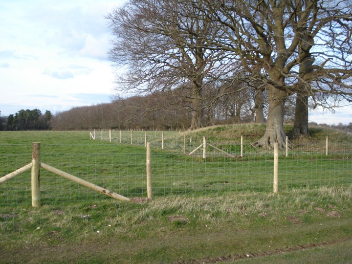
View of one of the Old King Barrows looking towards the site of the Cursus Longbarrow

New gate and fence enclosure for one of the Old King Barrows

New gate and fence enclosure for the central Old King Barrow. Another Barrow can be seen through the trees

View looking at the course of the Avenue, the hollow, over King Barrows Ridge

The route of the Avenue over King Barrows Ridge between the Old and New King Barrow groups
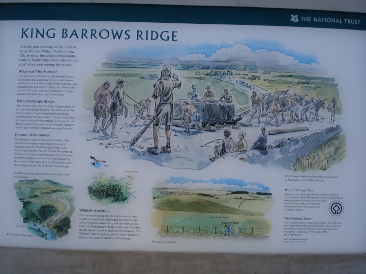
Artist impression of King Barrows Ridge showing the movement of the Stonehenge’s Sarsens

View of Kings Barrow Ridge from the last barrow looking south

Kings Barrow Ridge showing barrows and beech trees planted in 1722 by Lord Pembroke

View looking along part of Kings Barrow Ridge

Cutting back hazel and forming new wildlife habitat on Kings Barrow Ridge

Modern grave where ashes were scattered on Kings Barrow Ridge