Summarises features of this defencive monument including incomplete status when abandoned in prehistoric times.
C Michael Hogan
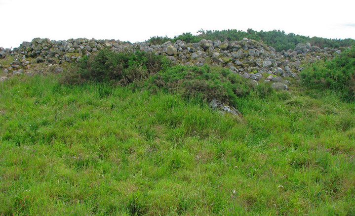
Intermediate range view of Catto from the northeast, illustrating the central range of the barrow.
Image credit: [email protected] Hogan

Closeup of one of the large cists within the Catto Cairn. The depth from the cairn top to the pit bottom is approximately 1.5 metres. The camera position is approximately three metres above the pit bottom.
Image credit: [email protected] Hogan
Catto Long Barrow is an extensive prehistoric stone structure with remnants of seven stone tombs. The site has yielded archaeological recovery of stone axes and its vicinity is replete with tumuli, hoards of worked flint and ancient battleground remains. Situated on locally high open ground, the site offers expansive views in all directions. The site has been suggested in the literature as a likely location of a major battle with invading Danes.
GEOMETRY. I measured the length of this ancient monument at 49 metres, one metre longer than published on the Aberdeen Council website. (Aberdeenshire, 2006) The stones are of considerable size ranging to characteristic length of greater than two metres, but more commonly having typical dimensions closer to 40 centimetres. There are seven sizable pit depressions within the stonework, others having suggested the pits are results of modern disturbance; however, based upon the considerable build-up of mosses on the surface of pit rocks, if the pits are of modern formation, I would judge the disturbance to be at least a century into the past. Ferguson (1875) witnessed the opening of some of the series of cists or stone tombs within the Catto Cairn. Subsequently archaeological publications (Society, 1904) noted that the Catto monument would have been of much greater original height, and states clearly that the pits are remnants of cist structures. The earliest literature reference I found of Catto Cairn is in Sinclair’s 1795 account indicating an elliptically shaped monument of circumference 120 metres. (Sinclair, 1795)
Aside from the pits noted above and the necessarily uneven texture necessitated by the stone sizes themselves, the top of the cairn is a remarkably large expanse of relatively level surface, contrasted with the more conical or mounded shapes of many other large cairns of this region. The orientation of the cairn axis is approximately west northwest to east southeast, very similar to the Longman Hill orientation (Hogan, 2008) somewhat farther to the northwest from Catto.
AREA ARCHAEOLOGY. There are numerous archaeological sites in the local area of the southern extremity of the historic parish of Longside, especially on the eastern side of Laeca Burn. Among the notable local sites are Silver Cairn and .Dun-na-chaich, a large oblong mound. Somewhat to the west are the Skelmuir Hill standing stones. The vicinity has been documented as historically rich in surface finds including sizeable nodules rich in flint tools.
Immediately to the east of Catto there were hundreds of mounds which survived to the mid 1800s; the diameters of these structures varied from about three to six and one half metres. Furthermore, there were over 17 of these to the southwest that were exceptionally well defined circular features.with very flat tops; each of these finely crafted mounds were approximately 2.5 metres in diameter.
BATTLEFIELD. This region is portrayed by several early writers as a site of significant battles with invading Danes. (Smith, 1875) Sinclair (1875) also notes that the immediate local area of Catto is rich with archaeological features including many tumuli with square inner chambers. !8th century legends link the Catto site with history of the Moray Firth and with some type of ancient foreign invasion. The military connection is underscored by the fact that the plain to the immediate west is called “Battle-fauld"on older maps..
J.B. Pratt is the first author I found who suggested Catto Cairn as a battlefield, noting that the cairn itself, by its high ground position, was a likely point for the point d’appui, where troops would have marshalled. To the west the steeply ravined Laeca Burn forms a natural impediment to attack, whereas an historic morass lies to the north. In the 19th century there were many more tumuli, Pictish house sites, graves and circular stone campfire sites throughout the vicinity of Catto; however, aggressive local farming has destroyed most of these features in the last two centuries.
NATURAL FEATURES. The surrounding grain fields suggest that this locale would have been an agriculturally attractive area to Neolithic farmers. In addition to the nearby Leuca Burn, there is recorded 18th century evidence of prolific springs (historically termed “Kemp-Wells” or “Morris Wells”), whose prominence has subsequently been masked by agricultural drains installed as early as the late 18th century; however, as late as the last quarter of the 19th century, the Morris Wells supply potable water to Peterhead. The name “Leuca” undoubtably derives from the granite boulder exceeding 60 tons, which lies in the Leuca Burn streambed west of Catto .Based upon the large tree trunks found in the Leuca ravine, it is likely that most of the early Holocene landscape (even indeed the Medieval landscape!) would have featured a majority of the land forested with large deciduous trees along with Scots Pine. Presently dense gorse patches envelope much of Catto’s perimeter, a common circumstance since gorse is a plant that thrives on stony soils, typical at the verge of ruined ancient stone monuments in Scotland.
North of Catto lay another dense historic forest, but due to deforestation by aggressive farming practises, by the 19th century the land was transformed to a barren wasteland known as the Moss of Savoch of Longside; this outcome provides an example of the failed attempt to cultivate an area not best suited for crops. This northern area yielded large numbers of spearheads and arrow points as reminders of the earlier great battle fought here.
To the southwest is the drainage of Leuca Burn with the Hill of Aldie beyond, where further prehistoric native forestation would have been found, now replaced by a monoculture coniferous plantation, virtually devoid of native understory or wildlife.
REFERENCES
* Aberdeenshire Council (2006) “Catto Long Barrow”
* William Ferguson (1881) ‘’The Great North of Scotland Railway: A Guide’’, Published by D. Douglas, 1881, 174 pages
* Society of Antiquaries of Scotland (1904) ‘’Proceedings of the Society of Antiquaries of Scotland’’, pp 256-262, published by Neill and Company, Edinburgh, Scotland
* C. Michael Hogan (2007) ‘’Longman Hill fieldnotes’’, The Modern Antiquarian
* Alexander Smith (1875) ‘’A new history of Aberdeenshire’’, published by Lewis Smith
* Sir John Sinclair and William Creech (1795) ‘’The Statistical Account of Scotland: Drawn Up from the Communications of the Ministers of the Different Parishes. By
Published by William Creech
* William Ferguson (1881) ‘’The Great North of Scotland Railway: A Guide’’, Published by D. Douglas, 1881, 174 pages
* Society of Antiquaries of Scotland (1904) ‘’Proceedings of the Society of Antiquaries of Scotland’’, pp 256-262, published by Neill and Company, Edinburgh, Scotland

Standing atop the Catto long barrow with its gorse fringe and cows grazing in the background.
Image credit: C.Michael Hogan

This view is from atop the cairn itself looking across one of the more pronounced stone pits. The lichens and mosses covering the stones form a colourful mosaic. The view is looking toward the west.
Image credit: C.Michael Hogan

Large outlying stone near Catto Cairn with the monument itself in the background, looking west southwest.
Image credit: [email protected] Hogan

This is the middle of the three wedge tombs of the Cashel Town Wedge Tomb group. The view is from close range looking northwest.
Image credit: C.Michael Hogan

Looking southeast at the tail of Longman Barrow. The Photographer is standing in the saddle or gap of the barrow, slightly toward the west end of that saddle.
Image credit: C.Michael Hogan

Looking south over the southeast rim of Cairn Catto.
Image credit: C.Michael Hogan

Looking southwest at Cairn Catto across a grain field.
Image credit: C.Michael Hogan
Longman Hill is a Bronze Age long barrow situated atop a prominent rounded landform near the north coast of Aberdeenshire. An almost 360 degree panorama is available from the barrow top, including views over the North Sea. A salient feature at this archaeological site is a massive pit on the northwest flank of the barrow, which was used in modern times as an excavation for road base material; however, the pit may have been the source of some of the rock and earth used in the barrow construction. Judging from the massive barrow size as well as the existence of extensive subsurface shaly sides of this pit, it is likely that the barrow has a somewhat higher percentage of stone in its interior than suggested by the Aberdeenshire Council website.
ASPECT. Based upon the commanding view afforded by the Longman Hill, this location would have been attractive to early man of this region not only for ceremonial purposes, but also for the strategic reason of being able to see hostile forces by land and sea for considerable distances. Views to the south extend to the Bennachie Range and even the Grampians on the distant horizon. To the northwest is the coastal plain along the North Sea including Banff Bay. To the west are views of the Moray Firth and Foudland Hills. Other distant features easily seen are Ben Rinnes, Bin Hill near Cullen and the Buck of Cabrach. The best lookout post is afforded by the northwestern apex, which is termed a circular mound by the Aberdeenshire Council. In reality, this feature is rather ovoid in shape, but clearly commands the most extensive views, largely because its height of approximately 4.4 metres exceeds the lesser height of the eastern end of the barrow. The only defect in an otherwise full panoramic view is a small topographic rise to the northeast, which occludes a small slice of the otherwise full 360 degrees. Pictish peoples clearly favoured such sites having an expansive coastal view for ceremonial and intensive use, with Kempstone Hill providing a parallel siting opportunity further south in Aberdeenshire. (Hogan, 2007)
BARROW GEOMETRY. The barrow length approximates 66 metres by my measurement, one metre less than the Aberdeenshire Council estimate, (Aberdeenshire, 2006) but about ten percent higher than the value set by Callander. (Callander, 1924) The barrow axis is approximately northwest to southeast, with the higher elevation end being at the northwest. Callander’s original photograph illustrates a western cairn face which is more clearly circular with evidence of more regular stonework than is now extant, suggesting that raiding of some of the surface stones likely occurred when the modern quarry was used to extract road construction material. The quarry pit is approximately six metres in depth.
At the monument’s northern end, there is a nearly circular cairn or mound I measured to be 21 metres in diameter and 4.3 metres in height (consistent with the 1924 report of Callendar). My measurement of the total monument length is 67 metres, also consistent with Callendar’s original recording and the more recent Aberdeenshire Council website. I also measured the elevation of the lower eastern end of the barrow, which earlier authors had not reported; that elevation is approximately 2.5 metres above grade level.
ARCHAEOLOGICAL RECOVERY. On September 18, 1886 a finely made urn 30 centimetres in height was recovered from the barrow’s west end. (Transactions, 1897) This vessel contained calcined bones and is deemed a secondary burial. Seventeen months later a second urn was found approximately 20 centimetres in height; this specimen was decorated with a zigzag ornamentation but contained no obvious human remains, although the discoverers opined it had a funerary purpose, possibly due to the black mould-like residues on the interior. The second urn was found with its mouth within a second saucer-like ceramic. Both urns had been exposed by recent rain erosion and were not found at the base of the cairn. A nearby ancient monument is Cairn Lee, situated approximately 1.5 kilometres to the northeast.
ECOLOGY AND HYDROLOGY. Soils on the flanks of Longman Hill are very fertile and produce robust crops of barley and other grains in current times. With the mild climate afforded by proximity of the North Sea combined with such soil richness, this locale would have presented the Neolithic farmer with an productive environment. While there is a paucity of larger rocks in the general area, the barrow itself has some sizeable rocks, especially at the base of the western edge, re-enforcing my earlier suggestion that this specific area may be a locally rich rock source. The Burn of Myrehouse, which drains to Banff Bay, is an important source of surface water, lying approximately one kilometre west of Longman Hill barrow. Furthermore the headwaters of one branch of the Burn of Melrose are situated as a spring about 1.2 kilometres to the northeast. Surface water would have likely been abundant to early man here, as suggested by the presence of the Bogs of Melrose approximately 1.3 kilometres to the northwest, in addition to the flow of the Burn of Myrehouse. It is also likely that the Burn of Myrehouse formed a more extensive prehistoric bog before the advent of field drains that generally appeared in this region in the Late Middle Ages; in fact the word root “myres” is associated with boggy areas within Scotland. Finally, the immediate local area abounds with place names such as “Boghead”, “Bloodymire” and “Burnside”, all suggesting an early local abundance of water.
REFERENCES
* Aberdeenshire Council (2006) “Longman Hill”
* C. Michael Hogan (2007) ‘’Kempstone Hill fieldnotes’’, The Modern Antiquarian
* J.Graham Callander (Dec. 24, 1924) ‘’Long cairns and other prehistoric monuments in Aberdeenshire and Banffshire and a short cist at Bruceton, Alyth, Perthshire’’, Proceedings of the Society
* Transactions of the Banffshire Field Club (1897-8) p. 38

Longman Barrow viewed from the south flank of Longman Hill to illustrate the entire length of the barrow. Note the prominent notch separating the west from east end, and also note that the west end is of a higher maximum elevation.
Image credit: C.Michael Hogan

Longman Barrow viewed from the north side, illustrating that the west end of the barrow (image right) is higher than the east end or “tail”. This image is a two stitch panorama.
Image credit: C.Michael Hogan

Darney Ringfort viewed from the south-southwest, overgrown from this side by tall grasses and wildflowers.
Image credit: C.Michael Hogan

Large stone I found by probing at the ground surface near the northwest of the Longman Barrow virtually buried in the tall grass. Such a large stone measuring approximately 80 cm in length is quite unusual to be found on the ground surface in this region; therefore, it is likely that this stone may have formed part of the barrow monument, possibly even as a kerbstone. This stone was lying approximately three metres away from the base of the long barrow.
Image credit: C.Michael Hogan

Looking northwest along the southern edge of Longman barrow. The view is of the northern section of the barrow including the northern apex, whilst the photographer is standing within the gap betwixt the northern and southern elements of the barrow. Note the gorse and tall grass atop the barrow. The horizon is the north coast area near MacDuff at Banff Bay.
Image credit: C.Michael Hogan

Quarry pit encroaching on northern side of Longman Barrow. Although much of the quarrying has been conducted in modern times to mine roadbed material, it is possible that the pit was begun in prehistoric times to produce some of the material for the barrow.
Image credit: C.Michael Hogan

Site of the Balbridie Neolithic timber house along the south Deeside road.
Image credit: C. Michael Hogan


Castell Bach Cwmtydu, situated atop a level coastal cliff promontory along the Irish Sea.
Image credit: C. Michael Hogan

Looking west from a point atop the east end of Leighterton Long Barrow. This overgrown monument has a recognisable curvature, particularly at the east end.
Image credit: C. Michael Hogan

Southern portion of the spurryhillock site in the foreground, where trenching and pit excavation has yielded Neolithic decorated pottery and lithics that are likely Mesolithic. This site is at the western edge of the town of Stonehaven.
Image credit: C. Michael Hogan
Professional journal article by Derek Alexander published in the Proc. Soc. Antiq. Scotland, regarding the finds at Spurryhillock. Some of the lithics recovered suggest the site was a factory for mesolithic blade manufacturing. Charcoal recovered has included some specimens traced to oak (quercus).


The northeastern top portion of Bucharn Cairn illustrating the relatively level oval platform nature of the top. Note expansive views to the northeast in the background, which feature Blackhall Forest and the furthest horizon of mountains north of the River Dee.
Image credit: C. Michael Hogan


Looking at the massive broadside of the Hilton of cairngrassie standing stone. Photograph is taken looking west-northwest.
Image credit: C. Michael Hogan

The northern end of Cantlayhills Cairn, which portion of the monument stands approximately 2.4 metres above the field grade level. Welsh ponies shown are roughly equal in distance from the photographer as the cairn, providing the reader with a reasonable guage of the monument scale.
Image credit: C. Michael Hogan

Close up of the Hilton of Cairngrassie standing stone looking south-southwest within the farm field that the stone is situated. The aspect illustrates the thin side of this massive monument.
Image credit: C. Michael Hogan

Looking at the southeast portion of the Longman Hill Long Barrow from atop the highest point of the barrow along its northwest segment. The distant horizon represents the hills around New Byth, approximately 12 kilometres to the southeast.
Image credit: C. Michael Hogan

Pendinas Lochtyn viewed from the western approach on the coastal trail.
Image credit: C. Michael Hogan


The Bruxie Hill monument viewed from the west, illustrating the relatively level platform style top in this profile view.
Image credit: C. Michael Hogan

The view is through a partially open canopy of mixed coniferous and broadleaf secondary forest.
Image credit: C. Michael Hogan

The Cairnshee Woods Cairn as viewed from the south within a clearing on the wooded hill.
Image credit: Cairnshee Woods @ C.Michael Hogan

Photo and some geometric parameters for the Catto monument.
Listing and description of the Aillemore court tomb, including geometrics of the monument. There is also a description of the geographical setting of Aillemore sited on a ridge above the Bunsheenshough River valley.
Color photo of the Cregduff Henge from a low altitude aerial view. Depicted are the concentric geometry, entrance, kerbstones and some internal stones.
This site hosted by Google Books sets forth numerous megalithic monument descriptions including a writeup on page 377 regarding Cerrig y Gof. Rodney Castleden describes the uniqueness of the radial tomb design for this region of the Irish Sea area.
At least 27 tombs were recently discovered at Tarquinia, approximately 50 miles north of Rome. Some of these tombs date to at least as early as 700 BC. These pre-Roman recoveries also include frescoes and animal burials.... Read the full story in the Scotsman News.
Photographs, site plan and geometrics displayed of this triple walled, concentric cliff-top stone fort.
A flint blade dating circa 4000 years Before Present was found during roadworks in Herefordshire. This discovery is very near to the Rotherwas Ribbon, an ancient trackway constructed in the Bronze Age from fire fractured rock. The find amplifies the importance of the Rotherwas Ribbon site, which is presently being buried under a new road by the Herefordshire Council....Read the full story by BBC News
The Journal of the Royal Society of Antiquaries of Ireland presents a 1902 snapshot of the Iskancullin megaliths (p285-6 in this Google Books website)

Standing stone of Hilton of Cairngrassie viewed from the Causey Mounth. The standing stone is on the horizon, with grazing cows in the foreground and an ancient drystone wall in the midground.
Image credit: C.Michael Hogan
Historic photograph of 1902 Cappaghkennedy Wedge Tomb. (Be sure to double click on the image for enlarged photo and also to reveal details of the historic photo.)
Photograph of Ballymihil Wedge Tomb.
Archaeologist David Mason has developed a new theory of the basis for siting Agamemnon’s tomb, based on topographical features and road layouts in the vicinity of the tholos tombs at Mycenae. Read the full article in Current Archaeology.co.uk
Geometric descriptions and photographs of the Bohonagh Stone Circle. A brief discussion of cupmarks at this site is set forth.
1-50 of 105 postsNext page