
A mid-holiday walk to the Ring. Never fails to impress.
Image credit: A R Cane
A mid-holiday walk to the Ring. Never fails to impress.

We only had a road map to aid our navigation to this site . Having parked up in Boroughbridge it took ages to find someone who new what The Devil’s Arrows were and also how to get to it. Surprising how clue-less some people are about what’s under their noses! Glad we did find it though – what amazing stones these are!

All three menhirs. The southern-most stone nestles within it’s leafy surroundings on the left.

Middle and northern-most stones, one of which is pretending to be the trunk of an oak tree.

The most southerly menhir in the group. You can just about see the other two across the hedge and the shortest one appears to be in the middle, which it isn’t, so they’re not in perfect alignment sadly....there again, so what? it was some feat just standing up these monsters!
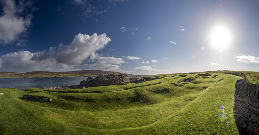
Panorama of the broch and it’s outer banks and ditches. The Island of Rousay crouches in the background trying to lure us, but we were strong (and running out of time and money).

The broch in it’s wonderful entirety with the shadow of a man scratching his head in confusion.

Panorama of the interior with the entrance to what may, or may not, be a souterrain in the foreground.


Are you thinking what I’m thinking? An Iron Age stone sofa!
And so endeth the Orkney Saga.....or does it?

Orkney’s Imperial Guard doing what they do best....guarding.

The beautiful backdrop of The Bay of Skaill, which was probably also responsible for covering the settlement in sand thousands of years ago.

What’s for dinner mum? Not voles again?!

Another view of the same dwelling.

I wonder if Tolkien ever visited here?


Sort of ancient and modern at the same time.

Panorama of the big hoose with Loch of Harray behind.

A bit chilly though in the Winter I’d imagine.

Handy for fishing.

The Comet Stone with Salt Knowe and The Ring of Brodgar beyond.

This illustration from 1820 was in Skail House near Skara Brae and though it’s titled ‘Stones of Stennis, Orkney’, it’s clearly Brodgar. Possibly there was no distinction between the two sites or maybe the title is just very literal.

The first visit in splendid sunshine. The lack of other visitors is down to extreme Photoshop.

Just visible is a chestnut paling fence sectioning off part of the circle where ‘work’ was being carried out, though just what that was I’m not sure.


Panorama taken from the top of Salt Knowe with the Loch of Harray in the background

As much of the whole tomb as I could fit in looking vaguely North.


One of the inner chambers complete with Neolithic carpeting.

The tomb’s shadow cast over the cliff edge.

The narrow passage and late afternoon sun. I’m guessing the Winter Solstice rising sun might shine right down there? Anyone know?

Cup marked inner curb stone of the South West cairn.

Interior of the South West cairn with nice tree alignment.


Beautifully shaped stones around the North East cairn.

Torch lit loveliness at the North Eastern cairn. Not sure if that’s the Northern lights or just greenish clouds? Whatever, it added to the atmosphere.


The road bisecting the stone circle surrounding the South West cairn.

Do you think they were losing their enthusiasm by the time they got round to building this one?


