A small bowl barrow and a larger saucer barrow at the side of a field. Easy access from the bridleway down the edge of the field for a quick look. Hooray for the landowner here who has left the scheduled monuments alone. Having said that they have suffered in the past, but you can still make out the dimensions of it all. The arrangement is unusual in that the bowl barrow was raised second and overlapped the edge of the saucer barrow.
UncleRob

The round barrow next door again. There was no sign of humans using the plot as anything but a short cut from one road to another, but once I stopped and took a photo, this local inhabitant came out of the undergrowth to say hello.
Image credit: Copyright waived UncleRob

Round the back of the long barrow is its neighbour, a similarly flattened round barrow. Both this “West” long barrow and the “North” one were given accompanying round barrows later on.
Image credit: Copyright waived UncleRob

As seen from the Stoke Charity Road.
Image credit: Copyright waived UncleRob
This is one of those unusual mounds that are not scheduled ancient monuments, yet have been treated kindly by the modern landowners. OS says Tumulus in that alluring typeface but then they have been known to get it wrong. There is not much to see but a bump of about 50cm height in some rough pasture. It is all quite horsey round here so hopefully will not deteriorate further for future generations. I wonder whether it was ever very big or one of the smaller late bronze age efforts.

Seen from the West end of the barrow
Image credit: Copyright waived UncleRob

Seen from the East end of the barrow
Image credit: Copyright waived UncleRob

Finding this barrow makes up (almost) for the depressing state of most of the other sites in the area. It lay unknown in woodland for a very long time, unploughed and unexcavated, before being found by surveyors involved in the expansion of the nearby A34 dual carrageway in 1979. Given its proximity to the other long barrows around South Wonston, I think it should be regarded as part of that group.
The long barrow suffers from the usual rabbit burrows and tree roots, and at some point people have dug little chalk pits (?) near the edge of the mound but thankfully not into it. The ditches are on two sides and do not seem to meet up round the west end of the mound. Access is relatively simple from nearby rights of way but remember it is in private woodland.
It is 60m long, 20m wide and 2-2.5m high. Berms of 2m wide and ditches of 0.1m deep and 5m wide. (All figures from the official scheduling on MAGIC).
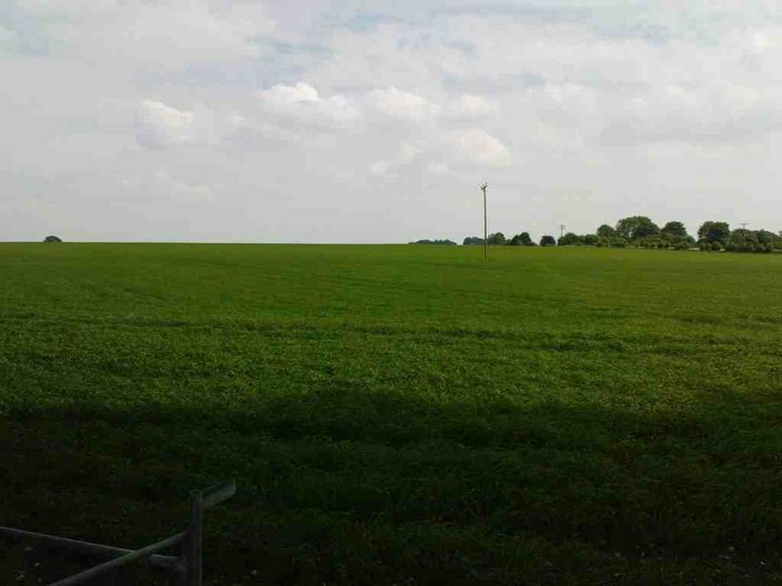
This photo is looking up from the gate on the bridleway at SU467368. The site of the barrows is on the skyline at centre. Yup, there’s not much to see.
Image credit: Copyright waived UncleRob
This poor old thing has been obliterated by ploughing. To find the site I had to refer a lot to the Royal Commission on Historic Monuments’ excellent “Long Barrows in Hampshire and the Isle of Wight” (1979, ISBN 0117008370). They make it pretty clear that this long barrow, and its neighbouring round barrow, have been ploughed out of existence, and deliberate efforts were made at some point to flatten it and disperse the chalk across the field. Aerial photos to this day show the ditches but there is nothing to see on the ground. It is on top of a ridge and I started walking round the outside of the field to get up to it but was put off by nearby shotguns. I can’t recommend anyone bothers to visit it but I felt it ought to be recorded here as part of the South Wonston group and testament to how much ancient heritage is already lost.

This is well preserved and is now at the bottom of two gardens. You can see it from the Alresford Drove byway on the north-east edge of South Wonston. The householders keep the grass trim and stop any naughty rabbit burrows, so this is perhaps the best of the local long barrows. Long grass, weeds, junk etc seem to have been tidied up a lot since the 1976 photo in the Royal Commission on Historical Monuments book (Long Barrows in Hampshire and the IOW).
Dropped by last weekend in the sunshine with a couple of friends. I hadn’t been here for 15+ years and had forgotten just how big the disc barrow is. A nice peaceful spot though it is surrounded by housing. You can see the disc barrow clearly on take-off from Southampton airport, but that also means when you’re on the ground the peace is disturbed by a procession of noisy Fokkers overhead.
There are two bowl barrows between the road and the disc, one quite obvious and the other only a little mound about 0.3m high. The smaller one is the only that hasn’t been excavated in the past. Don’t be confused by the information board which gets bowl and disc mixed up!
Sarsen stones are comparatively rare in this district and I think this is the biggest, though who knows what is waiting for future generations waterlogged underneath St Mary’s Church in Twyford...

From the centre of the disc barrow, looking back towards the large bowl barrow. In the foreground is the small mound at the centre of the disc barrow. Much harder to see (I took lots of photos from every angle...) is a smaller secondary mound further away and to the right. That makes it north-west of the centre.
Image credit: UncleRob copyright waived

Just one part of the ditch around this whopper of a disc barrow.
Image credit: UncleRob copyright waived

Another clear pair of groovy grooves. Possibly others on either side too.
Image credit: UncleRob copyright waived

In at least three places on different sides of the sarsen there are these parallel grooves. Uncle’s hand (5’11”, pianist) is here to give you a sense of size. Glacial striations? Too regular I think, especially as they are on opposite sides of the stone. Perhaps they were made in ploughing up the stone, but again I’m not sure it would have been ploughed “over easy”. Any thoughts y’all?
Image credit: UncleRob copyright waived

To give you an idea of the size of the sarsen, and how lovely the place is in early summer sun, ahhh.
Image credit: UncleRob copyright waived
A pair of quite large barrows at the top of Compton Down, nicely preserved despite being in a thoroughly ploughed field that has covered up any ditch that they may have been. The GPO stuck a telephone pole in the middle of one too. I like telephone poles but there is a limit.
There is one barrow considerably larger than the other and they overlap a bit. They have been excavated in the past but no mention of any findings on the official record. MAGIC notes worked flints visible on the surface. Many barrows around these parts are conspicuously off to one side of a hilltop so they can be seen from down below (or indeed so they can see down there!) but these are right on top and invisible until you get fairly close.
Close-up access requires going across the field which is of course supposed to be rather naughty, though all the dog walkers of Oliver’s Battery seem to do it. I used to live very nearby and even my neighbours whose houses backed onto the field didn’t know what these mounds were! Approach on foot by Texas Drive or from the end of Old Kennels Lane; both involve reasonably flat and easy dirt tracks.

Seen from the East side, from near the smallholding called Texas.
Image credit: UncleRob

Mmmm, nice telephone pole. This is the larger of the two. Don’t be put off by the vegetation, you can still see a lot of the shape of the barrows, and there are some tasty blackberries in there.
Image credit: UncleRob

Seen from the Northeast side. Yew Hill in the background.
Image credit: UncleRob
The higher land to the south-west of here is the point where the main watersheds of England meet, which is to say that water poured on the ground will flow equally into the Irish Sea, English Channel and North Sea. Could this have been known in antiquity? I don’t see why not as knowing the geography of Great Britain, albeit handed down orally, would be pretty important. It makes Swallowhead springs all the more significant as one of the first points where water appears flowing off from the “roof of England”. (I borrow the phrase from Ken Clifford, who stirred four of us up into taking a holiday there in 2000 to find the “roof” – there isn’t an exact spot – but it is a great excuse to spend some time larking about in this wonderful part of the country).


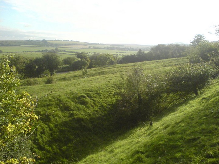
Having seen this marked on the OS map but read Dickie’s fieldnotes, I didn’t hold out much hope for it. But when I stumbled through into the copse it was a real jaw-dropping moment. It was late autumn and a bright day with sun coming through the golden leaves and there in front of me was a beauty of a long barrow, the entire width of the copse. MAGIC says 72 metres long, 22m wide at east end and 17m wide at west end, and 2m high. OK, it’s no West Kennet, there are trees growing out of it and rabbits living in it, but that’s not bad for 5000 or so years old. I think I must have a soft spot for antiquities overgrown by woodland, there is some extra tranquillity and mystery about it. Anyway, my top tip is to sneak up from the road further east from Dickie’s approach. There is a gate leading into woodland and from that you can turn right into a field. Look back down toward the road; if you are in the right field there should be a old fallen tree trunk down at the bottom. Walk away from the road and go straight ahead into the copse. No sign of who owns the land but it is easy to visit without damaging any crops, fences etc.
Also, the pin on the Google map is in the wrong copse... it’s the next one to the north.
Well worth a visit if you are in the Winchester area, these are off the Alresford road in a nature reserve for butterflies opposite St Swithun’s School and next door to the masons’ lodge. You can easily walk there from town (well, you do have to puff up a hill of course). Wonderful view across the hills and over the Chilcomb valley. Believe it or not these were the first barrows I ever encountered, so they are in part to blame for my interest! I still like coming up here early in the morning to reset the brain. It’s not exactly a secluded spot but it’s very peaceful. MAGIC gives lots of details, including archaeological finds. There are five barrows here though you are likely only to count the easternmost three as the others are a shadow of their former selves. There is also a further barrow at the east end of the down.

The largest of the well-preserved barrows. To give you a sense of scale, you can see Uncle’s bicycle on the right.
Image credit: UncleRob

Looking west across the alignment of barrows / brow of the hill. There are two barrows very much flattened over time among the vegetation.
Image credit: UncleRob

The middle of the five, looking south west. St Catherine’s Hill is in the left background, seen from an unusual angle, and yes there’s that sodding motorway again.
Image credit: UncleRob

The three most prominent barrows, looking east.
Image credit: UncleRob
Just to the east of St. Catherine’s Hill (SU 492277 and surroundings) are what remains of the Dongas, the ancient trackways leading down off the South Downs into the valley of the River Itchen and either to ford the river at what became Winchester or to the main entrance to the hillfort on St Catherine’s Hill. I’ve posted a few photos of that area on this site, though they could deserve one of their own. Thankfully a strip of nature reserve is preserving this landscape, though the western end of them was chopped off in the infamous Twyford Down motorway cutting. Easily found (he says – I only recently discovered the main part of them after walking past them oblivious for many years). At the top of Plague Pits Valley, cross the footbridge over the motorway, pausing to make out the faded 1990s Donga Tribe graffiti. The noise pollution here is terrible! You can also come up a path from Garnier Road opposite the St. Catherine’s park & ride car park, which is more direct but less interesting. On the other side of the M3 chasm, go through a gate on your right and then look out for gaps in the bushes to your left, before you reach the top of the slope and another gate. The dongas are waiting for you through there! You get a real sense of the land opening up into a dry plateau, real Thomas Hardy stuff, with a big sky where you can get caught by rain clouds sweeping in off the Channel. Whenever walking about here with my mother, she often commiserates with the ancient folk who did their daily grind up here “without any Long Johns”!

Among the Dongas near the Eastern end of the nature reserve is this little mound, seemingly worn into an elongated shape by two of the tracks. It does stand out among the other shapes here, but whether it is a worn-down barrow I can’t say. It’s about 1 meter high and might once have been 15 meters diameter. There’s no obvious sign of a ditch. However, it certainly looks from the dimple on top like some Victorian gent thought the same as me at some point and took a shovel to it.
Image credit: UncleRob

Looking down one of the deeper dongas toward the Itchen valley and Winchester.
Image credit: UncleRob
There are several dongas alongside one another at this point, which would have been the only way to descend to the north of St Catherine’s without going down a steep embankment – important if you’re taking animals to market. Going the other way, where the land flattens out on top of the downs they seem to diverge, with some heading east towards Cheesefoot Head and others south-east towards Morestead.
Image credit: UncleRob

Looking down from two converging dongas at the side of St Catherine’s Hill, this is the view you would have had as you reached the end of your journey over the top of the downs... except for the blue A33 sign in the distance...
Image credit: UncleRob
Visited the site in May 07 and found it quite easily between the flat sandy beach and a rocky outcrop behind the stones. There is a little cave at the foot of the hill, off to one side, and when both stones were standing they would have been side by side when facing inland. They could have appeared as a gateway to the hill, or to the sea.

Both stones seen together on a typically unpredictable wet and windy day in May.
Image credit: UncleRob

From the bottom of the hill, by the river Itchen, showing just how steep it gets and how it would make you think twice about charging up there with your mates for a spot of pillaging. The daisies are growing on the former site of the M3. The current motorway is not so picturesque!
Image credit: UncleRob

A little way East down the nearby road, in the direction of Studland, this layby / view point seemed to have two stones originally from the circle or its now dispersed avenue. Similar sandstone (Nine Barrows Down is chalk / flint downland) and size.
Image credit: UncleRob

One of the uprights nearest the road, about 4 foot high.
Image credit: Little Dragon

One of the group of uprights nearest the road, about 4 foot high.
Image credit: Little Dragon

Everything people say about this being a magical place is quite true. You can’t help but be quiet and respectful as the stones appear one by one, forming a broken and scattered circle. ShropshireTraveller has posted a map at the Megalithic Portal website (see link off main Rempstone page) that is pretty accurate from my visit to this site in September ‘07. I would just place the layby a bit further west. I recommend anyone planning a visit to print that map off first. The shrubs and nettles have grown a lot by the verge of the road since the 2004 photos you see here, and you won’t be able to see the stones from the road, but you can still get in easily enough. Just before the autumn equinox , the sun set into the base of the ridge of Nine Barrows Down as it stretches away to the west.
Previous page201-247 of 247 posts