

Lambay Island from the beach in Skerries. The cairn is clearly visible in the centre of the island.

In the grounds of a church and graveyard with its own daffodil decorations!

This is the National Monuments Database entry:
Description: Comprises a round -topped mound beside a stream in a low-lying location on the grounds of Cadbury’s factory. The top has been planted with trees (diam. 19.20m, H 4.80m). (Morris 1939, 189; Dillon Cosgrave 1977, 110).
Compiled by: Geraldine Stout
Date of upload: 26 August 2011
Date of last visit: 06 February 1997
Now here’s a thing: I couldn’t get access to this as it’s on the grounds of a chocolate factory! I was told by the security guard that I might get permission and be given a guided tour if I came back the following day, Monday.
Here’s another thing: There is no mention of this in Tom Fourwind’s book on prehistoric Dublin and I had never heard of it until reading Joseph E. Doyle’s Ten Dozen Waters: The Rivers and Streams of County Dublin. Indeed, there it sits not 20 metres from the Santry river, just before it flows under the Malahide road. Doyle calls it a tumulus. It is mentioned on the Wikipedia page for the Santry river and it is on the archaeology.ie National Monuments database, number DU015-074-, added by Geraldine Stout no less.
So why isn’t it more widely known? It’s right there, less than a stone’s (cough) throw from one of the busiest roads in the north suburbs.


A solitary slab about 150 metres south-east below the wedge tomb. Is this the only surviving stone of a second wedge tomb? The Arch. Survey of Co. Donegal says that: “The 2nd and 3rd editions of the OS maps show two stones here but there is no visible trace of the second stone.” So maybe... but if so, why would the destroyers leave just one (or two) stone(s) standing?
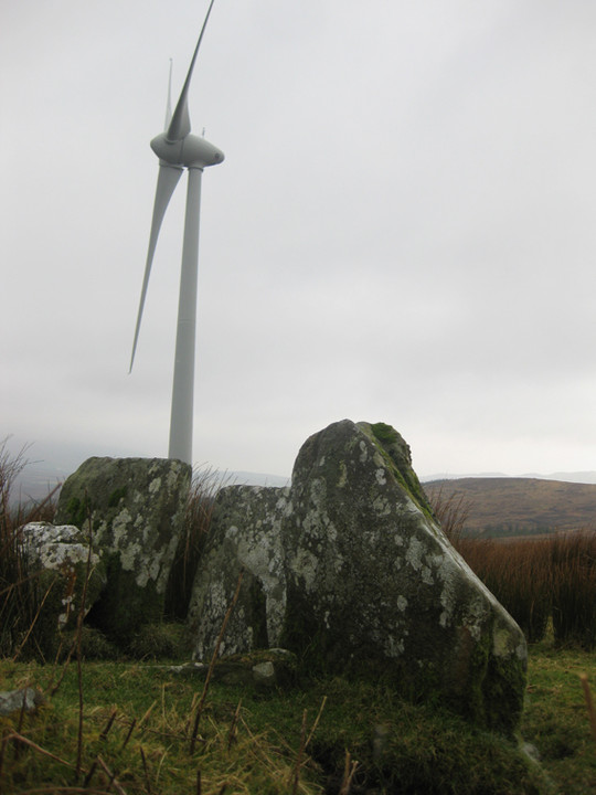
A bitterly cold, wind-lashed day on a boggy hill two miles due east of Buncrana. Twenty metres into the field is Meenkeeragh wedge tomb, almost hiding away in the rushes. It’s survived all this time reasonably well and even retains some of its dignity amongst the monstrous wind turbines that unrelentingly whirl and whoop as we ponder the past and the future.
There’s quite a bit left to see. The gallery seems to be split into two chambers but I’m not sure if the dividing stone is not a slipped roofstone. The whole uncovered tomb is filled with rubble which seems to have come from the structure itself. The three stones that make up the portico/facade are really rather beautiful, the middle one leaning out from the tomb gracefully. Double walling is visible on both sides but more obvious on the south. Much of the tomb is still buried in its covering cairn.
The huge windmills do detract from the atmosphere, though the freezing gale that nearly blew us to hell put paid to much of our musings – and made obvious why this place was picked to help fuel the never-ending thirst that we all have for energy.

Fort, and hilltop with cairn in the distance

Note the tumulus. It can be seen for real in Bogman’s picture

The slab/standing stone – possibly all that’s left of a second wedge tomb on this wind-blasted hillside

The metre square “standing stone”


Adam & Eve are smaller than I remembered them to be. Little Red Riding Hood is not yet 4-years-old.


Dark shot on a dull day, curve of ditch showing up containing a snowdrift.

A leftover from Halloween occupies the basin 2/2/13

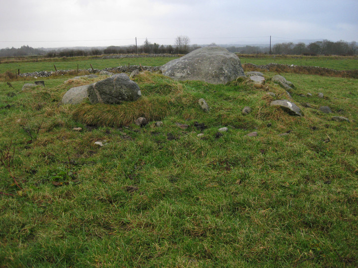
Re-visited this today and had a bit more of a nose around. I really doubt that this is, or was ever, a round barrow. It strikes me more as a ringfort or rath – it has that feel about it. However, there is a bank and ditch just a metre inside the tree/shrub-line so it could certainly be a flattened/robbed-out barrow.
It’s situated above the mill road on a natural, defensible hillock and is on the grounds of Stewart’s Hospital. There has been work carried out near it recently but it seems that due respect was given to the monument during construction.


From:
“The History and Antiquities of Tallaght In The County of Dublin” By William Domville Handcock, M.A.
Second Edition Revised and Enlarged. Dublin, 1899
The mountains and hills in the parish are :- Mountpelier; Slievenabawnoge, or the mountain of the lea; the hill of Ballymorefinn, or Finn’s great town; Slievebane, or the white mountain; the mountain of Glassavullaun, or the stream of the little summit; Kippure, or the trunk of the yew tree; the Black hill; Seeghane, or the seat; Carrig (i.e., the rock); and Bryan’s hill.
Amongst objects of archaeological interest dating from primeval times there are in the townland of Ballinascorney a rath called Raheendhu, or the black fort, and two stone circles enclosing the remains of a cromlech called the cairn of the second rock or the red hero?; in the townland of Ballymana a place of sepulture called Knockanvinidee, or the rennet hill?; in the town -land of Mountseskin a place of sepulture called Knockannavea, or the ravens’ hill, and a mound called the Bakinghouse hill; and in the townland of Glassamucky a place of sepulture called, Knockanteedan, or the little hill of the blasts or gusts; while in the townland of Castlekelly there are a number of sepulchral mounds including three known respectively as Meave’s hill, the hill of the rowan tree, and the red hill, as well as a cromlech and some stone circles; and on the hill called Seeghane, or the seat, there are a cairn and two cromlechs.
Amongst the wells in the parish are the following: – St. Paul’s well, in the town-land of Kiltalown; Moling’s well or the Piper’s well in- the townland of Corbally; the Fairy well, near Tymon Castle; the Lime Kiln well at Balrothery; the Chapel well, on the brink of the Dodder near Tallaght village; and St. Columkille’s well in the townland of Oldcourt.
(The parish he refers to at the beginning of the entry is Tallaght. This passage includes a mention of the rath, but it also contains mentions of other known, and less well-known sites. Hmmmm.)
I’ve been here many times and never once have I taken a satisfactory shot of the place. It’s on the left-hand-side of the track that you take to get to Ballymaice passage grave.
The forestry is planted very close to the edge of the ditch of the rath, but the west arc of the site is the most visible. This is yet another of those sites that I’d love to see cleaned up.

The curve of the pine plantation mirrors the curve of the bank and ditch on the west side of this site. It’s almost impossible to show this site in a photo, but on the ground its boundaries are very apparent.

Small winter pond in the ditch on the west side of this habitation site
US scientists say they can track early human movements by analysing molecules in ancient faecal matter.
Researchers were able to use prehistoric poo to establish the presence and size of a population dating back over 7,000 years.
They argue the method could be used to distinguish human from natural impacts on past environments.
Details have been published in the journal Proceedings of the National Academy of Sciences.
Ho hum, what have we here? I don’t rightly know but I loved the beach walk, the view across to Ireland’s Eye, and the freshwater (I think) lake on the landward side of the ‘mound’. Jealous of the owners of this place with their prehistoric mound and the beach over their back wall. Somewhere to visit on a sunny day after taking in the portal tomb in Howth.
200 metres down from Portmarnock train station is this suburban curiosity. What is it? Why was it put here? Will it last for much longer? The last can be answered with some confidence – at least into the near future with the over-the-top fencing that has been erected to, one presumes, protect it. The field it’s in is one of those places that looks like its ready to start the second the property collapse bottoms out. This one’s for the completists only.
Down an old muddy right of way is this 3 metre tall stone. For a couple of reasons this was my favourite site of the day. By the time I got to it, I was drenched and freezing, but forgot completely about that so taken in was I by the place.
I disturbed 3 donkeys, or Connemara ponies, on my way up to the place. I was the last thing they were expecting that day, given the dreadful weather, but on I marched regardless, though they stopped fretting when I gave them a wide berth.
And then to the stone, with its own fógra, perched on a small hillock or drumlin 3 metres above you as you first catch sight of it. The stone leans to the north, but is imposing, a crooked finger pointing accusingly at whatever.
There are many signs of habitation structures around this place, the most intriguing being the circular, beehive hut like building just 20 metres west of the stone. Other earthworks around the place confirm that this is an important site. If only the weather had been a bit better and I had had a bit more time...
Marked as a mound on the OS map, it’s hard to tell what this is. It struck me as either a. a ruined habitation site, maybe a hut site or something later, maybe iron age, or b. a ruined megalithic tomb. 400 metres south-west of here is an ogham stone, with the rath I placed on here 200 metres to the north.
200 hundred metres from Cartron mound, I couldn’t get close to this due to vicious barbed wire and livestock. It looks a superb example of its type but what is really intriguing are the large stones on its top. These resemble the wreck of a tomb from a distance and I left here mildly annoyed that I couldn’t investigate any closer.
When I first saw this stone from the road I thought: what a load of crap. It’s profile from above was square and it seemed to be little more than a scratching post. Down into the dip and closer it revealed itself to be quite a gem. From whichever way you look at it, you could be looking at a different stone each time. It’s about 2 metres high and wedge-shaped along its width. It reminded me of a piece of abstract art I may or may not have seen or imagined, maybe an early Picasso.
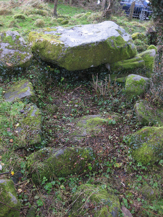
Ruined, roadside court tomb. I was surprised that nobody from TMA had been here before. There is still quite a bit of this tomb extant, with even a roofstone over the back end of the gallery. However, it’s in a cattle field and is unprotected. Some cairn material also remains and there are some stones of the court visible. That said, this is a wreck of a place, of interest only to those of us who’d travel a couple of hundred miles to say we’d been there.
Named as a wedge tomb on archaeology.ie, but not mentioned in the Survey of the Megalithic Tombs of Ireland. This is a sad wreck of a place, but maybe that’s because I visited on a wind and rainswept November day.
The round capstone sits above a tiny gallery/chamber, maybe a metre square. There is lots of cairn material about this chamber and the remains of a mound are clearly visible.
Roadside monument, south of Ballina, actually really just a cist, but you can see why it’s called a dolmen, here and elsewhere. The blocky capstone must weigh at least 30 tons and sits on top of two sidestones and a backstone, creating a small chamber.
It now resides in its own little enclosure beside a road that leads south-west from Ballina train station, surrounded on its east side by the ugly headquarters of the Road Safety Authority.


The roofstone is in place over the very small gallery/burial space. I reckon this is more likely a simple cist than a wedge tomb. It’s not mentioned in the Survey of the Megalithic Tombs of Ireland.

There is one roofstone in situ over the back of the gallery.

