
Hard to believe that they once planted a tree on the roofstone of the chamber, but there you go.
Image credit: ryaner
Hard to believe that they once planted a tree on the roofstone of the chamber, but there you go.
I really liked this little monument. Said to be part of “a complex of prehistoric sites”, there’s a ring cairn two fields away that 4 of the photos here are of, and there’s a quite substantial wedge tomb down the hill. This ‘cairn’ is very barrow-like and has a fosse, probably created by the digging of the material that makes up the mound. The stones on the mound may or may not be part of a disturbance/excavation.

Little-red-riding-hood for scale. She’s looking towards Lugnagun with its cairns and a passage grave.

More barrow-like than cairn-like – the whole field is dry but the fosse that surrounds this is still boggy. The diameter of the ‘cairn’ is about 10 metres and it stands proud of the ground to about .75 of a metre.
From the Celbridge Wikipedia page:
There is evidence of 5,000 years of habitation as evidenced by beads and quern stones in the National Museum from Griffinrath...

Didn’t get close to this as I had company with me. It looks quite substantial from the distance, maybe 3 metres tall.

Looking north over the two south-east mounds towards the main mound

The most westerly of the mounds to the left of the picture, looking east back towards the main mound


The brambles to the left of the shot probably cover the elusive fifth mound. The main mound is in the distance.

Looking south over one mound, towards the most southerly in the distance.

From on top of the main mound, looking over the passage/chamber area covered in last year’s brambles

This is the description of the main mound from the National Monuments database:
Situated on the coast at the mouth of the river Delvin. This passage tomb is part of Bremore cemetery (Rynne 1960, 79, Mound I). It comprises a circular cairn which is heavily grassed over (max. diam.29m; H 3.5m). Possible kerbstones on W side. Disturbance at NW may indicate the remains of a collapsed passage and chamber (Herity 1974, 209, 255).
So to Bremore passage grave cemetery once again. The endangered Bremore passage grave cemetery. Five recorded passage graves (by Herity), a recorded fulacht fia, a recorded unclassified barrow and an unrecorded shell midden, all within a small corner of a small headland in the northernmost part of the county Dublin coastline.
We parked on the lane and headed into the cropless field towards the south-eastern mound. If this ever was a passage grave, it’s been totally ruined beyond recognition. The mound, along with the next one a little to the north and the one to the extreme west of the group, are only recognisable as anything prehistoric because the farmer has desisted from ploughing them into oblivion. These three have a couple of boulders each that may be parts of kerbstones, but all three barely rise a half metre above the surrounding terrain. They are all elongated, their longer axis pointing back towards the main mound.
The main mound is a large, circular cairn that seems to have been robbed out, as opposed to the ‘collapse’ mentioned in the Monuments Database entry. It reminds me of the chunk taken out of Dowth. I had hoped to be able to explore the chamber/passage area a bit more given the time of year, but last year’s brambles are too tightly woven and still quite vicious. Pity.
The tomb is less than 5 metres from the shoreline. We traversed our way down below the main mound and found a rather impressive shell midden. This looks to have been a feasting area, but the sea has eroded into the material and is in danger of washing it away altogether.
The last of the five so-called tombs is barely recognisable under all the vegetation, even though growth has been slow with our late Spring this year.
The Irish translation given on the OS map sheet 43 for Bellewstown is Baile an Bheileogaigh. Beile or bile is the name given to old inauguration trees. So the town of the inauguration tree of the Ogaigh’s (possibly another version of Haughey?)
However, on the western approach to the town is a sign that says Sliabh B.(aile) na gCailleach, the Hill of the town of the Hag.
In the townland of Collierstown is this small barrow. It now lies trapped behind the ugly fencing of Bellewstown race-track.
This is the entry from the Arch. Inventory of Co. Meath:
Oval mound (dims. 17m N-S, 12m E-W, H 1.8m), disturbed by digging SSW-NW. Cist (ME027-029001-) found c. 2m W of mound.


The mound with the small grandstand of Bellewstown race-track in the background


The signpost as you enter Bellewstown from the west.
Edit: Sorry Ryaner, I’ve moved this one as despite the relevance in terms of the etymology of the placename, your folklore post says it all more eloquently.
TMA Ed.
Know locally as the Jack Stones, they are said to have been thrown to here from Tara by the legendary hero Finn MacCool.
(Throwing stones seems to have been a rather common habit of old Finn.)
On the way from Bellewstown to Herbertstown I nearly collided with these. They are not marked on the OS map sheet 43. Three large, squat megaliths sit there in the middle of a triangle that splits a y-shaped junction. They are said to be the remains of a stone circle on archaeology.ie but no other details are given. A nice curiosity, though I remembered seeing them on Megalithomania.com some years back.

The stones in their triangle at the junction of Greenanstown and Damselstown
From the Arch. Inventory of Co. Meath:
Natural rock outcrop to which earthen mantle has been added creating flat-topped mound with a flat-bottomed fosse at its base SE-WSW and accommodated by road W-E (diam. of top 12m, diam. of base c. 24m, H c. 4m).
Didn’t really want to approach this mound, though it is right beside a public right-of-way. The Delvin river here cuts through a small gorge and the mound is placed on a prominent shelf above this on the south side.


Entry in the National Monuments Database
Description: In a low-lying situation in grassland, on the former grounds of the Apostolic Nunciature. The site comprises a flat-topped mound, roughly circular in plan (diam. 19m; H 2.5m). There is an elongated, waterlogged hollow along the S section of the site that may have been a source for the mound material. Along the SE section of the mound is a rectangular block of granite (L 0.76m; Wth 0.56m; H 0.4m) with a socket on the upper surface that may have held a cross or sign.
Compiled by: Geraldine Stout
Upload date: 28 September 2011
Date of last visit: 06 February 1997
Another Dublin city curiosity. I have passed this mound/barrow so many times and said to myself, if that’s not a barrow then I’ll never know what is. I’ve photographed it maybe 10 times, but to no great extent as I’ve never had the confidence to put it up here – try as one might but there is no mention of it anywhere that I can find, either in print or on the ‘net (slight edit – wouldn’t you know, it’s on the national monuments database as a mound).
So imagine my surprise today as I brought my daughter to the playground nearby – there was the ‘barrow’ tightly surrounded by a temporary fence, with a mechanical digger not 10 metres from it and a woman in a hi-vis vest overseeing the operations.
I parked the car and headed over. I asked the woman what was going on. She said that works were underway to help with the drainage of this part of the park. It’s the site of the popular, annual garden show ‘Bloom’ and the area has become flooded in recent years due to our great weather. Oh I see, said I, and why is that lump over there fenced off? Well that’s a mound, says she, that could be very old. And are you an archaeologist, I asked. I am, she replied. So I took the plunge and said I was interested in that sort of thing and that for years I’ve believed it to be a prehistoric barrow. Well you just might be right, said she, but do you know the history of Ashtown Castle over there? Ah, I’m not really interested in that to the extent that I’m interested in this, says I, but thanks anyway, and off I headed.
So there you have it. An unmentioned barrow in the Phoenix Park where there have been other bronze-age burial finds.


The person in the hi-vis vest on the extreme right of this shot is the OPW archaeologist

Temporary, protective fencing right up to the mound

Late cold spring evening, Coolock tumulus across the Malahide road in the chocolate factory


30/3/13 Glenareenan Crannog without covering vegetation. Shot taken from the N81.
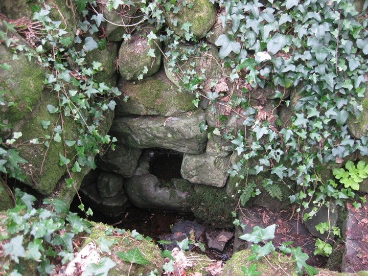
Holy or sacred wells don’t do well on TMA – they usually get the ‘of disputed antiquity’ tag – so when on reading in Gary Branigan’s book, The Ancient & Holy Wells of Dublin, that St.Mobhi’s Well near Skerries had a “number of cup marks present on some of the boulders, pointing to possible Neolithic origin” I had to pay a visit.
The site is marked on OS sheet 43 at the right-hand side of a track in Milverton Demesne. The entrance to this contains a stile, and indeed 20 yards to its right there is a hand-written sign that says “Please use the stile” attached to some barbed wire. This barbed wire blocks off the old pathway to the well. After traversing the stile you need to turn right immediately and follow the old path, not the seductive track that we were fooled into taking, thus having to climb a thorn-covered wall and cross the stream that flows beside the well.
The old well is impressively, even megalithically, constructed. The huge boulder at the back of the well-house rests on some stones like a portal tomb. This is the only boulder that we could find that had anything resembling cup marks. To quote the book again: “These cup marks are said to be the finger impressions of the mythical Fionn MacCumhaill when he threw these boulders from nearby Lusk.” Most of the rest of the other stones were covered in ivy so we didn’t find any more that had cup marks, but the ones that were most visible looked like solution pits, though it’s hard for me to be categoric about that.
The stairs down into the well are are well-worked flagstones. As you descend, there is a bullaun in a recess on the right-hand side. This is a craggy old, shallow-basined example but is said to contain the cure (for warts, toothache, headache and disorders of the throat).
As we arrived at the well a robin fluttered out from the main chamber of the well-house. This well-house is quite crudely (in the most gentle sense) constructed. The walls are of boulders and support a large, flat capstone/flagstone. This has then been covered over with larger boulders giving the well-house a conical shape. The water had leaf and other detritus so I didn’t fancy a taste.
This is a site well worth visiting, with relatively easy access and parking by the burial ground nearby. My instinct says that the construction around the spring of the well is not ancient in the TMA sense. However, there are two christian crosses here, carved into two separate stones and looking like a sly attempt to christianise the site. How will we ever find out its provenance? I guess the only way is through excavation, but the attendant folklore about Fionn, the supposed cup marks, and some of the methods of construction here leave one thinking of pre-christian possibilities.
... a ploughman was ploughing an area within the nearby graveyard, and was advised not to continue as it was holy ground. He responded by saying ‘St. Mobhí or St. Mobhó, I’ll plough my frough before I go’, at which point the ground opened up and swallowed him, with his horses and plough.
from: Ancient & Holy Wells of Dublin
by Gary Branigan
published by The History Press Ireland


The bullaun in the recess at the bottom of the steps. This is the water that has the “cure”
Kinda cheating here a bit as I didn’t actually visit the site – visiting strictly by invitation only. Lambay is meant to be rich in neolithic heritage – the site of an axe factory. Love to go there some day.