
Pano, showing quite a bit of the kerb, looking east.
Image credit: ryaner
Pano, showing quite a bit of the kerb, looking east.


Not much left, two sidestones and a capstone. I don’t think this was a portal tomb, maybe a small passage tomb.


Looking west. The cable doesn’t look strong enough to hold the stone up, but I guess that’s it’s purpose.

The sun sets over at Slieve Donard, viewed from the north-easternmost outlier at Ballynoe.
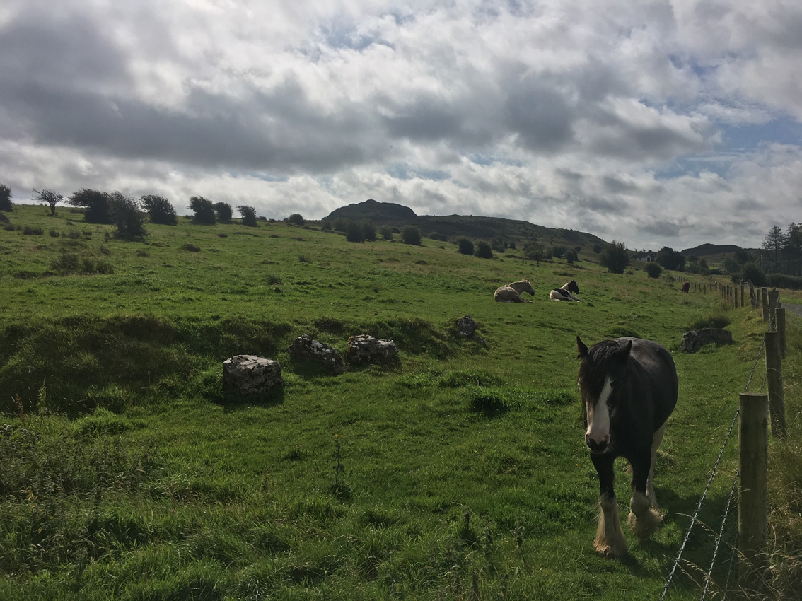
I found the stone pair in the graveyard up the road but couldn’t find this stone. There’s a new GAA ground in the place that it’s marked on the map, but the positioning could be wrong.

Secluded graveyard with ancient stone pair, north-east of Newry.


Stone pair at the back of a graveyard in Saval More.


The distinctive shoulder of the Barnmeen standing stone.

Barnmeen standing stone is 3 metres tall and a bit of a beast.


With the Sugar Loaf peeping over the horizon line on the right.


There was a fire on the Brakes in the summer but the gorse on the eastern arc escaped the flames. I had a root around under there today and you can see the stones that would complete the circle.


Corrig and Seahan at the other side of Glenasmole valley over the circle.


Beranger’s watercolour from the information board in the DSPCA.
YouTube report by thejournal.ie on the discoveries at Brú na Bóinne in summer 2018, with some good footage of the excavation at Dowth Hall.
Back in August, Cairn B atop the pudding-bowl hill in the distance.
Analysis of birch tar describes a female hunter-gatherer with dark skin and blue eyes
At the dawn of the Neolithic era, a young woman discarded a lump of ancient chewing gum made from birch tar into a shallow, brackish lagoon that drew fishers to the coast of southern Denmark.
Nearly 6,000 years later, researchers excavating the site spotted the gum amid pieces of wood and wild animal bone and from it have reassembled her complete DNA and so painted the broadest strokes of her portrait.
More: theguardian.com/science/2019/dec/17/neolithic-dna-ancient-chewing-gum-denmark?CMP=Share_iOSApp_Other
While the archaeologists have been busy finding new monuments of interest, the State has been busy facilitating their systematic removal
Mon, Dec 9, 2019, 05:00
Mark Clinton
According to the legal definition, there are five alternative criteria under which a monument qualifies as a national monument. Defying alphabetical order, “historical interest” is the first listed criterion. In 2003 the Carrickmines Castle site was recognised as a national monument before the Supreme Court. And now we are launching the history of the settlement and fortification, its long-term occupants the Walshes, their cousins in Shanganagh, Kilgobbin, Balally, etc, and, among many other players, that of the besieger of Carrickmines in March 1642, Sir Simon Harcourt. It is a colourful story, with a big finale. Truly, a site worthy of its national monument status.
And yet, the site, the national monument, is no more, save for some sad remnants, scattered about a busy roundabout. Ah yes, the Carrickmines junction. A junction not connecting with any national routes or, indeed, with a road of any significance. A junction whose planning origins remain unknown despite the best efforts of the Flood-Mahon tribunal. One of a daisy-chain of junctions along a motorway originally designed to carry national traffic unimpeded around Dublin city. A junction that effectively destroyed the integrity of the national monument. How did this happen?
The National Monuments Act, passed in 1930, brought legal protection to our ancient built heritage. On a number of subsequent occasions the Act was amended and strengthened to remove weaknesses and loopholes. Particular credit should go to former ministers Michael D Higgins and Síle de Valera for their significant contributions to the protective legislation.

Looking south at the northern side of the tomb. It would be quite a little charmer if it weren’t so overgrown.

Northern sidestone and capstone. Very hard to photograph properly.

The capstone has slipped from the portals and rests on the chamber sidestones.

West-oriented entrance with fairly well-matched portals. The northern portal is splitting vertically.


The northern sidestone looks like it has been smashed in the past.


Lichen-covered thorn trees envelop the scant remains of this diminutive portal tomb.

From in among the thorn bushes, a collapsed portal, a collapsed sidestone and a prostrate backstone are visible, along with the standing doorstone and portal.
Two stones are all the remain standing here, a small, just over a metre tall, portal stone and a doorstone.

Looking south-east at the mound that contains the overgrown dual court tomb.

The mound contains quite a lot of the remains of a court tomb, all of it hugely overgrown with most of the stones covered in ivy.

In Ballinamore golf club – cross the bridge and go left towards the first tee, and there it is.

Triple bullaun stone, happened upon as I was looking for the court tomb on the golf course.

An expert gasped when he saw coins unearthed by two men now convicted of theft
On a sunny day in June 2015 amateur metal detectorists George Powell and Layton Davies were hunting for treasure in fields at a remote spot in Herefordshire.
The pair had done their research carefully and were focusing on a promising area just north of Leominster, close to high land and a wood with intriguing regal names – Kings Hall Hill and Kings Hall Covert.
More: theguardian.com/uk-news/2019/nov/21/detectorists-hid-find-that-rewrites-anglo-saxon-history
Explore 6,000 years of human development
The heaviest intact prehistoric gold hoard ever found in Ireland has gone on public display at the
Donegal County Museum in Letterkenny.
More: rte.ie/news/ulster/2019/1119/1092820-donegal-gold-hoard/
A meeting of Sligo County Council has heard there is an incredible amount of damage being done to one of the most significant historic monuments in the country, the stone cairn over Queen Maeve’s grave on the summit of Knocknarea.
Sinn Fein Councillor Chris MacManus says a small number of people climb on top of the cairn while Fine Gael Councillor Sinead Maguire says people can be seen coming down the mountain carrying rocks from the cairn.
A local resident in the area also told Ocean FM News recently that some people have been digging up quartz stones from around the base of the cairn.
More (including a short poscast): oceanfm.ie/2019/11/12/conservation-plan-required-for-cairn-of-queen-maeve/?fbclid=IwAR1a2nXG8r302c0nimDg6CjVi-rTSgn2ZOhumlnKeEYZfIlfPttgmVOE-xA
The river bed of the Boyne is being searched by archaeologists.
ARCHAEOLOGISTS HAVE IDENTIFIED what could be Neolithic log boats as well as boulders, perhaps intended to be used in the building of Newgrange or Knowth, in the river bed of the Boyne, near to the famous monuments.
More: jrnl.ie/4878107
So there’s actually 10 basins.
Basin 1 : 0.27 diam x 0.05m deep
Basin 2 : 0.33m diam. by 0.16m deep
Basin 3 : 0.2m diam. by 0.05m deep
Basin 4 : 0.33m diam. by 0.15m deep
Basin 5 : 0.25m diam by 0.15m deep
Basin 6 : 0.32m diam by 0.13m deep
Basin 7 : 0.23m diam by 0.03m deep
Basin 8 : 0.3m diam by 0.13m deep
Basin 9 : 0.26m diam by 0.1m deep
Basin 10 : 0.18m diam by 0.04m deep

Sun starting to set as I approached the mound barrow from the south-east.

Looking north. The trig point is on the mound barrow. Like the other two barrows, this too is a grave, probably from the late bronze age.