
The northern barrow looking west into the setting autumn sun.
Image credit: ryaner
The northern barrow looking west into the setting autumn sun.


South-east over the bowl of the middle barrow with the Wicklow mountains in the far distance.

Looking south-west over the bowl of the middle barrow. The cattle and the people are over at the southern mound barrow.

The largest, northern barrow, looking north. It’s a fine monument and complete, but the gorse is encroaching from the west.

The bowl shape of the middle barrow looking east-north-east.

Looking south-east with the Wicklow mountains in the distance, this is a pano of the east to south arc of the largest of the three barrows.
The northernmost and largest of the three barrows.
From archaeology.ie:
Class: Barrow – ring-barrow
Townland: CARBURY
Scheduled for inclusion in the next revision of the RMP: Yes
Description: Towards the N end of Carbury Hill (0D 470 feet) and the northernmost of three closely associated sites; another ringbarrow (KD008-005----), c. 180m to the SW, and a possible mound barrow (KD008-003----), c. 360m to the SW, all excavated by Willmot in 1936 under a State financed scheme for the relief of unemployment (1938, 130-42 (Site B)). Only part of the central area and a section of the enclosing element at E were excavated. The grass-covered circular area (int. diam. c. 30m) was found to be defined by an inner, rock-cut fosse (Wth c. 4.5m; D c. 1.1m), and an outer ‘bank’ (Wth c. 4.5m; H c. 0.8m) constructed of broken stone and gravel, with a possible (but unexcavated) entrance gap at the NE. The central area was composed of a layer of decomposed rock (D c. 0.45-0.6m) and contained two postholes of undetermined function and nineteen burials. These included four cremations, two of which were disturbed, and fifteen extended inhumation burials, four of which were children, and some of which contained the remains of more than one individual. The cremations appeared to precede the inhumations and one was accompanied by two iron rings and a pin-shaped fragment of iron. All the inhumations had their heads placed towards the SW, and one was accompanied by an iron shears. Other finds included flint scrapers and knives, a stone disc, a sherd of pottery of undetermined type and a ‘bronze knob’. The two burial rites suggest a long period of use, perhaps spanning the Late Bronze Age/Iron Age period. The monument was subsequently restored to it’s pre-excavated morphoplogy.
Compiled by: Gearóid Conroy
Date of upload: 10 June 2011
The middle of the three barrows.
From archaeology.ie:
Class: Barrow – ring-barrow
Townland: CARBURY
Scheduled for inclusion in the next revision of the RMP: Yes
Description: Some 180m NE of the summit of Carbury Hill (OD 470 feet) and the central of three closely associated monuments; a possible mound barrow (KD008-003----) c. 180m to the SW, and a second ringbarrow (KD008-004----) c. 180m to the NE, all excavated by Willmot in 1936 under a State financed scheme for the relief of unemployment (1938, 130-42: Site A). A circular area (ext. diam. c. 26m) was defined by an inner, rock-cut fosse (av. Wth c. 2.4m; D c. 0.45-c.0.9m) and an outer ‘bank’ (Wth av. c. 4.8m; H c. 0.6m) constructed of broken, rubble limestone. Opposing entrance gaps occurred at NW (Wth c. 3.65m) and SE (Wth c. 2.4m) and were matched by corresponding, undug, causeways across the fosse. The circular interior (diam. c. 11.6m) was covered by a layer of broken rock (D c. 0.3m) and contained a centrally placed cremation. A second cremation was found in the fosse at N. Finds included eight worked flints, a spindle whorl, two sherds of red ‘gritless’ pottery, a jet spoon, an iron file and a fragment of fused blue glass. An Iron Age date was suggested for the monument, which was subsequently restored to it’s original morphology.
Compiled by: Gearóid Conroy
Date of upload: 10 June 2011
The southernmost barrow on the peak of Carbury Hill with the trig point.
From archaeology.ie:
Class: Barrow – mound barrow
Townland: CARBURY
Scheduled for inclusion in the next revision of the RMP: Yes
Description: On the summit of Carbury Hill (OD 470’) and the southernmost of three closely associated sites; a ringbarrow (KD008-005----) c. 180m to the NE, and another ringbarrow (KD008-004----) a further c. 180m beyond to the NE, all excavated by Willmot in 1936 under a State financed scheme for the relief of unemployment (1938, 130-42. (Site C)). A small, circular, grass-covered mound (diam. 8.2m; H. c. 1m) had a slight depression on it’s upper surface and had been used for bonfires in the past. The mound was composed of rock rubble mixed with earth. A small rectangular hollow (dims. L c. 0.3m; Wth c. 0.2m; D c. 0.25m) in the bedrock beneath the mound contained the cremation of a juvenile. No grave goods were found but its prominent siting might suggest that it was the earliest of the three monuments here and may date to the Late Bronze Age. The monument was subsequently restored to it’s pre-excavation shape.
Compiled by: Gearóid Conroy
Date of upload: 10 June 2011
From archaeology.ie
Class: Cairn – unclassified
Townland: HOWTH
Scheduled for inclusion in the next revision of the RMP: Yes
Description: Located on the summit of Kilrock on Howth Head. This is a circular round-topped cairn (diam. 6.5m; H 2-2.5m). There is a great deal of shattered stone visible on the surface. Kerbstones are visible along E and SW. A trignometrical station is marked at this point and there is the possibility that the cairn was constructed for this purpose. Spectacular views north to Ireland’s Eye and east coast.
Compiled by: Geraldine Stout
Updated by: Christine Baker
Date of upload: 29 January 2015
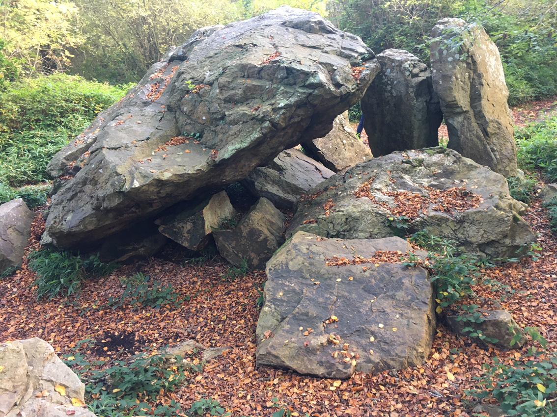
The heavy end of the now collapsed capstone rests solely on the eastern portal stone. The doorstone and the western portal stone stand pretty much as they would have before the collapse. The eastern portal is tilted way to the east, pushed backwards by the capstone but not in its way so much that it snapped.

Some have said that they doubt that the 80 ton capstone was ever raised onto the chamber. It’s such a monster stone that they might have a point, the portal stones are over two metres tall, the technology didn’t exist – but oh ye of little faith, we have seen far greater constructions, and even though it would have been an immense undertaking, this snapped stone shows the power of the collapse, imho.

The ever majestic, if collapsed, Howth Demesne dolmen.


The curious arrangement at Kilranelagh Graveyard.

Looking smart on an overcast day in late September.

The larger northern cairn with the Great Sugar Loaf looming.


The larger cairn looking west. The smaller southern cairn is at the very left of the shot.

Pano looking north from the summit of the Great Sugar Loaf. The cairns are just below dead centre of the shot.

Quartz block at the bottom right on the smaller cairn.

The Great Sugar Loaf looms over the smaller southern cairn.

The northern, larger cairn, looking north. Howth peninsula lies on the horizon line across Dublin Bay above Dalkey head.

Re-discovered in 2003, this stone “may have been covered by brambles for a number of centuries.”
From the Castletimon Heritage Trail sign:
Legend says that the Ogham stone was once picked up by the Castletimon Giant and was thrown down the hill and the scratches on it were left by his fingernails.
Also... There was once a man who lived near the Ogham stone who took it from its place to use it as a hob stone. The fairies got so angry they made his cutlery dance and jiggle. After a week of this he got so annoyed he took it back to its original place.

No. 2 on the Castletimon Heritage trail, I can’t find a name for the hill in the background.
At the north-west corner of the field there is a service entrance to Punchestown racecourse. The gate is sometimes open but if it isn’t there is a hurdlable wall. Over this and back into the corner, the fence into the pasture field that holds the stone is easily surmountable. The hedging and fencing that line the road are impossible. (If you’re not into leaping the medium-difficult wall you can walk up to the actual racecourse entrance a couple of hundred yards up the road and come back to this point. The racecourse allows dog-walkers and strollers and is a popular amenity for the denizens of Naas up the road)
There is a footworn track from the field corner to the stone so people are still determined to visit despite the obstacles. The stone itself is magnificent, the views north blocked but those south-east towards the Wicklow mountains fine. An old info sign has been trashed and thrown into the battered enclosure, the cement that holds the stone up after it was re-ercted in 1934 visible but not too obtrusive.

Looking south-east towards the Wicklow hills.

It looks quite slim from this angle.

Punchestown standing stone, 7 metres tall.

Not a bad little site, this pano view is looking south-west.

Looking west. The trees are on the top of the mound, ditch visible to the right.

Looking south. Still no effort to do anything with this.
Facing the stone with the racecourse entrance at your back, look to the right and there is a gap in the hedge. Over the fence into the neighbouring field and then through the ungated entrance. The hurdle of the fence is low to medium difficult.
The stone sits atop a slight ridge, over 4 metres tall and leaning to the west. It still has its original packing stones, continuing to do their job down through the millenia. Views all around are pleasant if unspectacular but this is still an essential site if your’re in the Dublin area.


An impressive, Brittany-style menhir.


Kerbstones on the north arc of the cairn show that, even at this isolated spot, material has been robbed from the monument.

The cairn is not on the highest point of Carnawaddy. This is taken from the peak looking back north-west.

From the north-western shoulder of the cairn, with Warrenpoint down at the mouth of the Newry River as it emerges into Carlingford Lough.


