
ryaner

A few bits of kerbing and some scattered stones are all that’s left of R2.
Image credit: ryaner


Possible cup and ring mark from the inside of one of the kerbstones on the north-east arc of cairn S.
Image credit: ryaner
There are some sites that hold an enduring fascination, even though, because of their ruinous condition, they are well past their sell by dates. It could be their location, or the tantalising tales of what once was, or it could be a je ne sais quois, a more regular feeling about a lot of these places. It could also be the grim determination that one feels, that no matter what remains and no matter how insubstantial it is, we will bear witness, gripped as we are by endless curiosity, nagging impulse and barmy nerdishness. It could be any, or all, like Rush today, of these.
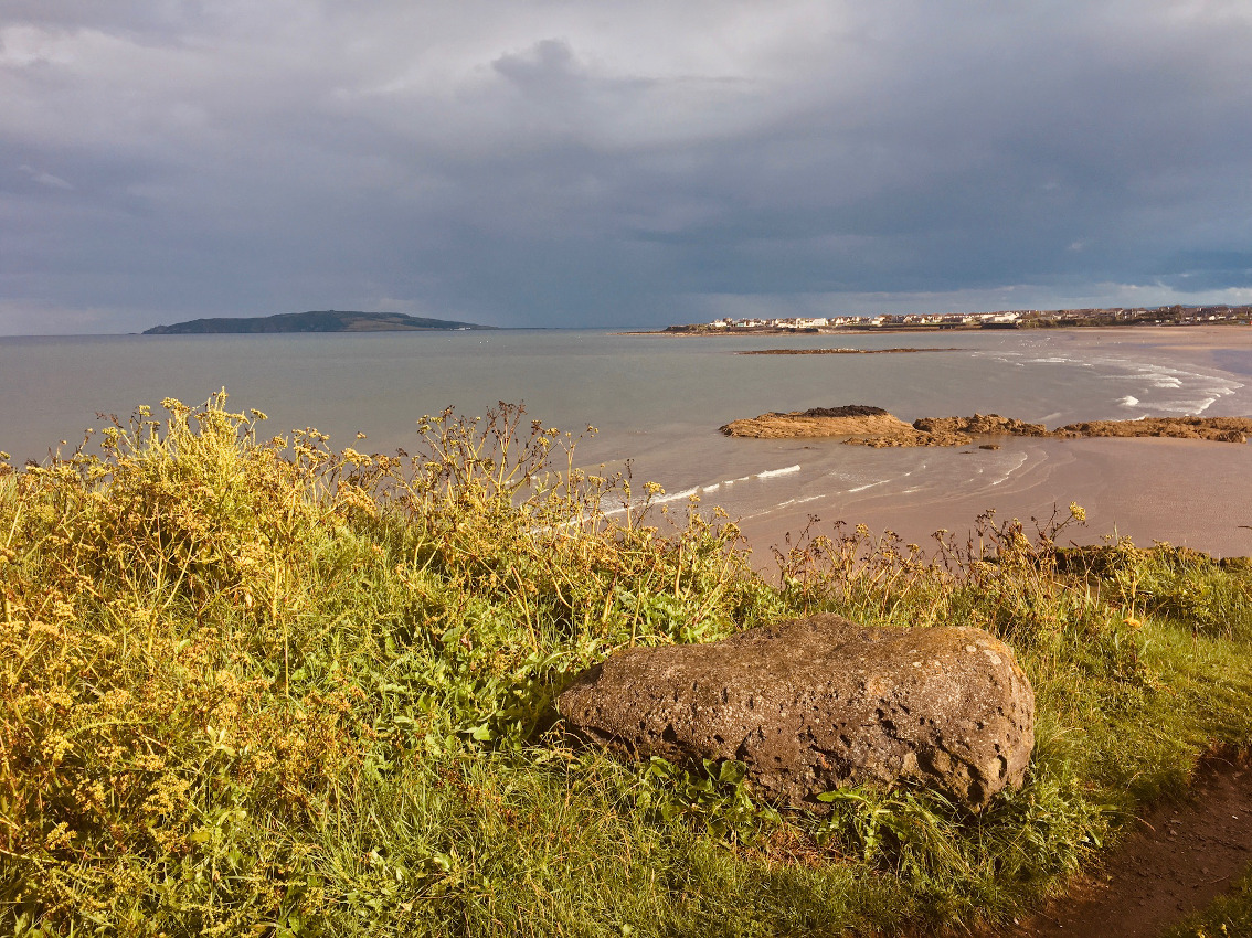
Drive or walk north out of Rush village (now an ever-expanding town) on the Skerries road and the first turn on the right is Six Cross Lane. This leads down to the north beach of Rush with its caravan parks and holiday homes. Take this, the more adventurous route, to access the site (There is a track 150 metres further north that leads to an easier route, but it was waterlogged and muddy today and was only suitable for wellies, not my cheap Lidl walking boots).
From the north beach, walk north towards the promontory where the remains lie, rounding a small headland and fording the stream that flows through the deep gully. You can ascend, with mild difficulty, the path where the stream meets the beach. Follow the track past the cabbage fields, east onto the promontory and skirting the cliff-edge and there you have it.
It’s true that keeping one’s expectations low seldom leads to disappointment, and from reading the various sources, I wasn’t expecting much. There are more remains here than I have read about in any of the mentions I’ve found, but when one reads that this was a conical mound, thirty metres in diameter with a ten metre long passage and a 2.4 metre long chamber, one realises that these remains are scant indeed. But today is really about location and sensation and determination and relief.
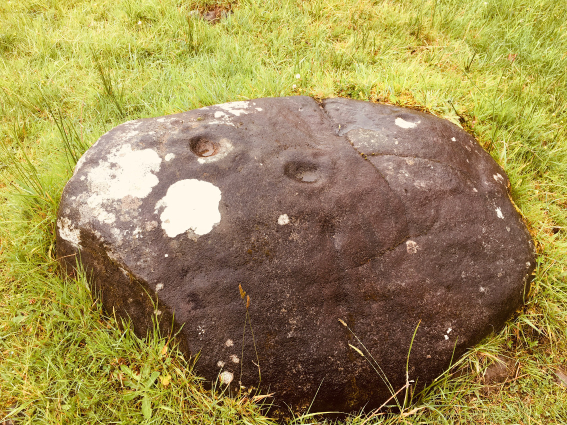
Three contiguous stones still stand in the undergrowth and cairn rubble that separates the penultimate field of the small promontory from the field beyond. They look like kerbstones. It’s not much to hold on to, they’re not mentioned anywhere else, but there they are. Just over the rubble in the corner of the last field, beside the track, lies a large, loose boulder, said definitively to be from the the tomb. Were this all that remains, other than the written words of what once was, disappointment may have sunk in, but no – what is here ought to be examined and preserved, but probably won’t.
I’d been up the road in Skerries earlier and had gotten lashed on. The two sites I’d visited there deserved more attention than I’d managed, but here the sun had emerged. I’d almost given up when I’d seen the waterlogged, muddy track, had returned to the car and started to head for home. Then the pull kicked in. Fuck it. I turned the car around and sought another route, not fully believing there was a way, but there was a will.
Herity says that the mound “had been more than half-destroyed when W.P. Newenham saw the site in 1838.” I’ve driven past the location many a time and wondered was the whole thing just wiped away, pulled apart and ploughed into the ground. Well not all of it. There are traces still, tantalising, like the sensation one has looking across to distant, private Lambay, just out of reach but still possible. The colours of the day were emerging from the greyness that has dominated this last four or five weeks of this unique pandemicked summer. Sun was breaking through as the rain fled across the Irish sea and I didn’t want to leave but had to.
From the SMR at archaeology.ie
Class: Megalithic tomb – passage tomb
Townland: RUSH
Scheduled for inclusion in the next revision of the RMP: Yes
Description: Situated on a small headland south of Loughshinney village. Prior to c. 1838 the site comprised a circular cairn (diam. c. 30m) with a funnel-shaped entrance and a rectangular chamber (L 2.4m; Wth 1.8m). Human bones were found in the chamber and midden material containing a possible microlith (DU008-013003)-) was found underneath (Newenham 1838, 247; Flanagan 1984, 15). Two cist burials were found in the cairn and a third W of the kerbstones (DU008-013002-).The cairn was partially removed by land improvement in 1838, the remainder incorporated into a field boundary. Remains of this field boundary extend almost from the cliff edge for c. 21m NS. Large stones (> 1m diam.) and small stone cairn material are visible within the overgrown field boundary. One large boulder is out lying c.2m south-east of the field boundary. No markings or decoration visible on these stones. Magnetic gradiometry undertaken by the Discovery Programme (Licence 08R247) did not succeed in establishing a location for the passage tomb as a large part of the area had been subject to intensive ploughing.
Compiled by: Geraldine Stout
Updated by: Christine Baker
Date of upload: 15 December 2014
Lambay Island with its cairn and axe factory away to the south-east.
Image credit: ryaner


The stone on the left is thought to have come from the tomb. Like the cliffs here, there are many geological curiosities in the area.
Image credit: ryaner

Three possible kerbstones with Lambay Island in the distance.
Image credit: ryaner

The dark green area in the middle distance contains the remains of the tomb.
Image credit: ryaner


Looking north-west back to the Lusk to Skerries road.
Image credit: ryaner


Shot taken from below the cairn to the north-east. I’ll come back some day and get some better shots.
Image credit: ryaner

Quite substantial remains. Apologies for the terrible photograph.
Image credit: ryaner
Tullygobban (Tulaigh an Ghobáin) is though to be named after the Gobán Saor, the master craftsman of Irish folklore. His wife and child are thought to be buried on this hill.
Snails have shown an ancient naked figure sculpted into a chalk hillside is unlikely to be prehistoric as hoped, archaeologists have said.
Tests of soil samples extracted from Dorset’s Cerne Abbas Giant to determine its exact age have been delayed by the coronavirus epidemic.
They are not due until later in the year.
However, land snail shells found in the samples suggest it may date to medieval times, separate tests have found.

7/7/2020, after a visit to the Stairway to Heaven.
Image credit: ryaner

The ‘decorated stone’ in Marlbank nature reserve.
Image credit: ryaner

Standing on Raven’s Rock looking north with the pair of stones 30 metres away. The stones are 24 metres apart.
Image credit: ryaner


Looking north over the eastern stone towards Two Rock and Three rock mountains in Dublin.
Image credit: ryaner

The eastern stone, with the western off its tip in the near distance.
Image credit: ryaner

The eastern stone, larger and bulkier, with the Great Sugar Loaf and, to its left, the Little Sugar Loaf.
Image credit: ryaner


Looking south at the western stone with in the distance Djouce Mountain towering over Maulin, War Hill and Tonduff.
Image credit: ryaner

The western stone with the eastern on the horizon line.
Image credit: ryaner

Quarry marks evident on the stone in the foreground.
Image credit: ryaner

Looking back west towards Prince William’s Seat.
Image credit: ryaner

Looking east towards Raven’s Rock with the Great Sugar Loaf in the distance.
Image credit: ryaner

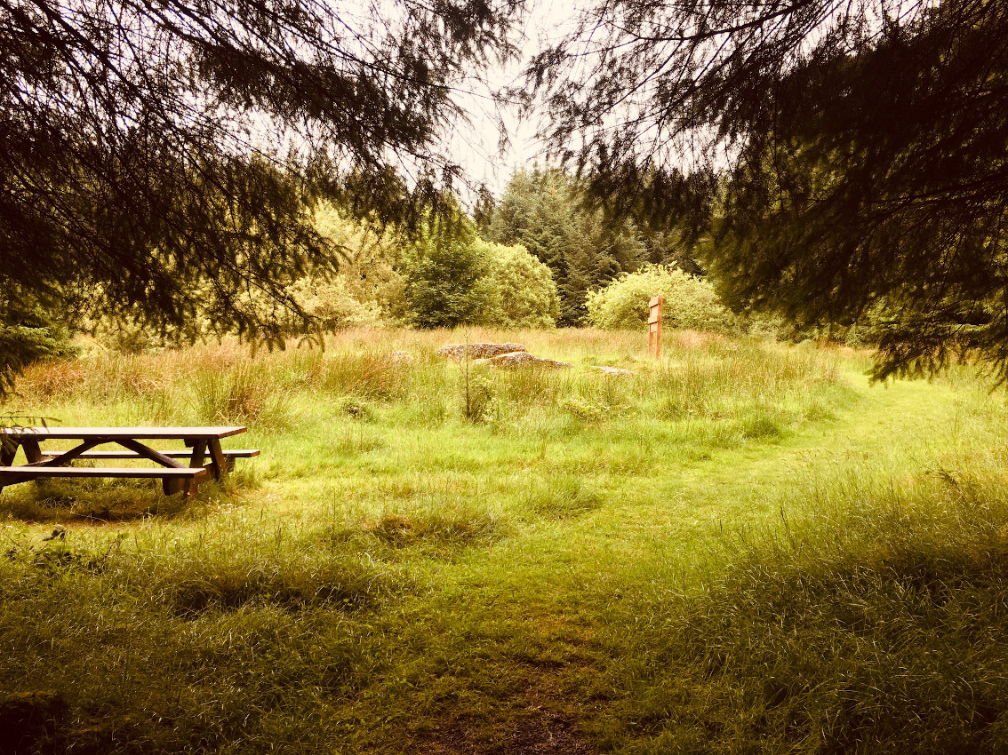
The view as you first approach the tomb from the Giant’s Grave Loop Walk. Picnic table and info sign and all.
Image credit: ryaner

The ground fall away just beyond the furthest stone, down to a small stream.
Image credit: ryaner

The stone on the right is the only one still in its original position.
Image credit: ryaner

This monument is not in the Archaeological Inventory of County Cavan, published in 1995.
This is the entry on archaeology.ie:
Class: Cairn – burial cairn
Townland: POLLAKEEL (Upper Loughtee By.)
Scheduled for inclusion in the next revision of the RMP: Yes
Description: Located on top of Slieve Glah. A trig. station is constructed on top of a grass-covered cairn (diam. 13m; max. H 3m) that has been partly quarried, but there are indications of a small rectangular cist in its upper surface. It was reported by Michael Gibbons and Jim Higgins.
Compiled by: Michael Moore
Date of upload: 21 May, 2019

The Banagher complex is in the field on the right at the top of the low ridge in the middle distance. This shot is taken from a meadow 50 metres southeast below the summit cairn on Slieve Glah.
Image credit: ryaner

Trying to get as much of the circle in here. The lush summer grass didn’t help, but I wasn’t complaining.
Image credit: ryaner

Another of the 5 still standing stones from the circle.
Image credit: ryaner

Probably natural solution pits on a kerbstone of the passage grave.
Image credit: ryaner


One of the 5 remaining upright stones of the large circle.
Image credit: ryaner

Chamber of the passage grave, taken from on top of the Fógra. The henge/enclosure is visible on the right middle distance.
Image credit: ryaner

Looking south-west over the disturbed top of the 3 metre tall cairn with Ardkill More hill in the distance.
Image credit: ryaner


Grass and heather covered cairn in Pollakeel townland on the peak of Slieve Glah.
Image credit: ryaner