ryaner

ryaner

All posts expand_more 1,801-1,850 of 6,341 posts
Image of Slievefoore (Cairn(s)) by ryaner

Slievefoore

Cairn(s)

More quartz peeping through the turf. There’s lots of it here. The area around the entrance to the foresrty about a kilometre away is known locally as the White Heaps “due to the cairns of quartz which may have marked prehistoric burial mounds” according to the notice board there.

Image credit: ryaner

Carrickclevan

This took a bit of finding, not wholly unsurprising at this time of the year. We parked up the way of the cul de sac and walked a couple of hundred metres. A farmer and his son were harvesting in the field we needed to traverse and he was very happy to allow us head over to the tomb. His directions of “off up to the right” were as helpful as trying to use the old OS map, but in the end he was right, just that the tomb was on the wrong side of the hedge and completely overgrown on the side from which we approached.

It’s a little gem really. Leaving aside it’s overgrown state and the fact that some of the trees may eventually collapse the whole structure, there’s quite a lot left. Both portals, both sidetones and most of the capstone are extant, if not in their exact original position. The southern portal and sidetone are both leaning inwards. The large capstone, estimated at 6 tons (see folklore below) has had a portion snap off at the rear of the chamber where the backstone seems to be missing.

Opened up and allowed to breathe a little, Carrickclevan would be by no means a spectacular, show site – it’s not even head height. Which is not to say that it couldn’t do with a bit of love – it squats there, almost as an afterthought, slightly shamefaced, cowering beneath all that vegetation. After spending a bit of time we left, happy to have found it, almost lost and unloved, but now re-discovered.

Dunsany

Opposite the entrance to Dunsany castle, at the foot of a christian cross is this quite peculiar stone. The two bullauns are fairly shallow, in comparison to most, and there are said to be more cup-like depressions that I didn’t notice. The stone itself is almost square-shaped and has been fractured in a couple of places down through the years (or the millenia). The white lichen almost covers the entire surface and makes it hard to examine. An oddity.

Derrynavahagh

The Caher river valley runs roughly north-south through the townland of Derrynavahagh. North of the townland there is a crossroads in Formoyle East where the Burren Way crosses, having descended from the northern slopes of Sliabh Eilbhe, heading east towards Gleninagh mountain. We had been further back along the Way earlier at Ballyelly enclosure and wedge tomb, but had spun our way around back up through Fanore and onto the Caher Valley road. I had kind of a loose plan that had gone out the window a few sites back so here we were, south of the crossroads, in the thick hazel scrub that has colonised so many parts of the Burren.

There is probably a better, safer, easier way to Derrynavahagh wedge tomb, south from the Burren Way perhaps, across the limestone pavement, but hindsight is a great thing. Right now I had a carload of barely interested teenagers and a half-interested friend, and even though Derrynavahagh is one of the finest examples in the Burren, I was close to giving up when I asked, “well, are yous up for it or what?” Up for it, as it turned out, was climbing up from the road south of the crossroads, after we had found a spot where the scrub had thinned out. After a few shrugs, and a sort of explanation of what ‘it’ entailed, we headed up.

The Burren terrain rises and falls in a series of terraces. Often the climb from one terrace to the other is only 10 metres. From what I could make out from the satellite photo I had (ah the pleasures of modern technology), we’d have a series of three climbs and a half a kilometre of a walk over varying ground. The ascent from the road to gain the first scrub-covered terrace was the hardest. The second ascent left us on our first bit of raw limestone pavement. This is what the Burren is really about and my companions were delighted. I headed for the third ascent and over to the tomb.

It’s semi-surrounded by a modern stone wall and is a stunner. Largely intact and isolated, it’s kind of an introverted megalithic explorer’s ultimate dream. It has the wedge shape, take-off and landing-strip profile that we all know and love. The massive capstone has broken at the rear of the chamber and doesn’t reach the backstone. There are a couple of slabs lying around that are or were part of the tomb but I couldn’t make out from whence they came. The triple walling on the eastern side is phenomenal, with the 2 metre tall standing stone beyond the chamber opening almost like a sentinel standing guard.

Aside from the magnificence of the tomb, the location has to be commented on. To the east the ridge rises towards Faunarooska townland with its three ruined tombs. West and south-west across the Caher river valley is the broad expanse of Sliabh Eilbhe, with its craggy terracing. North towards Black Head is Gleninagh mountain. It’s an area rich in isolated wonders and, without sounding like a tourist rep. or salesman, one could spend weeks here, lost in the mesmerising views both near and far, endlessly pondering the beauty and magnificence of the world.

Image of Carrickclevan (Portal Tomb) by ryaner

Carrickclevan

Portal Tomb

The view out from the back of the chamber. You can see where the southern portal on the right has started to fall. The southern sidestone is leaning inwards quite badly too but that proved impossible to photograph on this day.

Image credit: ryaner
Image of Carrickclevan (Portal Tomb) by ryaner

Carrickclevan

Portal Tomb

A portion of the capstone has snapped off at the back of the chamber, presumably along the lines of a natural fracture that came into play as the stone slipped off the backstone (total speculation).

Image credit: ryaner
Image of Ardsallagh (Bullaun Stone) by ryaner

Ardsallagh

Bullaun Stone

I think many of these were originally earthfast and were broken when they were dug up. Not saying this is definitely what happened here, but you just get that feeling.

Image credit: ryaner

Callaigh Berra’s House

I’ve been to Calliagh Berra’s house and lake 5 times, I think, and never written about it before. It’s well covered elsewhere and I haven’t felt the need. Experiences today, and newspaper reports, have given me second thoughts, so here goes.

The Ring of Gullion caldera itself would be impressive and worth a visit even without having one of the highest passage graves in Ireland, plus the lake, plus the second cairn. Then there’s Ballykeel dolmen to its west. So it’s a bit of a draw really, and not just for stone heads. Slieve Gullion forest park is a major attraction, with playgrounds, a café, various trails and easy access. Out of season, however, the crowds thin out, and there was no-one around on the snowy, January day I visited in 2016. Not today alas.

The car-park on the western shoulder that Gladman mentions below is still there. I’ve used it on all the occasions I’ve visited. It’s on close to the 350 metre contour, thus leaving you about a 226 metre climb. You could start from the car-park at the forest park centre, about a four kilometre walk below at the 120 metre contour, but I’ve always had the car and never felt the need.

The ascent to the summit and the cairn is quite strenuous but is now along a stone and gravel track. Access has been opened up and at many of the steepest parts the track turn into stone stairs. Work on this is ongoing and they’ve even gone as far as creating a track across the boggy top of the mountain, over to the lake and the second tomb.

All of this positive work does have its downside however. The erosion around the tomb is increasing. In fact, all of the top of the mountain is suffering. Who am I to complain about this? I get out as often as I can and how can we enthusiasts separate ourselves from the general mass of the populace seeking the benefits of the great outdoors?

And what of the tomb itself? It’s not the ultimate destination of a lot who come here. It seems to me to be an afterthought to most, a bunch of rocks without too much meaning other than vague notions of times past. Which is maybe its saving grace – most don’t bother too much with it, taking the odd selfie, clambering onto it and into it and leaving not long after. And then there’s the cohort that stick around a bit longer, maybe have a few beers and a few spliffs, who knows, maybe light a fire and fuck around a bit, carving names or initials into the rocks in the chamber, generally getting shitfaced and not giving too many fucks about anything. Been there, done that.

It’s been on my mind a bit, this general disregard for, and the popularising of, these places – and not just because it’s in the papers. I’ve been to some sites this year that have been trashed and I have felt caught between two stools. On the one hand I’m an enthusiast that photographs these places and put the results on an open website, partly guilty of the very popularising that I sneer at. And on the other, when I see these places restricted, like the cold houses of Knowth and Newgrange, I bristle.

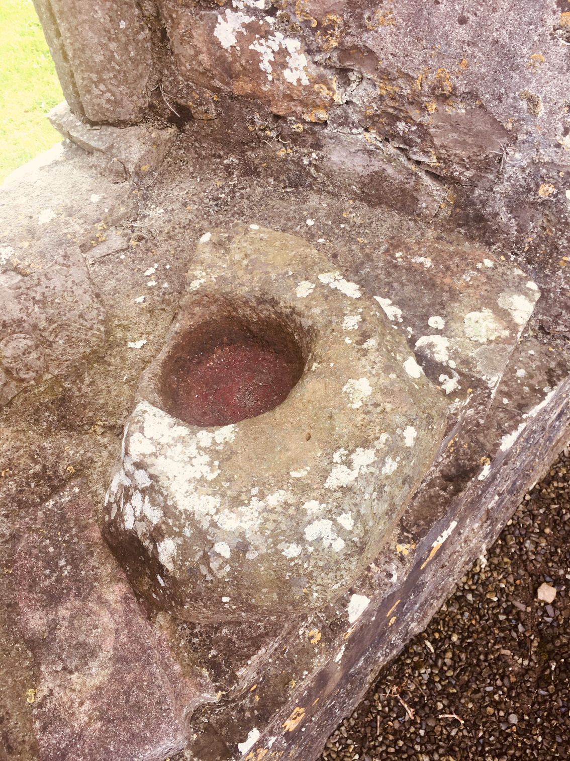
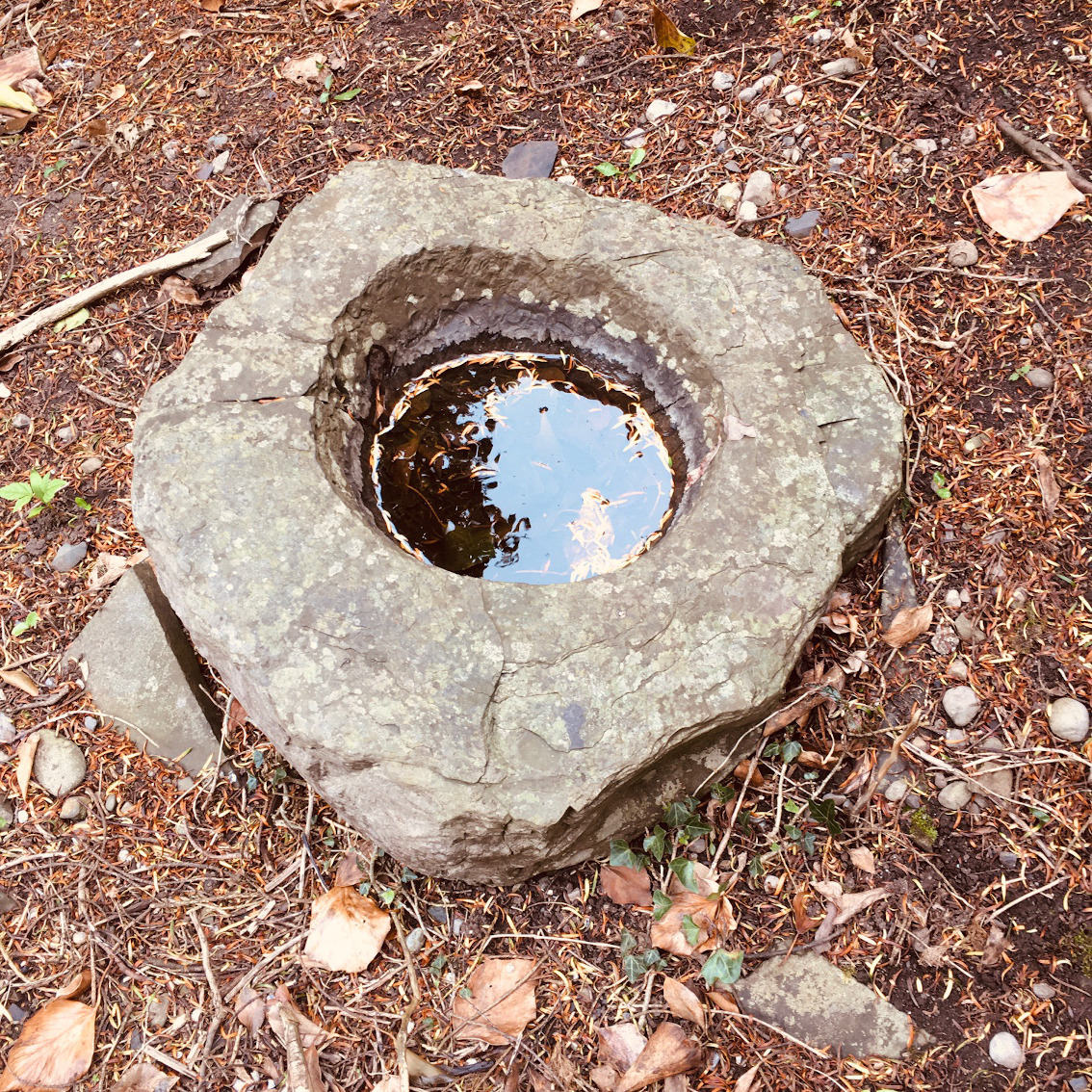
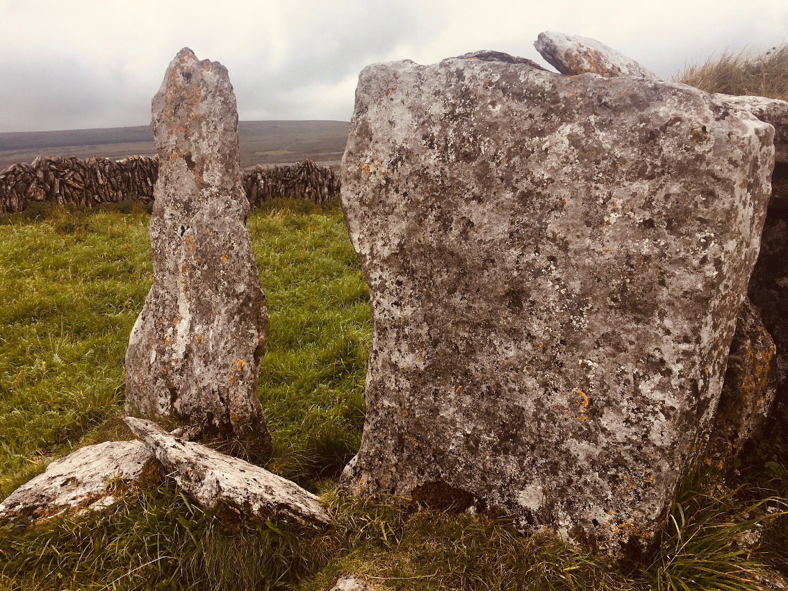
I love Calliagh Berra’s house, even with its fake ass roof. The thunderously clunky construction of the chamber, the inexpert basin stones, the lintel over the passage entrance, the passage itself with its massive horizontal ‘orthostats’ and the quite massive cairn, all together make this tomb unique in passage grave-dom. We sheltered from the mini-storm back that day in 2016, in the mother’s womb, and were grateful. But this may be a luxury in the future. The general disregard of, even the vandalism and trashing of these places may end in them being closed to everyone. And in the end, who could argue with that?

Ballyelly

About a kilometre south of Fanore Beach a road climbs the lower northwest slopes of Sliabh Eilbhe in an almost southerly direction. This road meets the Burren Way walkers’ trail at Balliny North after about 2.5 kilometres. You can park here. Head back in a northeasterly direction along the Burren Way. The track is well walked and popular. It’s in that part of the Burren where there is still a thin cover of soil and vegetation, more dangerous for traversing than the denuded parts as the cover tends to hide the grykes that can result in a snapped ankle.

The walk to the enclosure, tomb and the hut site is about 2.5 kilometres of leisurely trekking. The stones and condition of the enclosure walls and the hut site are similar to those of the shattered and collapsed tomb. This could lead one to believe that they originate from the same era. I like to think that there was a bronze-age smallholding here which included the wedge tomb.

There’s not much to say about the tomb itself. It’s in a very collapsed state, but both sidetones seem to be there, along with a couple of roofslabs and a possible backstone. It is typical of the Burren wedge tomb class.

We spent a while here in the welcome but intermittent sunshine. The Burren terrain, like the Aran Islands to the west, seems to suck the noise of the world out of the atmosphere, enclosing the spirit in a bubble of peace and eeriness. We investigated the clochán about 250 metres to the south-east and then headed back to the track via the enclosure.

Image of Derrynavahagh (Wedge Tomb) by ryaner

Derrynavahagh

Wedge Tomb

The side-walling on the east side of the tomb. I don’t think the slabs covering the gap from the roofstone of the chamber to the outer walling are original.

Image credit: ryaner
Image of Derrynavahagh (Wedge Tomb) by ryaner

Derrynavahagh

Wedge Tomb

The backstone of the chamber is in the middle of this shot. The tomb continues back from this for about another 3 metres and may contain another, smaller chamber.

Image credit: ryaner

Baur South (Cl. 26)

So I finally got to this one, Baur South (Cl. 26) for us pedants. I’d been in the area three times previously and always lucked out. Not this time mofo. What can I say about the Historic Environment Viewer at archaeology.ie except that it’s the coolest, most valuable thing on the www for Irish archaeology heads (and guess what: there’s now a Historic Environment Map Viewer for the six counties).

Heading north-east from the Lissylisheen/Cahermacnaghten area you emerge from the Hazel scrub as the road veers directly east. Stop here. There’s a boundary wall that seems to continue from the west side of the road over to the east. Walk back west and the tomb is north of this wall, about 250 metres from the road.

The 1961 photo of the tomb shows it in a typical craggy Burren field, open to the air and able to breathe. Alas no more. It’s now coralled within a copse of the dreaded hazel scrub, inundated with vegetation that teemed with midges and flies on the last day of July. It’s kinda sad and a tad frustrating.

Still and all it was a treat. The box within a box doesn’t make any logical sense. No harm there. The outer ‘skin’ is said to have the remains of more outer walling, but this, and the transversely set entrance stones, were not visible in its present condition. We didn’t stay long, attacked by swarms of insects, and with the hunger growing on us from a long day out, we fled down the road to Poulnabrone, civilised and staid, and then back to reality.