
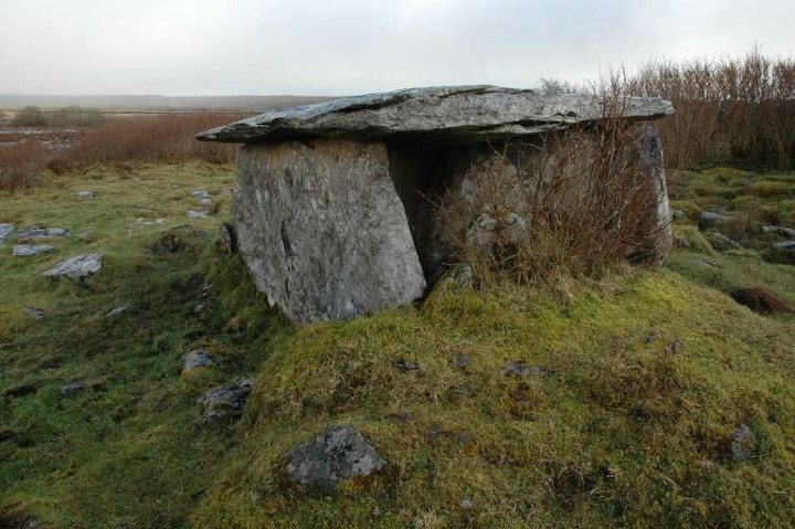
The less well-known and very ruined wedge tomb in the central part of Burren. This would have been as impressive in its day as ‘The Giant’s Leap’, Burren East wedge tomb.
Image credit: ryaner

The less well-known and very ruined wedge tomb in the central part of Burren. This would have been as impressive in its day as ‘The Giant’s Leap’, Burren East wedge tomb.

One of the new signs that are all along the path through the forest on Burren


Cup and ring marks. These alone are worth the trek up here.


The showpiece tomb at Burren. A truly moving and inspiring piece of megalithic engineering.
A truly impressive bullaun stone, nestled in against a field boundary and a stone’s throw away from the shore of Lough Macnean Upper. Park at the modern graveyard 100 metres east from the signpost to Killinagh church and walk back. The stone is past the church and old graveyard down near the shoreline.
There were some ‘offerings’ placed under the turnstones in the bullauns. We cleaned some of the detritus that is moulding away on and around the stone, but brambles have taken hold in the space between the upper surface and the lower.
Through swallow holes on Cuilcagh (Binn Chuilceagh), water drains down off the mountain and rises here at the Shannon Pot. It’s quite an eerie place to pass some time, watching the water swirling up from underground and then rushing out of the pot and heading south to eventually empty into the Atlantic at Limerick. Well signposted on the Blacklion to Glangevlin road, there are car-parking facilities and a new pathway that allow anyone to have access to this quite magical spot.


21/1/07
There are about 20 faded cup-marks on this stone

Fallen standing stone, with Ogham script holding out against the elements

This souterrain is built with a large degree of skill and snakes its way into the mound/rath/cashel. We found this easily the most impressive of the structures at Poulawack.

The remains of the roof of the entrance. The cairn can be seen in the distance
150 metres north-east of the of the main cairn at Poulawack are the remains of another small burial cairn. Rising to a little over a metre, it’s a robbed out ruin. Estimated diameter is about 10 metres. At the centre of the mound there are the remains of a burial chamber/cist, with some of the orthostats still in place on the east side. It’s hard to guess the dimensions of this due to the infill. On a drizzly, January day we wondered who it was that pulled this mound apart and what they were looking for.


From on top of the mound you can see the remains of a burial chamber

The slight rise in the middle of this shot are the remains of the cairn/mound
There is now a turnstile-type gate and three information boards at Poulnabrone. The pathway from the road to the tomb looks and feels unfinished. How many of the million-a-year visitors that the Cliffs of Moher get stop off here? There were 2 tour buses here the day we arrived, late January, when most of the Burren facilities were closed down. We waited for them to leave and had the monument to ourselves.


Looking SSW. The wooded area to the right of the tomb contains the remains of very many more megalithic tombs

The broken down remains of the 2nd wedge tomb at Gleninsheen. You can just about make out the better preserved one in the top left of this shot.
Slight remains of the mound at the rear (western end) of the tomb

Very well preserved wedge tomb, almost geometrically perfect in its construction and quite a bit odd for that reason.
Liam Price mentions 3 bullauns in his notebooks:
29th October 1933
“The top of the hill (1171ft) is called ‘the Whistling Bank’. Further W than the pond near Johnny McDonnell’s house (which was previously Farrel’s) are three ‘bullaun’ stones, all granite blocks, natural boulders. The first has three bowls: two of them 13in. each in diameter, and 7 and a half in. and 8 and a half in. deep respectively: close together, rather vertical sides: the third is very shallow – 10in. diameter, 1in. deep: like a place where a bowl was started.”
From: The Liam Price Notebooks – The placenames, antiquities and topography of County Wicklow. Edited by Christian Corlett and Mairéad Weaver. Published by Dúchas The Heritage Service.


A 3 basin bullaun that’s not marked on Sheet 56. Take the road south from Oldbridge to Laragh. After about a mile the road dips where Keocha’s Brook passes under the road. 10 metres before this on the right-hand side is a gate into a large, sloping field. Walk west through here just above the brook for approx. 500 metres. The stone is there in the corner of the field.
It’s a large lump of a rock that may have been previously earthfast. It reminds me of Clonmore bullaun stone: themodernantiquarian.com/site/935
Two of the basins are over a foot in diameter and quite deep. The other is very shallow, maybe the beginnings of a forgotten project.
For more on this see miscellaneous post below.
Possibly the most impressive site in all of Wicklow, IMO. Should you venture this way I urge you to give yourself plenty of time. There’s so much to see that the measly 20 minutes I allowed myself was not nearly enough. I barely scratched the surface, so to speak.
It’s signposted from the Shillelagh to Tullow road and you need to take the 1st left turn after you turn from this road. Another sign, in dreadful condition, points you into the field about 300 metres along here.
The field is used as cattle pasture, including the space between the inner and outer enclosures, and was very muddy in early January, so come prepared.


The ditch that separates the inner and outer ring of the outer enclosure is filled with water at this time of year. I disturbed a resting heron here today. Quite a magical place!

Jan 7 ‘07. Bullaun stone with church in the distance.
Another unmarked Wicklow bullaun that shows up in the Arch. Inventory of Co. Wicklow, this is 100 metres south-east from Aghowle Lower church and is 4 basin stone. An earthfast boulder, the northernmost basin has eroded away at the edge of the stone and can no longer hold water. The easternmost basin is the largest of the 4.


Brittas II with Brittas I in the near background. If you find one, you’ll find t’other


Looking south-south-west towards Keadeen and Brusselstown

The Glen of Imaal is one of the most beautiful places in Wicklow. A natural amphitheatre of gigantic proportions, it has one major problem: most of it is an army artillery range.
Marked on the map, just inside the range 400 metres along a track, is a graveyard that has many modern and less modern graves. 15 metres to its east-south-east it also has a bullaun stone. The stone is flush with the ground and has one bullaun, circular, estimated at 25 cms diameter by 8 cms deep.
The views from this commanding position, south to Keadeen and Brusselstown and East to Camenaboulogue and the hills up to Lugnaquilla, are gorgeous.

