


The bullocks don’t want you messin with their passage grave!


Looking along the passage from the remaining roofstone

There’s some sort of rath or artificial mound close to the stone.


Excavated in 1961 and found to be almost intact. “The cairn has a maximum height of 10 ft. and a diameter of 50 ft., but there was no kerb: instead, slabs of rock had been wedged into natural crevices around the periphery to prevent the slip of cairn material.” Two cists were found, one empty and the other “with the cremated remains of one adult and the sherds of a tripartite bowl-shaped food vessel. This seems to have been a secondary burial.”
Estyn Evans: Prehistoric and Early Christian Ireland. Batsford, 1966


From the north cairn looking south, over the lake, towards the passage grave on the summit in the distance

One of the basin stones is visible to the lower left of this shot

Along the passage and into the chamber, with 2 unique (for this monument) orthostats framing the recess

The view south-west over the passage towards Loughcrew


Looking south along the east edge of Caiileach Beara’s Lough towards the passage grave at the summit of Slieve Gullion
I was pleasantly surprised at how much of this monument remains. Roughly circular, its about 150 metres in diameter. There are many gaps in the bank, the largest of which is on the east side where a modern farmtrack has cut into the henge. It’s hard to tell which, if any, of the gaps are originals. The best preserved portion runs from roughly north-west to north-east and the bank here is about 2 metres high.
Kilbrew henge is on the slopes of Windmill Hill and has a sister henge higher up the hill about 400 metres to its north-east. The site at Kilbrew seems to have been chosen for the natural platform that it rests on with the ground falling away very steeply on its southern end. There are the remains of a large house built inside the henge in the north-west quadrant.

This is a site that would bear further investigation. The top of Barretstown Hill is surrounded by a ditch and bank close on a kilometre in circumference. The bank and ditch are overgrown with hawthorn trees.
An archaeological survey of Co. Kildare mentions four round barrows here but it’s hard to make them out. Are they inside the enclosure? Would that be likely, presuming that the enclosure was a habitation site? They’re marked on the map as being at the south end of the top of the hill and this puts them inside. However, there are a great many earthworks to the north of the hill, scooped out quarries with small, barrow-like mounds that may be of a more modern vintage.
Barretstown Hill is the highest point for miles around and would have been easily defended. So where are the barrows?
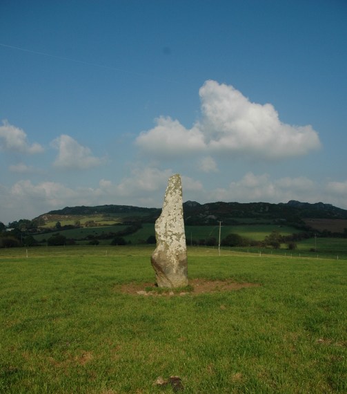
What seems to be a very common type of standing stone around here, it’s about one and a half metres tall, very square from its base to almost its top where it seems to have been broken.
There are 6 barrows marked on the map just west of Killucan. They range across 4 townlands: Sarsfieldstown, Rathwire Upper, Lisnabin and Rathnarrow. The large one depicted here is just over the fence beside the R156 in Sarsfieldstown. It’s the biggest barrow I’ve ever seen, flat-topped, about 45 metres long, 10 metres across and rises to about 2 metres. Erosion from cattle grazing has exposed some of the mound. From its top you can clearly see the much smaller barrow in Rathwire Upper about 400 metres to the north-north-east.
The other four barrows are not visible from here, 3 on a spur between 2 hillocks in Lisnabin and Newdown at Rathnarrow and 1 on the peak of Lisnabin itself.


16/9/07
Greenan Barrow, 12 metres or so in diameter and about 2 metres high

16/9/07
Standing stone roughly 1.4 metres tall
Recorded by Liam Price on 18 March, 1932, “’The Druid’s Stone’ lies on the edge of the ‘street’. It is covered on one side with cup-markings, an inch deep, some rather less, of different sizes. The largest is 5 inches across.”
Price’s sketch shows a stone 29 inches wide by about 2 feet tall with 20 cup-marks. I visited Threewells today, 14/9/07 and couldn’t locate the stone. The area where I believe it once stood is totally overgrown.
This was a long, arduous trek, began at Raheenakit and along the Wicklow Way. The forest tracks are fine, but the last 80 metres ascent through the heather, gorse and tumbledown mess nearly did me in.
The cairn is being reclaimed by mother nature, with it’s lower sections covered in peat. It’s very roughly 20 metres in diameter with cairn rubble showing in a few places at its top.
The gorgeous views on a sunny mid-September evening made the trek worthwhile: south-west to the Blackstairs, north to Keadeen and Lybagh, and south-east into Wexford. I could see the sea off Gorey. Directly west you can see forever.
I was able to pick out the wedge tomb at Moylisha to the south-east. Descending down through the ruined pine plantation I went arse over tit and nearly broke me wrist.


If there is a standing stone here it’s buried deep in impenetrable pine woods.
A stone may have once stood on Cullentragh mountain, but alas no more. There were one or two candidates for the former standing stone but I could scarcely be bothered after the hike and the disappointment. In fact, I’m really very doubtful that there ever was a standing stone here. However, the views up here are stunning.
25/8/07
Leitrim bullan rests flush with the ground at the back of the cemetery, lost and ignored. There’s two massive army caterpillar diggers parked up about 200 metres away. These have been in action near the stone and you can see the track impressions on the stone. So, it’s only a small, single basin bullaun, less than a metre square. It’s probably not that important in the bigger scheme of things – who cares?


