

The two massive portals at the front of this classic wedge tomb


The ruined cashel, looking over Colgagh Lough towards Knocknarea.

From the back of the two eastern galleries. Knocknarea is now visible from the site.


The gravity-defying lintel with Knocknarea off to the left

The massive tomb from the back of the western gallery

Knocknarea, sacred hill, looms large over Sligo town, Saturday evening, 1/11/08


Looking east along the chamber/gallery. The small hillock that the tomb is on falls dramatically away at the tree-line in the distance.


A poor shot of the larger, better preserved (south-east) circle. The only way to photograph this place properly would be from a helicopter!


The 4 remaining stones of the circle (with fógra) and Slieve Glah in the background.

The standing stone at Moher. The hill behind contains the Banagher prehistoric complex with a henge, 2 stone circles (one with the remains of a passage grave at its centre) and some barrows.


Looking across the henge towards the larger (south-east) circle with its passage grave mound.


The easier approach to the stones is along the track from this sign
“A scealp is a cleft or chasm; the word is much used among the English-speaking peasantry of the south, who call a piece of anything cut off by a knife or hatchet, a skelp.”
The Origin and History of Irish Name of Places P.W. Joyce
There’s a track marked on the map that runs north from the road that skirts the south of Slievecorragh. I headed along here past the 1st old farm building until I reached the 2nd ruined farmstead. The bullaun is in the marshy field to the west of this. I spent about 20 minutes scouring this field in increasing frustration and headed down to the rath for a look.
The rath is fascinating, with the deepest fosse I’ve yet seen on one of these. It’s easy to explore at this time of year but would be impossible in the summer months. The inventory says that there’s no sign of an entrance, but they visited in August and I saw a clear entrance in the north-east quadrant.
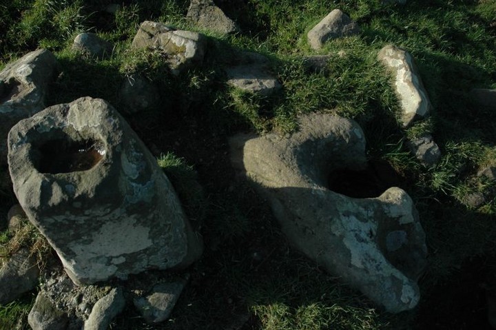
Heading back into the bullaun field I noticed a cluster of boulders beside a massive gorse bush. The bullaun is here, almost flush with the ground. It’s a little over a metre squared and the basin is one of the smallest I’ve seen, placed centrally in the stone. The sides are sheer, carved directly down into the flat-topped boulder to a depth of about 15 cms.


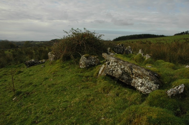
One of the best preserved of these I’ve seen. Pity it’s so overgrown.


My fifth visit to this site and the first time there hasn’t been livestock in the field, so giving me a bit of time here.
Site L, the one nearer the main mound, is almost totally destroyed. Four stones remain, a kerbstone and 3 chamber orthostats. None of the passage is remaining, or could it be that it is buried?
Site K is more interesting. Much of the passage is here. There seems to be a sillstone or doorstone at the mouth of the passage. Some of the passage orthostats are collapsed in on their opposite stones. Overall length is approx 15 metres, with a slight widening about midway along. It terminates in an undifferentiated chamber, the backstone of which is missing. The kerb is best preserved on the north-western arc, but there are some stones to the north. One puzzling factor is that an imagined continuation of the kerb arc would not meet the mouth of the passage but hit the 3rd or 4th stone along. Don’t really know if this is significant.
The hillock that both tombs sit on is higher that any of the surrounding terrain, including the ground level of the main mound at Newgrange. Trees and shrubs block this feature when viewed from the road in front of Newgrange. Looking north-west, the main mound at Knowth can be seen in the distance.
It was very windy here today and my hands were freezing as I took photos. It would be lovely to sit here on a sunny summer’s day, drinking in the atmosphere. It’s hard to say what sense of place you get here, knowing that big brother is only yards away. None of the previously mentioned decorated stones were visible, though some of the passage stones seem to have very worn and vague pick-marks.


Very scant remains of Site L, one kerbstone and 3 chamber orthostats.

The hillock that K & L are on is higher than the ground level of the main mound at Newgrange. This would make it the highest natural point in the Newgrange area.

Looking north-west over the passage and down the hill across the plain towards Knowth. You can see the mound at Knowth in the distance.


Nobberbeg townland, next (unfortunately) to Muff townland, is at the back of Gallow’s Hill, north-west of Nobber (An Obair) town in north Meath. On the old OS maps at archaeology.ie this site is marked as St. Patrick’s stone. The site sits at the edge of a ridge that falls away to its south.
There is an old cross base here, beside which sits this interesting bullaun. It’s one of those kneeling bullauns, both basins of which break the side of the stone. One holds water in its bottom, the other unable to do so. On the map mentioned above there is a second bullaun marked. I think I saw this too but it’s been smashed up, much like this unkempt and uncared for site.
This is well worth checking out, if only because there are many different sites of archaeological interest in close proximity.
I came here with the bullaun in mind, having seen it on archaeology.ie. It’s about a metre and a half long by half a metre wide and has one shallow basin. It’s now cemented into the side of a shrine to St. Brigid which in turn sits beside a dry holy well.
I had a delightful companion during my time here – a gorgeous little puppy that followed me down from the house where I attempted to ask for permission to visit the well.