


Fairy Well main part – wellspring issues from base but are these stones in place or have they fallen into the well ?
Finally found Fairy Well at HY2943212982. The Ring of Brodgar and knowes are in a large field with a quarry and such at the SW corner. From this corner a short fence forming a Y with it goes towards the loch and 5m from the base of the Y the well is well hidden by undergrowth at the edge of the steep bank here (about a fence post height). Scramble down onto the shore and look back at the ‘cliff’ face, watching your step as the ground is lumps and bumps and very squishy [so you don’t notice your feet sinking in]. All the way up are large stones of varying shapes though at the moment the spring comes from a gap at the base. A man came walking his dog which lapped up the fresh water momentarily revealed. Not a very regular construction and it appears to have collapsed back – a few feet to the east several yards of the bank have been roughly faced with very large slabs etc. to hold the bank up. Removed as much veg as I could, not sure how it would stand wholesale removal in its present state.
Pococke 1760
“[from the Ring of Brodgar] There is a single pillar about 50 yards to the North East, and a barrow to the North and South, one to the South West and another to the North East...
another circle of stones [Stones of Stenness] which are 15 feet high, 6 feet broad, the circle is about 30 yards in diameter, and the stones are about 8 yards apart. There are two standing to the South, one is wanting, and there are two stones standing, a third lying down, then three are wanting, there being a space of 27 yards so that there were eight in all : Eighteen yards South East from the circle is a single stone, and 124 yards to the East of that is another [Odin Stone] with a hole in one side towards the bottom, from which going to the circle is another [stone] 73 yards from the fossee [sic], the outer part of which fossee is 16 yards from the circle : there are several small barrows chiefly to the East [Clovy Knowes].” His map shows a large squat stone close to the shore E of the S end of the bridge – this and the possible causeway perhaps a reminder of when the main road went along the driveway to Stenness Kirk.
Low ~1774 unpublished ms “History of the Orkneys” quoted in 1879 edition published by William Peace [referring to a lost drawing, that published being one by William Aberdeen from the1760’s]
“[Stones of Stenness] The drawing shows the stones in their present state, which is four entire and one broken [??recumbent]. It is not ditched about like ... [Ring of Brodgar]..but surrounded with a raised mound partly raised on the live earth, as the other was cut from it... near the circle are several stones set on end without any regular order, or several of them so much broken, hinder us as to the design of them.”
William Aberdeen’s annotated map [donated to Royal Society of London 1784] is the source of observations attributed later to Hibbert
“When Oliver Cromwell’s men were in this county they dug tolerably deep in the top [of Maeshowe] , but found nothing but earth” also that site used for archery + “[E of Ring of Brodgar] a small mount... still retains the name of Watch Hill or Tower [Plumcake Mound rather than Fresh Knowe I think].”
The Dyke o’Sean, aka the Dyke of Seean ‘line’ [i.e. boundary dyke] RCAHMS NMRS record no. HY21SE 68 presently runs from HY28901367 to HY29431362 (across the parish boundary as it now is) but formerly ran from loch to loch with the Loch of Stenness end “built on each side” , with a cart once being with difficulty extracted therefrom. Close by the dyke’s north side is the Wasbister Disc Barrow and to its east a mound now not classified as burnt, then a whole settlement. The paucity of sites between it and the Ring of Brodgar complex would appear to indicate a prehistoric date, especially seeing how busy that landscape is N of the dyke. The nearest found by geophsics are two possible ring ditches HY21SE 93 somewhere in the field to the south’s southern half. At some remove, near the complex at HY29051322, by Stenness loch is an L-shaped cropmark some 55m long and ending at the shoreline. RCAHMS NMRS record no. HY21SE 89 is seen as a drain and/or enclosure but may be compared to a feature (HY465131) in the Carness Brecks below Blackhall.
From below Easter Voy followed the loch edge around The Ness. Voy simply means Voy means bay or inlet. There are two of these sites ; site 1 is RCAHMS NMRS record no. HY21SE 85 at HY27071511 then slightly further away a likely burnt mound site 2 is HY21SE 86 at HY26091490. Somehow I failed to see the ever-visible causeway linking the former to the land, probably that short distance walking the field edge rather than the shoreline deprived me of this or its more visible from the islet than the shore. From a Romantic perspective site 2 is the more interesting site, with large stones on the top giving a jaggedly profile and that fine section of wall exposed in the western side.
Near the main road is another burnt mound, HY21SE 26 at HY25351497, in the last open space on the south side of the Lyking road. Its being so close to the mill and its dam I can’t help imagining this too was once an islet in the loch like the islet at Redland to the south. In the north side are a couple of very obvious stone blocks. Too nacked by now to go in for a look. The record is for two mounds. That at the back is reckoned natural but it strikes me that what with the disparity between their sizes these could have formerly been one, with the ‘cist slab’ from the highest point being its centre too. The derelict building on the burn’s other bank is Voy Mill itself. On this side further along tis a small scatter of middling stones unlike the usual result of wall collapse and these could have been taken from the burnt mound and removed here after the rest received use elsewhere.
In order to enlarge a field by the Bridge of Brodgar a large amount of a tumulus had to be removed as it impinged upon the corner. The labourers had cut a section 3-4’ deep and thrown the earth removed up onto the mound. Amongst the discard they found what is described as a sinker. Description of ‘sinker’ is an incised water-worn sandstone 7 1/2 inches long, a tapered oblong with a groove around the side. One side quartered to contain sadly degraded images, other decorated with two fishes and a probable seal. Yep, it’s that stone. No wonder this site had been ascribed to a [Pictish] broch. Some years before an arrow-head and a scraper, both of flint, had been found in the mound. (P.S.A.S. XXII [1887-8] article by James Noble).
The mound appears to have been dug even earlier as Thomas’ map of 1851 has some detail of the structure [not apparent on reproductions] including an entrance passage along the side facing the road. Cut was made near back of tumulus. Now I have had a photocopy fom the library and using an Agfa lupe my passage runs along the N side of the east lobe of a kidney shape occupying the S side of the ?top. Opposite the west lobe is a circle and then a curve runs arond the remaining [north-eastern quadrant], possibly joining the outside line of the ‘kidney’.
On my images of HY21SE 9 & 24 eastern=downhill, southern=Brodgar etc.
The greener grass looks to show where excavations have taken place (or on level bits ground disturbed by walking I suppose).


SE9 i exposure near northern end of eastern slope, tape out to 1m

SE9 i northern side, Ness of Brodgar top left & tomb hidden by mound


SE9 ii exposure downhill eastern slope at southern end, tape out to 1m

SE9 ii exposure downhill eastern slope near northern end, tape out to 1m


SE9 ii bank and ditch at top of northern end seen from eastern slope downhill

SE9 ii bank and ditch at top of northern end [or one mound upon another, or ?revetment] seen from SE 24 just east from it


along exposure of SE 24 with tape to 1m – looks cut in this view, hopefully if so test cut not detectorists

SE 24 (top of image) from top of western side of SE9 ii (bottom half of image) with narrow track between

SE 24 northern end with SE9 i behind left and tomb behind that


Gate to field containing Bookan Tomb nicely open. Top of this bare now, no plastic. Gate directly right of track is also open and leads into field with the “eminence thrown up by the brecks” [look at the photos and you really cannot see them as other than a tight grouping] – brecks as land of naturally broken appearance rather than brecks as rough land brought into cultivation. The ground is rather damp near the gate as the farmer is drying a hummock of black stuff off. The quarry is in the brecks but I don’t believe The Brecks are all quarry as a walk around shows a proper quarry fenced off from them at a neck N of the mounds and the rest is too curvy.
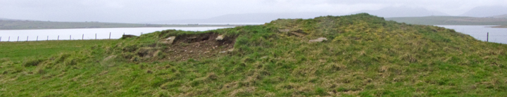
All the mounds have exposed areas, with HY21SE 24 by the edge of The Brecks undoubtedly the most natural, sitting as it does on the natural rock with its single southern exposure capable of being read as proof either way. There is a steepish drop behind its western end and good rocky outcrops in the cliff-face (though a bit ragged for building methinks). Below its NW’ern end down almost into the brecks are one or two slight oval troughs that might have held something or slipped down from above. Almost under the SW’ern end there is a single rock slab sticking out of the cliff-face, which though almost undoubtedly natural has had an earthfast orthostat set at right angles abutting it as if to hold this back. Just the one orthostat, but definitely not natural.
Sites HY21SE 9 i (nearer to the tomb) & ii (to the N of i) are built partly onto the hillslope and each have several exposed areas, some earth with a few small stones and others with proper rocks. Almost certainly ii is the source of the cist. And not just because it has more structural material about and on it. Calling the feature on its top a circular depression is wholly inadequate. Walk below the eastern flank and look up at the northern end and there is a well-defined near hemisherical bank forming the top edge – despite the excavation definitely an archaeological feature rather than from archaeologist’s workings.


top of western side of mound with stones outside mound

southern side of mound and stones outwith [but not from downhill]


