

mark on stone iii definitely not made by any JCB or suchlike
site index
stone pic and a few details
It has been asserted that there are further levels of the broch unexcavated but six foot is all that was found. This is not a greenfield site. Beneath the floor they found clay, vitrified sand and Neolithic potsherds (Grooved Ware and rough Rinyo-Clacton), and the Royal Commision found similar pottery in the kitchen midden [Grooved Ware has been found at Evie Sands by the Broch of Gurness]. Somewhere back on a hill south of the Toab road the descriptio of a tumulus, HY50NW 9, excavated by George Petrie in March 1850 (a 2m cutting from the east edge to the centre) gives us an idea of what likely preceded the broch. This conical barrow stood five feet high and thirty feet across inside a three foot wide shallow ditch. A ring of large burnt stones ran about the periphery of this clay mound. Halfway in the clay darkened and hardened. In the centre Petrie found a “considerable heap” of burnt bones and charcoal bits embedded in the clay in a three inch thick layer. He found no stones there and no tools in the barrow. Perhaps the five vanished Howies of Bossack (at the quarry that is now a tip) were similar. Petrie also dug one of the low flat-topped mounds a few feet away and found a NNE/SSW short cist containing earth and clay with some burnt bone at the bottom, with a celt deposited outside the NNE end. Could this be the nature of the presumed dwellings between Dingishow and the Deerness shore – they have been dismissed as the results of sand quarrying but the 1798 Statistical Account specifically refers to them as “hillocks of stones”.
Interior 3D panorama
Sigurd’s page updated with links to 2011 plan and two 3D panoramas

tower mound from cliff edge gives impression of height

tower mound and ? outer wall mound

tower mound on north side of kirk


tower mound outer turned to cemetery, with stones from previous use at edge and base

from east kirkyard wall over to near edge of main mound

looking along east wall with profile of tower mound periphery

top of tower mound running under east wall

broch mound from burn to the east
Coming from South Ronaldsay after the 4th Churchill Barrier where the A961 turns sharp left to Burray village instead take a right turn onto the Ness road, signposted for the cemetery. Upon reaching Leith the cemetery road goes down directly by Leith’s east side. I had thought to look for any remains that might have survived from the earlier church, but as I passed along to the shore it became obvious that before the Viking estate a broch had stood here. No reference exists to one here, but my fellow Brochaholic Dave said he always thought there should be many more in these South Isles than hitherto suspected. Perhaps this is because despite the monumentality of the mound/s there is a distinct lack of stonework (hopefully because still covered over), though when you think many stones must have been removed before kirk was built the landowners have kept it rather well preserved. It has elements reminding me of three other chapel brochs; the old Holm parish church and Warebeth in Stromness and Overbrough in Harray. The roofless church sits on top of the broch tower mound and the majority of the outer settlement looks to be between it and the nearby burn [to my eyes that is]. For the most part the broch surrounds the kirkyard on the north and west over to the path to the shore. The 17thC church appears to be towards the edge of the tower, either because the old kirkyard has gone or because an early chapel was attached to a Norse hall. It sits in ground above the rest of the kirkyard as there is a two foot deep rectangular cut through the mound. The old wall at the east end looks deeper and a little different in character also.
And the church is worth a visit for itself !
The NMRS record for the site describes the present roofless kirk, which was built in 1621 at about the same time as the nearby Bow of Burray was rebuilt. St. Lawrence was patron saint of both Burray and South Ronaldsay, ecclesiastically the two were governed from Burray. According to the chairman of the Bu Sands planning commitee the original church was on the site of a Viking estate. The South Isles coastal survey had to miss out this area, though the principal broch profiles are readily observable without entering the field behind the kirk – my friend David Lynn, a broch expert, having seen some of my images agrees with my assessment (full confirmation pending some future visit alongside known suspects Kyelittle and Hillock of Fea).


main mound area from furthest visible from Ness of Campston road


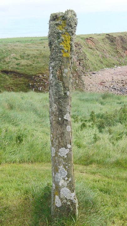

Taking the road to Deerness, after the St.Andrew’s School junction you come to the Stembister junction in the Upper Sanday district. This road you then follow all the way to the Stembister millstream. Once over this you should find a place to park your vehicle before going on to the farm. Be careful not to disturb the ducks and geese as you pass through farmyard. The stone is on the northern end of the wifey’s drying green a short distance in front of the house.
RCAHMS NMRS record no. HY50SW 6 is a N-S aligned stone standing 6’2” high and varying in width from 14½-28”. In about 1965 the stone was moved from a rapidly eroding clifftop a few metres inland to its present position (the small packing stones were removed between 1929 and 1964, presumably whilst moving the stone).

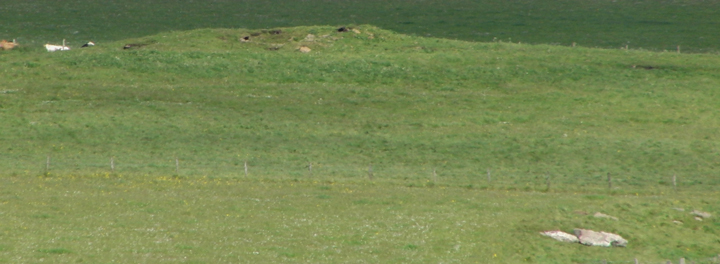
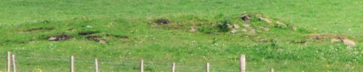
This can easily be seen on the northern half of the Loch of Swannay side of Costa Hill when coming up from Evie, a mound with two layers of vegetation. However even when you know where it is it is a far harder spot from the road below, as the photo shows. My theory to explain this is that the barrow has a ditch and a [?low] bank, and that these survive best above and below as a person coming up or down a hill would avoid such big bumps along the way. Unfortunately being on my way to Birsay I did not go up and investigate. The hardy may choose to climb the wearyall to the viewpoint on top of the hill, where amongst the WWII radio station remains you can see for vast distances across Mainland and over to several of the other Orkney Isles.
RCAHMS NMRS record no. is a 16.7 by 15.2m heather-grown bowl barrow on uncultivated land. An excellent spot by Jane Downes.
Accordiang to “Grampian Battlefields” some believe that it is this which is the actual Craibstane rather than the massive square boulder near the junction of Harfgate and Bon Accord Terrace (the crest of Clay Hill). In which case it was probably a march stone for Rubislaw.
According to “Grampian Battlefields” the Liggar’s Stone before removal to Mains of Inveramsay as a gatepost stood near Harlaw House, which would place it in mediaeval Harlaw – an unlikely place for a stone circle.
“the stone circle of Randra... formed of a lot of upright slabs of stone with the altar placed in the centre, the ground all round mixed with vitrified cramps locally called smithow cramps” 1903


This time young kie present so kept out to avoid the curious creatures trampling the evidence as they followed (as is their wont)
