Model of Wayland Smiths Cave (i.e. pre restoration). 3 miles from Shrivenham Station (Berkshire).
wysefool
A wooden replica of Wayland’s Smithy.
Wayland’s Smithy Restoration in the 1960s. Richard Atkinson and Stuart Piggott.

An early photograph of Wayland Smith’s Cave. Of note is the lack of beech trees surrounding the monument.
Image credit: Wilsons Almanac

Harold Burnham and Beatrice Blackwood standing in front of Wayland’s Smithy.
Image credit: Pitt Rivers Museum
youtube.com/watch?v=xh1DES4zmjg
Video of GPS scale model of White Horse Hill being constructed.
PDF file containing plan diagrams and textual info from digs. M Avery, 1982?
An Early Iron Age settlement site covering 1000 sq m
Excavated in the 1980’s with usual pottery, bone and some flint finds.
showing the old flint mines at the top edge of the Devils Punchbowl.
‘There is an unusual concentration in the village of sarsen stones, including a ring of twelve which form the foundations on which the towers of both the present church and of its medieval predecessor were built, and two close to the wooden bridge over the river at Berry Lane. According to local folklore, the twelve stones originally stood as an upright circle on a mound near the site of the church. A Charter granted in the year 972 AD, in the reign of King Edgar, refers to an ‘Egsanmor’ (slaughter stone) at Twyford. It is from bits of evidence such as these that the legend evolved of a Druidic religious site having existed in the village in pre-Roman times – perfectly plausible, given the proximity of Bronze Age (ca 1500 BC) and Iron Age (ca 1 AD) settlements on the hill later named after St Catherine and on Twyford Down.‘
Information on Dragon Hill, including:
In a 10th century charter, the hill is given its original name of Eccles Beorh, that is ‘Church Barrow’. This may suggest that a Christian religious building once stood on the summit.
There was a geophysical survey conducted in 1990 to identify the early medieval chapel that once stood on dragon hill.
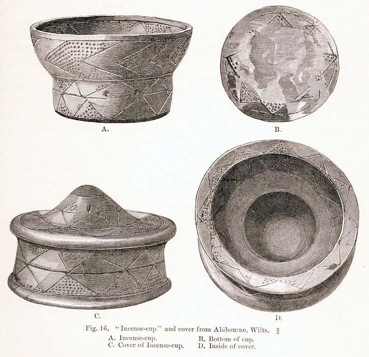
nice piccy of the aldbourne cup found in the barrows.
also
stone-circles.org.uk/stone/images/incense%20cup2.jpg
another piccy of the cup
Aldbourne Four Barrows. – Sugar hill, Aldbourne near Hungerford.
Bronze age barrow cemetary 2500 – 1500 BC.
The contents of these Barrows are now in the British Museum. Three of the four barrows are of the Wessex bell type of barrow these are eight to ten feet high. The fourth is an ordinary bowl shaped mound, also ten feet high. They were excavated by W. Greenwell near the end of the 19th century. Two of the bell barrows contained cremations and the third a skeleton. Other finds included amber, beads, flint arrowheads, fragments of greenstone axe and a grooved dagger. The bowl barrow had a cremation in a burial cist covered with four sarsen stones. The famous Aldbourne barrow is at the foot of this hill in the field by the A419 just north of the wood. It is a bowl about 100 feet across by six feet high. The mound provided the British Museum with its Aldbourne cup, an incense cup with lid, and two bronze awls, a bronze dagger and beads of faience, amber, fossils and shale.
from:
Photographs of the Aldbourne blowing stone, from Liminae.
good information site about events at Sinodun. Loads of information for family days out.

QTVR of on top and inside the barrow.
scheduled monument record +a few relevant links

‘Shadow Tracks on Wayland Smithy‘
There’s a few more Waylands artworks at suefawthrop.me.uk/
Image credit: Sue Fawthrop
from David Nash Ford’s ‘Royal Berkshire History’ website. Article on the dating of the white horse with many pictures.

Cover of English Settlement by XTC. The Swindon connection!
Image credit: XTC
During 1981 and 1982 an area of the East ditch was dug. Radiocarbon dates from material from the lower levels of the ditch indicated a date of 2900BC.
Mesolithic remains were also found.
‘E T Leeds investigated Neolithic, Bronze Age and Anglo-Saxon sites near the cursus on the second terrace, and the Abingdon Society has excavated a Neolithic henge and bronze age remains to the north of the Cursus.‘
from ‘Excavations on the Cursus at Drayton, Oxon‘
R Ainslie & J Wallis, Oxoniensia LII
Artist pencil drawing and information including:
Chun is derived from the Cornish ‘chy-an-woone’, meaning house on the downs.


Lowbury Hill: An artificial grove?
‘Lowbury Hill in Oxfordshire, England, has long been regarded as the site of a probable Romano-British temple. The summit of the hill is occupied by several earthworks, including a rectangular enclosure and a round barrow. The site was excavated in 1913-14, when the bank and interior were investigated.
Further work has recently been carried out, including a geophysical survey and a limited excavation programme. One of the most interesting features discovered in this new investigation is the presence of a series of shallow, irregular scoops in the chalk, filled with dark, loamy soil, which have been interpreted as tree holes. These seem to have formed part of the primary demarcation of the sacred enclosure, and appear to represent deliberately planted trees.
This activity perhaps took place in the first century AD. The inference is that the first construction was replaced in the second century AD by an enclosing wall: inside there was probably a simple temple building; associated with it were a group of spears (including a deliberately bent one), coins and other finds indicative of sacred use.
But the first phase may have comprised a deliberately planted holy grove. One further discovery of possible relevance is the burial of a woman whose face had been mutilated, though it is uncertain to which phase this body belongs.‘
Miranda J Green
1997

Detail of the Sarsen at West Kennet, the one that is often wet (is it over a spring?) Taken 2003
Image credit: Wysefool
BBC News – British Library books go digital
‘More than 100,000 old books previously unavailable to the public will go online thanks to a mass digitisation programme at the British Library.
The programme focuses on 19th Century books, many of which are unknown as few were reprinted after first editions.‘
Should be interesting for us TMA’ers ;-)


Found this worked flint in a bunny heap at Perborough. If any flint specialists can shed any light, I would be grateful. Please add a comment if you know what it is. Many Thanks, the Wysefool X
Image credit: Wysefool

The Blowing Stone – the sign on the tree reads:
Contributions to the blowing stone fund will be gratefully recieved by the local custodian. The proceeds are devoted to local charities.
(soz, can’t read the name underneath)
Image credit: F Frith & Co

Copper1: We’ve had reports of hippies smoking drugs Sarge.
Copper2: Based on what information constable?
Copper1: Apparently there’s a ‘stoned circle’ somewhere around here.
Copper2: Ur, how many ‘O’ levels have you got constable?
Copper1: One. sir.
Copper2: What a coincidence, me too!
Image credit: Mike Wells

No wonder the RAF (or possibly the Royal Flying Corps?) once wanted it knocked down, the rate of climb for an aircraft like that must be p**s poor!
O Biggles where for art thou :-)
Image credit: J Welch & Sons
The morning looked bright and clear, and so a quick visit to this barrow (i only live minutes away) seemed an easy option to grab some photographs.
The barrow is located above the Devil’s Punchbowl and not far from the Ridgeway itself. I parked where the Ridgeway crosses the Lambourn Road, and where the Model Aeroplane Club have their site.
By the time I got half way across the field, I realised that I wasn’t dressed up enough to cope with the icy wind which blasted away and nearly took me hat with it a couple of times.
This was a nice reminder for me of what I always preach to others, which is: always go properly dressed if you’re going up the rudge. It may be pleasant and warm down in the valley, but it’s amazing how a few hundred feet up the chalk, the wind, temperature and weather can be totally different!
Away to my right, and on the distant horizon, I could make out the large hump which has Beacon Hill Hillfort on its crest. The view down into the Vale is outstanding on a clear day, and to my left I could see over to Boars Hill. Ahead, the towers and chimney stack of Didcot Power Station dominate the landscape. Glancing over my shoulder I could make out the denuded barrow of Pigtrough Bottom and wondered if the two graves were related in any way (same period, or possibly even same tribe?).
The lump lies next to the fence and nearly adjacent to a small stile. Once across, I had a close up look. There’s a single Elder bush next to it that seems to be doing quite well, given the exposed location. The usual bunny holes have penetrated the barrow in a few places and were quite deep. A quick rummage around the spoilheap, but no treasure was found!
The grave sits not far from the edge of the punchbowl and I thought about all the times I’ve walked here and never gone the extra few feet to investigate. The Punchbowl is an impressive piece of topography, in a funny kind of way, like the manger below Uffington Castle, although not quite as stunning.
The last time I was in the vicinity was to walk my friends lurcher, Lenny, who sadly passed away (old age) a few years ago, he’d definately of flushed any bunnys out and had a good time!
I took a few snaps (before I lossed all feeling in me paws) and wandered over across the ploughed piece towards the edge of the punchbowl. An object caught my eye on the ground, and I bent down to pick up a coin. Upon closer inspection it turned out to be a half penny of George VI from 1949 in very good nick.
Happy that I’d found treasure (a stone with a hole in it is a valuable treasure to me – i’m easily pleased), I started back to the motor and it was good to finally get out of the wind.
PS When I got home, i looked on Google Earth and you can make out lots of marks on the ground near this site – could those be remains of the workings that J R L Anderson saw when he visited?
Description of the meaning of ‘Hackpen‘

full shape of the barrow from the ploughed field side
Image credit: Wysefool


‘1556 – First recorded by a churchwarden of Abingdon and mentions the establishment of a bower.‘
Reference to Robin Hood’s Bower as being a possible Sacred Grove site related to Cernunnos/Herne mythology.
Maidenhead Thicket, Robin Hood’s Arbour.
‘Mrs M A Cotton has directed excavations during the summer of 1960 on this sub-rectangular earthwork ...but Mrs Cotton obtained sections across the bank, ditch and counter-scarp bank. Outside and inside the entrance was found a cobbled trackway but no definite evidence for any timber structures. A hut or farmstead probably had existed in the enclosure and burnt down, for several isolated pieces of burnt daub were found to show that the enclosure had been constructed by the Belgae, probably between AD 25-50.‘
source: Berkshire Archaeological Journal, Vol 58 1960
‘In 1947 a silver coin of the Dobunni, type of Mack 384a, was found at the hill fort of Uffington Castle...‘
source: Berkshire Archaeological Journal Vol 58 (1960)
The Celtic tribe inhabiting the hill fort was Atrebates. Was this coin traded, or the spoils of war?
Good information on Alfred Williams, lover of Liddington


foto taken 2005, the platform is a relatively new addition
Image credit: Wysefool

artistic view of the Cromlech, love the trees in the background
Image credit: unknown

1-50 of 362 postsNext page