Hob

Hob

All posts expand_more 1,151-1,200 of 1,578 posts

Eel Hill

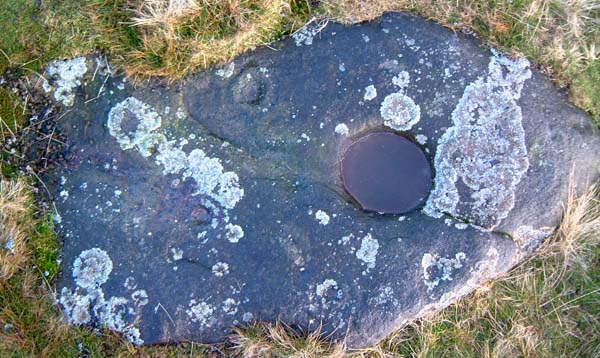
Fitz made a very good choice of stone to seek. The front cover of the indispensable Laurie and Beckensall book has a photo of a glorious stone very similar to this. If I were them I’d have picked this one. It’s a dahza!
I’m stumped as to why the hill is called Eel hill though. Seems a bit peculiar, it’s not near the sea, or any rivers that look like they’d have eels in them.

It’s an especially complex motif for the area, and is also conspicuous in that it is the only one on the summit of the hill, whilst the slope on the way up had oodles of marked stones though none with the such a clear cut bowl. It nicely connects the cairns etc (on the slopes below) to the mysterious atmosphere of Osmond’s Gill . It’s a special stone marking a special place.

Barningham Moor

What an absolutely grand spot! Cup-marked stones all over the place. My eternal thanks go to Fitzcoraldo for showing me this place.

A copy of Beckensall and Laurie’s ‘Prehistoric Rock Art of County Durham, Swaledale and Wensleydale’ is very helpful. The sketched map, cross referenced with the diagrams, means that if you find one, you can find loads. It does appear that there’s a map amiss in the book though. Stones 3-13 are represented on the ‘West and South west’ map, as are stones 19-32. 33-81 are shown on the ‘Barningham- South’ map, but 14-18 aren’t shown. Which is a shame, as from the diagrams in the book, they are some of the more complex in the area, with multiple rings, arcs and pennanulars.

After a nip up to Eel Hill to find the big cup, then to Osmond’s gill and the circle near Howe Tallon, the marked stones of the South side were in shadow, and harder to spot, but the whopping cup of stone 48 decided to reveal itself. The hut circles in this area are quite clear, more so than the enigmatic burnt mounds further down the slope.

It would be a right pain in the neck if the bracken were in full flush, but in the winter, with some nice direct sunlight, the stones are easy to spot at a distance. There are many, many more unmarked than marked though. The shelves with the marked stones, sited as they are either side of the wonderfully atmospheric Osmonds Gill, are extensive markers for what was, and still is a very special place.

Gled Law North

I’m slightly perplexed to say these are the most ‘threshold’ of all of the rock art listed by the Beckensall. They are so heavily eroded, Mrs Hob and I were not sure we’d found the right rock, and searched extensively, but found no others.

As Pebbles says, the big flat rock looks like it is crying out for carvings, but has none. It’s a good marker though, being clearly visible from the top of Dod Law.

In high summer, the ferns and bracken make getting under the gorse bush a bit of a clarty endeavour.

Miscellaneous

Dewley Hill Round Barrow
Barrow / Cairn Cemetery

The following cribbed from English Heritage via Magic Map:

“Bowl barrow situated 350m NE of Dewley Farm near Throckley.
On a small rise above Dewley Burn, Circular in plan, dome shaped in section. 6m high, 40m diameter with associated cropmarks. Neolithic stone axe found at the site.”

This is backed up by local affirmation that ‘it’s always been a burial mound’, and farmers having found flint artefacts in the vicinity.
Despite this apparent provenance, there are some academic references which seem to imply doubt, arguing that this is a natural feature of the landscape. It seems a bit unlikely to my uneducated eye, as there are no other hillocks like this. None so round, nor any with the neolithic artefacts placed so that aximum visibility is from a nearby spring. It’s a burial mound. Surely.

Dewley Hill Round Barrow

This autumn’s ploughing doesn’t seem to have gone any further in. The badgers are still there. The outline of the mound was clearer without the foliage.

However I was quite taken with the large pool which had expanded quite a bit since my last visit. Something about the association between pools and ancient votive practises. It’s probably a pithead from a 20thC mine or something, but hey, idle speculation is fun.

Miscellaneous

HareHaugh Hillfort
Hillfort

A neolithic long cairn has recently been identified a few hundred metres to the south of the hillfort. This cairn may have played a role in the decision to place the stones of the nearby Five Kings alignment in their position overlooking Hareheugh hill.

Miscellaneous

Salter’s Nick
Ancient Village / Settlement / Misc. Earthwork

A mesolithic rock shelter has been found in one of the overhangs on Shaftore Crags, to the NW of the IA/BA settlement.

This fits a vague pattern for this area, usually there is associated rock art, which in this case there is, at Hallion’s rock. I’ve a gut feeling that there would have been a lot more rock art on the crags before they were quarried in the late 18th century. There are a few recorded ‘portables’ in nearby farms, though perhaps these were once part of the crags. The stone quarried from the crags was used to build almost all of the farms and walls on the Shaftoe estate.

Miscellaneous

Borrowston Rig
Stone Circle

8Digit ref: NT 5576 5231
Info from RCAHMS:

“The setting of these stones is an example of Thom’s Type II egg-shape, though the ten surviving upright stones are inconspicious, some barely showing above the heather. Many more fallen ones are visible and some buried examples were located by probing. Most of the stones lie on a true circle 41.5m in diameter. The west segment is formed of an arc of a circle 25.6m in the diameter, the circumference of which passes through the centre of the main circle. The perimeter is completed by straight lines which join the arcs of the two circles.”

“A plain circle 41.5 by 36.6m on WNW-ESE axis. Of its low stones, none more than 0.6m high, one lies exactly at the N, 3.1m inside the circumference, like an inlier at Cairnpapple. Thirty-seven metres NW, two stones may mark an alignment on Capella.”

“Situated on level, though boggy ground in an otherwise undulating area, this egg-shaped circle is generally described except that its overall stone-centre dimensions are 48.0m WNW-ESE by 41.0m transversely. Of thirty stones found, five by probing, fourteen appear in-situ uprights up to 0.5m high, and the remainder are recumbent. The SE arc crosses an overgrown and boggy area where further stones are probably buried. The alleged inlier on the N side is an inconspicuous flat stone, and no significant stones were noted to the NW of the circle.”

Miscellaneous

Cauldside Burn
Stone Circle

According to RCAHMS:

“This peat-covered stone circle is situated in the saddle between Cambret Hill and Cairnharrow, and it lies immediately to the SSE of a large round cairn (NX55NW 22). Nine stones survive on the N and W arcs of the circle but only two others are visible on the remainder of the circumference; together, they define a circle about 25m in diameter. The largest surviving stone, which lies on the WSW, stands to a height of 1.2m and measures 0.8m by 0.2m at the base. The stones are all thin slabs, with their broad faces aligned on the circumference of the circle.
What may be an outlier to the circle lies some 100m to the NNE (NX 5298 5723); it comprises a flat slab protruding from the peat with its long axis orientated towards the centre of the circle”

Miscellaneous

Old Harestanes
Stone Circle

The following dredged out of RCAHMS:

“This stone circle consists of four large conglomerate boulders, varying from 2’-4’ in height, and a fifth broken off at ground level, arranged on the circumference of a circle 10’ in internal diameter. A sixth stone, 5’ E of the truncated one, has probably been broken off the latter and moved to its present position in recent times. A thin sandstone slab protruding through the turf outside the NE arc of the circle is not earthfast, and is unlikely to have formed part of the monument. No comparable monument exists in Peeblesshire, but one near Penmaenmawr, Caernarvonshire, dateable to the Middle Bronze Age, is strikingly similar.”
(Information from R W Feachem notebook 1955-7, i, 68)

Image of Leacet Circle (Stone Circle) by Hob

Leacet Circle

Stone Circle

Nearly fallen, but looks like it’s been that way for a good while. Long enough to cause a noticeable difference between the weathering on top and that below.

Image credit: IH