Hob

Hob

All posts expand_more 1,201-1,250 of 1,578 posts

Addeyheugh

Slightly taller than it’s compatriot overlooking Rothbury, but only just. It just has to be a boundary marker for the cairnfield. I guess there may be have been more in the area, maybe there still are.

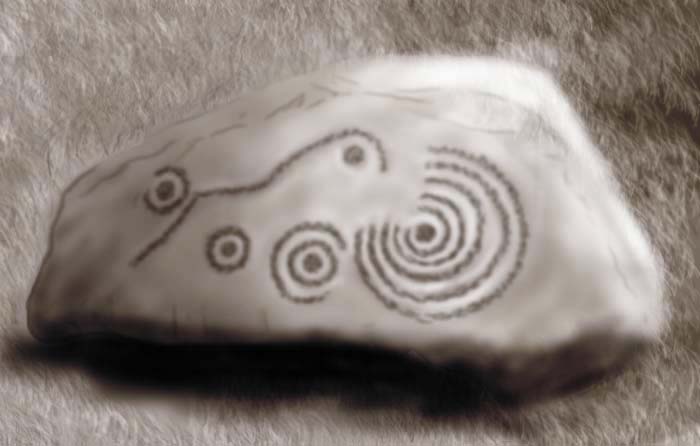
The cup marked rock, about halfway between the track and the standing stone, has a lovely great enhanced natural bowl. Slightly discordant is the name ‘Fiona’ carved large over one of the cups.

A couple of the cairns have survived quite well, and kerbs are almost complete. I’ve a slight problem with the idea that the others are clearance, and not grave markers, as f they are the result of agricultural clearance, it was a very half-hearted affair. The rest of the field is still littered with stones that would make it a bit hard to plough.

There are a few excellent glacial erratics, that if they were in Cumbria would merit the title ‘Thunder Stone’. There’s also a  top-notch natural feature in the form of Ship Crag and the dome of outcrop next to it. Mesolithic rock shelter if ever I saw one.

The ground is quite decent going, low heather, boggy in places, but the track is easily followed. As with much of the area, there are a couple of pine plantations, and in the one to the west, heading towards football cairn, is a stone that would be a good candidate for one of these putative cairnfield markers I mentioned.

Rather unsurprisingly given it’s location, it has a nice view of the nearby sacred hill of Simonside.

It’s probably bikeable, but not very good for wheelchairs due to the many streams that are forded by a single plank.

Five Kings

There are only 4 stones remaining. With plantation on three sides, and Dues hill rising behind them, these stones are almost hidden from the surrounding landscape. Remove the trees, and a superb view of the flanks of Simonside could be had. I’d always assumed that this would indicate some kind of deliberate placing of the stones in relation to Simonside, as so many other sites seem to have this hill as their focus.

But I’m not so sure now. Despite the view to Simonside that would be possible without the pine trees, I couldn’t shake my attention past them, and my mind kept returning to Dues hill. It’s etymological connection with the Duergar, the black dwarves of Simonside’s mythology, and the strange nodules in the bedrock were far more interesting than the over densely planted view blockers. Combined with the possible long mound on Hareheugh hill, and the BA boundary dike and barrows at Holystone, not to mention the cairn circle at Piper Shaws, it all just gets too confusing. There are many other sites potentially connected in some way, but I shan’t belabour the point.
Grouse shooting, ever present wet bracken and driving rain didn’t help the pondering process much either. I gave up looking for traces of the fifth stone.

Still, these are large standing stones for Northumberland. The tallest of the kings tops 2m, and it’s quite remarkable to find four in a line in these parts no matter how tall they are.

If you’re sticking to footpaths (as it’s a good idea to do in shooting season), it’s a couple of miles from the handy parking spot on the Hepple-Holystone road. The path via Dueshill Farm gets quite narrow and slippy at points, and the bracken is a pain in the butt. There are a couple of stiles, so disabled access is not good.

Folklore

Duddo Five Stones
Stone Circle

The narrow waists of the stones, where they meet the soil, have are partly responsible for a pseudonym, ‘The Women’. This, combined with the whistling of the wind through the fluted grooves, has caused this to be extended to ‘The Singing Women’.

Duddo Five Stones

Though little, this is the most aesthetically pleasing of Northumerland’s stone circles. The stones are reminiscent of single stones in the south of the county. It’s position links the Lammermuir hills and the Cheviots most nicely. Weathered grooves second to none, with cups marks too. There have been allegations of a burial in the middle, but nothing conclusive has been found, bar some undated charcoal.

Access up the track is easy enough, but the tromp over the field should ideally be done after the crops have been harvested, both for ease of access, and in respect for the farmer, who has had a poor harvest this year.

Beggarbog

28m diameter, over 3m high. Right next to the ‘so-called housesteads’ car park, on the other side of the road. Unrecorded 18thC excavation has left a great wide ditch running through the middle. It’s been neglected in favour of more recent, rather irritating archaeology.

There are a couple of smaller relatives nearby, situated, as this one is, in the dip between two picturesque lines of crags. This one is right next to a gate off the B-road, so is much easier to find than the others, which don’t get higher than half a metre, and are easily missed when the grass is longer in the summer.

Warden Mound

Possible long barrow. This is contested by some, but asserted by others, who point to the lack of other similar natural features in the area. Claims are also bolstered by alleged traces of stone facing on the SW end of the mound, and the presence of rock art in the locale. Nearby flint scatters add a little bit more credence to these claims, though some of the flints have been attributed to the Mesolithic. I’m not sure of the dates for the cultivation terraces nearby, but they may have more to do with the IA hillfort.

A farmer I spoke to about it said that locals have always believed it to be a burial mound.

Unfortunately for me, I couldn’t get an answer from the house to get permission to wander about their fields, so I gave closer examination a miss for the time being, and settled for peering through the trees from the nearest right of way.

Warden Law

Small-medium hillfort with double ditch and bank structure.
Banks are low, ditches shallow, patches of bedrock protrude.
A number of hut circles are still visible.
Good views of Carr Hill rock art site to the NW, overlooks the confluence of the North and South Tyne to the SW.
Would suit Ottodini tribe looking to protect the upper Tyne from Brigantian incursion.

Ask at Laverick plantation Cottage for permission, as the rights of way which are still marked on some old maps as leading up to the fort from the trees, have been altered.

Poor access, requires climbing stiles.

Homer’s Lane

My attempt in October ‘04 failed to locate this stone. I did find the field clearance boulders; there are a lot of them forming the thorn infested field boundary, which has now been wire-fenced off. The fence has then become overgrown with nettles and some kind of creeping plant that obscures the stones. I managed to check about 30 or forty stones, working from the top of the boundary down the slope, from where here is an old gate next to a big boulder both of which have also been obscured by foliage.

The cup marks may well still be there, but finding them would take a painstaking survey of the hundreds of stones in the clearance strip.

Whilst it would be possible to nip up to the strip of boulders from Homer’s Lane, permission and slightly easier access can be obtained from Thistleriggs Farm.

Miscellaneous

Ninestane Rigg
Stone Circle

In medieval times, the black magician the Evil Lord De Soulis was said to have drilled holes in the shoulder blades of local peasants to assist in the moving of the stones needed to build nearby Hermitage castle. He also kidnapped and imprisoned their children. Robert the Bruce supposedly captured De soulis and the Locals took him to the stone circle to be dispatched. In a vat of molten lead if the tale is true. His ghost, and that of the curiously named Robin Redcap may still occasionally be seen

People have said that there may have once been other monuments and/or settlements in the vicinity:

“On a careful examination of the ground we found that a great extent around the circle (Nine Stones on Nine-stone Rig 35 SW 2) appeared to have been occupied and to the south a number of the same kind of circles had existed but were now entirely destroyed. The hollow in the centre of each circle is still to be seen and the appearance of the herbage and the marks in the earth around clearly indicate the position of the upright stones”.
A Jeffrey 1855

On the top of Nine Stone Rig there is a whole street of circular pits running directly from the stone circle. They are planted at regular distances, and fairly close together, and they gauge from 8 to 10 feet deep, with rather more of diameter. They have in most instances a gently sloping side, in some more marked than others, and runs in a kind of curve towards the north. These, or some of them, may have been originally natural subsidences, although their number, regularity and uniformity of size are against that idea. All the suggestions are that these formed the shelters of the men who set up the Circle and heaped up the barrow... The ground is dry and lying as the pits do, just a little over the edge of the Rig, there would be no danger of flooding”.
J Snadden 1923

But then, more recent accounts dismiss this idea:

“No archaeological significance could be attributed to these ‘pits’ which lie a few metres NNE of the stone circle. They appear to be simply caused by natural subsidences in the mossy ground.”
Visited by OS (JLD) 28 September 1960

Pehaps even more dubious is the report of a possible long barrow (unusual in this area):
“On the western slope (of Ninestone Rig, NY 51 97) and towards the Roughley Burn, I found a long barrow, or earthen burial mound. It is oblong in shape, and the lines of the mound are composed of earth and small stones so firmly compacted together that they cannot be pierced by a spade. The earth has been dug and thrown up from the inside, which leaves the space between the lines hollow. There is a line of mound at each end which meets the main lines at right angles. The length over all is between 80 and 100 yards. The breadth of the base may be eight to nine feet. The barrow is intersected in the centre by a fifth line of mound, which meets the main lines at right angles. The most probable explanation of this is that the barrow was originally square, and was afterwards elongated. Lying on the inside slope of the mound is a stone about three feet in length, in which a deep hole has been cut six to nine inches square. In its place it looks as if it had served some sepulchral purpose”.
J Snadden 1923

Later visitors relate:

“This feature was not located during an extensive perambulation of the area around the stone circle. From the description it is doubtful if this is of any archaeological significance. ”
Visited by OS (JLD) 28 September 1960

Miscellaneous

Buck Stone
Standing Stone / Menhir

Apparently this is a 1m tall wedge, 60cm at its back end, 10cm at the narrow end of the wedge. Aligned NW/SE, pointy end to the SE. Top surface with much weather induced pitting.

Football Cairn

Fairly trashed cairn, as mentioned by Stan Beckensall in his ‘Prehistoric Rock Art in Northumberland’.

In the middle is a cist, the cover of which is rather substantial, and looks like it’s been split in two at some point. The cist is probably the best surviving part of the cairn. It’s main bulk has been spread by excavation in centuries past, and the kerb is visible in patches.

But it’s got the obligatory view of Simonside, added to which is a clear line of sight over the rest of the Cheviots, as far as Kielder to the east, and Cheviot itslef to the north west.

It also has one of the little standing stones with a cup on top, which seem to come as part of the burial package in this area.

It also has a couple of patches of rock art. I couldn’t find the larger of the two, which SB says is the harder to spot. Having found the ‘easy’ one, I’m not surprised. It’s just underneath the ‘p’ in ‘sheepfold’ on the map, and comprises of a large basin and a couple of motifs of cups and concentric rings, covered in lichen.

Access to the cairn itself is by a fairly decent trackway/bridlepath, with a quick scramble over 20m or so of heather, mercifully bracken free.

Revisited 09/05/05

Found Panel 1a with the aid of a gps contraption. It is so weathered. So very, very weathered. I can’t see it being there for much longer. It’s very close to the cairn, much closer than I’d previously thought, just down from the modern carving of a five-pointed star.

Rothbury

What a small, squat standing stone. Less than three feet tall, with weathered grooves on the sides and a big eroded cup on the top. But it has a good view. It stands on a ridge just above Rothbury (the name’s bit of a give away really), and you can see the whole of the profile of Simonside. Rather neatly though, you can’t see Rothbury.

It’s close to the footpath, and if you’re in Rothbury it’s only a couple of minutes walk up the hill. Not much to look at on it’s own, but if you get this far, you’ll be rewarded by the view, and may be tempted to explore the plateau of Debdon cairnfield, or nip around the corner to Football Cairn.

Access isn’t very good, the path from Rothbury has stiles and gets a bit ‘rubble and mudslide’. There is a bridlepath, but the ground is rough, mostly heather and stones, with peaty holes and mini bogs.

Folklore

Five Kings
Stone Row / Alignment

The name has been attributed in recent times as the memory of five brothers who owned adjacent patches of land.

Other explanations, making reference to the inclusion of Denmark in the title, have drawn connections with Morte d’Arthur, where Five Danish Kings apparently do battle with some of the roundtablers.

Miscellaneous

Five Kings
Stone Row / Alignment

In the back end of the 19th century, there were still five stones. The fifth was taken away for gatepost duties. At about the same time, Mr David Dippie Dixon, a local antiquarian, made a sketch which has since been reproduced as a lithograph.

Miscellaneous

Piper Shaws
Stone Circle

Six upright stones, allegedly part of a cairn, according to the ‘keys to the past’ website, which says this information is from unpublished references.

Haughton Common

I could waffle on about this place for hours, but a large part of that waffle would involve the setting of the circle rather than the stones themselves. It’s such a fantastic landscape with the cuestas of the Whin Sill doing their thing.

It’s very like it’s companion at Greenlee Lough in terms of the size of the circle and he stones which comprise it. None are large, but one in particular is an odd ‘L’ shape. The thing that struck me the most was the fact that it’s on a fairly pronounced slope, with the stones at the top being smaller, so that the overall effect is to make the tops of each stone roughly level.

I also entertain a suspicion that both this and Greenlee are some how connected with the highly conspicuous outcrop of Queens Crags, which at Greenlee I’d mistaken as Sewingshiels.

Parking on the military rd can be easily missed, though Sewingshiels is closest, it’s worth the walk from dreary old housesteads so-called fort. This takes you over some great crags and affords very good views of the snazzy landscape.

Either way, access is not easy, though easier from the track heading for Old Stell Green from Sewingshiels. Decent shoes essential, quads being the only wheeled things that are going to get here easily.

Miscellaneous

Leacet Circle
Stone Circle

What the RSM describes as ‘Limited antiquarian investigation’ found a full circle of ten boulders. On the inner side of four of these was found a total of ten urns, many containing cremated bone. The centre of the stone cairn within the circle was found to show traces of a funeral pyre.

Leacet Circle

re-visit midnight 20th/21st October 07
Managed to get down to see these stones at night this time. The yomp down the hill is pretty awkward without any light, as it’s all pine needles, logs and bracken, with a fairly steep slope.

However, it was wonderfully peaceful. Some nice ground hugging mist and an appearance by the half moon made for an excellent atmosphere, but unsurprisingly (if somewhat dissapointingly), no ghostly figures gliding about anywhere. The quarts in the larger of the stones did manage to reflect the moonlight quite well, so it’s easy to dismiss the ghostie tale as a misreporting of similar moonlight/quartz interaction, possibly enhanced by a bit of a more distilled kind of spirit. I dunno. Nice spot either way.


re-visit march 05

About 100m to the SE of the circle, there’s what looks very much like a small barrow, built on top of a small outcrop of lovely red sandstone.

Didn’t manage to get here after dark, so no chance to check out the spooky vibe thing mentioned below. Next time mebbe.


As Stubob says, there’re only 5 stones, but they have some great texture going on. In an area littered with glacial erratics, there are some choice examples in this tattered but determined seeming survivor. I was hoping to be able to see over to Mayburgh, but there’s just too much hill in the way. From the top of the hill, excellent view.

The trees have gone now, so it’s possible to examine the other side of the drystone wall to look for the rest of the circle. It looked to me as if the earthwork below the wall must have some of the circle as grounding stones. About 100m SE there’s a patch of binlinered bales, which hide a couple of big stones, which may be erratics, or may have once had something to do with the circle. I didn’t have time to check at close range.

If you approach from Leacet Cottage Stables, on top of Leacet Hill, there’s a path through the trees that starts badly, doubles back and heads straight for the circle. The last part of this isn’t marked on the map, but then the map says the trees are still there.

The land belongs to Lowther Estates, who can be contacted for permission on weekdays, but note that Lowther don’t work weekends.

Access is not really very good at all.

Miscellaneous

Clifton Standing Stones
Standing Stones

According to the RSM, the smaller southern stone was re-erected in 1977, when a small, plough damaged cairn was found immediately to the east of the stones. In the central area of the cairn there was found a large amount of burnt bone, interpreted as the remains of several humans.

Folklore

Middleton
Standing Stone / Menhir

Of “a field between Lilburn and Middleton, near Morpeth” a tale is told of a stone of “religious significance”, which was not to be moved, on pain of awakening it’s guardian demons.

Two local farm workers decided this was an indicator of buried treasure, and set about the stone with shovels. After a while, they began to think they were wasting their time, and tales of demons guarding the stone must be as false as those of treasure. Whereupon they were spooked by a slight movement beneath their newly dug pit. Despite this ominous sign, their greed encouraged them to keep digging.

Now the earth shuddered, and a monstrous creature, resembling a swan, flapped its wings and flew out of the pit, with a strange and hideous cry. The peasants fled to escape the evil creature, and the stone remains inviolate to this day.

This from ‘Myth and Magic of Northumbria’ (Coquet Editions, SandhillPress Ltd, 1992, ISBN 0 94098 27 1), but there’s a whopping discrepancy. Lilburn is at the other end of Northumberland, near Wooler. Up there there is another Middleton, Middleton Hall, and more or less ‘twixt the two, is the standing stone at Newton Mill themodernantiquarian.com/site/3329.
So maybe this tale relates to the stone near Wooler.

Langdale Axe Factory

It’s been about 10 years, so memory does not serve too well. To be totally honest I don’t think I was at the site of the factory, which isn’t surprising, as at the time I didn’t know it existed. But a couple of things stand out in my mind from wandering about the Langdale Pikes.

If you go the long way from the Old Dungeon Ghyll, up Mickleden Beck, following the Cumbrian Way, there’s a great long linear earthwork thing on the lefthand side, at the bottom of The Band, running up to Green Tongue. It looked a bit heavy duty for such an out of the way spot. No idea how old it might be.

At the very end of the valley, where Mickelden Beck splits to become Little Gill and Stake Gill (NY262074), there’s a sheepfold with a strange lobed footprint. It has a couple of little rooms added to the side. I couldn’t help but wonder if this was the remnants of a prehistoric house. It’s such a wonderfuly remote spot that the ground plan might just have survived, the walls having been re-built maybe hundreds of times after the roof fell in. Pure speculation, but in such a place, I couldn’t help but let me mind wander.

The ODG is an abso-effing-lootly great place to base yourself. Good food, good beer, decent rooms, a giant Jenga set, and even facilities for a small conference.

The Mare and Foal

These two are in an excellent spot, overlooking the Whin Sill at Caw Gap, where it’s possible to get through the crags. It would presumably have been a mian route from north to south in the times before the Wall was built. Good views downover to the Maiden Way.

There are supposed to be underground socket holes, but the site hasn’t been excavated. The immediate area is festooned with nettle patches which could be the signs of these holes. It would have been a small circle, the two stones are 4.5m apart, and look like they would have been on opposite sides of the circle, as they face each other.

There are many small cobbles, which could be anything or nothing, and the third stone, which was standing in the 18thC, is lying a few yards away.

The area has been well and truly trashed throughout the centuries, it’s lucky that these two still stand. Not suitable for those with mobility issues, due to fences, and highly uneven marshy ground, even though it’s close to the road.

Sadly, the burial mound in the nearby field is now gone, only a cropmark remains.

Shap Wells

I’m a little bit out on a limb in designating this place as an ancient mine/quarry (Emphasis on the ‘quarry’, as there don’t seem to be any pits). It’s never been excavated, and was listed as a IA settlement, it’s marked on the OS as a field system.

But on the ground, there is a very visible seam of what I think is metal ore. Soft, shaley stuff with a greenish cast, and many greenish tinged pebbles in the stream. There are very visible remains of structures, in the form of rings and rows of pink granite boulders, The building(?) remains are right next to the stream, and surrounding it are what could well be earthwork banks, protecting the area with the shaley strata.

If these observations are considered in conjunction with the field system, I reckon there’s a case to be made for this having been a mine in prehistory. And I’m sticking with that until I hear otherwise.

The fact that there’s a strange saline well with alleged medicinal properties just adds to the texture of the place. The whopping great Victorian Hotel, complete with attendant octagenarian techo-accordian player, I’m not so sure of. The presence of the hotel has resulted in the covering of the well, which is a bit shan.

The moorland nearby is spooky in the dark, with distant glows of modern pink granite quarries, buzzing overhead cables, faint sounds of the M6 drift in and out of earshot as you move over the ground. Especially if you are lucky enough to catch a blood-red full moon rising over the horizon. I could have done without the midgies though.

Throckley Bank Top

Another ‘portable’ from Beckensall’s Northumbria book, this stone is anything but portable. It’s a boulder measuring approx 1.3 x 0.8 x 0.6m, and can just be tipped over by two blokes.

And tip it over is what you have to do, if you want to see the cups and rings. As the stone has been wisely left upside down to protect it from the ravages of the chavas who inhabit this little patch of trees, doing the things chavas do (few of which are generally compatible with the preservation of ancient rock art).

Bearing in mind that this piece has been moved at least twice, once into the vallum of hadrian’s wall, then from the vallum to it’s present position, I can’t help but think it might be better in the museum of antiquities, like so many of it’s kin. I say this even though I am normally loathe to think of museums as the best place for rock art, it should be allowed to roam free!

It was placed back upside down with the utmost care, and is now fairly indistinguishable from the many other rocks in the vicinity. I think anyone would actually have to be pretty stupid/determined to go to the bother of turning it over, the motifs aren’t even anything particularly special, though the fact they’re in Tyne and Wear, is.

If anyone should wish to have a deeks at this bit of obscure rock art, drop me a line.

NB: A subsequent visit has shown fire damage, in the form of splitting, on unmarked stones only a few yards away. Local piss-heads burning tyres it would seem.

Roughting Linn

The comments below regarding the earthworks made me wonder. The only defensive purpose they could have had would be to protect the decorated outcrop with the rock art. But then this makes little sense when you bear in mind that someone coming down the hill from the east could still just walk right in. So maybe, control of access from the Till valley (highly ritualised neolithic landscape that it is) was the issue. If so, when were they built? Surely not by those who carved the panels? If the earthworks are say, Iron age, then it sort of hints that the big old dome of carved rock had some pretty special significance for a long time after it was carved.

Reminded me of the Pipers Chair down at the other end of the county, which also has a strange rock feature, with artificial carving, and a seemingly out of place set of earthworks.

I’m not even going to try and decribe the cups and rings. Words will not do justice. There just aren’t enough superlatives. Do visit, and find the opening in the fence, rather than scrambling about in the bracken like we did. I don’t think a wheelchair could get here, I recall a kissing gate, but it’s only a few yards from the road so it is quite accessible, as rock art in Northumberland goes.

Dod Law Hillfort rock art

Noticed last week, that the Shepherd’s Cottage, just below the fort and decorated outcrops, is for sale. Bearing in mind that it has no vehicle access, there’s a chance that it will be let out as a holiday place, and would make such a perfect setting for a tour of North Northumberland.

It looks a bit odd seeing a ‘For Sale’ sign on an IA hillfort. It really does look as if someone is flogging the fort, but it’s not included in the deal, nor is the rock art.

Carr Hill

Looking at the motifs in a different light, it seems the uper C&R is placed in such a way that it occupies the middle of a natural ring on the boulder. Stan B often comments on how the existing surface of the rock can determine the placement and execution of the motifs carved upon it.

I’m still a bit baffled by the choice of the valley bottom as a place for the rock art, rather than the usual viewshed outcrops, which abound in the immediate area. However, walking back up to the kennels, A pathway was quite evident (not marked on map, not right of way) that runs east/west. Maybe this has always been a sensible route down to the North Tyne valley, and if so, that might have something to do with the presence of the carving.

The unopenable gate is now openable, but bears a sign ‘Bull in field’, so best ask permission before venturing into the fields. I saw no bulls, but did have an audience of 30 or so cows, arranged neatly in a semi-circle staring at me as I faffed about the marked rock. They seemed quite peaceful (if curious) creatures.

Revisited July 20th 2007


Two motifs of cups, concentric rings and penannulars, quite weathered, but easily discernible. The motifs are in a setting that overlooks a spring, which has now been covered over. The rock art is to be found just to the left of the track from the kennels, after you get past the annoyingly unopenable gate, which is tied with thick nylon rope, meaning access is limited to those who can climb over gates.

Stan ‘the man’ Beckinsall has recorded cups and arcs on the outcrops beneath the overhead powercables. These are amongst many natural cups and grooves, and I’m not totally convinced I found the ones he was talking about. Very much threshold phenomena.

Having said this, I can’t help but think that the natural holes and marks in the sandstone may be part of the reason this place was chosen to be marked with rock art, along with the presence of the nearby spring, and views across to the North Tyne valley.

There are a few lumps and bumps in the ground, but they look similar to marks I’ve come to think of as traces of medeival shielings.

The grid ref here is slightly different from that in Beckinsall’s book, which is a bit of a cheek, especially as I’m seriously fallible in the grid ref dept. But I swear, the earthfast stone with the two concentric c’n’r motifs, is a bit further up the hill. The ref in the book corresponds with a suspiciously prone stone, which whilst having no rock art, has enough bearing to suggest it may once have been a tad more vertical.

I asked for, and got permission from Frankham Fell Kennels, and followed the track from there. Anyone tempted to nip down from the top of Carr Edge, be warned that the going is extremely rough from that direction.