Hob

Hob

All posts expand_more 1,051-1,100 of 1,578 posts

The Cockpit

For some reason I was expecting this one to be smaller, even when it was first spotted fron the top of the hill. I dunno quite why, maybe the landscape around here plays havoc with sense of scale.

The stones ain’t big, but the circle is nicely wide, seems to fit in with the openess of Moor Divock in general. It’s well worth a visit if you’re in the area. It’s easier to approach from the east, from the direction of the Cop Stone, which also gives the opportunity to have a look at a couple of cairns and the stone row.

Access:
Just about do-able with a three-wheeler and determined assistance, not suitable for wheelchairs, paths are rough and strewn with cobbles and ruts. If on a bike, try to have suspension.

Castlerigg

If you ever find yourself despairing of getting this circle to yourself, but can’t get there when there’s no-one else about, try the following:

Put a blanket over your head, get a 1500kW rechargeable lamp, and hop about from stone to stone, whilst trying to angle the lamp in just the right way to find the spiral carving, mutterring ‘No.... Nope, nope, not this one either...’ to yourself as you go.

Apparently, this works. When I put the blanket over my head, there were about 15 people, when I re-emerged, there were just the folk I’d visited with, looking a tad embarrassed.

If you want to actually find the carving, check out Stan Beckensall’s info, or that on the Rock Art in the British Landscape website. I wish I’d done that, then I’d have seen the spiral, but it wouldn’t have been as much fun...

Copt Howe

Caught a glimpse of the boulders on the way to the Old Dungeon Ghyll. I made small ‘eek’ing noises in anticipation.

Then stopped off on the way back, having realised that there is just enough space for a vehicle or two, directly opposite the boulders, but it’s standard Lake District ‘narrow roads with fast cars’, so beware.

The boulders themselves are very nice. The view up to Pike o’Stickle stunning in morning sunlight. It was quite slippy underfoot, and there hadn’t been rain for a couple of days, so if it’s wet, again, beware. There are other cupmarks in the vicinity, but apparently the jury is still out regarding whether they are natural ‘vesicles’ or artificial carvings. Being me, I suspect the latter, I didn’t notice ‘vesicles’ elsewhere, only in the vicinity of Chapel Stile.

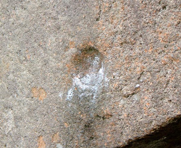
The carvings were quite visible, though being on volcanic stone, they are fainter than is usually the case with motifs on sandstone. But at the same time, they are not so eroded, so the peckmarks are discernable.

What was depressing though, was that there are still people climbing over the carved face.

The issue of climbing caused a minor stir, which the British Mountineering Council claimed was needless, as guidebooks would be altered, and a voluntary, self imposed ban would be enforced by climbers.

Whilst this may well be the case with most climbers, the Fell and Rock Climbing Club of the Lake district for exmple, flag up the existance of the carvings, and point out that English Heritage ask that climbers refrain from climbing in the areas containing the markings.

But the message isn’t getting through to all, or so it would seem. ‘Route 9’, the bouldering route over the face with the main carvings, is still being used, and the evidence of this is there for all to see in the form of chalk residue, used to assist climbers in attempting this ‘problem’ (as it is known in climbing circles).

Furthermore, close examination of the surface of the boulders shows that the cupmarks have been eroded over the years, but only on the lower lip, where one would place one’s feet if one were climbing up that face of the boulder. Now this may have taken ages to happen, but the cumulative effect is there, and it won’t get any the less with the increase in bouldering as a sport. Particularly as the Langdale Boulders are regarded as some of the best bouldering problems in the UK.

It’s unfortunate that this coincides with some of the best prehistoric rock art in the UK, surely there must be some way that both can co-exist without damage to this unique site.

I hope so. This is special rock art. Axe factory rock art. There’s not much of that about is there?

The Cop Stone

It’s a canny old stone this is. It has a strange expression on it’s face. It looks like it’s gracefully drifting across the moor, with a pre-occupied, ‘I can’t stop now, sorry’ sort of vibe.

Having said that, I thought it would be bigger too. Preconditioned by Thunder Stones further down Cumbria I guess.

I was also a bit interested in the other stones poking just up through the turf in the immediate vicinity. You can nearly convince yourself there’s a circle in there if you try. A circle with a shallow pit in the centre, even. Methinks Stubob’s comments are correct, if this was a cairn circle, the kerb is still traceable, and someone’s had a go at the middle.

The path is quite good from the SW, I’d say if you were looking to visit Moor Divock sites, start at this end, not at Pooley Bridge. There were a few cars parked where the road runs out of fence and hedge.

Make sure you’ve suspension if you’re on a bike though, it’s darn bumpy on the behind without it. More than 5 gears wouldn’t go amiss either.

Lower Hobbister

I was sort of compelled to visit, how could I not, given the name connection?

It was late, but there was still enough midsummer sun to make out the parts where the slope is eroding, showing some fairly clear differentiation of soil layers inside the mound. Given that there are so many natural low mounds in the area, it would take a brave archaeologist to openly claim this to be definitely artificial, but what with the name, the strange erosion and the stones in the stream, It’s a likely candidate. It also seemed rather too circular to be a chance deposition of random soil, and it’s within spitting distance of Maes Howe, if that lends any credibility.

Of course, I want it to be an artificial mound, ‘cos it’s where the Hobs or Orkney would live. Though I hear they call themselves Hogboons these days.

Moor Divock Alignment

This is quite visible from the path from The Cop stone to The Cockpit, a couple are silhouetted on the ridge to the NE of the path. But I’d hate to try and find it in bracken season.

It’s the kind of thing that, without prior awareness, and if it were elsewhere, you’d probably look at and dismiss any thoughts of prehistoric significance as the product of your imagination, or at best, the remains of a field boundary. The stones are low and the gaps are wide, not like the Dartmoor jobbies.

But in this landscape, it’s much easier to imagine it as a remnant of a much wider plan, relating somehow to the other bits and bobs in the area.

Kingscrag Gate

There are 4 recognised cairns in this patch, with a couple of other possibles. They’ve all been robbed out to some extent, but the 10m diameter one at NY79627084 has a clearly visible cist cover in the middle. Close by is another 10m jobby, at NY79617080 and a smaller one of 6m at NY79577086. A bit further towards Kings Crags is the largest of the bunch, at 17m, grid ref. NY79867105.

Whilst there is no direct evidence, it’s got to be a fair bet that these cairns were placed in reference to the phenomenal stone of Gwenhyfar’s chair at queen’s crags, which is easily visible in the pictures, which also played a possible role in the placement of the two small stone circles nearby. It’s a darn complex landscape around this part of the world.

King Wanless Green

8 Digit ref: NY80057103. The cist has two cupmarks on one of the stones. There is at least one more cist about 20m away, but it’s not as clearly defined as the one with the cups. There’s an IA homestead between the cists and the Haughton Common/Simonburn circle, with a nice clear bank around it, currently full of trees, disguised as a disused sheepfold.

Folklore

Leacet Circle
Stone Circle

Haunted Britain by Elliot O’Donnel, prints a letter from a correspondant about a ‘druidical circle’ in Westmorland

“The only personal experience I have had happened at a druids circle. The phenomena consisted of a sickly sweet death-like smell, and the sense of some ‘presence’ approaching. I hastily retreated to a distance and saw a figure clad in white or light grey, glide from the adjoining wood and vanish near the largest stone of the circle. I may say that the circle is half in pine wood, and that a stone wall has been built across the circle, cutting it into two parts. The cause of the phenomena probably is that the largest stone was dug up in the late 70s of the last century. An urn was found, and is now in a museum.”

This is a smashing example of the symptoms associated with ‘Temporal Lobe Lability’, which has been touted as a possible mechanism by which ambient electro-magnetic fields can initiate experiences of high-strangeness. A good spot for any future rounds of the Dragon project maybe?

A Brooks 1998 ‘Ghosts and Legends of the lake district’ places this as possibly Oddendale, presumably due to the wall by Oddendale Cairn1, though another contender could Iron Hill Cairn North , but as the letter mentions a circle bisected by a wall, with pine plantation, I suspect Leacet is the actual spot being referred to. In fact, now I come to think about it, I did get some anomalous jpegs on me camera at Leacet… Electromagnetic fields, memory cards, hmmm…

Miscellaneous

Duddo Five Stones
Stone Circle

An obscure reference to an outer circle at Duddo. It isn’t clear if the author is talking about an outer circle of stones, or a bank. Given the profusion of henges in the area, probably the latter. The barrow to the north is a new one to me too.

Canon Raine in his massive volume 1852 on North Durham (very north indeed!) writes:

On an eminence in the middle of a field a mile north west of Duddo stands a time and weather worn memorial of the Druidical period. The temple or whatever it may have been, has been of the usual circular shape, surrounding at intervals a plot of 36 feet in diameter. Four stones alone are standing, the tallest of which measures 6 feet9 inches in height, by 13 feet in girth: a fifth is extended upon the ground, In a broken state, the rest have been removed. The remains of an outer circle were a while ago discovered at the usual distance*. The situation of this hillock is of a peculiar nature; it rises as it were, in the middle of a large natural basin two miles in diameter and might have been seen at one and the same time by thousands upon thousands of assembled devotees. A small barrow at the foot of the hill on the north side, much levelled by the plough, has I believe never been opened.

*My emphasis

Folklore

The King Stone
Standing Stone / Menhir

Edwin and Mona Radford’s 1948 ‘Encyclopedia of Superstitions’ also makes mention of the Witch Elder tree.

Their version states that the Elder is held to be the same witch who petrified the King and his army, and that at each year at midsummer, prior to the ceremonial cutting (and bleeding) of the Witch Elder a feast was held next to the stone, which would later indicate it’s approval with a nod.

Ridley Common

Re-visit in Feb 05 with a compass indicated that the natural outcrop at Queen’s Crags is about 80 degrees from magnetic north. I dunno if that’s significant in anyway, I know nowt of these alignment thingies. And I’m useless at using a compass anyway.

I am even more convinced than before that this circle, and the one on Haughton Common, are somehow connected with the phenomenal stone of Gwenhyfar’s Chair at Queen’s Crags.

No sign of the cup marked stones on the shore of Greenlee Lough. Next time they might be feeling more gregarious and will put in an appearance. Maybe.

Haughton Common

A visit when the grass was lower turned up a couple of little rectangular cairns, one either side of the circle, each about 20m on a vague SW-NE alignment.

Closer inspection of the notches Bluegloves refers to in the notes accompanying one of his pics, shows that rather than being artificially scooped, they seem artificially filled in. Romans probably, as that wall runs over them. But it made me think that before they were filled in, they would have been a lot more conspicuous, and may well have had something to do with the strange placement of this little circle. Gwenhyfar’s chair probably had something to do with it too.

Great Swinburne

Like the Matfen and Warrior stones, Swinburne has cups and weathered grooves. Most pleasing to the eye. Unlike all the other stones in Northumberland, this one is of a decent size.

Access isn’t bad, though from the road, the track is bumpy, and there’s a gate. There’s a decent parking spot next to the ex-chapel at Ox hills, and the short walk allows the chance to have a deks at the strange terracing. Permission to sneak off the path can then be sought at Swinburne Castle, where the chap was quite pleasant, and more than happy to allow us to wander, once he’d assured himself we weren’t going to carve out initials on the stone.

Miscellaneous

Swinburne Terraces
Ancient Village / Settlement / Misc. Earthwork

The tumulus next to the path by the terraces was excavated in 1925 when charcoal and wood was found. Supposedly the stones on top were once the kerb, and traces of the ditch are still evident. It was decided the barrow was of Bronze age date. It used to be known locally as ‘The Kings Seat’.

Swinburne Terraces

These terraces are listed as being artificial. They are fairly hefty too. I was expecting something on the scale of your average ridge and furrow, but these wouldn’t be put to shame by the earthworks on one of those big southern hillforts.

They are complemented by the strange linear rock outcrops to the north of the thin track down from the A68. I suspect similar outcrops underpin the terraces.