
Detail from Stukeley’s “A View Of A Celtic Temple called Long Meg” showing the lesser circle.
Image credit: William Stukeley
Detail from Stukeley’s “A View Of A Celtic Temple called Long Meg” showing the lesser circle.
I was still buzzing from Arbor Low when me and Stubob hit this site.
Stu sorted out the access and we were away.
It can’t be a coincidence that this site and it’s beautiful grove of Beeches can be seen from all over the area.
This is an awsome place, full of wonder and dignity.
I gotta big-up stubob for letting me in on this lovely spot.


Still smiling we walked over to Gib Hill.
This place..........The henge, the circle, the cove, the avenue, the half-a-henge, it’s just too much for an unsophisticated lad like me.....
I’m still smiling!
Well wierd.
Did they just give up?
A double first for me. Not only was this the first time I’d been to Arbor Low but this was also my first Derbyshire circle. What a way to start.
I just smiled and smiled.

Not only do these kids have some beautiful rock art on the edge of their playground, they also have a round house.
Is this the coolest playground or what?
In 2001 a number of timbers were seen in the north side of Staithes Beck. They were originally thought to date from the development of Alum working in the area but a single radiocarbon date of 1730-1440BC placed them in the early Bronze Age.
Excavation revealed a mass of timbers of different sizes. Alder, hazel, ash, cherry, oak, elm and willow were all present. It seemed as though a rough timber platform had been created on a stand of clay on the southern bank of the stream. Tool marks were clearly visible on some of the timbers. There is, however, some doubt as to whether the structure was diliberate of just a mass of felled timber swept downstream.
Information from Tees Archaeology
Newsletter No.2 April 2003
The walk to the circle from Robin Hood’s Stride is beautiful. You see the stones in a field up ahead, you see the farmer between you and the stones, the farmer smiles and waves you on.. you’re there... Stone groove.
Lovely stones in a beautiful setting. Each stone is fiercely individual. The stone with all the deep depressions on the outer face is my foxy favourite,
the stone in the wall looks too shy to join in.
This beautiful outcrop is the most dramatic of the area’s proto temples.
The first circle builders must have been awe struck by this landscape.
Walk up to it from the B5056 along the limestone way breathe it all in, and then look across the fields to 9 Stones Close...breathtaking!
This beautiful stone greets you as you walk up onto Stanton Moor from the south.
It’s a fun sphinx
I arrived at the school at playtime and it was mental.
I Mooched over to the office/staffroom to get permission to visit the stones. All the teachers were in the staff room drinking tea, they were very nice but I found the whole experience rather unsettling...the staffroom ...erghhhhhh bad memories.
I also had in the back of my mind the recent case of a council wanting to ban photography in and around schools. Fortunately this school is very welcoming to strangers and shows no signs of PC police holding sway here.
Of course this doesn’t mean that you should just wander into the place without first getting permission.
The carvings are lovely. They were locked behind a fence when I was there but I was still able to get a good view , although it would have been nice to touch them. The sun was fairly high so the shadow wasn’t too great but you could still appreciate the beautiful designs.
The children have created their own monument next to the carvings which is lovely.
The round house is coming on well too.
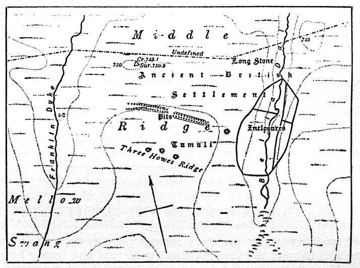
This is the megalithic section of the Ure Swale Landscape, this bit was built by folk from the moors, ‘stone people’ as their contribution the sacred landscape...
“we’ll ‘ave nun o’ yer fangled swaimish henges,
Tell ye what tho’ I can get thee some reet lovely geet big stanes.
Did thee see that job I did at Rudston?”
For me these rude fellas are a gatepost to the North Yorks moors. They stand beside the ‘Great North Road’ and beside the two main routes onto the moorland plateau.
I think I may have cup-mark fever, is it me or..........
No rampant badgers today, But the new housing developments seem to be gradually stalking the site!


Graeme C described these grooves on his website. He speculates that the grooves are natural weathering. I would have to agree with him. The are no pickmarks visible.


From the Mighty Blake’s Jerusalem.
” The blow of his hammer is justice, the swing of his hammer, mercy”
Check the research section then Derbyshire for some interesting images of these carvings.
An account of the reconstruction of the mesolithic dwelling at Maelmin.
I have passed this monolith for over 7 years now and to my shame have never stopped once. It is situated on Hilton Drive, which is a short cut for the Aberdeen taxi drivers rushing frantic offshore workers from the heliport at Dyce to Aberdeen railway station.
I have waited patiently for someone to post it on TMA and can wait no longer.
When I first saw it, it was on a bulding site protected from the JCB and brickies by a fence. Now a nice housing development has grown up around it using the stone as a focal point in the communal forecourt.
Unfortunately the stoney fella still has to be fenced in to protect it from..... what?
Any information?
This information kindly provided by Kammer
Does this stone stand in an area that used to be the grounds of a school?
If it did, it may be the “Aberdeen, Hilton, Lang Stane” which is at NJ 9223 0836. This stone is also known as, “Hilton School, Langstane” which I reckon sounds a bit better.
CANMORE describes it as follows:
“A free-standing block of granite, c.9 to 10 feet in height, which Dr Simpson believes to be a Bronze Age standing stone. It now stands in the grounds of Hilton School and may have been moved when the school was built (Anon 1949), but if so it was replaced in its original position (information from Dr W Douglas Simpson, Librarian, Aberdeen University).”
Anon 1949.“This standing stone is situated on a gentle ENE-facing slope at an altitude of about 80m OD. It stands within a school playground at adjacent to the gates onto Hilton Drive.”
(Newspaper reference cited). NMRS, MS/712/83, visited 11 January 1991.Kammer
“There ev’ry herd by sad experience knows,
How wing’d with fate, their elf shot arrows fly,
When the sick ewe her summer food forgoes,
Or stretch’d on earth the heart-smit heifers lie”
From
Flint Chips, A guide to Prehistoric Archaeology
by Edward T. stevens
1870
An elf shot is a flint arrow head.
The Summary of the NMR Monument Report
“Possible Late bronze Age/Early Iron Age pastoral stock enclosure, believed to have been restored in the Medieval period as a horse corral.

A view of Gefrin from the top of Yeavering Bell.
I am assured that the Henge site is visible when there is a crop in the field.
A massive amount of information was obtained from Brian Hope Taylor’s excavation but as you can see from the highlighted areas in the photo, a lot of the site is still to be excavated, including the henge.
If your planning to visit Roughting Linn it’s worth while tracking down Richard Bradley’s 1997 book “Rock Art and The Prehistory of Atlantic Europe”.
In chapter 7 “Reading Roughting Linn”, he draws parallels with Irish art and explores the idea that the “site itself looks so like a monument”.
Well worth a read.
Here’s what Stan Beckensall has to say about the stone.
“At Homildon Hill, below the Cheviots, on the way to Coldstream from Wooler is the site of a lesser battle in 1402 between the old enemies Percy and Douglas, traditionally marked by a standing stone to the east of the road that in fact marks the site of a prehistoric burial.
Shakespear begins the first part of Henry IV with this battle where the protagonists ‘did spend a sad and bloody hour’.”
Taken from
Northumberland, The Power of Place
Stan Beckensall
Tempus Books
2001


A cinerary urn, burial urn and two food vessels, all taken from Hinderwell beacon and now on display in the Dorman Museum Middlesbrough.


The Milfield Plain from Yeavering Bell showing the location of two of the henges. These henges can be plainly seen as crop marks (or at least they could if I was a better photographer with better kit).


