
Looking south along the east wall of Stowe’s Pound.
Looking south along the east wall of Stowe’s Pound.
The south-east tip of Cornwall has few ancient sites, there is mention of a quoit at Treninnow, (SX418509) which is said to have been big enough to walk under but nothing remains today.
This Barrow can be found within the confines of the Mount Edgcumbe Country Park beside the cricket pitch. (The structure to the right of the barrow in the photo is the pavillion).
I can find no record to say it has been excavated or if it has ever been dated.

With the weather forecasters telling us that the whole country was to be in the grip of an Ice Age by mid week I headed for subtropical St Ives. My partner had a two day conference to go to so I thought I would join her and get in some walking at the same time.
Tuesday 27th Jan 2004
Drove out of St Ives a couple of miles to the hamlet of Towednack. In the porch of the church on the right is a recumbent stone that according to Ian Cooke’s guide to the Tinners Way came from Crete in 2000-1500BC.
{{1,2,22}}
Left the church and took the footpath heading west to Beagletodn. Just after the house a gate on the right (padlocked) has to be climbed over so a track can be followed.
You will find in these two walks that I have not stuck to legal paths but made my own way over what is essentilly wild moorland. This is possible in mid January as the bracken has died down but even so I would reccomend wearing waterproof trousers and taking a stick.
The track twists its way amongst boulders and water features untill you come to a gate near the Pump House featured on the OS map. Go through the gate and turn right. You will soon find yourself walking up between two walls (not for the last time that you will be following ancient trackways). At the top of this track you come to another gate, once the other side of it it is time to head out over the moors towards Sperris Quoit.
{{3,4,5}}
Known as one of the most elusive sites in Cornwall I battled my way through the bracken and gorse in a north westerly direction untill I saw the pile of rocks on the skyline. Don’t be mistaken by Sperris Croft, a smaller pile but nethertheless named on the OS map.
Reaching the rock piles you will get great views over to the coast and also of Zennor Hill. The quoit lays just to the south of the rocks and can be distinguished by one triangular upright. Even from here it is not easy to reach and requires some scrambling amongst the stones. Keep an eye out for the ancient stone wall that runs off to the SEast, did they use stones from the quoit in its construction?
Leaving the rocks walk towards the ruined mine building. Wheal Sperris was a small mine started in the early 1800’s, all around this area are open shafts, water channels and various holes in the ground. If you do leave the path, beware, it’s pretty uneven ground.
Zennor Quoit looms on the horizon to the SWest and the path is easy to follow.
{{6,7}}
Once there I was undecided as to which way to go next, down to Zennor and the Tinners Arms, or onto other sites. The fact that I could see Mulfra Quoit on the horizon weighted my decision and I decided to head south along the old trackway before turning west to the Bishop’s Head and Foot boundry marker. This involved trudging through along muddy paths but the sense of space and the fact that the sun was shining made up for it. On the left hand side of the road beside Kerrowe Cottage is a stone with a nice carving on it, I don’t believe it tobe very old and judging by the “standing stones” opposit possibly a residents artwork.
Follow the tarmaced track to the road then carry on ahead to the “main” road. Cross the road and find the path that leads up over the northern saddle of Mulfra Hill. Yet again I decided to head out cross open moor and took myself off up the side of the hill. A couple of times I thought I had stuimbled across an unknown stone circle lying hidden in the gorse but decided my imagination was playing tricks. There is so much rock up there and at times you can trace a large arc between them, but never mind.
Eventually I picked up a path and found the quoit.
{{10,9}}
I could not have asked for a better view, the Lizard stood out clear as a bell, St Michael’s Mount sat below me and the sun caught the roofs of Newlyn giving them a silver coating. Time for a cup of coffee and a rest.
I suddenly realised time was getting on and I was far from the car. A footpath supposedly runs east from here down to the road but somewhere along the way I lost it and just plunged down the hillside dwarfed by boulders before reaching a forest of Rhododendrons.
I had thought of visiting the Tyre Menhir but time was getting on so I headed to Tyre Farm and turned left along another muddy footpath. Reaching a large Badger holt the path carries on cross a field to a gate beside a small pond (puddle!). In the next field a new fence has been eracted and the route of the path is not clear. However what is marked on the OS map as a round wall around a shaft interested me, is it just a round wall or is it a hillfort?
{{11}}
I climbed over the new fence at the far end of the field having decided there was no way through the hedge and skirted the pond before finding a rusty gate hidden in the undergrowth. It was impossible to open so I climbed over, disturbing a fox in the process. Turn left along the valley and you soon come back out onto the Kerrowe track, turn right.
THe simple way back from here is to follow the bridleway around the south side of Amalveor Downs to Embla Vean then by road to Towednack. I chose a slightly longer route heading more to the south but this did not include any sites of TMA interest except for a couple of tumuli sat overgrown in fields.
The walk took me about 5 hours including stops and it’s not just a trudge between quoits it’s a walk that offers lots more, space, views, and if like me you don’t meet anyone all day, solitude.
28th January 2004
Started day 2 at the carpark beside the engine houses of Carn Galver mine (on the B3306). It was here that my love affair with Penwith began. On a blustery day in Feb 1987 a friend gave me my introduction to rock climbing, if you want to get close to this landscape try hanging on to it by your fingers whilst the waves crash 200ft below you.
Today I head away from the sea, up the footpath/stream that runs along the west side of Carn Galver.
{{12,13}}
I have been up amongst the rocks before so today I carry on to the crest of the hill untill I come to a crossroads of paths. Turning right brings me to the field in which the Maen Scryfa stands.
{{14}}
Sadly the sun is right behind the stone so reading the inscription is not easy and photgraphing it impossible. I am struck by the contrast between lush green fields, stone walls and barren moorland. The dead bracken has turned much of the landscape a dull brown colour, only turning gold when the sun hits it at the right angle.
From the maen Scryffa it is a short walk to the men-an-tol, all is good there and after a short rest I carry on in the direction of Greenburrow Engine House (commonly known as Ding Dong).
Just after passing the little stream I noticed a pile of boulders on the right hand side. Amongst these and just beside the path is a square pit. Gorse and hawthorn grow out of it and it is full of water. I plunged my stick it and found it had a bottom, not far down. Like the “Hillfort” yesterday could this be an undiscovered cairn? or is it a mining relic, I will do some research and see what i can find out.
Ding Dong reached and explored (I wont bore you with mining details) I headed back towards Boskedndan circle.
{{15,16}}
The footpath is thin and runs through gorse and bracken but by following the wall I found my way to a cairn on the south end of the ridge. This lays buried amongst gorse, but with most of the other bracken etc dead it was possible to make out the stones that form the cairn.
The ridge runs north towards Carn Galvers mighty south peak and the stone circle is soon reached. It is rather a wet area in winter and a couple of times I was glad of my stick and high sides of my boots. I missed the standing stone but did explore the tumuli at the north end of the ridge before charging out across the moor to Little Galver, the rocky luump to the east. This was hard going! I wouldn’t reccomend it but I had decided I wanted to visit the quoit at Bosporthennis.
After a lot of hard work I reahed the walls that surround the quoit. Wow! this is a stoney landscape but imagine how many stones were used to build these walls? Up to 4ft thick inplaces and about 5ft tall we marvel at what it took to build the monuments but think how much work went into building these. And how old are they? who knows, some say the field patterns down here date back to the bronze age.{17,18,19,20}}
Having visited the quoit I head back to the road down another vague footpath before following the road back to the car. Looks like I am in time for a pint and a bowl of fish soup at the Gurnards Head
{{21}}
.


The story behind the photo.....
It is early October 1990. I have driven all the way from Cornwall to Fife in a 1000cc Suzuki 4x4 with a dodgy radiator. After a few days in the Kingdom to recuperate and take on liquid (me, not the car) me and Brian head north to bag a hill or two.
We reach a pub in the middle of nowhere as the “sun” sets over the hills. Here we eat before carrying on up the road to the foot of Ben Hope. It is dark by the time we reach the broch....and it is also blowing a gale. The car has only got a canvas top but with the spirit of adventure flowing through our veins we settle down for the night.
Settling down means several spliffs, a packet of chocolate hob-nobs and John Peel on the radio. My lasting memory of that night is the cold, the rain and a Vietnamese version of “A hard rains gonna fall”.
Daylight arrives at last and the full glory of Sutherland is upon us. It is a land of rock and water and very little else. The broch stands proud beside us, the only thing that could have withstood last nights storm. If I remember rightly it has inner walls and a passage way all the way round inside. We breakfast within its shell before setting out up Ben Hope.
That’s another story...what a beast of a mountain. It was so cold we got to the top and turned right round and came straight back down.
As for Sutherland, it is a wonderful wild place. I am not sure how many TMA sites there are to visit but the landscape is just stunning. Sandwood Bay at the far North West tip is possibly one of the finest beaches in the UK.
One day I might get back there.
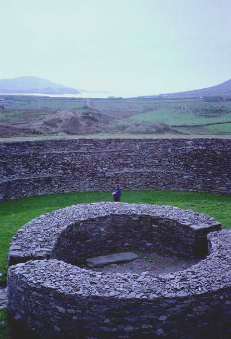
Visited this place about 6 years ago on a hitch-hiking tour of Cork and Kerry. Having been dropped off in the town of Cahersiveen during a funeral we booked into the local hostel and then walked over the bridge to the north of the town. Heading west we came across this fort, at the time I was not what you would call well up on things ancient but remember being overwhelmed by the size of the place. The walls towered above us and all seemed so clean, no greenery growing out of the gaps etc. Kathy, my partner, climbed up the inner steps to the top of the wall and then had a “moment” when she realised she had to then go down!
Looking back at the OS map I realise how much we missed in the area, must make a note to go back....with our own transport.
Nearby to the fort is a wonderful old medieval castle, half of it has fallen down giving it the look of one of those cross section drawings you see in books.
5.3.04
First time at Carn Uny for a few years, work has been done since I was last here. The fougou is dry!, last time I came I could have done with wellies. Also the chamber has been enclosed more with now only a small hole in the roof.
Better still, I have the place to myself. I sit in the chamber and listen to the water dripping off the walls. Sunlight breaks through every so often catching the moss.
After a while it is time to go, duty calls up county. I will be back again, but I bet it won’t be so peaceful.
5.3.04
Perhaps it’s me, but...
I have read so much about this circle on the TMA that I just had to visit it. I walked in along the farmtrack (wasn’t too sure about driving in) and took the footpath towards the circle. Early March, only a few days since West Cornwall had a unusual amount of Snow, the path was fairly muddy.
Because of its reputation on the site I was expecting a hidden magical place.....imagine my dissapointment when I opened the gate and there in front of me was a farm with modern barns etc. I admit, the circle is lovely, although on this grey day it is not at its best. I walked around it, hugged the quartz stone (the farm out of site) and tried to get some of that feeling that many of you quote.
Nothing....I took some photo’s and trudged back to the car and drove to Carn Uny, where I had the fougou all to myself........
“In going or returning from the circle a pile of rocks is passed on which are several cavities, two of them resembling the impressions of human feet, but much larger. They are called the “Giant’s Footsteps”. The cairn is known as Careg or Creeg Tol, the holed rock.
JT Blight “A week at The Land’s End” 1861
7.3.04
After spending most of the day hunting down 19th C archaeology on the western edge of the moor there was just time to take a walk over to this wonderful circle.
Easy to reach from the A30 but still gives a feeling of being away from the modern world (if you turn your back on the telegraph pole).
The sun came out for me to take a few photo’s (won’t bother submiting, same as others on already), but then the rain came down and I had to run for the car. Such is March on Bodmin Moor!
Has anyone found out what the M and C carved on the centre stone denote? I would think it has been used as a boundry marker, any idea’s?
The tor is best known for the small church perched on its peak, but on closer inspection the remains of a large hillfort or settlement can be found on the northern side of the tor. The guide book in the church says they date from the Iron Age and at present I can find no other info to say if this is wrong or right.
The tor is easy to find (it can be seen for miles around) by heading north out of Tavistock towards the village of North Brentor. There is a good carpark beside the road and the walk up to the church takes you through the remains of the settlement.
Whatever your views on Christianity, a visit to the Church is worth it, if only for the views.
Just to the south-west of the tor there is marked on the OS map a row of tumuli running down from a point called the beacon.
With the weather forecasters telling us that the whole country was to be in the grip of an Ice Age by mid week I headed for subtropical St Ives. My partner had a two day conference to go to so I thought I would join her and get in some walking at the same time.
Tuesday 27th Jan 2004
Drove out of St Ives a couple of miles to the hamlet of Towednack. In the porch of the church on the right is a recumbent stone that according to Ian Cooke’s guide to the Tinners Way came from Crete in 2000-1500BC.
{{1,2,22}}
Left the church and took the footpath heading west to Beagletodn. Just after the house a gate on the right (padlocked) has to be climbed over so a track can be followed.
You will find in these two walks that I have not stuck to legal paths but made my own way over what is essentilly wild moorland. This is possible in mid January as the bracken has died down but even so I would reccomend wearing waterproof trousers and taking a stick.
The track twists its way amongst boulders and water features untill you come to a gate near the Pump House featured on the OS map. Go through the gate and turn right. You will soon find yourself walking up between two walls (not for the last time that you will be following ancient trackways). At the top of this track you come to another gate, once the other side of it it is time to head out over the moors towards Sperris Quoit.
{{3,4,5}}
Known as one of the most elusive sites in Cornwall I battled my way through the bracken and gorse in a north westerly direction untill I saw the pile of rocks on the skyline. Don’t be mistaken by Sperris Croft, a smaller pile but nethertheless named on the OS map.
Reaching the rock piles you will get great views over to the coast and also of Zennor Hill. The quoit lays just to the south of the rocks and can be distinguished by one triangular upright. Even from here it is not easy to reach and requires some scrambling amongst the stones. Keep an eye out for the ancient stone wall that runs off to the SEast, did they use stones from the quoit in its construction?
Leaving the rocks walk towards the ruined mine building. Wheal Sperris was a small mine started in the early 1800’s, all around this area are open shafts, water channels and various holes in the ground. If you do leave the path, beware, it’s pretty uneven ground.
Zennor Quoit looms on the horizon to the SWest and the path is easy to follow.
{{6,7}}
Once there I was undecided as to which way to go next, down to Zennor and the Tinners Arms, or onto other sites. The fact that I could see Mulfra Quoit on the horizon weighted my decision and I decided to head south along the old trackway before turning west to the Bishop’s Head and Foot boundry marker. This involved trudging through along muddy paths but the sense of space and the fact that the sun was shining made up for it. On the left hand side of the road beside Kerrowe Cottage is a stone with a nice carving on it, I don’t believe it tobe very old and judging by the “standing stones” opposit possibly a residents artwork.
Follow the tarmaced track to the road then carry on ahead to the “main” road. Cross the road and find the path that leads up over the northern saddle of Mulfra Hill. Yet again I decided to head out cross open moor and took myself off up the side of the hill. A couple of times I thought I had stuimbled across an unknown stone circle lying hidden in the gorse but decided my imagination was playing tricks. There is so much rock up there and at times you can trace a large arc between them, but never mind.
Eventually I picked up a path and found the quoit.
{{10,9}}
I could not have asked for a better view, the Lizard stood out clear as a bell, St Michael’s Mount sat below me and the sun caught the roofs of Newlyn giving them a silver coating. Time for a cup of coffee and a rest.
I suddenly realised time was getting on and I was far from the car. A footpath supposedly runs east from here down to the road but somewhere along the way I lost it and just plunged down the hillside dwarfed by boulders before reaching a forest of Rhododendrons.
I had thought of visiting the Tyre Menhir but time was getting on so I headed to Tyre Farm and turned left along another muddy footpath. Reaching a large Badger holt the path carries on cross a field to a gate beside a small pond (puddle!). In the next field a new fence has been eracted and the route of the path is not clear. However what is marked on the OS map as a round wall around a shaft interested me, is it just a round wall or is it a hillfort?
{{11}}
I climbed over the new fence at the far end of the field having decided there was no way through the hedge and skirted the pond before finding a rusty gate hidden in the undergrowth. It was impossible to open so I climbed over, disturbing a fox in the process. Turn left along the valley and you soon come back out onto the Kerrowe track, turn right.
THe simple way back from here is to follow the bridleway around the south side of Amalveor Downs to Embla Vean then by road to Towednack. I chose a slightly longer route heading more to the south but this did not include any sites of TMA interest except for a couple of tumuli sat overgrown in fields.
The walk took me about 5 hours including stops and it’s not just a trudge between quoits it’s a walk that offers lots more, space, views, and if like me you don’t meet anyone all day, solitude.
28th January 2004
Started day 2 at the carpark beside the engine houses of Carn Galver mine (on the B3306). It was here that my love affair with Penwith began. On a blustery day in Feb 1987 a friend gave me my introduction to rock climbing, if you want to get close to this landscape try hanging on to it by your fingers whilst the waves crash 200ft below you.
Today I head away from the sea, up the footpath/stream that runs along the west side of Carn Galver.
{{12,13}}
I have been up amongst the rocks before so today I carry on to the crest of the hill untill I come to a crossroads of paths. Turning right brings me to the field in which the Maen Scryfa stands.
{{14}}
Sadly the sun is right behind the stone so reading the inscription is not easy and photgraphing it impossible. I am struck by the contrast between lush green fields, stone walls and barren moorland. The dead bracken has turned much of the landscape a dull brown colour, only turning gold when the sun hits it at the right angle.
From the maen Scryffa it is a short walk to the men-an-tol, all is good there and after a short rest I carry on in the direction of Greenburrow Engine House (commonly known as Ding Dong).
Just after passing the little stream I noticed a pile of boulders on the right hand side. Amongst these and just beside the path is a square pit. Gorse and hawthorn grow out of it and it is full of water. I plunged my stick it and found it had a bottom, not far down. Like the “Hillfort” yesterday could this be an undiscovered cairn? or is it a mining relic, I will do some research and see what i can find out.
Ding Dong reached and explored (I wont bore you with mining details) I headed back towards Boskedndan circle.
{{15,16}}
The footpath is thin and runs through gorse and bracken but by following the wall I found my way to a cairn on the south end of the ridge. This lays buried amongst gorse, but with most of the other bracken etc dead it was possible to make out the stones that form the cairn.
The ridge runs north towards Carn Galvers mighty south peak and the stone circle is soon reached. It is rather a wet area in winter and a couple of times I was glad of my stick and high sides of my boots. I missed the standing stone but did explore the tumuli at the north end of the ridge before charging out across the moor to Little Galver, the rocky luump to the east. This was hard going! I wouldn’t reccomend it but I had decided I wanted to visit the quoit at Bosporthennis.
After a lot of hard work I reahed the walls that surround the quoit. Wow! this is a stoney landscape but imagine how many stones were used to build these walls? Up to 4ft thick inplaces and about 5ft tall we marvel at what it took to build the monuments but think how much work went into building these. And how old are they? who knows, some say the field patterns down here date back to the bronze age.{17,18,19,20}}
Having visited the quoit I head back to the road down another vague footpath before following the road back to the car. Looks like I am in time for a pint and a bowl of fish soup at the Gurnards Head
{{21}}
.
I didn’t read the notes for here beforehand so I was only expecting the “cheesewring”. Missed the embanked avenue on the way up. Could have had something to do with the local hunt and the supporters riding past on bikes and quads.
Somewhat spoilt things.

Brown Willy may be the highest point in Cornwall but Roughtor beats it hands down when it comes to rock formations.

Didn’t quite get down to the circle this time. Heavy downpours and the arrival of the local hunt kept me high on Rough Tor. Saying that there can not be many places in the British Isles where you can look down on a circle like this. There it sits, a ring of dots on a golden brown carpet. next time...


T’other side of the wall from the Devil’s Stone, could this be the Devil’s Backside?


The east Cairn showing the remains of a building used during WW2 by the local Home Guard.

Looking from the cairn down the wall to the “Quoit”. The two gray hills in the distance are spoil tips from disused clay works.

There is some discussion over wheather or not this is a quoit or just a well balanced group of stones.
It lies on the northern slope of Carburrow Tor and can be easily found by following the remains of an ancient wall from the eastern cairn.
I have also been told that there is some talk of it being a pointer stone....but you will have to ask Cornwall Archeology Unit about that.

Looking west at the end of a perfect day, the cairn on Carburrow Tor stands out.


