Kammer

Kammer

All posts expand_more 351-400 of 1,860 posts

Bronze Age Skeletons Found in Dig

From an article published on the BBC News web site on 28th January 2005:

Archaeologists have unearthed a unique site in Kent which they claim contains the best preserved examples of Bronze Age skeletons.

The discovery was made in a six-month excavation of a plot of land in Ramsgate, which is due to be the site of a new housing development.

The location has not been revealed because of its national importance.

Archaeologist Darren Godden said the find would help explain what happened to human remains during the Bronze Age.

Read the full article...

Image of Airigh Na Beinne Bige (Stone Circle) by Kammer

Airigh Na Beinne Bige

Stone Circle

Taken 1st August 2004: Looking approximately south west.

William is helping me out by standing in what Margaret and Gerald Ponting describe as a ‘damp hollow’ representing a probably stone socket.

Image credit: Simon Marshall
Image of Callanish (Standing Stones) by Kammer

Callanish

Standing Stones

An approximate plan of Calanais, based on the numbering system devised by Admiral Somerville in 1912. The grey circles indicate stones that are not in their original position (18A is missing and 35 is probably the tip of 28, re-erected).

The missing numbers relate to stones incorporated in the chambered cairn (indicated by the grey square).

Image credit: Simon Marshall

Clach Ard

31st July 2004: I failed to visit this stone, even though we stayed the night in Uig. Just ran out of time. However, I did see it from the quayside in Uig, armed with binoculars and a Landranger map. As we sailed away on the ferry I watched it wistfully (the one that got away).

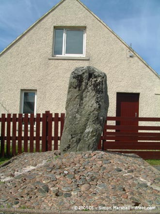
Stonefield

Visited 1st August 2004: Having missed this stone when I visited in ‘95 I was pleased to see it ‘in the flesh’. This is one of those extremely accessible sites that you can drive right up to. Compared to its neighbours (with the possible exception of Olcote) it’s extremely unglamorous, but there’s something intriguing about the contrast of old and new here. At least Stonefield hasn’t been chopped in two by a road!

Image of Callanish (Standing Stones) by Kammer

Callanish

Standing Stones

Taken 1st August 2004: Stone number 9 viewed from the south, standing alone to the south west of the circle. One theory for the strange position of this stone is that it forms a lunar alignment with stone 34 (the tooth shaped stone).

In this photo you can barely see stone 34 (it’s the largely obscured stone in the bright sunshine on the right of the shot). More obvious is the central megalith (number 29) and stone 47, both to the right of stone 9.

Image credit: Simon Marshall
Image of Callanish (Standing Stones) by Kammer

Callanish

Standing Stones

Taken 1st August 2004: Stone 35, which probably isn’t a standing stone in its own right at all, but part of stone 28.

During excavation in 1981 this stone was found to have been erected in concrete during the 19th Century. It has also been broke at some stage, then mended.

Image credit: Simon Marshall
Image of Callanish (Standing Stones) by Kammer

Callanish

Standing Stones

Taken 1st August 2004: An unusual view of stone number 19 as seen from the east, with two large lumps of green-horn (a naturally occurring feature of Lewisian gneiss) sticking out of it.

This is the stone that lost it’s tip in the late 19th Century only to have it reinstated in 1978 after Margaret Curtis (formerly Margaret Ponting) found it in a nearby wall.

Image credit: Simon Marshall
Image of Callanish (Standing Stones) by Kammer

Callanish

Standing Stones

Taken 1st August 2004: Stone number 4 (or the Pixie-Hat as I like to call it) viewed from the east.

This is positioned in the northern section of the site, at the southerly end of the eastern row. It’s the penultimate stone before the circle.

Image credit: Simon Marshall

Film Studio Plan Withdrawn

According to Perth and Kinross Council, plans for 312 hectares of film studio and housing have now been withdrawn. That’s good news for the Belhie stone and anything else that may lay hidden in the surrounding countryside!

Ancient Rock Carvings go Online

From an article published on the BBC News web site on 14th January 2005:

Archaeologists have discovered more than 250 new examples of prehistoric rock carvings, it has been revealed.

The panels were unearthed during a two-and-a-half year search of the moorlands of Northumberland by Newcastle University archaeologists.

They will feature on a new website featuring 6,000 images, which is thought to be the most comprehensive of its kind in the world.

The carvings are thought to have been made between 3,500 and 6,000 years ago.

Among the new discoveries is a collection at Goatstones, near Wark, where 14 carved stones were recorded for the first time.

Read the full article...

Cuidrach Stone Setting

Visited 30th July 2004: Armed with insuficient notes and a grid reference I tried to find this circle. I found some stones that weren’t conclusive, and subsequent research suggests that these are nothing to do with the circle.

So, where are the stones I was looking for? They’re not exactly tiny, so how did I manage to miss them? I was searching to the south of the little road to Cuidrach, but I’m not 100% sure that’s right. Hopefully someone else will have better luck than me.

Eyre

Visited 30th July 2004: I left the others in the car and walked to the stones on my own (they were suffering from megalith fatigue). I made my way across the field without any adverse bovine attention, and got a few shots of the stones before running out of memory on the digital camera.

The stones are pleasantly perched on the edge of Loch Eyre. They’re not especially close to the water, and with the lower sea levels of the Bronze Age it would be a mistake to think of the stones as strongly linked to the modern loch. These two megaliths are big and bold. They leave you in no doubt that someone wanted to make a statement here!

Miscellaneous

Cuidrach Stone Setting
Stone Circle

The following text is an excerpt from the 1989 edition of Discovery and Excavation in Scotland (page 44) describing the circle:

Snizert Parish
NG386596 Stone Circle
Situated a third of a mile south of the Cuiderach road, and 20m SE of a telegraph pole at a height of c40m. Below a small knoll and in boggy ground is a circular setting of 4 upright and two recumbent stones. It measures 3.4m NE to SW and c3.2m NW to SE, with stones standing to a maximum height of 1.1m. Where no surface stones appear to indicate breaks in the circle, probing has located stones now buried at these points.

This site is not on the NMR.

Miscellaneous

Borve (Isle of Skye)
Stone Row / Alignment

The NMR, available via the PastMap web site, describes the stones at Borve:

Stone Circle (Remains), Clachan Erisco
There are three erect stones forming a very flat curve, the axis of the extreme stones running NW-SE. The stone to the E, an irregular six-sided prism, is 6ft high and 6 1/2ft in girth at the ground; the central stone, 13 3/4ft distant, is 5 1/2ft in height, 3ft 2ins in breadth and 13ins thick; while the third stone, 13 1/2ft further on to the NW, measures 3 1/4ft in height, 2ft 8ins in width and 15ins in thickness; the two latter are set up radially. In the line of the curve formed by these three stones, at a distance of 21ft 10ins to the NW, is a fourth stone 1 1/2ft high, 2ft 4ins broad and 11 ins thick, which may have been one of the component parts of the ring of stones.

In the immediate neighbourhood are three prostrate monoliths, which possibly had formed part of the circle, as no other stones of their magnitutude or appearnace are to be found in the adjoining drystone dykes. One of these is built into a dyke about 20ft to the W of the standing stones and measures 6ft long, 2ft broad and 12ins thick; another lying within two yards of it is 4 1/2ft long, 1 1/2ft broad; and the third, on the opposite side of the road 50 yards to the E, is 5ft 2ins long, about 2ft in breadth and 8ins thick.

Borve (Isle of Skye)

Visited 30th July 2004: This is one of those sites where access couldn’t be much better. Wheelchair, pushchair and car friendly.

Three stones remain standing in the village of Borve, overlooked by modern houses on the other side of the road. They are thought by some to be the remains of a stone circle. The row is aligned approximately in a north-westerly (or south-easterly) direction, with the road running parallel. The smallest stone is in the north west but the other two are approximately the same height. Look out for the friendly sheep. They’ll want to know what you’re looking at.

Cnoc Ullinish

Visited 30th July 2004: What a charming place! The views are great, but the site itself is also interesting. The remaining stones are relatively large, indicating something of the way it once looked. This must have been something special when it was in one piece.

Access to the site isn’t too tricky on foot, but the route in isn’t wheelchair friendly. Cnoc Ullinish is quite close to the road, and there’s space to parking isn’t a problem. You’re unlikely to bump into any fellow visitors.

An Sithean

Visited 30th July 2004: An Sithean is easy to find, sitting just off the B8083. Parking is easy, and it’s a short but moderately steep climb up to the stones (not wheelchair friendly).

The stones are dominated by the peak Beinn na Caillich, but no less significant is Broadford River which lies between the two. This landscape is not lacking in drama!

An Sithean sits enigmatically on top of a hillock, with one remaining standing stone on the very top. The rest of the stones are on the south side of the mound. What appear to be two or more natural ridges fan out from the central point of the mound.

What is this place? If it’s a chambered cairn then most of it became road building material a long time ago.

Image of An Sithean (Chambered Cairn) by Kammer

An Sithean

Chambered Cairn

Taken 30th July 2004: Against the horizon the remaining stones appear spine-like, but this is a bit deceptive. An Sithean is a difficult site to interpret!

Image credit: Simon Marshall
Image of An Sithean (Chambered Cairn) by Kammer

An Sithean

Chambered Cairn

Taken 30th July 2004: The largest remaining stone at An Sithean, viewed from the north west. From the road this is the most obvious sign that the hill isn’t entirely natural.

Image credit: Simon Marshall
Image of Little Meg (Stone Circle) by Kammer

Little Meg

Stone Circle

Taken 29th July 2004: I don’t think I’m going out on a limb if I say this site is best visited during the winter when there’s no excessive foliage. This rather crappy photograph indicates just how little we could see.

Image credit: Simon Marshall

Miscellaneous

Alderley Edge Copper Mine
Ancient Mine / Quarry

The NMR, available via the MAGIC web site, describes the Alderley Edge Copper Mine:

The copper has been extracted at this location from the Bronze Age to the 19th century. The underlying sandstone is known as Engine Vein conglomerate.

The eastern half of the site is a steep-sided canyon formed by successive periods of opencast cutting down into the fault line and thereby forming an opencut about 15m deep. The floor of the trench has been capped with concrete to make it safer for the public and so the present floor is about 8m from the surface. The cutting of this deep trench has bisected several shallow pits which were formed by miners using stone hammers to extract the copper nodules. This shallow open pit working dates from the Bronze Age and creates characteristic peck marks in the rock face which may be compared with examples from Europe and the Near East. In addition, many broken and discarded stone axe-hammers have been found at and near the site over the last 100 years.

These are formed from hard river pebbles with a groove pecked around the centre to attach a handle. These are also comparable with examples from both Israel and Spain which are associated with Bronze Age workings. Evidence for Roman mining at ground level and below the surface has also been recorded at this site. A bisected shaft with an inclined access and rock-cut notches for a possible windlass mounting are visible on the northern side at SJ86077747.

These represent Roman or possibly medieval mine workings. In the canyon side below the Bronze Age surface workings there are rock faces representing hand-picked extraction dating from mining operations from the medieval period through to the early 18th century and also traces of cobalt and copper extraction by the blasting which was happening from 1857. Other rock-cut features are now hidden from view by the concrete cap in the floor of the trench.

The eight figure grid reference given is SJ86037748.

Miscellaneous

Armada Beacon
Round Barrow(s)

The NMR, available via the MAGIC web site, describes the Armada Beacon:

The monument includes the earthwork and buried remains of a stone-built beacon platform on the summit of Beacon Hill, Alderley Edge. The earthen mound on which it has been constructed is considered to have been a bowl barrow of Bronze Age date. This barrow mound is large and may have been augmented when the beacon was constructed on the summit.

The mound is of earth with some stone incorporated in the structure. It stands approximately 3m above ground level and is 25m wide at the base. The top of the mound was levelled for the foundations of a stone building to support the beacon with its fire basket and to store material such as pitch for the fire itself. This building was constructed in the 16th century and restored in 1799 on the foundations of the original building. The beacon building was blown down in 1931 and today only the foundations survive.

The eight figure grid reference given is SJ85847773.

Iron Age Fort Defended From Raiding Rabbits

From an article by David Prudames, published on www.24hourmuseum.org.uk on 20th December 2004:

During the Iron Age it stood up to marauders, protecting the people of ancient Leicestershire against anyone that might do them harm. But a couple of thousand years later Burrough-on-the-Hill was in need of a little defending of its own.

They might not sound as fearsome as a neighbouring tribe, or even the might of the Roman Empire, but the ancient hill fort has recently been under attack from the local rabbit population.

However, under the Department for the Environment, Food and Rural Affair’s Countryside Stewardship Scheme, farmer and Country Park Ranger, Tim Maydwell, has been fighting back.

Read the full article...

Unique Rock Find Amongst Archaeology Yielded by Moorland Fire

From an article by Richard Moss, published on www.24hourmuseum.org.uk on 20th December 2004:

Archaeologists are pondering one of the most intriguing archaeological discoveries for some years after a fire revealed a unique carved stone thought to be 4,000 years old.

The find came to light after a blaze in 2003 at Fylingdales near Whitby consumed two and a half square kilometres of heather moorland before being brought under control by hundreds of fire fighters and a water-dumping helicopter.

However, in the fire’s aftermath archaeologists were astonished to find a vast array of archaeological remains – uncovered by the intensity of the blaze, which burnt away much of the peat.

“The fire had a devastating impact, but it also revealed an astonishing archaeological landscape,” said Neil Redfern, English Heritage Inspector of Ancient Monuments.

Read the full article on the 24 Hour Museum web site or see the BBC article about the same news item.

500,000 Year Old Axe Find in Quarry

From an article by David Prudames, published on www.24hourmuseum.org.uk on 16th December 2004:

A Stone Age hand axe dating back 500,000 years has been discovered at a quarry in Warwickshire.

The tool was found at the Smiths Concrete Bubbenhall Quarry at Waverley Wood Farm, near Coventry, which has already produced evidence of some of the earliest known human occupants of the UK.

It was uncovered in gravel by quarry manager John Green who took it to be identified by archaeologists at the University of Birmingham.

“We are very excited about this discovery,” enthused Professor David Keen of the university’s Archaeology Field Unit.

Read the full article...

Budloy Stone

Visited 21st June 2004: We walked to Budloy Standing Stone from the Dyffryn Stones thinking that the footpath would continue to be relatively easy going. We were wrong. After Dyffryn it deteriorates, getting narrow and overgrown in places. There’s a stream to cross, then the path follows the bank of a tiny tributary with the inevitable insects. Lastly, after Budloy Farm, there were shoulder high grass and stinging nettles to get through!

The stone itself is elegant and feels relatively isolated even though it’s not far from the farm. By the time we got there the kids had had enough. We stopped to have a drink and apply sun cream (it was scorching!). I rattled off some photos and we made use of Budloy Farm track (not a public footpath) to escape further suffering and return to the car along the road.

Maybe this is a site worth visiting in the winter when the undergrowth and insects are less of a problem.

Dyffryn Stones

Visited 21st June 2004: This site was the highlight of our Summer Solstice. We parked on the little lane that runs to the south of the Dyffryn Stones next to a dilapidated set of farm buildings (SN05502825) Dyffryn Stones. The walk from there to the stones was pretty easy, but a bit on the muddy side.

The stones themselves are in a field adjacent to the public footpath. The size of them was surprising, and the fact that there are stones still standing. It’s much more circle-like than I anticipated. If the remaining standing stones are kerb stones, then this is a very unusual site. Was this once a circular chambered cairn? There’s quite a bit of foliage in the centre of the cairn, but it’s easy enough to see that there’s not much sign of a chamber. Very curious.

Another curious thing about Dyffryn are a couple of corrugated stones on the northern side of the cairn. In cross section they look like a ripple. It’s hard to imagine this effect being artificially created, so it’s likely that these stones were chosen specifically for their look.

Access to this site is reasonably good, and it’s well worth the visit. Not as glamorous as Gors Fawr, but more mysterious.