Kammer

Kammer

All posts expand_more 251-300 of 1,860 posts

Miscellaneous

Druim Dubh
Stone Circle

In Issue 147 (page 98) of Current Archaeology (published 1996), there’s an article describing the discovery of Druim Dubh. This is the taster:

A new stone circle has been discovered at Druim Dubh on the Isle of Lewis in the Outer Hebrides. . Local archaeologist Margaret Curtis describes how she discovered the circle while travelling to Stornoway on the bus to do her shopping, and scanning the countryside: and there it was, a fallen stone circle sitting in peat cutting, beside the road!

A terribly constructed paragraph, but it serves it’s purpose.

Druim Dubh

Visited 6th August 2004: This is an easy site to find thanks to the Halfway Garage. My visit was extremely brief because we were pressed for time, but to be honest there isn’t a great deal of ambience to be soaked up here.

Stone 10

Visited 6th August 2004: Relatively easy to find if you have the grid reference or some local knowledge, but we had neither. It took a while to track down Creed Lodge, but once we’d found that is was easy. Watch out for the traffic though!

Miscellaneous

Cnoc Ceann a’Gharraidh
Stone Circle

If you’re planning on visiting Stournaway (and most people do) why not visit the mysterious Stone 10 that once made up part of Cnoc Ceann a’Gharraidh.

Incidentally, according to Margaret Ponting the name Cnoc Ceann a’Gharraidh is pronounced ‘kroc kyain a gaa-ree’.

Miscellaneous

Stone 10

In The Stones Around Callanish (ISBN: 0 903960 67 2) the Pontings give an account of the strange history of this stone.

It was first described in 1857 when John Lynton Palmer surveyed Cnoc Ceann a’Gharraidh (aka Callanish II) and in 1858 John Stuart drew the circle and Stone 10, claiming that the latter had possible Ogham script on it (not something taken very seriously now). At some stage subsequently the stone disappeared from the site, removed to Stournaway for its protection. The Pontings set out to find out what had happened to it:

Sir James Matheson had the stone erected opposite Creed Lodge gates... It remained standing there for about 60 years. In 1919, while the walls of the castle grounds were being repaired after wartime neglect, the stone was partially broken up for building material. The workmen concerned were severely reprimanded for this action.

The Pontings suggest that the boulder that now situated opposite Creed Lodge (NB4047032617) may be the remains of Stone 10.

Image of Stone 10 by Kammer

Stone 10

Taken 6th August 2004: Viewed from above, with the southern end of the stone nearest the camera.

Image credit: Simon Marshall
Image of Stone 10 by Kammer

Stone 10

Taken 6th August 2004: This is Stone 10 viewed from the west with the A859 and Creed Lodge in the background.

Image credit: Simon Marshall
Image of Callanish (Standing Stones) by Kammer

Callanish

Standing Stones

Taken 6th August 2004: The beige arrow indicates a possible cupmark on stone 29 (the central stone) as identified by Margaret Ponting *.

The black mark above it is a small lumps of green-horn, a naturally occurring feature of Lewisian gneiss.


* Assuming I’ve put the arrow in the right place that is.

Image credit: Simon Marshall

Cnoc Sgeir na h-Uidhe

Visited 6th August 2005: This site isn’t acknowledged by everyone as prehistoric, but having read about it and spoken to Margaret Ponting about it, I was curious. Cnoc Sgeir na h-Uidhe (pronounced kroc skayth na hoo-ya) is on the way to Na Dromannan:

Starting from the A858, park in the lay-by nearest to Cnoc Fillibhear Bheag. Cross the road and follow it, heading away from Calanais, until you are past the cottages on your left (I think you may cross over a cattle grid, but I’m not 100% sure). Here there’s a gate taking you into a small paddock on the other of which is another gate. From this point on you’re in open countryside.

At this point work your way onto the rocky outcrop behind the cottages, and this is where you’ll find Cnoc Sgeir na h-Uidhe. Don’t expect to find it easily!

Miscellaneous

Cnoc Sgeir na h-Uidhe
Standing Stone / Menhir

The significance of Cnoc Sgeir na h-Uidhe (aka Callanish XIV) is hypothesised in the book The Stones Around Callanish (ISBN: 0 903960 67 2) by the Pontings:

...the chief interest of this site is that the small erect stone is east of the circle at Callanish I. Thus for an observer at the main site, sunrise occurs directly above site XIV at the equinox.

Mining hope [sic] for Bronze Age site

From an article published on the BBC News web site on 21st May 2005:

Mining for copper and zinc could return to Anglesey’s Parys Mountain mine after an absence of almost 100 years.

As a result of recent increases in world metal prices, owners Anglesey Mining plc are starting exploratory drilling work.

Finance director Ian Cuthbertson said they were confident of “significant reserves” at the site, which has been mined since the Bronze Age.

Read the full article...

Na Dromannan

Visited 3rd and 6th August 2004: Lou and I visited Na Dromannan on two occasions, partly because I left the camera in the car on the first visit, but also because we were bowled over by the stones and their location.

It’s such a peaceful spot up on the hill overlooking the other big Callanish sites (most clearly Calanais itself). We took the opportunity to sit in quiet contemplation (in a Swarth Fell stylee). You’ve got to make this little pilgrimage if you’re able!


This route is not very exact, so use it as an aide rather than relying on it. I’ve based it on memory and some photos that I took. I wouldn’t recommend the walk for anyone with limited mobility. Pushchairs or wheelchairs are out of the question because of the frequently changing levels of peat. Good footwear with ankle support is advisable, and if it’s been raining be ready to get wet feet.

Starting from the A858, park in the lay-by nearest to Cnoc Fillibhear Bheag. Cross the road and follow it, heading away from Calanais, until you are past the cottages on your left (I think you may cross over a cattle grid, but I’m not 100% sure). Here there’s a gate taking you into a small paddock on the other of which is another gate. From this point on you’re in open countryside.

Keeping to the east of the little hill behind the cottages you should find a peat cutters track. This track starts off being well defined, but very uneven, leading off to the north-east. You can follow the path for about half a mile before it becomes almost impossible to distinguish from the heather and peat. At this point you should change course and head north towards high ground. You should have the lake off to your right at the point when you change course.

This is where the going get tougher. You’ll find yourself going from one heather covered island of peat to another. The ‘valleys’ between each island can get very wet very quickly if it rains. Wherever possible keep on the high ground. The first ‘bump’ to aim for has a couple of distinctive boulders on the summit which make it quite distinctive. Once you’re on the top of that you can potentially see the bump that Na Dromannan sits on. We were lucky because the spoil heaps from the archaeological dig made for an excellent target, but once they’re gone it could be tricky finding the site without a GPS or some top notch map reading.

Road Dig Reveals Iron Age Remains

From an article published on the BBC News web site on 4th May 2005:

Archaeologists have discovered iron age remains under the route of a new bypass around the village of Leybourne.

In a dig before the construction work, ditches containing pottery, burnt daub, charcoal and animal bone were found.

Kent County Council archaeologist, John Williams, said the remains suggested there were Iron Age farming settlements in the area more than 2,000 years ago.

Read the full article...

Image of Na Dromannan (Stone Circle) by Kammer

Na Dromannan

Stone Circle

Taken 6th August 2004: As far as I can gather this is the alleged quarry where the stones for Na Dromannan, and possibly some of the other sites were sourced. It’s just to the west of Na Dromannan.

Louise is in the photo for scale.

Image credit: Simon Marshall
Image of Na Dromannan (Stone Circle) by Kammer

Na Dromannan

Stone Circle

Taken 6th August 2005: One of the southerly stones, with Louise (5ft 6) providing an indication of scale. Behind Lou’s head is the village of Callanish.

Image credit: Simon Marshall
Image of Na Dromannan (Stone Circle) by Kammer

Na Dromannan

Stone Circle

Taken 6th August 2005: Looking approximately south west across the site.

The stone that I interpret as the most south easterly can be seen to the left of the frame. In the distance to the right some of the houses of Callanish village are visible.

Note the weathering on some of the stones indicating the modern ground level prior to excavation.

Image credit: Simon Marshall
Image of Na Dromannan (Stone Circle) by Kammer

Na Dromannan

Stone Circle

Taken 6th August 2005: The stone at (what I think is) the south eastern edge of the site, looking approximately south west towards Loch Ceann Hulabhig.

The big pile of peat is spoil from the Manchester University archaeological dig.

Image credit: Simon Marshall

Iarsiadar Standing Stone

Visited 2nd August 2004: We parked by the Bernera Bridge information board and walked back across the bridge to Iarsiadar. There’s a gate by the road giving access into the field where the stone now stands. The climb up to the stone isn’t too steep, but there’s no path as such.

When you’re up by the stone you just have to imagine that you’re a few metres further west than you actually are.

Bernera Bridge Circle

Visited 2nd August 2004: Just as enigmatic as I’d anticipated, Bernera Bridge is a weird old thing. It’s situation above the channel of Sruth Iarsiadar is a great sensory bonus. The reflection of light (even on a dull day), the sound of the sea, the distant views, and even the modern bridge make it a great spot.

Long before the bridge this was a crossing point to Bernera, but what would it have looked like during the Neolithic? The sea levels were lower, so what did this spot represent to the people who put up the stones?

The Bernera Bridge ‘circle’ could be a lot more accessible than it is, given how close it is to the road. A steep gravel slope leads up to the site, so not ideal for anyone who’s got limited mobility.

Ceann Hulavig

Visited 2nd August 2004: The first site of the day, it was good to meet Ceann Hulavig in the flesh. Shame that the weather wasn’t great, but you can’t have everything. We were pressed for time (not recommended) and so any scope for chilling out and enjoying the place was rather limited. Would have liked to have made a second visit in the sunshine.

Image of Na Dromannan (Stone Circle) by Kammer

Na Dromannan

Stone Circle

Taken 6th August 2005: There was no way I was going to make these photos stitch together in a tidy way, so I decided to make it really obvious where the joins are. This way I’m not passing off a distorted image as the real thing.

The photos were taken from the top of the spoil heap to the south of the site. The village of Callanish is just about visible under the red line on the far left (above the green wheelbarrow).

Image credit: Simon Marshall

Early hominid 'cared for elderly'

From an article published on the BBC News web site on 7th April 2005:

Ancient hominids from the Caucasus may have fed and cared for their elderly, a new fossil find has indicated.
The 1.77 million-year-old specimen, which is described in Nature magazine, was completely toothless and well over 40; a grand old age at the time.

This may suggest that the creature lived in a complex society which was capable of showing compassion.

These hominids – like humans – may also have valued the old for their years of acquired knowledge, researchers think.

Read the full article...

Clach Stei Lin

Visited 4th August 2004: We started off trying to get a view of Clach Stei Lin from the village of Siadar Uarach. You can see it from the end of the cul-de-sac that lies to the north west of the stone, but it’s not a great view.

In the end I approached on foot from the track to the south west of the stone, leaving Louise in the car. At the site there are two obvious stones, one standing (which we’d seen from the village) and the other, much smaller, lieing prone just to the north.

This is one of those places where you know very few people visit, despite being relatively close to the road. If these stones were in souther England they’d be litterred with rubbish and graffiti, but here on Lewis they represent a relatively minor site.

Vive l’indifférence!

Coire na Feinne

Visited 5th August 2004: This is an interestingly placed site. It’s effectively become a garden feature, but it’s a well kept garden, and when we visited the owner was very friendly. She was happy for us to take a look at the stones from the garden side of the boundary.

If you visit, please ask before entering the garden area or taking photos from inside the garden. It would be a shame to upset the people who look after this site, especially as they are so congenial.

Coir Fhinn may not be everyone’s cup of tea, but I rather liked it. Well worth taking a look at if you’re in the area visiting other sites.

The Macleod Stone

Visited 5th August 2004: We approached this one all wrong. It was entirely my fault as well. We parked on the wrong side of the stream near the picnic area, and had to paddle across where the water was shallow. Then we worked our way up the headland, past some serious sand extraction quarries, up to the top then down towards Clach Mhic Leòid. It was an interesting route, but not ideal for the kids. There was a fence to get over before we got to the stone, and at this point I realised we should have done it all differently (presumably parking near the cattle grid).

The stone is big and macho. The views are splendid, but we weren’t blessed with sunshine. There’s a weird sort of notch in the top of the stone (like an inverted arrow), and I couldn’t help but wonder whether it’s an original feature. It could equally be the result of a lightning strike. A ‘must see’ if you’re on Harris, but not as charming as Sgarasta.

Sgarasta

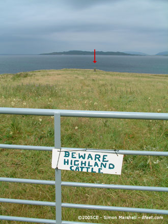
Visited 5th August 2004: On the Ordnance Survey map Sgarasta looks pretty accessible, sitting as it does just off the A859. I hadn’t anticipated the cows though. The farmer had kindly placed a ‘Beware Highland Cattle’ sign on the gate as a warning, but the presence of the cows on the other side of the wall rendered it unnecessary.

In the sunshine the stone and the views looked gorgeous, and I wasn’t about to back down. The cows watched me intently as I climbed over the gate and after a moment of hesitation I decided not to run for the stone. I casually strolled in a respectful arc around the cattle and kept up the same sort of pace until I got to the stone (it unnerved me having my back to them).

What a great stone! What a great view. The mountains and the sand make for a staggering back-drop. I nearly forgot about my bovine audience. Despite the road, this place has a real feeling of solitude. Not much time to enjoy the ambience though because everyone else was waiting in the car. We spent the afternoon on the beach (Bàgh Steingidh) within site of the stone. Highly recommended!

Image of Sgarasta (Standing Stone / Menhir) by Kammer

Sgarasta

Standing Stone / Menhir

Taken 5th August 2004: Testing your commitment to experiencing Scotland’s heritage.

The cattle are lurking just off to the right. The red arrow indicates the stone. Do you run or walk?

Image credit: Simon Marshall
Image of The Macleod Stone (Standing Stone / Menhir) by Kammer

The Macleod Stone

Standing Stone / Menhir

Taken 5th August 2004: Clach Mhic Leòid viewed from the north east, with Gob an Tobha (Toe Head) in the distance.

I’ve no idea what William thinks he is (some sort of super hero I’m guessing) but for the purposes of scale, he was 108cm tall at the time.

Image credit: Simon Marshall
Image of Clach Stei Lin (Stone Circle) by Kammer

Clach Stei Lin

Stone Circle

Taken 3rd August 2004: Viewed from the south east, here is (or should that be ‘are’) Clach Stei Lin. In the distance is the village of Siadar Uarach.

Image credit: Simon Marshall
Image of Clach an Trushal (Standing Stone / Menhir) by Kammer

Clach an Trushal

Standing Stone / Menhir

Taken 3rd August 2004: These masked extremists are archaeologists from Manchester University undertaking a Geophysical survey of the field to the south west of Clach an Trushal. The masks are to ward off midges, mosquitos and other horrid insects that might be lurking in the grass.

Image credit: Simon Marshall
Image of Clach an Trushal (Standing Stone / Menhir) by Kammer

Clach an Trushal

Standing Stone / Menhir

Taken 3rd August 2004: Clach an Trushal viewed from the south east. To the right of the photo in the field to the north east of the stone are archaeologists from Manchester University undertaking a survey of the site.

Image credit: Simon Marshall