Visited 10th August 2004: This is the first ‘proper’ outlier to the stone circle (I can’t see how the more distant stone can be described as an outlier). Contained within the same field as the circle and Outlier 1 you have to double back on yourself a bit from the gate to get to it. It was at this stage in our visit that the severity of the rain really became apparent. We were sodden!
Kammer
Visited 10th August 2004: This was the second Lochbuie site that we came to. The light was very poor thanks to the low cloud and drizzle, but the site was relatively easy to find. The trees sit in amongst the stones making the site a bit of a jumble to interpret.
Visited 10th August 2004: With a foolhardy lack of regard for the weather we set out from our parking spot (NM61552557) and made our way to the ‘Lochbuie’ standing stone (the one furthest away from the circle). In this instance we approached over water-logged ground. The stone itself was difficult to get close to without getting soggy feet. At least the rain wasn’t too bad...
Visited 9th August 2004: Not such much a visit as a drive-by. Caisteal Eoghainn A’ Chinn Bhig is clearly visible from the A849, so I insisted on taking a look from the road.
Despite not getting all that close to the site I was disproportionately excited at seeing my first Crannog. The whole valley has quite an appeal, in a bleak sort of way. In this instance the dire weather seemed a very appropriate backdrop.
Visited 9th August 2004: William and I visited this stone without the others (they opted to stay in the car).
When we visited there was a lot of silage stacked up near the stone tractor in the field and a knackered old tractor (William liked this). The biggest obstacle we faced was mud. The part of the field nearest he gate was awash with it. It took us ages to cover a short distance.
The stone itself is tall and slender, but this I didn’t find the site very inspiring. Perhaps I had the wrong head on for it, or perhaps it was the mud, but I didn’t feel any great urge to contemplate the place for very long.
Visited 8th August 2004: Parking is a bit tricky if you’re visiting Kilninian, and when we visited the giant bracken was quite an obstacle. The stone itself is beautifully positioned, but possibly easier to appreciate in the winter when the undergrowth has died back.
Visited 8th August 2004: Dervaig B is easier to find and get to than the other two Dervaig rows. As a result it’s the most visited of the three. Unsurprisingly, this site isn’t wheelchair friendly.
The row is now just inside a forest plantation, with tall pine tress planted on either side of it. Any intervisibility between Dervaig B and it’s neighbours (if there ever was any) is now hard to imagine. There’s an ambience here though, and the stones are impressively large. Well worth a visit, even for the non-enthusiast.
Visited 8th August 2004: This site is relatively easy to get to, but not by any means wheelchair friendly. It took a couple of passes on the road for me to realise that the cemetery is the landmark we should really have been looking for (much easier to spot than the stones).
Because it’s built into a dry stone wall Dervaig C is unlike the other two neighbouring stone rows. It feels a bit tainted, especially with fencing wire still attached to the largest stone. Not exactly brimming with atmosphere.
I can’t really complain about our visit though. It was the first day of our week on Mull, and we had brilliant sunshine (unaware that it would be chucking it down in buckets for most of the remainder of the week).

Taken 11th August 2004: After the heavy rain we’d been having a little temporary lake had appeared around the foot of the stone.
Image credit: Simon Marshall

Taken 11th August 2005: Looking approximately north east, with the A849 in the distance.
Image credit: Simon Marshall

Taken 11th August 2004: Looking east(ish).
Note how flooded the field was. This was bad weather for visiting stones.
Image credit: Simon Marshall

Taken 11th August 2004: Nice fury lichen!
Image credit: Simon Marshall

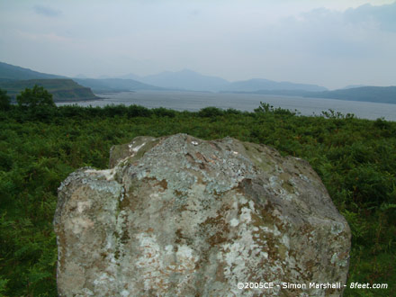
Taken 11th August 2004: Looking approximately north towards Loch Caol.
Image credit: Simon Marshall

Taken 11th August 2004: On an appallingly wet day, here’s a photo of Fionnphort taken from the car.
This is what summer on Mull can be like. Based on Nick’s photos, we should have visited during the winter.
Image credit: Simon Marshall

Taken 10th August 2004: Looking approximately north east at the northern arc of the circle.
Image credit: Simon Marshall
Taken 10th August 2004: Viewed from the south west.
Image credit: Simon Marshall

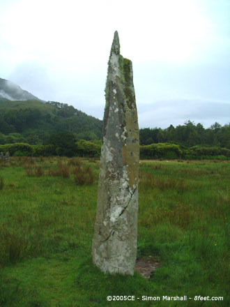
Taken 10th August 2004: Looking north east, with Lochbuie Circle visible to the left of the outlier.
Image credit: Simon Marshall

Taken 10th August 2004: Peering through the rain. Here is the stone with the other outlier and stone circle just about visible in the background.
Louise is obligingly wearing a red coat and standing next to the other outlier. The strange white blob in the sky isn’t a UFO... it’s rain.
Image credit: Simon Marshall

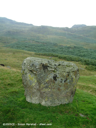
Taken 10th August 2004: The stone viewed from the south east in miserable wet weather.
Image credit: Simon Marshall

Taken 10th August 2004: I call this composition"Tree & Rock”.
Actually there are a couple of ‘rocks’ in the shot. It gives an indication of how the trees are engulfing the cairn.
Image credit: Simon Marshall

Taken 10th August 2004: Viewed from the north (that’s very approximate).
Image credit: Simon Marshall

Taken 10th August 2004: The stone viewed from the south east.
Image credit: Simon Marshall

Taken 10th August 2004: Lochbuie Standing Stone viewed from the north west (I think) with William standing alongside it. Note how water-logged the ground around the stone is.
Will’s strange attire is the result of his bungling parents forgetting his rain gear (he’s wearing my fleece).
Image credit: Simon Marshall

Taken 9th August 2004: Loch Sguabain and Caisteal Eoghainn A’ Chinn Bhig viewed from the A849.
Image credit: Simon Marshall

Taken 9th Auhust 2004: A close-up of the crannog, taken from the A849.
Image credit: Simon Marshall

Taken 9th August 2004: A gratuitous photo of my stone hunting ‘buddy’ William alongside the stone at Gruline, viewed from (something like) the north.
Image credit: Simon Marshall

Taken 9th August 2004: Viewed from the west (I think).
Image credit: Simon Marshall

Taken 9th August 2004: Gruline from a distance. This photo was easy to take (no bull!).
Image credit: Simon Marshall
Taken 8th August 2004: The tip of the stone with Loch Tuath behind it.
Image credit: Simon Marshall

Taken 8th August 2004: Polished by livestock, here’s the pronounced edge of the stone.
Image credit: Simon Marshall

Taken 8th August 2004: With Loch Tuath behind it, here is Kilninian viewed from the north east (approximately speaking).
Image credit: Simon Marshall
Visited 9th July 2005: This is not an easy site to find. For directions detailing how to get to Bedd yr Afanc, take a look at my map and notes. We were blessed with glorious sunshine. The heat was almost too much really. I had Emily (less than two weeks old) in sling on my front and Lou was supervising the boys. We trudged our way to the site. It felt a bit like a scene out of Beau Geste.
Bedd yr Afanc is a modest site, especially when compared to it’s nearest neighbour Pentre Ifan. Having seen photos of the site I knew what to expect, but there’s a danger of disappointment if you’re expecting something like a Breton gallery grave.
I wondered about for a while trying to figure out where the capstones could have ended up, and found one large stone a few metres away from the tomb. Assuming that this is a capstone, why would anyone come to this place and shift a stone that large only a few metres?
Bedd yr Afanc is definitely worth a visit if you’re an enthusiast, but is probably not worth the walk if you only have a casual interest in prehistory. The terrain is relatively level, but by no means wheelchair friendly.

Taken 8th August 2004: Looking along the row.
Image credit: Simon Marshall

Taken 8th August 2004: Louise and William at Dervaig B (Louise is 5ft 6 inches tall).
Image credit: Simon Marshall

Taken 8th August 2004: Not a gratuitous ‘family snap’ but members of my family giving an excellent indication of scale. Here are all three stones viewed from the south west with the cemetery visible in the background.
Image credit: Simon Marshall

Taken 8th August 2004: The largest of the remaining stones in the Dervaig C row, here viewed from the south.
Image credit: Simon Marshall

Taken 9th July 2005: Looking directly down the gallery from the eastern end.
Image credit: Simon Marshall

Taken 9th July 2005: Viewed (approximately) from the north east.
Image credit: Simon Marshall

Taken 9th July 2005: Viewed approximately speaking from the south east.
Image credit: Simon Marshall
Visited 6th August 2004: We asked at the farm before going to see the stones (presumably this was M’Lellan’s croft). The owner was very friendly and didn’t seem to mind us taking a look. The route to the stones takes you across a rocky and seaweed strewn beach, so not recommended for anyone with limited mobility.
The site is relatively easy to find, but not quite so easy to interpret. In contrast to the experiences of some others we found Fang Circle to be a pretty inhospitable place, mainly because of the insects. It may have been the time of day that we visited (late afternoon) or the weather that made it bad, but the midges were a nightmare.
The National monument Record (available via Pastmap) describes the site in the following way:
The stone circle lies a short distance W of M’Lellan’s croft, on a remnant of a raised beach and about 70ft from the high water mark, on the N shore of Loch Seaforth.
There are seven stones visible, set on the circumference of a circle about 54ft in diameter. Two stones, 4ft 3ins and 5ft 6ins high, are free-standing, one has been broken, and the others have been incorporated in walls.
The keeper, who has been on the place more than 50 years, thinks that there were at least 4 large flat stones lying near the centre. A stone, 4 1/2ins thick, built into a recent wall, may be one of them; there is another inside the sheep-pen.
This account is dated 1936. The eight figure grid reference given for ‘Fangs’ is NB27811662.

Taken 6th August 2004: Fang Circle from the north. Louise (in red) is standing in the circle. To the left of the frame is the sheep-pen which has some of the stones incorporated into its wall.
This image is a panorama created from two photographs using Autostitch (www.autostitch.net). As such some distortion is likely, and the image may give a slightly misleading impression of the site. This is the case with all panoramas.
Image credit: Simon Marshall

Taken 6th August 2004: What I interpreted as the most southerly stone of the circle, now incorporated into a wall.
Image credit: Simon Marshall

Taken 6th August 2004: The two ‘wall free’ stones.
Image credit: Simon Marshall

This map is intended to make it a bit easier for anyone who wants to visit Bedd yr Afanc. I’d recommend you do this walk in good dry weather, using my map in conjunction with an Ordnance Survey map (or Multimap printout).
Key
Blue = Stream
Thick black = B Road
Grey = Unclassified road or track
Thin black = Stock fence
Thin red = Route to Bedd yr Afanc from road
Green blob = Parking space
Pink blob = Bedd yr Afanc
Orange blobs = Buildings
The green dot in the village of Brynberian is the safest place to park (by my reckoning SN10403504). There’s a small building set off the road just to the north of the bridge, which looked to me like a telephone exchange. In front of this is space to park without blocking the gate.
From here you have to walk up the B4329 for about 700 metres, first heading east, and then north east. This is the worst part of the walk, and also the most dangerous because of the traffic.
What you’re looking for is a footpath on your right, with a wooden footpath sign (partially obscured by the trees during summer). I’ve stuck a photo of this sign as an inset on the map (bottom right).
Follow the footpath approximately south east. At first it’s made up of two concrete strips (marked on the map at this point in grey), because it serves as someone’s driveway. After a bit you’ll come to a point where a path heads off to your right (you’ll know you’re in the right place if opposite the path is a gate made of corrugated iron).
This path is also a track, but unmade and very overgrown. If you see horse hoof prints, you’re probably in the right place. Also look out for the rusty farm machinery on your right (custodians of the countryside my arse!).
Eventually you’ll come to a rusty old gate (see inset photo bottom left) with an unusual latch (SN1113935165 according to my GPS). On the other side of this is the Common Land. Go through the gate and follow the fence that is now on your right-hand side.
With the fence on your right, keep going. Eventually you find yourself on the edge of the marshland. The fence turns sharply south west (at SN1115734719 according to the trusty GPS). Keep following it, keeping it to your right.
After a while the fence veers off to the north (this is at SN1092634692). At this point stop! You’re about to leave the comfort of fence hugging.
Out in the bog, approximately in line with the fence you have been travelling down is Bedd yr Afanc. If you’re lucky you’ll be able to see it from this point, but don’t be surprised if you end up saying, “I think I can see it, but I’m not sure”.
There is a slight path heading into the open marshland, and it goes in approximately the right direction. This path is relatively dry, so start by following it, looking ahead and slightly to the right. Hopefully you will reach a point where you can see Bedd yr Afanc. If you have a GPS you’re heading for SN1080434608.
Ta da!
(Small isn’t it).
Image credit: Simon Marshall
Visited 15th August 2004: I spotted this stone on the way up the Wrynose Pass (I was actually looking for a picnic spot). As it turns out there’s space to park just to the west of the stone, so this is where we ate our lunch.
Then I pegged it back to take a closer look at what I’d seen on the way up the hill. It did look like a standing stone of some sort, with possible packing stones exposed on one side. I got severely rained on taking photos and taking a grid reference (NY2830903302), and just assumed that when I got home I’d find some reference to this lump of rock on the Web.
Now having done some research I can find nothing to indicate that a standing stone exists has been identified on this site. I’m 90% sure it is an artificially placed stone though. It seems extremely unlikely to me that a genuine Bronze Age megalith has been overlooked in such an obvious location, so there’s got to be a strong likelihood that this stone is not prehistoric.
Pending further evidence I’ve put the photos here. Please feel free to pass comment (the best place for this is probably the Forum).

Taken 15th August 2004: The foot of the stone (I think this is on the east side).
The top frame shows erosion around the foot of the stone, and the bottom frame shows what way be a packing stone.
NB. This stone is not yet widely recognised as prehistoric.
Image credit: Simon Marshall

Taken 15th August 2004: The stone viewed from the south west.
NB. This stone is not yet widely recognised as prehistoric.
Image credit: Simon Marshall
Taken 15th August 2004: The stone viewed from the east (or thereabouts) with evidence of precipitation.
NB. This stone is not yet widely recognised as prehistoric.
Image credit: Simon Marshall

Taken 15th August 2004: Just before the rain set in, here’s the stone looking approximately east, down the pass towards Little Langdale.
NB. This stone is not yet widely recognised as prehistoric.
Image credit: Simon Marshall