


Standing next to a trig point on the prominent hill of Aleck Low this barrow is very disturbed. Several limestone kerbstones are visible around the outer edge of the mound.
The views over to Hawks Low and Minninglow are worth the short walk. Room to pull off the A515, just south of Newhaven, by the track/path that leads up the hill.

I was once taken up here years ago. There wasn’t much to see, a low rubble bank and stones that may or may not have had something to do with the circle, and it was very overgrown.
Never found it since......
Judging by what’s left the barrow it must have been quite large at sometime. The barrow has a metal sign stuck into it, nasty as it is, it’s about the only thing on the moor to direct you to the Wet Withens circle which is close by it.


10/02 Found in a Bronze Age barrow close to Arbor Low. The barrow has since been destroyed. On display in Sheffield’s Weston Park Museum.

Not much of the earthworks remain up here, the bank and ditch are only visible on the western side.


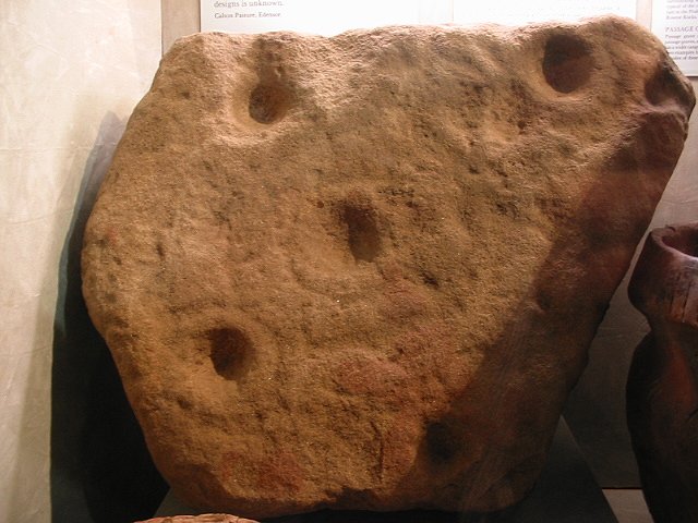
10/02. On display in Buxton Museum. This was unearthed on Calton Pastures.


There are 5 barrows along the pastures from the fort at Ball Cross to Rowsley; 4 on the pastue and 1 in forestry land.
They’re not overly impressive but not bad for Peak Barrows on improved land. Three barrows are now fenced off and because of that very overgrown.
Nothing special but it’s a plasant walk with good views across to Beeley Moor.

This round cairn visible from the Biggin Rd off the A515 Buxton-Ashbourne, has been much dug and a lot of the mound has gone. It covered a Neolithic single grave burial. The mound was also in use in the Bronze Age.
Thomas Bateman dug here and found a crouched skeleton in a cist made from limestone and many grave goods which included polished flint axe heads, a deer horn macehead and a small pottery flask.
The polished flint axe heads are on display in Sheffield Weston Park Museum.
This long barrow is approx. 40m long, it lies East/West with a round barrow on it’s Eastern end.
Longstone Moor itself is being quarried heavily, and the barrow lays in a field quite close to some old workings.
----------------------------------------------------------------------------
2006.
“close to some old workings” If only!
The White Rake is once again being worked...In fact the Peak Park Authority have signed much of Longstone Edge and the moor over to the quarry companies....What is one of the Peak’s most prominent limestone hills is, over the next few years, going to invert itself.

SK281696. Nice stone visible from quite a distance. Looks to be in the remains of a cairnfield.
There are 2 standing stones here located on the northern edge of a cairnfield; 1 stands about a metre in height the other, less than 1m away, about half this height. They both look to be kerbed. Another upright slab is also visible 30m away to the west and although probably natural the NMR says that it is likely to have formed a prominent feature of the cairnfield.


A square hill fort that was discovered in the late 1980’s. It is roughly 10 acres in size, protected on the North and South by natural slopes, a low banking can be seen on part of the North side. The Eastern Bank is very low with a wall running along it’s top. The Western bank also has a wall, but the banking here is more prominent.
Not a great deal to see, but Lathkil dale which the fort overlooks is well worth a walk along.

This is a tiny hillfort above Bakewell. Protected on two sides by steep natural slopes and a curved bank and ditch; enclosing an area of approximately 1.5 acres.
Excavations here unearthed several cup and ring marked boulders. These boulders pre-date the fort, one of them was used in the construction of the rampart. The stones are now in the Sheffield museum.
Room to park on the roadside above Ball Cross Farm.
...............................................................................
The nearby ‘Moatless Plantation’ was a meeting point (moot). There is an earthwork, of unknown date, surrounding the plantation
SK194633 – Bateman’s Tomb
Not really an antiquity as such, but Thomas Bateman dug over 200 barrows in the Peak District, sometimes up to 6 a day. He wrote two books on his works, ‘Vestiges of the Antiquities of Debyshire’ in 1848, followed in 1861 with ‘Ten Years Digging....’.
Some of his finds are displayed in the Sheffield and Buxton museums.
Inside the chapel the tomb lays behind, there used to be a carved marble memorial to Thomas Bateman....it is Now in Sheffield Museum. A strange thing to do with the grave and chapel still there.....I can imagine Batemans wry grin at the thought of it..


This is a corker.....
Down on the SMR as a barrow.....but it does look more like a stone/kerb circle with a central stone. Easy parking at the road junction, by the public footpath that leads below the stones, at SK954679.
Views to the North and East are very impressive.
In WP Witcutt’s 1942 contribution to ‘Folklore’; Fairies were said to dance and hold high revel on the barrow on Xmas Eve.
We bumped into a guy who lived on Cromlech Road who showed us the chamber.. he said something about cromlechs and dolmens and one of them has a ring of timbers around, thats how to tell the difference? something like that....
He had some ace pictures of down the Orme mine before you had to pay to go in.
Crazy guy whose breath smelt of windolene.......

This Iron Age hill fort isn’t far from the Bull Ring in DoveHoles and it’s definitely worth seeing.
After passing DoveHoles Railway Station there’s a single track turn on the left. After a couple of miles there’s a tall Chapel-en-le-Frith Parish sign, and room for a car. From here it’s a short steep climb up to the fort.
The ramparts and ditch are very impressive and the views are unbelievable. An Iron Age fort it underwent several changes to the fortifications and the stonework in the ramparts is still visible in parts. What a place....


These stones may be the stones the giant St Keverne threw at St Just for stealing from his drinking cup, there is debate as to whether these are the stones or the two stones on Crousa Common.
There are several other stories to do with this circle other than maidens being turned to stone for dancing on the sabbath. One story says that the place was the scene of a large battle between the Saxon Athelstan and Cornish Howell in 936AD, the site of the pipers is where the two men stood and directed their men on the battlefield.
Flint arrowheads found at nearby Boleigh were believed to be from a battle King Arthur fought for the Cornish.
First recorded in 1985 this stone is of uncertain status and could be a fairly recent rubbing post.


