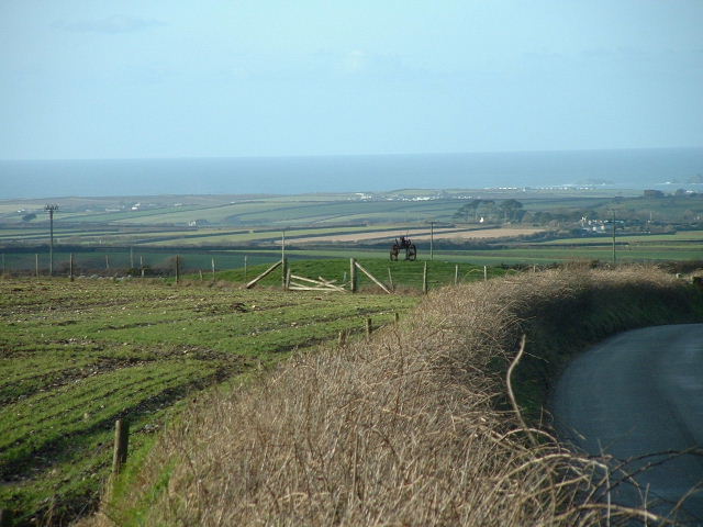
The ramparts at Castle an Dinas perfect for wearing out children.
80 )

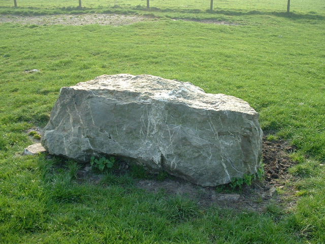
The stone in the fore ground is obviously a partner to the other that has now been covered. Both are touching the edge of the Bronze age barrow.

“brand new panoramic plate” erected by “Cornish Heritage” now totally obliterates the ancient stone that is associated with the barrow on the summit of Caste an Dinas.
To see the stone as it was...
themodernantiquarian.com/image.php?image_id=15532

This stone lies near the north barrow. It is a photo I took about 2 years ago. It is clearly something to do with the barrow. There is another stone about 8 feet away of a similar size.
You will not see this stone any more as “Cornish Heritage” have seen fit to place an information board on top of it.
The stone is not visible anymore!
news.bbc.co.uk/1/hi/england/norfolk/2994828.stm
A cluster of rare flint tools unearthed at Norwich City’s football ground could date back 12,000.
Archaeologists have found flint artefacts on the site of a new stand at the club’s Carrow Road ground.
Experts believe the tools could be from the Upper Palaeolithic era.
Archaeologists have found a sand island surrounded by peat which extends under the riverside ground.
David Adams, project manager from Norfolk Archaeological Unit, said the clusters of flint tools found in this area were left by Mesolithic people from around 10,000 years ago, but experts said they could be 12,000 years old, from 10,000 BC.
The tools were left by nomadic hunter-gatherers who would have used them to catch prey in the river valley such as reindeer when this glacial period was cold and harsh.
Mr Adams said the discoveries were rare, adding: “It’s a very exciting find. It’s older than we were hoping to find.
“Within Norfolk it is certainly very important and will probably be of national interest.”
The archaeologists stressed their six-week dig would be finishing two weeks ahead of schedule.
Situated in a farmyard sits this strange omega shaped stone 11 feet tall and partly worked by hand. It is mentioned by Cornish historian William Borlase and is said to be very similar to another stone on St. Mary’s on the Isle of Scilly.

The large gorse bush roughly marks the centre of the circle.
The mushrooms in the foreground seem to grow in abundance in the area!


Just enough room inside if you climb in backwards!


From the J.R.I.C.
Note on an unrecorded cromlech in North Cornwall
By Henry Dewey F.G.S. of H.M. Geological Survey
The Quoit/Cromlech lies about two and half miles s.e. of Boscastle and one and a half miles n.n.w. of Davidstow church. It is situated about half way between the farms of Treslay and Hendraburnick and stands in a field at the top of a hill which faces south. The top stone is large meusuring 16 feet by 8 feet and in places is 4 feet thick. A smaller stone not more than a quater this size supports at its western end, with some others nearly hidden by earth and shrubs beside it; while on the east the capstone rests on the ground, after the manner of the so called demi-dolmen at St. Breock Downs Beacon
Apparently these rock markings are best reached from the River Gannel by boat. There are not far from a place known as the Fern pit. This place is easy to find as there is a small ferry that operates from this point across to Crantock beach.
ps
The Gannel is tidal and a dangerous place to swim or wade, in order to walk right around the estuary you will need to avoid high tide.

from
Journal of the Royal institution of Cornwall Volume 10, page 190.

Groups of pits or hollows on sloping rock on the shore of the Gannel at “B” in the map Figures signify diameter in inches.
from
Journal of the Royal institution of Cornwall Volume 10, page 190.
circle of stones at the Kistvaen?
Borlase reported that the site had a small cairn around the site. John Barnatt reported in his book “Prehistoric Cornwall” that the nearby MenGurta also had a small cairn of quartz stones in a 2 metre radius around it. The Magi stone also close by, is reported by Borlase to have had “a small circle of stones on edge”

Men Gurta indicated in the distance. (About 150 yards)

Natural Formation?
I don’t think so!............
Only recently re-discovered near the Men gurta this “kistvaen” or entrance grave. It consists of two huge slabs of stone of a similar type to the nearby menhirs and the quoit at Pawton. I had seen it marked on some old maps but two separate books on local sites said it no longer existed!
First record by William Borlase in 1872 in his work Naenia Cornubiae.
He writes.....
“About 150 yards of the taller stone (Men Gurta) and upon equally high ground lies a flat stone of spar 9 feet 6 inches long by sis feet broad at its greatest breath resting on the ground at its northern edge and at its southern, diagonally upon a second stone 7 feet 6 inches long by 2 feet 6 inchesin breadth, and about the same in hieght above the ground. It has the appearance of an imperfectly form Kist-Vaen and therefore should pehaps have been inserted at a previous page.
A barrow of small stones from 30 to 40 feet in diameter lies around it, and a farmer mentioned the fact that an old man digging among them had once discovered something curious, but of what nature he could not remember. A small cairn also surrounded the adjacent monumentwhile barrows are scattered in abundance over the neighbouring downs.”
A footnote on the page
This species of monument is sometimes called an “earth-fast Cromlech” sometimes a “demi-dolmen” – Examples are not uncommon in Brittany and at Kerland bears a strong resemblance to the above.
The site is almost unchanged compare with the sketch in Borlase’s book although the area is slighty grown over. There is a trig point nearby, the site can be found slighty off the track that leads from the trig point if you walk to Men Gurta.
An exciting find and no Cornish guide book mentions it!
Also known as “The Dancers” or “Kiss-In-The-Ring”.
The circle is 16.5m across, with 26 stones
According to Paul Pettit in “Prehistoric Dartmoor” IBSN 0-9515274-6-0
Seventeen stones stand today, the two tallest about 4 and a half feet above the ground, one pillar and one slab. the stones are predominantly broad, but there are three distinct pillars and facing each of them on the opposite side of the circle is a broad slab. This appears to be comparable to the pairing of stones in many double rows. A cairn lies close to the circle , and about 170 yd to the south-east is the standing stone known as White Moor stone. No site on Dartmoor is moor mysterious and evocative.
According to Paul Pettit in “Prehistoric Dartmoor” IBSN 0-9515274-6-0
During World War II this monument was wrecked by troops traing on the moor. Today ONLY six stones stand to their full height . Four are fallen and broken; six are sad looking stumps, their tops deliberately knocked off and lying on the ground nearby. One substantial stone outside the circle remains a mystery. The magnificent site 1,450ft up can still be appreciated.
This is a large one (110ft diameter), but many stones are fallen.

Looking from Watergate bay towards Porth Island. You can also see the twin barrows on the cliff top.
At one time this stone could be seen from Nine maidens. When it was standing it was over 7 feet tall. It was knocked down and broken for use in road building in about 1870?


dsc.discovery.com/news/briefs/20030224/stonehenge.html
Discovery News
Stonehenge Up Close
Feb. 28, 2003 —The design of Stonehenge, the 4,800-year-old monument in southwestern England, was based on female sexual anatomy, according to a paper in the current Journal of the Royal Society of Medicine.
The theory could explain why the ancients constructed Stonehenge and similar monuments throughout the United Kingdom.
Anthony Perks, a professor emeritus of obstetrics and gynecology at the University of British Colombia in Vancouver, and a doctor at the university’s Women’s Hospital, first thought of Stonehenge’s connection to women after noticing how some of the stones were smooth, while others were left rough.
“It must have taken enormous effort to smooth the stones,” Perks, co-author of the journal paper, told Discovery News.
Thinking how estrogen causes a woman’s skin to be smoother than a man’s, the observation led Perks to further analyze the monument in anatomical terms.
He noticed how the inner stone trilithons were arranged in a more elliptical, or egg-shaped, pattern than a true circle. Comparing the layout with the shape of female sexual organs showed surprising parallels.
Perks believes the labia majora could be represented by the outer stone circle and possibly the outer mound, with the inner circle serving as the labia minora, the altar stone as the clitoris and the empty geometric center outlined by bluestones representing the birth canal.
In support of the theory, the body of a sacrificial child was found buried at the center of the circles at nearby Woodhenge, suggesting both monuments followed similar layouts. Perks even speculates a child’s body might lie buried at the center of Stonehenge.
Unlike other mounds in the U.K., very few burials are located around Stonehenge.
“I believe it was meant to be a place of life, not death,” said Perks, who thinks Stonehenge overall represents an Earth Mother goddess.
He explained that both western Neolithic cultures and the early Celts believed in such a goddess. Hundreds of figurines representing the idea of an Earth Mother, he said, have been found in Europe. They were created at a time when mortality at birth was high, suggesting Stonehenge could have been used for fertility ceremonies, which may have linked human birth to the birth of plants and animals upon which the people depended.
John David North, professor of philosophy emeritus at the University of Groningen in the Netherlands, outlines another theory in his book “Stonehenge: A New Interpretation of Prehistoric Man and the Cosmos.” North believes the stones in the monument have precise alignments to stars in the cosmos and that Stonehenge served as an astronomical observatory and a celestial map.
While Perks acknowledges the celestial link, he views it in a different light.
“At Stonehenge you see an arc of sky together with Earth on that open Salisbury Plain,” Perks said. “It is as though Father Sun is meeting Earth Mother in an equal way at a place looking towards the future.”
edp24.co.uk/content/News/story.asp?datetime=11+Feb+2003+20%
A new exhibition charting the incredible story of Norfolk’s Seahenge is set to hit the road this summer.
Archaeologists are putting together a travelling exhibition, focussing on the Iron Age monument’s discovery and its controversial removal from the beach at Holme, near Hunstanton.
Brian Ayers, Norfolk’s archaeology and environment officer, said it would be launched in Holme in May or June.
“It will be a mobile display we can take to other locations in North West Norfolk,” he added.
“It will be talking about the history of the excavation and what this has told us about the technology of that time.”
The timber circle, which was uncovered by the tides in early 1999, was hailed as one of the most important archaeological discoveries for decades.
But there were angry protests over the decision to remove the 4000-year-old relic from the beach.
The 55 timber posts which made up the circle and its central tree stump are currently being conserved at Flag Fen, near Peterborough.
When the preservation process is complete, in two years’ time, archaeologists hope it will be put on display somewhere along the stretch of coastline where it was found.
Axe marks gave new insights into the tools used during the period. Electronic scans showed 38 different axe heads were used to shape the timbers – at a time when metal technology had only just arrived on our shores.
The marks – believed to be the earliest tool marks found in Britain – show the society that inhabited the wild North West Norfolk coastline was far more advanced than was previously thought.

feb 2003
There are at least 3 tumuli at the top, you can see one in this pic if you look closely.


This photo is not a fake these boulder formations are very common in the area of Luxulyan.
Whilst driving towards Luxulyan from Lanivet this huge arse appeared over the hedge. After nearly crashing the car I stopped in a layby and stared in wonder......surely this was a place of worship?

Cornish newspaper “The Cornish Guardian” reported on 30 January 2003
A major archaeological project has been set in motion on Bodmin Moor ... over 150 years after the event which triggered it.
In 1837, workmen searching for stone to use in building unearthed the 3,000 year-old Rillaton Cup, which proved to be one of Cornwall’s most spectacular historic finds.
The solid gold object, standing just 8cm high, was found in a burial cairn near Minions. Underlining its significance, the cup was recently voted one of Britain’s top ten treasures by experts at the British Museum.
Interest in it was re-ignited by the discovery of a similar cup at Ringlemere in Kent a year ago.
Now the Cornwall Archaeological Unit, English Heritage and the British Museum are planning the first-ever comprehensive study of the site.
Jacky Nowakowski, a senior achaeologist with the Cornish unit, said the project was still being developed but had already created a lot of interest and excitement.
“What we want to do is study the whole of the landscape,” she said. “There are a lot of upstanding prehistoric remains in that area and the key thing we want to look at is the significance of the Rillaton barrow in relation to that landscape and how it has developed over time.”
The first phase of the project, which could start this summer, would involve an assessment of the landscape around Rillaton to identify potential excavation sites.
The next two years would see extensive fieldwork followed by a further two years of analysis resulting in the publication of findings.
One of the key sites, said Ms Nowakowski, was likely to be Stowe’s Hill, on which the naturally-formed Cheeswring stands.
“There are two neolothic enclosures, one smaller which is defined by stonework which is still visible, and one larger which contains the remains of roundhouses,” she said.
“What we hope to do is find dating evidence from those sites and try to understand the development of the area over the next 1,000 years in which we built the Hurlers ceremonial monument and the Rillaton burial monument.”
In a television programme aired on New Year’s Day, the cup was named as the tenth most important discovery ever made in Britain.
Made from a single piece of beaten gold, it was discovered by workmen in a stone-lined vault along with human remains, a sword, bronze dagger, glass beads and flint arrowheads.
It is thought the round-bottomed cup – a symbol of huge wealth and power – may have been made for a tribal chief or leader and then buried with them in the specially constructed barrow.
The online version of this article can be found at....
thisiscornwall.co.uk/displayNode.jsp?nodeId=85071&command=displayContent&sourceNode=85070&contentPK=3874915
Had no trouble finding these. Left the car in layby opposite the “Rocky valley gallery” and followed footpath signs down the valley crossed over a footbridge across a fast running stream. The carving were just behind the ruins of the old mills about 100 metres after the bridge. Also guided by strips of cloths and other rubbish hanging from the trees around the site. This spoilt an otherwise idlic setting.
Hanging of cloth is quite common at certain holy wells in Cornwall but I was surprised to see it here. There is no tradition on of healing wells or trees at this site perhaps visitors were influenced by displays of cloth on trees at the the nearby Witchcraft museum in Boscastle.
The sign at the site claims that the carvings Bronze-age but there is heavy debate that the carvings could have been carved by a “bored miller”. Perhaps they are ancient but more that one historian has pointed out the that work seems to have been carried out with a tool similiar to the ones used by millwright.
No other carvings of this type are found in Cornwall.
A site full of a mystery and well worth a visit. (Don’t let the miller theory put you off).