
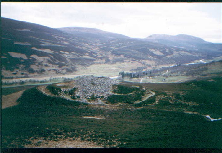
This mound, standing close to the base of Baile Mhargait hill, contains on its summit a beautifully preserved cist, complete with its displaced capstone.
Image credit: Les Hamilton
This mound, standing close to the base of Baile Mhargait hill, contains on its summit a beautifully preserved cist, complete with its displaced capstone.

This cist is found, open to the elements, on the very summit of the mound.
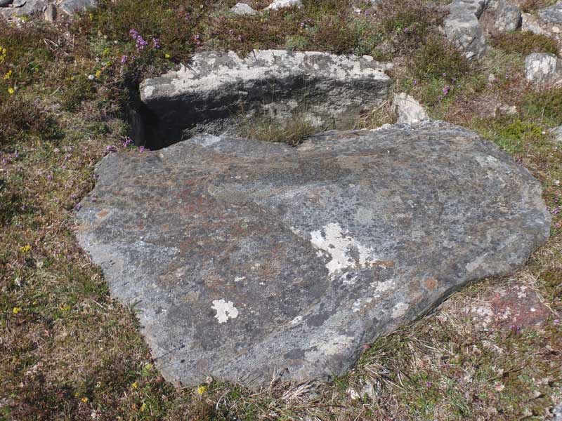
This is a view of the primary cist taken looking across its displaced capstone.

This cist, minus its capstone, lies just a few metres west of the main cist, on the flank of the mound.

This cist, which lacks both its capstone and end stones, lies about 25 metres northwest of the main cairn.
Visited: June 26, 2018
Canmore dramatically describes Dun Carnachaidh as: ‘The remains of a broch on a cliff overlooking the river valley’!
What cliff?
There’s no cliff within sight, and the broch stands just 90 metres west of the Strathnaver road up a steepish grassy hillside.
This broch cannot be seen from the road as it sits on a level shelf about 25 metres up the hillside. It takes but a few minutes to reach it. It is extremely ruinous with few major features extant. The foundation course can be followed intermittently around the structure and there are some impressively large stones of the 2nd course around the southeastern arc. Amongst the tumble to the west of the broch is what appears to be the remains of an intra-mural gallery.
Access to Dun Carnachaidh is straightforward as there is parking in a bay beside a cattle grid on the road just 1½ kilometres north of Carnachy. The fence at the roadside consists only of wire strands which it is easy to wriggle between (no barbed stuff).

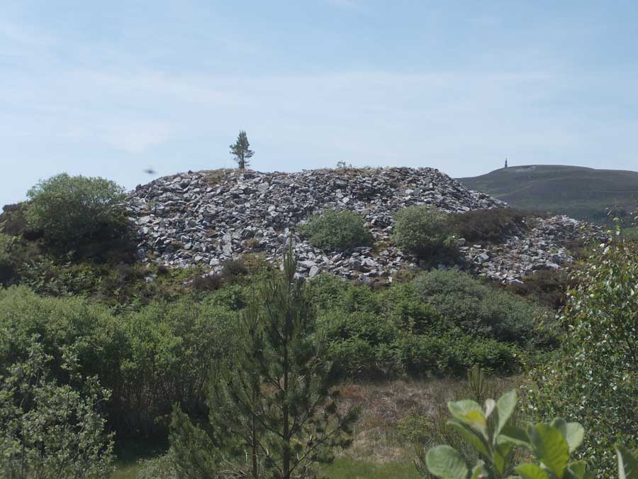
Dun Carnachaidh as viewed from the rise to the north of the broch.

This panoramic image illustrates just how dilapidated Dun Carnachaidh is nowadays.

These impressively large boulders are on the southeastern arc of the broch.

Dun Carnachaidh, still showing wall structure on its southwestern arc.


Amid the tumble of rocks to the west of Dun Carnachaidh is evidence of a possible intra-mural gallery.
Visited: June 25, 2018
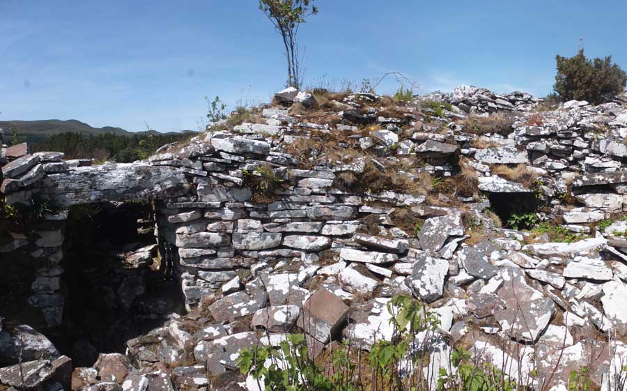
Located no more than 3 km west of the A9, and not far from the town of Golspie on the Dornoch Firth, Backies must rate as one of the ‘must see’ brochs of northern Scotland. Considered to be a solid-based broch, Backies was excavated in 1846, and the spoils simply tossed over its walls to form a stoneheap all around it. In this respect, its profile is almost identical to that of Carrol Broch. Backies stands on a steep rocky knoll just north of the community of the same name, and the only feature evident from outside is the 5 metre long entrance passage and the entrance portal itself, surmounted by a huge lintel.
But the interior is another matter altogether. The foundation course is completely buried in rubble but the second level is virtually complete and still stands 2½ metres tall round the entire structure with a well preserved ledge scarcement at 1.7 metres. The second level is hollow, and a well constructed doorway leads into the intra-mural cavity. A feature of the doorway is a lintel below the top which serves as part of the scarcement ledge.
Canmore states that:
“Backies is a good example of a once well preserved, hollow-walled broch which is steadily falling into ruin. Only its remoteness has preserved it from greater destruction, but there can be little doubt that in a few more decades all the surviving traces of hollow-wall architecture in Level 2 will have disappeared.”
There is a huge amount of information about Backies broch on the Canmore website.
To access Backies broch, look out for a sign indicating left to ‘Backies’ just a few hundred metres north of Golspie as you drive north on the A9, and mid-way between Golspie and Dunrobin Castle. Follow this road for 2½ km till you encounter a sign pointing right to a Scottish Water Treatment Works (marker ‘W’ on the map). There is room for one car to park on the verge just before this sign. Head up the road to the Treatment Works, where there is a possibility of parking just past their building on the right (marker ‘P’).
From the Treatment Works, walk up the road for 80 metres or so till you encounter a well constructed sinuous road heading to the right (east). The road ends at a ruined croft house in sight of Backies broch (yellow line). Although the terrain towards the broch (marker ‘B’) looks a bit of a jungle of woodland thickets and bracken there is a narrow footpath to it (though I missed it and had to fight my way round to the broch).
On the road’s final bend, just a few metres before the ruined croft house, a drainage culvert passes under the road. The path to the broch, which I only discovered on the way back from it, starts immediately before the culvert and heads in nearly a straight line to the broch (cyan line on map). In summer, it’s just a case of searching for the trampled path beneath the bracken and following it as best possible.
Visited: June 28, 2018
To visit this broch (which lies about 4½ km west of Kilphedir) park on the verge beside a large stone walled enclosure to the south of the road through the Strath of Helmsdale at NGR NC 945 188. The broch cannot be seen from the road, but it lies only about 100 metres uphill. Across the road, a path heads uphill towards a gate bearing a notice that this is part of the Suisgill Estate. Pass through the gate and follow the path uphill, looking to the right for the pile of rubble that signifies the remains of Balvalaich broch, and cut across to it.
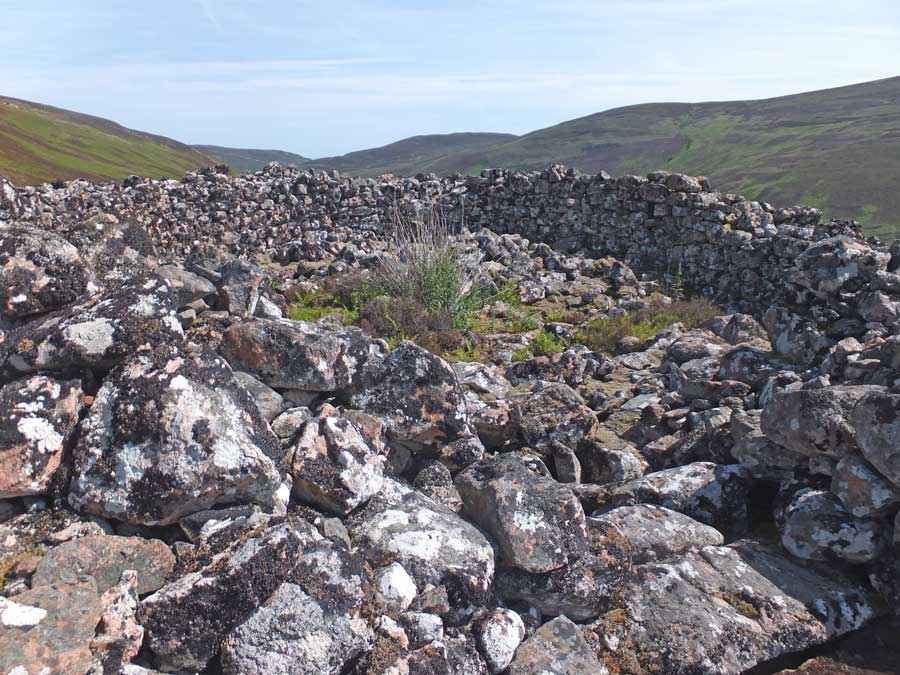
Balvalaich broch is severely denuded, having been quarried for stone when the original road was laid through the strath. All that remains in the interior is a wilderness of small stones. Nevertheless, both inner and outer wall faces can still be traced, with some particularly large foundation course stones surviving on both the southwest and eastern quadrants.

The ruins of Balvalaich broch sit in a splendid location in the Strath of Kildonan, overlooking the River Helmsdale.

This section of walling with its huge boulders, on the western side of Balvalaich Broch, is the first significant feature seen on approaching the structure.

Some of the large stones comprising the foundation level course on the eastern flank of the broch.

Though severely denuded, this section emphasises the original 4.5 metre width of the broch walls.

This is a composite of several photographs giving a panoramic overview of Balvalaich broch. The interior is simply a wilderness of small stones.

This is a view of Dun Viden tomb taken from the broch.

This is the view of the tomb’s heathery mound from the roadside with Dun Viden broch in the background.

This view illustrates the direction of the former chamber/passage.

The three standing stones probably represent former vertical chamber slabs.
Visited: June 28, 2018
When you visit Dun Viden broch you will undoubtedly also encounter the Orkney-Cromarty type Neolithic chambered cairn of the same name; in fact, you will most probably walk over it as you leave the path.
Visually, the site appears to be a set of large stones resting on the top of a heather-clad mound. These are residual chamber slabs from the severly robbed tomb. The small stones that once covered the cairn are long gone, and it is surmised that they may well have been used in the construction of the nearby broch.
Canmore adds that: ” ... the cairn has been removed and its edge cannot be traced, although the situation dictates that it could not have been more than 11 metres in diameter. The chamber has been about 3 metres wide and entered from the east”.
Visited: June 25, 2018
No journey up the Strath of Kildonan would be complete without inspecting the impressive remains of Kilphedir broch. Invisible from the roadside, the broch sits 90 metres up the hillside just east of the Allt Cille Pheadair (Kilphedir burn), and about four kilometres from Helmsdale. There is ample parking at the bridge over the burn, from where a rough land rover track leads uphill, soon revealing the broch as a huge pile of tumbled masonry perched on a knoll some 400 metres to the east. The broch is surrounded by outworks consisting of a deep ditch, an outer rampart wall over 3 metres wide, and an outer ditch, well illustrated by Greywether’s photograph.
The external wall face is completely hidden beneath tumbled masonry, the only feature remaining being the entrance passage on the northwest—almost five metres long—where three lintels remain in place. The interior on the other hand displays much of interest with walls four metres thick rising to eight courses around most of the structure’s circumference.
There is a doorway leading into an intra-mural passage where a stairway (no longer evident) was reported early in the 20th century.
You can learn much more about this broch by following this link to the Canmore website.
Visited: June 28, 2018
Dun Viden lies in Strathnaver, some ten kilometres south of Bettyhill and just 250 metres to the east of the River Naver. It can be reached by driving to the end of the metalled road to Skelpick, then walking an excellent (though rough in places) estate road for a further 4 km. As the broch comes into view, you will be aware of a number of standing stones just west of the road, the only surviving evidence of a Neolithic Tomb. At this point, cut across the heather to the broch.
The broch sits atop a grassy, twenty metre tall, conical knoll which slopes steeply down on all sides except the east. The structure has been severely robbed, almost certainly to aid construction of the Settlement (a so-called ‘Clearance Village’) that still stands immediately adjacent to the southeast of its knoll.
Although badly ruined, Dun Viden still has a recognisable entrance passage to its southeast, but most of the walling and interior have been reduced to a field of amorphous rubble. There are, however, a few places where large foundation level stones along the external wall face can still be seen.
Dun Viden must have been a great look-out point in its day; and remains so.


