
LesHamilton


Visited: June 26, 2018
June 2018 proved to be an exceptionally good time to visit Dun Creagach. Normally perched on a small island, and accessible only via a causeway of rough boulders, the drought had so lowered the waters of Loch Naver that I could actually walk completely round the broch on the dried-out loch bed without fear of getting a boot wet!.
Dun Creagach is huge and mighty impressive. Possibly because of its relatively remote location, stone-robbing does not seem to have been an issue here, as evidenced by the unusually large quantity of tumbled masonry that buries much of the broch’s outer walling: certainly there are no dykes or signs of former habitation—so often the prime reason for destructuring—anywhere nearby. Of course, over the centuries, Nature has taken her toll in the shape of vast heaps of tumbled stone, mainly outside the structure. Even so, the broch walls still tower to over three metres almost everywhere around its periphery, and everywhere, the outer face stands at least a metre above the surrounding tumble.
Despite the all-encompassing rubble, there is a lot to see in the interior of the broch. The largely blocked entrance passage with its massive inclined lintel, a large almost square doorway that leads into the intra-mural galleries, and several locations where gaps in the tumble suggest strongly a void within the walls. Indeed, Canmore states that Dun Creagach ”is certainly a true hollow-walled broch“.
Dun Creagach can most easily be accessed from Altnaharra, from a point just south of the village, walking up the road that heads to Klibreck Lodge. Just 50 metres south of this point, on the A836, is an enlarged passing place, where there is room to park several cars without compromising its use by road traffic.
The distance to the broch is almost exactly 4 km, the first 1.5 km on a metalled road as far as the Lodge. On reaching the Lodge, head right for a few meters then left round the building to a field gate and continue along a good dirt road that continues east. Two streams (marked ‘ford’ on the OS map) are actually now crossed by footbridges before the path peters out at the edge of a wooded plantation.
Now comes the tricky part: It is important to continue due east through woodland to a third stream. This is where I came unstuck, losing direction and heading away from Loch Naver. On reflection, I might have been better following the second stream to the shore, then continuing along the lochside to the broch.
In all, it took just an hour and a quarter to reach Dun Creagach, but underfoot conditions were particularly easy with the ground being parched: there were none of the usual bogs to negotiate.
This is a broch for the connaisseur, with much to see and enjoy. It takes more than the usual effort to make its acquaintance—a round trip on foot of some eight kilometres—but has so much to offer in return.

First sight of Dun Creagach, approaching along the shore of Loch Naver from Altnaharra.
Image credit: Les Hamilton

Dun Creagach from Loch Naver.
The variations in colour of the rocks below the broch clearly indicates how the drought has lowered the loch’s level, creating what looks like a tide mark around it.
Image credit: Les Hamilton

Dun Creagach is not currently an island.
The drought has lowered the level of Loch Naver by over half a metre, creating a shelf of dry land towards the shore of the loch.
Image credit: Les Hamilton


Neat courses of outer walling on the east of Dun Creagach.
Image credit: Les Hamilton

This composite panoramic photograph shows the interior of the broch viewed from the east.
Image credit: Les Hamilton

A section of the broch wall, hinting at the former presence of an intra-mural passage.
Image credit: Les Hamilton

This composite panoramic photograph shows the interior of Dun Creagach, looking north across Loch Naver.
Image credit: Les Hamilton
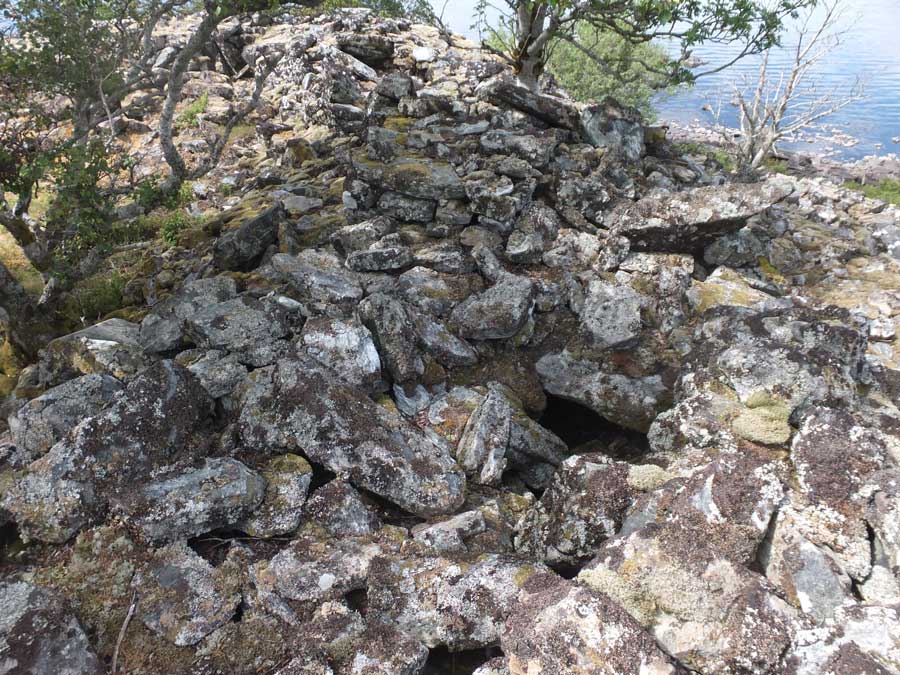
This image probably shows the broch’s second level.
A lintel to a probable gallery can be seen as well as a breach in the sidewall that hints strongly of a gallery within.
Image credit: Les Hamilton

This section of the internal wall contains a doorway into an intra-mural gallery.
Image credit: Les Hamilton

The fine entrance doorway to Dun Creagach, the actual passage now largely blocked by debris.
Image credit: Les Hamilton

This image highlights the impressively thick wall of the broch at the west of the structure.
Image credit: Les Hamilton

This is the impressive doorway in the south wall of Dun Creagach that leads to the intra-mural galleries.
Image credit: Les Hamilton
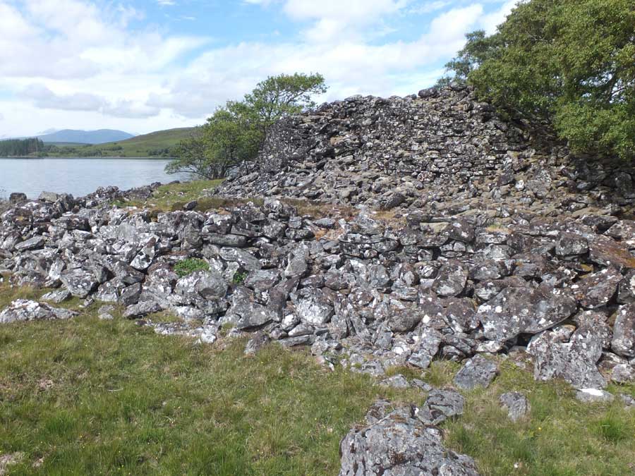
This elevated view from the east clearly shows the relation of the protective rocky wall (rampart) with the broch.
Image credit: Les Hamilton
Visited: May 2, 2018
Some 250 metres due north from the car-park opposite Trumpan Churchyard lie the remains of a small promontory fort called Sgoir Beag. From the car-park head northeast up the road for about 130 metres till you cross a stream then immediately enter the field on the left via the gate. Follow the stream which dives down to the sea immediately adjacent to the fort.
The grassy rise ahead quickly leads to a deep natural ditch which cuts off the dun from the east. Descent into the ditch is easy but the face of the dun rises much more steeply beyond. A well worn path to the left eases the climb to the top of the dun, overlooking the precipitous drop into the stream valley.
The surface of the dun is a grassy oval, with only a small fragment of walling, two courses high, showing at its nothern edge.

The promontory fort of Sgoir Beag, flanked by steep cliffs to north and west, and by a precipitous drop into a stream channel to the south.
Image credit: Les Hamilton

The prow of Sgoir Beag, viewed from across the stream to its south.
Image credit: Les Hamilton

On the landward side, Sgoir Beag is protected by a natural ditch, about 5 metres wide and 3 metres deep.
Image credit: Les Hamilton

Across the ditch, intermittent stonework peeks out from the side of the fort.
Image credit: Les Hamilton

Looking across the grassy interior of Sgoir Beag.
Image credit: Les Hamilton

This exposed section is the only remaining visible sign of walling courses on the summit of Sgoir Beag.
Image credit: Les Hamilton
Visited: May 2, 2018
Skye’s Waternish peninsula is best known for its three brochs: Dun Hallin, Dun Gearymore and Dun Borrafiach. But near the community of Geary on its eastern coast, unmarked on the OS map, lie the scant remains of Geary Promontory Fort.
Canmore’s notes from 1990 state:
This fort is situated on a small promontory on the precipitous cliffs towards the N end of the Geary crofts; it is defined by an arc of walling 4m thick and 0.75m in height that cuts across the promontory and line of the cliffs to the E, N and S providing protection on these flanks. At the S end the wall does not run up to the cliff edge, and although the N end is now wasted it can be traced up to the edge of the cliff.
At the time of my visit it was hard to believe that any defensive wall existed. But the location of the site was absolutely confirmed by GPS: I was definitely on the correct promontory.
The promontory is totally overgrown, in part by semi-mature thickets of shrubbery and elsewhere by rank grass and vegetation. I could find no coherent evidence of any protective wall: just a couple of large boulders, an earthfast moss-covered stone, and what appeared to be a thickly vegetated rampart which stretched across around a third of the neck of the promontory.
The only redeeming feature of this site is the views it gives across Loch Snizort to the Ascrib Islands, and northwards along the rugged Waternish coastline.
If visiting by car, parking places are non existent. However a helpful local told me to ‘just park in a lay-by’. As there is no through traffic in Geary, the temporary loss of one lay-by for parking is of no great consequence as everyone living there has parking on their properties.

The southern cliffs of the promontory atop which stand the scant remains of Geary Fort.
Image credit: Les Hamilton

From the fort’s interior, this heavily vegetated rampart is surely part of its original protective wall.
Image credit: Les Hamilton


The site of Geary Promontory Fort is thickly clothed with rank vegetation and thickets of shrubbery. Very little stonework is visible, save these two large boulders which may have belonged to its original defences.
Image credit: Les Hamilton

The wall that protected the fort is all but gone now. Perhaps these deeply embedded, moss covered stones are a relic of it.
Image credit: Les Hamilton

Overlooking steep cliffs, this is the view north from Geary Promontory Fort.
Image credit: Les Hamilton
Visited: April 29, 2018
About half a kilometre south of Flodigarry, on the A855, you pass Lochan nan Dunan, a small roadside lochan with a parking area beside it. Immediately on the right hand side of the road (if travelling north) is a heathery hillside rising steeply for about 15 metres. A stout barbed wire fence precludes immediate access opposite the parking area, but walking back down the road for 50 metres or so revals twin boulders arranged to form a stile.The fort of Lochan nan Dunan is revealed after making this short climb.
The fort comprises two enclosures, separated by a mighty rock stack twelve metres in height. There is little of real note to see although the grassy stumps of the enclosing wall of the eastern enclosure, little more than half a metre in height, can still be picked out. The western enclosure, located on a gentle slope, boasts an even less significant grass-grown wall.
The best part of the visit is the view it provides towards the mountainous backbone of the Trotternish peninsula. Particularly prominent is Sron Vourlinn, the gaunt flat topped hill to the northwest, and the Quiraing to the southwest.

The steep hill that conceals the fort from the roadside. Note the boulder-stile that allows easy access to the site.
Image credit: Les Hamilton

The eastern enclosure. All that remains is a low vegetated bank round its periphery.
Image credit: Les Hamilton

This composite photograph shows the western enclosure and the 12 metre tall rock stack that separates it from the eastern enclosure.
Image credit: Les Hamilton

The view from the western enclosure, looking northwest towards the flat topped Sron Vourlinn massif.
Image credit: Les Hamilton
Visited: April 29, 2018
Near the farthest northeast point of Skye’s Trotternish peninsula lies Kilmaluig Bay with its mighty Stac Lachlainn, a sea stac of truly immense proportions that towers above the clifftops. And immediately adjacent to the stac, to its northwest, is a small promontory on which stand the ruins of Skye’s northernmost fort, Dun Aird.
Like many if its ilk, little of the structure of Dun Aird has survived to the present day other than an obvious grassed bank to the west that is all that remains of its walls and a hint of facing stones on the approach to the crag from the gate in the fence. The interior is generally level and grassed over, sloping noticeably down towards the sea.
As with such eyries, the main pay-off comes with the views the dun affords, specially on a sunny day, when the shallow coastal waters of Kilmaluig Bay glisten with myriad hues. To the north the sea stretches off towards the North Pole, but the finest views are southward, towards Stac Lachlainn and the mountainous spine of the peninsula.
Access to the dun seems fraught by fences from all directions. There is certainly a coastal path skirting the bay, and though it is clearly well worn, it still requires the negotiation of at least three stout, gateless barbed wire fences. The other option is to take the metalled road up from the bay for a few hundred metres and then branch to the right past Aird House. This road ends at a gate that leads on to the moor. From here the dun and stac are due east, but again there are fences to negotiate (but no definite path to take – unless I missed it). Finally you arrive at the fence cordoning off the clifftops, which does, thankfully, offer an access gate immediately above the dun.
For the motorist, there is a car-park at Kilmaluig Bay.

Dun Aird viewed from the cliffs to its north.
Beyond rises the sea stack, Stac Lachlainn, and behind it, across the blue waters of Kilmaluig Bay, are the mountains of Trotternish (Sgurr Mor on the right and the pointy Sron Vourlinn).
Image credit: Les Hamilton


Dun Aird imaged from just inside the gate in the clifftop fence.
Image credit: Les Hamilton

The crag bearing Dun Aird seen from the clifftops.
Image credit: Les Hamilton

The remains of the entrance passage up into Dun Aird.
Image credit: Les Hamilton


This grassed over remnant of the walling course at Dun Aird is virtually all that now remains of its structure.
Image credit: Les Hamilton

This is the view north from Dun Aird, over the northern part of Kilmaluig Bay.
Image credit: Les Hamilton

This composite photograph illustrates the grassy, saucer-shaped interior of Dun Aird.
Image credit: Les Hamilton

This is the view to the south from Dun Aird.
The sea stack, Stac Lachlainn dominates the foreground, with the Trotternish mountains beyond, across Kilmaluig Bay.
Image credit: Les Hamilton

View from the south, featuring the splendid Stac Lachlainn. Dun Aird stands on the summit of the rise beyond the sea stack, at the left of the photograph.
Image credit: Les Hamilton
Visited: May 2, 2018
The rarely visited fort of Meall An Duna stands of a low, crag girt ridge west of Greshornish Hotel and some hundred metres from the shore of an attractive unnamed lochan. Little of the structure remains but the broad vegetated northern arc of its surrounding wall still stands around a metre in height with facing stones peeking out intermittently. At the east of the dun a level rising path leading to the summit might be the entrance passage. On reaching the fort, the reward for the intrepid adventurer is a wonderful view to the east, encompassing Loch Greshornish and the Trotternish mountains beyond.
From the end of the metalled road, just west of the Greshornish House Hotel, a dirt road heads west and curves northward for 250 metres towards a small stand of mature trees. Here, another path branches west through a gate, for about 180 metres, and through a second gate, till it meets a fence line heading due south. Just follow the west side of the fence for 250 metres and you arrive at the foot of the crag bearing the fort of Meall an Duna (marker ‘F’).