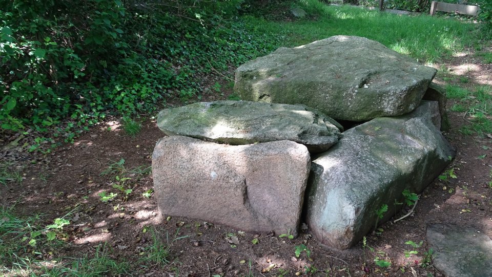


Hammah 3, like Hammah 2, is still buried in a mound with a length of around 21 meters and a width of 18 meters. The burial chamber resting in the mound is oriented approximately east-west. The chamber has a length of about 5.5 m and a width of 1.5 m. The chamber still has four pairs of support stones on the long sides and a closing stone on the western narrow side. These are all still in situ, the eastern capstone is missing. Sprockhoff recorded only two capstones in his plan of the tomb. On my visit, however, I counted five, one of them broken (as a result of an attempt to carry away the stones?).
The tomb is located in a small grove south of the Groß Sterneberger Straße. On this road you drive from Groß Sternberg to the east in the direction of Stade. Approximately 650 m behind Groß Sternberg a sign (N53° 37’ 54.5” E9° 23’ 32.6”) points to the right to the tombs (Hammah 2 and Hammah 3), here you should also park the car. You walk on the dirt road to the southwest, after about 500 m this track turns to the right and you reach a forest hut. Here you leave the main path and continue on the right side of the hut on the trail. Hammah 3 lies about 75 m along this trail, Hammah 2 is only about 40 m further on the same trail.
Visited May 2019


A closer look at the passage entrance on the left
Visited May 2019


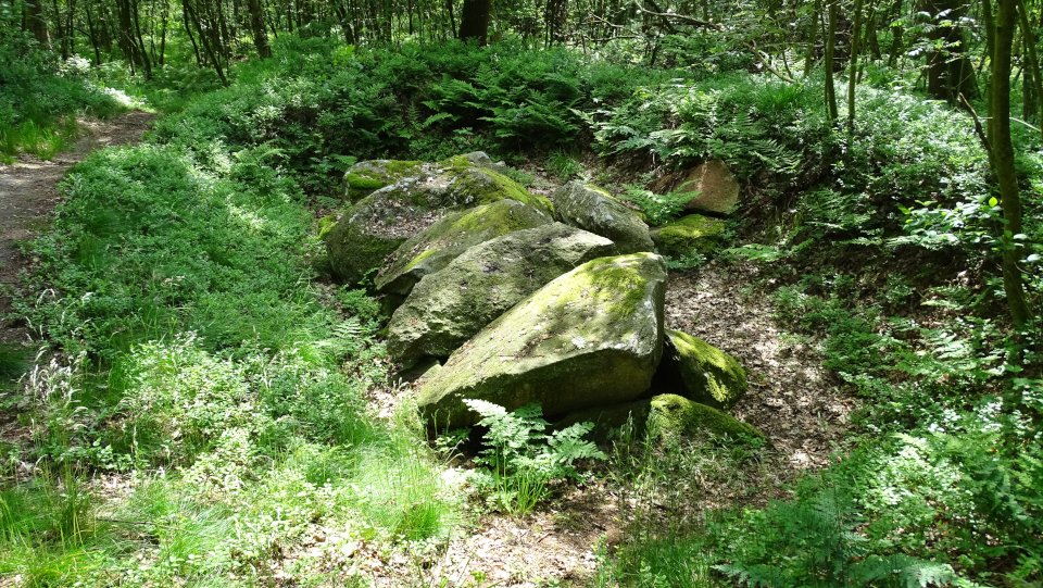
Hammah 1 is a very well preserved passage grave consisting of ten support stones with the associated intermediate lining of dry masonry and three large capstones. The hill, which once covered the tomb, is still clearly visible. The tomb is located in a small clearing under an idyllic group of trees, only about 40 meters from the road.
Drive on the K3 northward from Hammah to Groß Sterneberg. Just before you reach Groß Sterneberg there is a small group of trees on the right side, the tomb is located under the trees. Parking is a bit tricky, but possible on a access into the surrounding fields.
This is a stunning beauty and must-see site, if you are in the area!
Visited May 2019
taken from the on-site information board:
The megalithic tomb of Hammah
The more than 4000 years old megalithic tomb of Hammah is one of the best preserved Neolithic tombs in the district of Stade. The faithful preservation of the stone chamber is due to the Groß Sterneberger teacher Wilhelmi, who saved the grave after the First World War from being used as a source of raw material for a memorial monument. In 1924 the district of Stade leased the site of the megalithic tomb with an area of ??1100 square meters and bought the area in 1969. It is not without pride that the Hammah community keeps the megalithic tomb symbol in its local coat of arms.
In August 1921, Prof. dr. K. H. Jacob-Friesen archaeologically examined the burial chamber and published in 1924 the obtained excavation results. The tomb has been erected on a flat top of a hill. The carrier inventions are recessed in the sandy soil; their glacier-polished smooth sides point inwards. ‘Lining bricks’ closed the gaps between the support stones. Up to the upper edge of the support stones a sand hill has been heaped up; the resulting inclined plane has facilitated the application of the capstones. In 1968, as part of a restoration, Dr. J. Deichmüller gained further insights: a gravel of beaten granites and rolling stones surrounded the burial chamber as an abutment within a radius of 2 m and to a depth of 2.25 m (measured from the top of the middle capstone); the ground inside the tomb was paved with a larger debris.
In 1921, the excavators found outside the burial chamber an urn burial of the pre-Roman Iron Age at one of the supporting stones. The chamber contained only Bronze Age inventory: 7 shards of an ornate ceramic vessel, an ornate bronze arm ring preserved in fragments and also some cremated bones. The excavators concluded that Bronze Age people had cleared out the remains of the Neolithic primary burials, along with grave goods, before using the chamber to funnel one of their group members.
Scientific investigations by Dr. Leuschner and Dr. Delorme have revealed that around 350 AD, Hammah began to build up bogs, which eventually led to a complete overmooring of the Neolithic and Bronze Age tombs. The bog saved the tombs from access by people seeking building materials for roads and house foundations. Only by the extensive cultivation of the moor at the beginning of this century, the originally 3-4 m thick upland moor was drained and dug.
As part of the research project on landscape development and settlement history in the Stader area in 1983, the eastern edge of the hill of the megalithic tomb and some Bronze Age burial mounds were archaeologically examined. The results were submitted in 1985/86 in the series of the district Stade “Beiträge des Landkreises zu regionalen Themen” (“Contributions of the district to regional topics”).
The four megalithic tombs are located in the area of ??the municipality of Hammah belonging to the integrated municipality Oldendorf-Himmelpforten in the Elbe-Weser triangle in Lower Saxony in a former bog. During the draining and cultivating of the bog during the First World War, the stones of several tombs, which had originally been erected on a flat, sandy hilltop, on which the moor formation started later, unexpectedly came to light. The four tombs are part of a larger necropolis that stretches northeast of Hammah in the northwest-southeastern line.
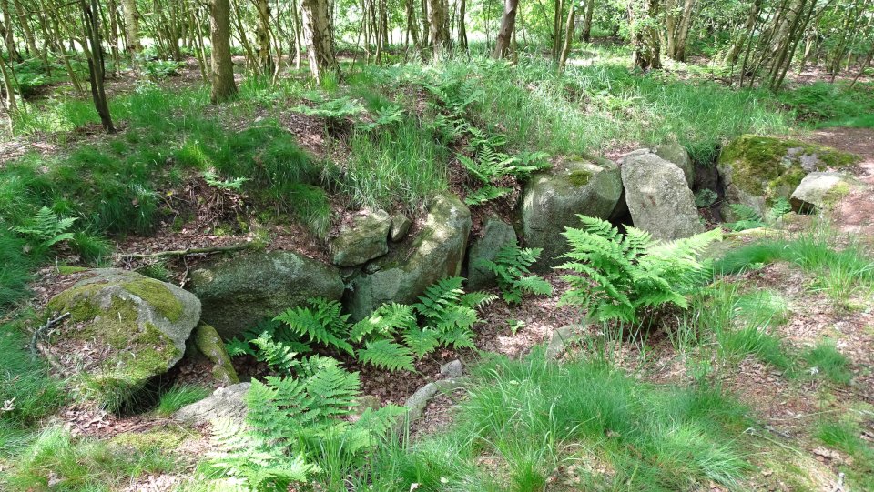
Hammah 1 is located near the belonging to Hammah district Groß Sterneberg immediately east of the two places connecting Bahnhofstrasse. 1.1 km east-southeast of this are the tombs Hammah 2 and Hammah 3 at the southeastern end of the necropolis. They are only 20 meters north-south from each other. There are also two burial mounds at this site. Hammah 4 is about halfway between Hammah 1 and the tombs of Hammah 2 and Hammah 3.
Visited May 2019


Unfortunately there is not much left of the megalithic tomb in Heinbockel. Only two supporting stones, as well as a capstone and a end stone of a northeast-southwest oriented burial chamber is preserved. Its width is 1.5 m, the original length and the type of the tomb can not be determined. The information board makes like the entire system a rather sad impression. The proximity to homes and a road also does not contribute to the overall atmosphere.
The tomb is located directly in Heinbockel. Drive on the K57 from Hagenah towards Heinbockel. Just when you enter the village turn right into the road Im Buschberge, which leads directly to the tomb. After 300 m you come to a T-junction and the road Kötnerende, the tomb is located directly at this T-junction on the other side of the road.
Visited May 2019
taken from the on-site information board:
The megalithic tomb of Heinbockel
Only one end stone, two opposite support stones and a capstone testify to a megalithic tomb from the Neolithic (the younger Stone Age) in Heinbockel. The accompanying drawing illustrates the general principle according to which megalithic tombs have been erected: The longitudinal sides of the burial chambers are formed by paired boulders, the conclusion on the narrow sides is formed by a eratic block. The capstones rest on the stones.
Over the centuries, the megalithic tombs were largely destroyed because their stones were sought after for construction purposes. An impressive example of such a changeable tomb-to-quarry history is this remnant of a megalithic tomb. It is a monument in the double sense. On the one hand, it bears witness to a type of burial in the Neolithic period, on the other hand, the handling of later generations with these graves. (One of the best-preserved megalithic tombs in the district of Stade stands on the road from Hamburg to Groß Sternberg.)


The Bronze Age stone cist of Hagenah is located southeast of the cemetery of Hagenah on the street “Krügerfeld” in a field. Parking is easy at the cemetery. Access should be possible all year round, as a small trail leads to the group of trees under which the stone cist lies.
The commonly known “Osterbarg” hill, which covered the stone cist, belongs to a destroyed group of burial mounds on the Geest ridge. After the First World War, the Osterbarg was gradually removed. In doing so, a tree coffin stone packing of about 2.5 m to 3.5 m was destroyed. At the end of 1930, one came upon a vertical stone slab, which was part of the stone cist. In 1964 the box was completely uncovered and is nearly in a perfect condition. Most of the cist is covered by a large capstone.
The monument stands today under high trees at a far visible place.
Visited May 2019
taken from the on-site information board:
The stone cist tomb of Hagenah
The stone cist tomb of Hagenah belongs to a group of ruined burial mounds, which lay on a Geest ridge beside the valley of Schwingetal. Once the tomb rested under the southeastern edge of a mighty mound of about 26 meters in length, 22 meters wide and 1.80 m -2 meters high. Due to frequent sand removal this mound was mostly destroyed. According to reports, a 2.5 m x 3.5 m large stone packing was removed before 1930, the stone cist was discovered at the southeast end of the mound remnant. Only after finds from the burial chamber came to light, the then monument conservator in Stade, Adolf Cassau, was notified. To preserve the remains of the mound, he examined only the interior of the stone cist. He was supported by archeology doctoral candidate Karl Kersten from Stade, who later became widely known as a prehistorian. From the excavation findings and the reports of the sand-mining worker, the picture of a completely paved chamber resulted, in which probably two burials were made: A body burial and a burial of cremated bones are considered secured. The brozen grave goods, a so-called northern palstave, a two-part fibula and a dagger were assigned to the body burial (see found drawings and image of the finds on this board). The axe and the fibula belong to the period II of the Nordic Bronze Age after Montelius (some 1500 – 1250 BC).
The state of preservation of the monument required in 1964 an archaeological follow-up. Dr. J. Deichmüller uncovered the stone cist completely, so that its structure could be completely clarified: Two narrow, long support stones border the long side of the chamber. A larger and a second smaller support stone are on the western narrow side; on the eastern narrow side is a “closing stone”. A large capstone lies on the western chamber, a smaller cap covers the eastern third of the chamber. Several small stones close the gap between the two capstones. Very carefully, the joints between the support stones and capstones have been closed with hewn stones. Wedge stones provide good stability to the support stones embedded in the ground.
The History and Home Association of Stade has acquired the property with the stone cist to ensure the protection of this cultural monument from the older Bronze Age.
Byhusen is a megalithic tomb preserved only in remnants. The tomb is located southeast of Byhusen about halfway to Farven on the edge of a field. At the border of two fields several boulders lie in a hedge on a distance of about 50 m, which are probably the remains of a megalithic tomb. It may be the enclosure stones of a giant bed (Hunebed / Hünebett). According to Johannes Heinrich Müller and Jacobus Reimers, it was almost completely destroyed in the 1890s.
Driven on the K127 from Byhusen towards Farven. Turn right after a cemetry, just before you leave the village. This roads leads first through a forest, before it reach an open field. Continue until you come to a T-crossing (about 1 km after you leave the K127), turn left here. The remains of the tomb lies 75 m in the hedge on the right.
To be honest not much to see, maybe a visit in winter is the better choice.
Visited May 2019