


Don’t know if this mess also belongs to the destroyed tomb
Visited May 2019
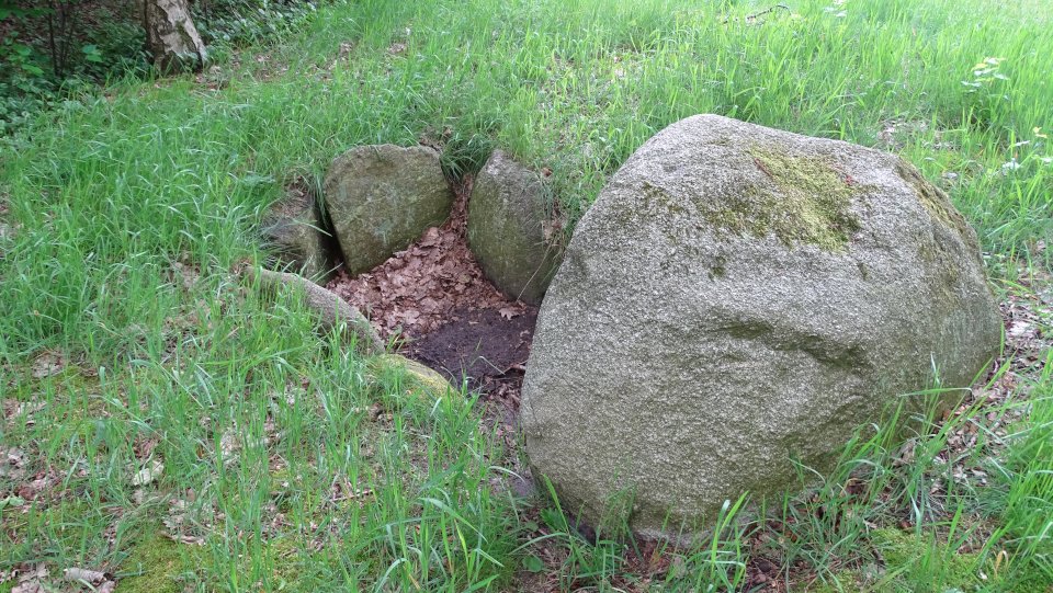
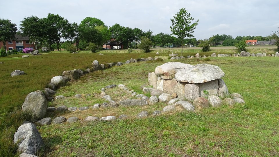
This is a rather big stone cist from the late neolithic, constisting of 4 support stone pairs, two end stones and one big capstone. According to the information board, the stone cist was relocated from the western field, the original position was about 30.0 m southwest in the field.
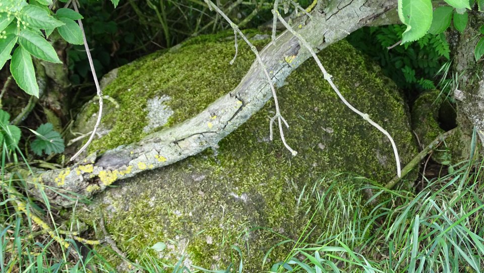
Also two larger boulder are laying north of the stone cist, which are probably stones from now destroyed megealithic tombs from the same field.
In Fehrenbruch take the Fehrenbrucher Mühlenweg which leads to the west-northwest. Continue for about 1.2 km, passing a cemetry and you’ll find the stone cist, along with an information board and a parking possibility, on the left side.
Visited May 2019
StoneExperienceRoute (Station 35)
Stone graves and Barrows Fehrenbruch
The burial cemetery in Fehrenbruch
In Fehrenbruch are still the remains of a large prehistoric cemetery, which gives the visitor an impression of the burial culture of the Neolithic until the early Iron Age. There are different graves of the respective epochs. At least three giant tombs, also called megalithic tombs, were buried in the area adjoining to the west, where the dead of a family were buried for many generations. These graves were built from partly huge boulders and were usually superimposed with up to 1.50 m high mounds.
Surrounding boulders are undoubtedly wall stones of such tombs of the Neolithic. The construction of such graves made of huge stones, which seems puzzling to us today, testifies on the one hand to the high degree of craftsmanship, but on the other hand also strengthens the popular belief that only giants could move such large stones.
The small stone cist from the Neolithic period for one person is unfortunately no longer available in the original condition. A reconstruction is located northeast of the original location. From the later Neolithic and older Bronze Age (2500-1200 BC) are the mounds of burial mounds. They originally had steep outer walls made of stones or grass sods and a higher domed summit. The dead were often buried in coffins of hollowed-out tree trunks.
Small shallow burial mounds over urn graves of the younger Bronze Age and Early Iron Age (1200-700 BC) have also been found here.
The act of giants
Even in the Middle Ages, it was believed that the Neolithic tombs, lined with tons of stones, could only have been built by giants for their own kind. The still common name “giant tomb” seems to take into account the creation of this legend, because a “Hune or Hüne” is by definition a superhuman and strong being, just a giant.


These two large stones lying near the stone cist are probably relocated stones of now destroyed 2-3 megalithic tombs, which lied 100 m west of the cist.
Visited May 2019


above: Bronze age stone cist
below: Neolithic megalithic tomb
Visited May 2019
The stone cist of Anderlingen is the most famous stone cist of Germany, which was created about 3,400 years ago in the older Bronze Age. It was found in 1907 in a hill near Anderlingen and is now in the Lower Saxony State Museum in Hanover.
About one kilometer northeast of Anderlingen there were three burial mounds. In 1907, when they wanted to remove the middle grave mound to gain building material, they came across the stone cist.
At the site of the middle burial mound, the Anderlinger Kulturverein reconstructed the various graves as well as the burial mound. The reconstructed stone cist contains only a replica of the original picture stone, which is also Lower Saxony State Museum in Hanover.
Drive from Anderlingen on the K109 to Sprakel and at the first opportunity turn right into the street Wiesenweg. The nicely reconstructed complex is then located after about 375 m on the left side.
Visited May 2019
taken from the two on-site information boards:
The burial mound with picture stone of Anderlingen
Discovery
In September / October 1907, a burial mound was dug in Anderlingen to gain building material. Gerdt Hinrich Brandt came across a stone box.
The stone box was then exposed to rain and snow for several weeks. As a result, over time, the adhering sand was washed away from the stones. Thus, in January 1908, the depiction of several persons on the southern end stone became visible.
After the discovery of the picture stone the provincial museum Hanover (today’s federal state museum) initiated immediately excavations under the direction of Dr. Hans Hahne. Due to the frosty weather, only the stone cist and a small part of the surrounding area could be examined.
Burial mound
The burial mound was created in the Bronze Age between 1,700 and 1,400 BC. In the middle was a stone packing that served as a foundation for a tree coffin.
In the period between 1,400 and 1,500 BC, the mound was extended for two secondary burials. The stone cist with picture stone and a stone pavement was created, which probably served as a base for another tree coffin.
Some time later the mound was opened by grave robbers who deliberately visited the stone box.
Finds
Already in October 1907, the local historian Hans Müller-Brauel was notified of the find. He was able to secure a hatchet, a fibula (garment clasp) and a dagger (all made of bronze) from the stone cist. The wooden handle of the dagger decorated with bronze studs was still recognizable. But only the rivets could be recovered. Remains of leather-covered wood sheath were also still present. Other additions of organic material such as textiles or wood have not survived. On the stone cist some ceramic disks could be observed.
From the central stone packing only a tiny bronze fragment was recovered.
Picture stone
The most famous find is certainly the picture stone. It shows three persons. The left one raises his hands in praying posture, the middle one carries a hatchet and the right one is characterized by a long robe and an oblong-oval head.
Figurative representations within graves are only known from the Swedish sites Kivik and Sagaholm. Comparable figures are also found in the rock drawings in Bohuslän, Sweden. Presumably, a funerary ceremony or a mythical scene is depicted on the picture stone of Anderlingen.
Burials
During the first work on the burial mound in 1907 and in the excavations in 1908 several burials were observed, which were much younger than the Bronze Age.
A rich woman’s grave was in the upper part of the grave mound. The dead was buried in the late 5th century AD with three gold-plated silver fibulae. Two brooches had a distinctive bird shape and were made in a Saxon workshop according to Franconian model.
In a neighboring hill was the richly decorated tomb of a Saxon warrior of the 5th century AD, who once served in the Roman legion.
Surrounding Area
Formerly there was a small group of altogether three burial mounds, presumably all from the Bronze Age.
Reconstruction
A reconstruction of the burial mound was built, as the picture stone of Anderlingen is one of the most important and well-known archaeological finds in northern Germany. It clarifies the Europe-wide relations during the Bronze Age.
The grave buildings were reconstructed on the former site. A newly raised mound gives an impression of the former appearance of the burial mound.


A view from the newly raised burial mound towards the old location of the mound with the cist
Visited May 2019

A replica of the Picture Stone inside the cist
Visited May 2019

The reconstructed burial mound from the south
Visited May 2019

The reconstructed burial mound from the north
Visited May 2019


The tomb is located northwest of Gnarrenburg and west of the district Brillit in the forest Hegebusch close to the municipal boundary to Basdahl. Apart from the GPS coordinates, a picture and the indication that at least four stones lying in a row, some deep in the earth, probably capstones would be recognizable, unfortunately there is no further information about this tomb on the German Wikipedia website. Therefore, I am not sure if I have really found the actual tomb, as the stones shown are located about 40m further north of the Wikipedia coordinates given on Wikipedia. In addition, the forest floor is now overgrown, so that the stones stand out only slightly from the vegetation.
To visit the site, you must have a GPS-device, as it lies in the woods and is not recognizable until you stand in front of it. Drive on the B74 from Kuhstedt north towards Brillit. Around 580 m after the forest ends on the left and right side, turn left into the Hegebuschstraße and continue until the road ends. Park here and wald straight on towards the forest on a field track. The tracks first make a zigzag (first left, then right and then again left). After another 450 m you reach a T-junction on a larger forest road, turn right here. Walk for about 200 m before you turn left into the woods, from here you must use the GPS device.
One warning: during my visit the grass on the field track was very high and I caught several ticks. So this is only for real enthusiasts and/or completists. Also a visit during winter might be the better choice.
Visited May 2019


The megaltihic tomb lies north of Gnarrenburg in a pine forest, not far from the forest road that leads from Gnarrenburg to the district Brillit. Already in 1893 the grave was considered considerably damaged. Later, two more larger stones were removed. The site, which was examined by Jürgen Deichmüller in 1968, was restored, but it was not possible to determine the type (passage grave or grand dolmen). The chamber is south-west-northeast orientated, the partly quite small support stones are still in situ. At the eastern end of the chamber is a capstone, but all other capstones are missing. At the western end the burial mound is still clearly visible.
Drive from Karlshöfen on the L122 towards Gnarrenburg. Just before you cross a railway line turn right into the road Barkhausen. Drive around 1.8 km before you turn left into the road “Am Kirchendamm”. Drive along this road for about 2.1 km, there is a very small parking lot and a forest track on the right side. During my visit, there was also a noticeable sign for the tomb. Park here and walk around 200 m along the forest track eastward, until you reach a beaten path leading in the wood on the left (also signed). The tomb is then only 50 m into the wood.
Visited May 2019
taken from the on-site information board:
Remains of a megalithic tomb from the Neolithic
The burial chambers of large boulders were built in the Neolithic funnel beaker culture (about 2500 – 2000 BC). They probably served individual families as crypts or ossuaries.
Findings from the tombs such as flint axes, arrowheads and clay pots are interpreted as funerary objects. This burial chamber contained shards of at least 24 decorated clay pots. The occurrence of many potsherds next to the stone chambers, mainly on the south side in the passage and outside the hill, point to rituals of funerary worship or ancestor worship, which we can not explain yet.
Following the burials of the funnel beaker culture, as in many other stone graves, there were burials with grave goods of the younger single grave culture. They show that the descendants of the builders have adopted the material culture of an immigrant population, for whom individual graves under burial mounds are characteristic.


Ostereistedt is an approximately northeast-southwest-oriented megalithic tomb whose comparatively long and thereby narrow chamber originally had probably seven capstones. Only two of them have been preserved, both of them no longer in their original position. A capstone lies rolled on the northeastern end of the chamber, a second has fallen into the chamber. From the chamber are still four supporting stones of the northwest and five of the southeast long side and the northeast capstone preserved in situ. The entrance was in the middle of the southeastern long side. Around the chamber are some stones that are probably remnants of a destroyed enclosure.
The tomb is difficult to find, even with a GPS device. Drive on the L122 from Ostereistedt towards Rhadereistedt. Before you leave the village turn left in the Bahnhofstraße. Drive through Wennebostel and cross a railway line. I parked approximately 360 m after crossing the railway line (N53° 17’ 31.0” E9° 09’ 29.3”), where a forest track leads to the right. From here, the tomb is about 450m northwest as the crow flies. So first take this forest track for about 200 m, before reaching a slightly overgrown path that leads in a slight arc to the northwest. After about 300 m you should see the tomb in the wood.
Visited May 2019
taken from the on-site information board:
Remains of a megalithic tomb from the Neolithic (approx. 2,250 BC)
Originally thick boulders lay as capstones over the burial chamber. A dry masonry of broken granite stones filled all the gaps. A layer of clay and mounds covered the grounds. On the south side a passage led into the tomb.
The stone tombs are tombs of the first peasant population. At the same time the cultivation of various cereals, other crops and livestock begins. Also larger stone axes were made, which enabled the felling of trees for large houses. Excavated floor plans of various post structures give us an idea of the type and size of the houses.