drewbhoy

drewbhoy

All posts expand_more 12,401-12,450 of 13,340 posts

Hill of Barra

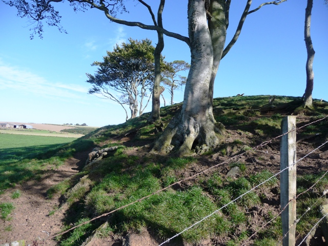
The community of Bourtie have a path that leads to the summit of the Hill Of Barra. I parked beside the old kirk and made my way thru various stiles and fields to reach the the summit. A walk of about 800 meters. This walk isn’t so popular as the Oldmeldrum (the Blankets) side, but I would advise it’s use, the stone circles at Bourtie and Shieldon are close by as well as the ring cairn on the Hill Of Selbie.

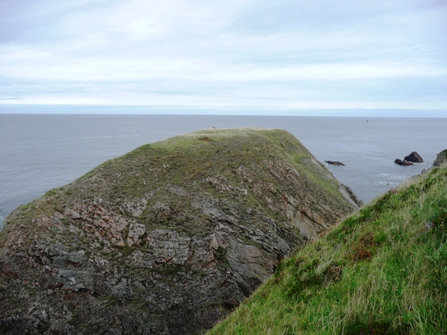
This was a well positioned fort with truly tremendous views over the Garioch area of Grampian. This path approaches from a south easterly direction, the first views being the three ramparts and the entrance. Nature did it’s job for the northern defences. Within the fort is Wallaces Stone. Robert the Bruce used it as a base to subjue the Earl of Buchan. Check the 1308 site. Why don’t they teach this stuff in schools?

As is usual up here the weather changed instantly and the customary drenching happened on the way down. Don’t let that stop you from coming here as this is the heart of rural Aberdeenshire. So a good starting point for anybody’s adventures!

Visted 3/10/09.

Wallace Stone

This stone can be found in the middle of Barra Hillfort and is a handy shelter. The picture shows the views over to Oldmeldrum.

Visited 3/10/09.

Folklore

Wallace Stone
Natural Rock Feature

Legend has it that William Wallace, the legendary Scottish freedom fighter, picked up this stone and flung it at Robert The Bruce, the Scottish King. Wallace believed that the Bruce had killed to much men in the North East and in anger heaved this at the King. One problem--Wallace wasn’t even here. Nice story though.

Another legend tells of the story that the giant Jock O Bennachie had caught the Tap O Noth wooing one of his girlfriends. In anger this stone was flung, in completely the wrong direction, as the Tap O Noth is northwards, Barra is to the east. Thank goodness he didn’t play darts as the Grenago Stone at Oldmeldrum is reported to be another bad aim.

From Barra 1308.

Greenlands

There are many hut circles and little cairns in these woods near Kintore. This must have been a sizeable community. There could be up 20 huts here. The entrances all face south. Unfortunately forestry has taken over and many have been ruined or destroyed, some been run over by huge logging machines. I only found four but will return to find the rest.

I parked at the forestry commission track opposite the entrance to Greenlands farm. Good boots needed, this is ankle breaker country. Plenty of wildlife to see as well. After Hatton Of Fintray on the B977, leaving from Dyce, take the road north to Inverurie.

Visited 3/10/09.

Woodside

This site has caused confusion for a long time in the town and amongst the people who take an interest in ancient things. Pub conservations often have an element of truth and in this case was proved correct. A ring cairn does exist at Woodside but this isn’t it, Canmores one is possibly 1/4 mile thru the woods to the west. Only running short of time, rain and dodgy footwear prevented further search for it. But I know where it hides.

Mrs. Shand kindly gave directions, she stays at Woodside farm, to both is interested in local history also explained many things. This ring cairn has no stones left but the cairn can be seen and the middle is hollowed out in a circular shape. But kerbs have been here possibly white quartz as a nearby pile proves. The inner kerb is about 10 feet in diameter, the outer being over double that. The height of cairn between kerbs is about three feet and is tree covered. Some damage has been done to northern side by a tractor. Unfortunately my photographic skills aren’t up to much so anybody wanting to do the place justice can get in contact thru the normal means. As for me I’m away to find the other ring.

Just to add to the confusion there is mean’t to be a stone circle near Delgatie Castle, fustrating cause I worked there some time ago. Add in a barrow and yet another cairn and the search becomes even better. Even more annoying they are all less than a mile from my front door!

From Turriff head north on the A947 towards Banff. Take first road heading east marked Delgaty and Cuminestown. Woodside farm is the first farm on the left at the end of the road. I asked permission to have a look round which was kindly given. Follow the track, east, behind the house until it’s end. Behind the cairn is the boundary fence. I was warned about the Highland Cattle but they seemed quite happy resting in the watery sun. Only a 1/4 mile walk but wear wellies!

Visited 30/9/09.

Mill Of Fisherie

The northern side of this cairn is pretty well covered in grass with very little erosion. However on the south side the erosion is spectacular and probably man and animal made. Godsman makes mention of the cairn in his book as well as the Law Of Balgreen and the stone circles at Clochforbie and Auchnagorth, although the OS omit it from their maps. According to the farmer one kerb remains of the Bronze Age cairn. Sad and inspiring at the same time this cairn will gradually erode away, at least the photos will prove it existed.

From Macduff travel east towards Fraserburgh on the A98, turning south at the Pitgair signpost. Follow this road until it ends at Fisherie, turning left. The Mill Of Fisherie is signposted a further 200 yards along the road with the cairn clearly visible.

Visited 26/9/09.

Miscellaneous

Mill Of Fisherie
Cairn(s)

This cairn is mentioned in the James Godsman 1952 book King Edward – Aberdeenshire. The Story Of A Parish. There is a photograph of cairn when it wasn’t so badly eroded.

Comfort Law

This at some stage must have been a massive stone cairn, now only a small pile remains. There are loads of dry stane dykes in the area and its easy to see where the material to build them had come from. Visually the view looking north towards Macduff and Banff is stunning. At the valleys bottom runs the River Deveron, which enters the Moray Firth between these two burghs.

Leave the A947 at Macduff, near the cemetery, taking the road marked Myrus Circle, heading south west. After a mile a water reservoir is reached. The cairn is to the west. Best to use the gate before the resevoir and follow the dry stane dyke towards the three tallest trees. The cairn is on top of a raised mound. The empty space indicating the cairn’s original size. Not much to see but view is good on a nice day.

Visited 25/9/09.

Tofthills

Heading west from Insch on the B9002, take the road opposite Kennethmont primary school indicating Duncanstone. This road also goes past Ardlair RSC and it’s standing stones. Take the first right, after Ardlair, but be warned this road (I did say road!!) is tarred in places but there are also some very deep potholes. So a stomach turner! Tofthills is the fourth farm down the road.

The cup marked, on two faces, and cross incised, on the top, stone can be found near the garage or the gate to the back door. If parking a car you’ll very likely park next to the stone. I asked permission from the occupant, she was very friendly and interested as her husband is also interested in ancient things. Her pet dog also made me welcome. Canmore says 24 cup marks and they are correct. It is probable that the stone came from the destroyed circle at nearby Holywell. Well worth a look!

Visited 24/9/09.

Tronach Point

From the Green Castle at Portknockie I walked the 11/2 miles westwards to Tronach Point along the well looked after coastal path. This is the same path that is a shambles further east at Cleaved Head, Macduff. I always find it strange that different reigons look after things in different ways, but that’s another matter!

Nothing much now remains of the Iron Age fort except that it’s defences where mostly natural sheer cliff face. Entrance from the coast depended on the tide being in or out, and even then landing would be some achievement considering the bay is full of dangerous rocks. Several dangerous paths track up and down steep grassy banks next to some severe drops. Not for the faint hearted.

Visited 21/9/09.