
drewbhoy

To get here I walked from the centre of Charlestown Of Aberlour on the banks of one of Scotland’s best known rivers, the Spey. This is also distillery central so plenty for taste buds to sample.
From the High Street, walk south down Queen Street and keep going up the hill till the tarred road ends. (approx 11/2 miles) Turn east and walk uphill as the first buildings, Hatton, Leachmells alternate name. Over the gate in the next field and the cairn can be seen just south of the buildings.
It is easy to see why this was placed, the views of the Moray highlands are stunning. A stone circle stood here at one point but it was destroyed before 1692 but the kerb cairn defiantly remains. I counted 6 kerbs still in situ. It is 11.5 meters wide and almost 1 meter tall.
Visited 16/07/2010.


From the Tullos cairn I headed back up the hill towards the fence and followed it to it’s end. This leads back to the main track. From here head east till the track a steel gate is reached.
This cairn was damaged during the war but it is still visible and stands at 11 meters wide and 1.1 meters tall. It is impossible to get close tho, as hard as tried I couldn’t break thru the jabby things. But at least it’s still here.
With that its a long walk back to the car via Cat Cairn 2. A chance to grab some foties in silence except for the constant hum of vuvu, sorry I mean traffic.
Visited 13/07/2010.


From the Baron’s Cairn keep heading east until another path heads north towards Balnagask (in student days I lived in nearby Torry). The cairn is situated to the west of the path and is well guarded by the jabby things but there is a way thru.
What is obvious is the fact that some people use the cairn going by the remains of flowers. Just a shame that plastic wrappers a left behind tho. The cairn still sits at 19 meters in width being 1.8 meters high. Good views all round again. To be honest I spent most of the time trying to imagine the countryside without Aberdeen. The rivers Don and Dee must have been major players here.
Visited 13/07/2010.


This cairn is still used, the remains of bunches of flowers.
Image credit: drew/amj

Looking north west, the skyscrapers in the far distance are the suburb of Northfield.
Image credit: drew/amj
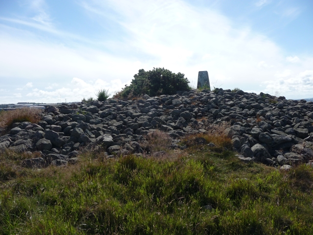
The Baron’s cairn can be seen in east from both of the Cat Cairns so follow the undulating path for a 1/2 mile. Go thru a new steel gate and a path leads to the cairns summit on which a trig point is perched. The much robbed cairn still stands at 19 meters wide and is some 1.3 meters tall. It seems to have been tidied up a bit as saw no fence or bricks that canmore go on about.
Industrial estates are very close, in fact immediately next door. The large brand new fence topped with razor wire making the place seem like a prisoner of war camp. Good views tho.
Visited 13/07/2010.

In front of the distant skyscrapers is Pitoddrie Stadium home to Aberdeen Football Club. (poor side, very poor side..........)
Image credit: drew/amj


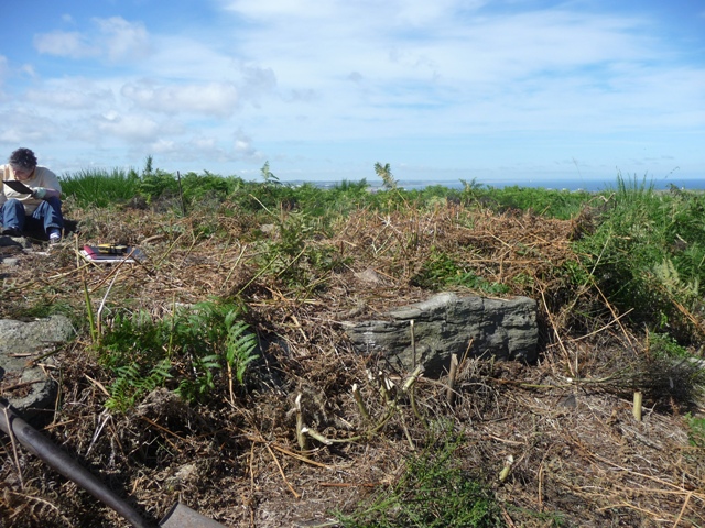
Some 60 meters in a north east direction from the Cat cairn, follow the path, my luck was in. A kerb cairn had been found and an archaeological team led by Ian Suddaby, of CFA Archaeology was busy uncovering the the newish site.
Ian explained that the site had been discovered in 2004 and Aberdeenshire Council had given the go ahead to excavate the Neolithic site. (The council acting wisely..........) The cairn itself is some 8.3 meters wide and at its tallest is possibly a meter high. Two very large kerbs can be seen to the south east and these seem to continue their way round. This part of the site is still to be uncovered so another visit will be required. The western side is excavated but here the kerb seems to have gone. Also the centre of the cairn has been slightly robbed.
Thanks to Ian Suddaby and his team. Hopefully when they have finished I’ll get a copy of their discoveries and I’ll post them as a link.
Visited 13/07/2010.


Like Fitz I worked in and around Aberdeen for various oil companies. But today was finally the day for the Tullos Hill stravaig.
Moving onto Hareness Road at the roundabout on the A956 I parked near the caravan site on Altens Farm Road. Immediately north of the caravans is a path. Ten minutes later and site can be seen. Basically it is still the same as Fitz describes. I will wax lyrical, since I come from here. There are fantastic views all around. Just a shame some of it is industrial.
Plus I’m going to add a new site. Something very good happened on the way to the Baron’s cairn.
Visited 13/07/2010.


An elderly lady who originally comes from Alford, but now lives in Turriff, told me about this stone. Many years ago her grandfather (along with her) would go for long Sunday afternnoon walks via The Auld Kirk (ring cairn), Gallow Hill (standing stone), North Strone (RSC) and a standing stone at Baldyvin. They must have been fit but its a nice walk which I’ve done a couple of times except for Baldyvin. So with a spare hour and being in the area I went to have a ‘ganner’.
Head east from Alford on the A944 taking the first minor road north. This road will also turn east sharply but head straight on to the farm track. Stop at the first gate on the west. Plenty room to park. From here walk dead straight west and the stone lies on the other side of a high fence. No fears a gate is nearby so access is ok. The stone originally stood in the middle of the field I walked across. It probably was aligned to Bennachie, north east. There are tremendous views of that hill in this area. The stone would have stood at 2 meters high.
It also seems to me that Canmore describe the wrong stone, this stone is a few meters to the north of the stone they mention.
Cheers Marianne.
Visited 11/07/2010.


