All the details from the before and after the house exstension. Pity, this must have been some place in it’s day.
drewbhoy
Buchaam is on the A97 south west of Glenkindie but befor the croosing of the Don. Head up the signposted track and go to the farmhouse to ask permission. This souterrain is in the garden.
Mr Ogg who runs the farm took time out from doing paperwork to give a history lesson. In 1895 the house was extended at both ends which led to the souterrain being terribly damaged. However they repaired it as best they could. In later years he asked permission to block the entrance as his children would have been endangered. The end nearest the house he covered until the children were well into their teens. I’ll stick up the Canmore notes which gives a fuller account.
To get into the souterrain is simple enough if you fancy crawling in on your stomach. Still, an excellent start to the day.
7/4/2011.


Councillor says hope still remains that the attraction could survive with new investment.
More info :

From Tuach Hill, the cairn is the bump in the top left hand side.
Image credit: drew/amj

The cairn is the black in front of the white warehouse. From Tuach Circle.
Image credit: drew/amj


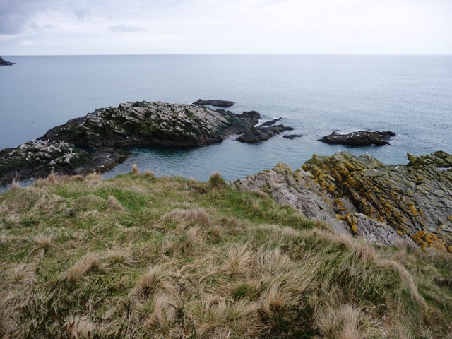
I drove thru Portlethen, past the police station and church pulling in at the Mains Of Portlethen farm. (note where I parked) From here walk to the track on the severe corner and follow the path to its end, turn south and the path leads straight to the fort. (no fences!)
A narrow passage leads to the fort which has a natural harbour to the north and a dangerous inlet to the south. The cliffs are of course very dangerous so watch your feet. Massive earthworks protect the fort from the land side. Like Gladman found at Garn Gawr so I found here, a gun emplacement was here during the 2nd World War, the military had been in action. The earthworks have been split in two to form a walkway. Two concrete slabs allow the walker to cross.
So all in all a very nice place. On the way back to the car wasn’t so nice. Waiting at the gate to the track a farmer stood and waited for my return. His language used I won’t replicate here but to say he was annoyed was an understatement. After giving my ears a severe pounding for 15 minutes, he was astounded to see me walk past the car in question. I kept walking and he stood amazed having built up a good rage for nothing. The guilty person was just walking past my car with her dog. With a wee word of warning I left the scene. To be fair the farmer was right as her car blocked two gates. Good fun!
29/3/2011.


The last perch of land and looking up. (to scared to look down!)
Image credit: drew/amj


From the cliff edge, note the height of the earthworks.
Image credit: drew/amj


Leave Aberdeen by going south on the A90 and take the second minor road west. Stop just after the first farm track heading the south. Looking the same direction a mobile telephone mast can be seen. The cairn is a 100 meters approximately to the north.
This would have been in the middle of a cairnfield but many have been removed thanks to agriculture and communications. The cairn itself has been damaged by similar if older methods. It had been used as a base to a tower, which was destroyed, and now houses a direction aid (which gives all the local places, somewhat ironic as that was the reason it was built presumeably to have these views). A small flight of steps leads to the top.
From the cairn there are tremendous especially north as Aberdeen and it’s bay are clearly in view. Portlethen is to the east. Inland the Highlands can be seen along with a lot of rural Aberdeenshire. It stands at 8.5 meters wide and 1.3 meters high with added bits of cement. I would the imagine the cairn will still survive whilst a lot of the stuff around it e.g. the phone tower will vanish.
Visited 29/3/2011.


The cairn which once had a tower but now has a sundial on top of it.
Image credit: drew/amj
Just to the north of Hatton Of Fintray and opposite the old church a tarred road leads to Home Farm. Stop about 1/4 mile and look north/uphill. This is a steady climb of another 1/4 mile to another cairn with views of Bennachie and the River Don.
This cairn has been battered, how it survives is nothing short of a miracle. It must have been massive. At one time it was used for beacon fires and now it houses a shed and another structure that shows some cairn material. Trenches showing robbery remain as well. Now it stands at some 24 meters wide and 1.8 meters tall seemingly defying all that was set against it.
Proudly it still stands despite the ages, hopefully it will remain a very long time yet. It’s defiance incredible!
Visited 29/3/2011.


This is a very easy cairn to find and one that I’ve been to many times. The cairn at one time was over 25 meters in diameter but now is held within a dry stane dyke over a meter in height. It has been recycled as a War Memorial for the First World War and now stands at 17 meters wide and has a height of over 2 meters.
I’ve been here many times as part of my duties as a musician/cornettist is to play the Last Post and Revielle on Armistice Day, this being one of the places I sometimes play. I never realised this was a cairn until Patrick Will, in one of his rambling but informative stories (this old man of Ythan is a living history book) said to find info about Donald’s Hillock, as usual he was right.
It is just south of the village of Hatton Of Fintray, a fitting monument to the ancients and those who went away and never came back during the terrible times of the First World War. Ancient and modern have joined together to enjoy truly wonderful views of the River Don and Tyrebagger Hill. Hopefully the villagers will continue to look after this very historic site.
Visited 29/3/2011.

Looking back north to the village of Hatton Of fintray.
Image credit: drew/amj


Archaeolink needs an investment of up to £2 million to save it from closure, says board of trustees.
More info :
A long time ago, according to Fred Coles, a large standing stone also stood here but unfortunately that has gone along with the cist and several urns. It is 13 meters wide and 0.8 high proudly looking down into the Deveron valley. This area is cairn central and quite a lot survive despite agriculture. Sadly tho, Denhead Wood has been used as a bit of a rubbish tip, various old machinery, plastic bags, concrete. (some of which has made it onto the cairn.)
Fortunately the present farmer, Hamish Slater, is quite proud of the cairn on his land and has had some of the rubbish taken away.
Carlinkist looks down on the River Deveron and the Turriff to Dunlugas/Eden minor road. Leave Turriff on the B9025 Aberchirder (Foggie) road and turn north just before the Deveron Bridge. Pull in at Boghead Farm and follow the track east up the hill to the clump of trees. The cairn is situated on the southern side.
Visited 27/3/2011.


Looking North East towards King Edward and 6 other cairns.
Image credit: drew/amj