
drewbhoy
Opposite Glenkindie House (home to a magnificent souterrain) on the A97 take the road south over the River Don signposted Culquoich. This road is very short and I parked at it’s end.
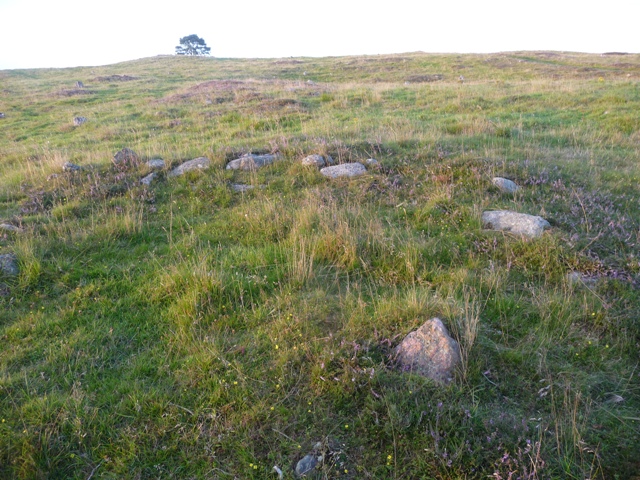
With all sorts of padding and strapping protecting the dodgy left leg I plodded up the slopes of Clachcurr, basically follow the track up and south until it ends at the deer gates. A short distance on and the cairn can be spotted next to track on the western side.
This cairn was well placed as Morven and Tap O Noth can be seen as well as spectacular views of the River Don and Deskry Water. One thing that astonished me was the distance the A97 heads west before it turns south towards Dinnet. I’d walked over the hill whilst on the road from Glenkindie to Bluemill must be at least 10 miles.
At 24 meters wide this cairn was obviously massive and a few kerbs remain sprinkled around the outer edges. Canmore say 0.6 meters high, I’d have said, with the casual eye, at least 1 meter.Some larger boulders and smaller cairn material can be seen in the cairns interior.
With that it was time to conquer Clachcarr. At the peak there is a walker’s cairn, more surprisingly is the remnants of a piano, strange but true. My next stop was Cairnbeg, a tortuous climb down proved the leg was back working properly and an indicator that the padding is indeed a good idea for the ankles.
8/9/2011.


Looking west, the summit of Clachcarr is beyond the trees.
Image credit: drew/amj


A hoard of gold Iron Age torcs found near Stirling is among the highlights of the sixth annual Scottish Treasure Trove report.
More info :


From Aboyne take the B968 over the River Dee (past The Boat Inn, excellent pub!!!) and turn east on the B976 until the Bridge Of Ess on a very sharp corner. I parked at the tower near the bridge and walked east along the minor road. Many years ago when wee boys my brother and I along with our dad and his pal Dod Coville often walked these paths. Dod was the factor at the Glentanar Estate so these roads brought long forgotten memories back. Fortunately the stunning scenery is still stunning with hardly any development of any kind.
A couple of miles further west is a welcome addition, the Braeleoine Visitor Centre. Went in to have a look and was quite impressed tho the assistant didn’t have a clue about cairns. From here head up the hill on the tarred road until it ends, this is pretty steep going. Move onto the track at the gateposts going past the sign to Belrorie until a crossroads is reached. From here head west until the cottage at Hillhead. The cairn is north of Hillhead but I headed slightly further west, jumped the gate, and followed the fence line, jumping a burn at the back of Hillhead. This takes you to the edge of the forest, simply follow the fence (don’t touch electric, a new high jump record has now been set in these parts) and you’ll walk straight to the cairn.
This cairn has tremendous views especially over to Morven with Loch Kinord sparkling in front. South is the Glentanar estate, aboyne east and Ballater west. Although the cairn has been excavated the centre is still intact and sits at 15 meters wide, 2 meters high, no kerbs remain. Maybe there hadn’t been any in the first place. Other cairns nearby have long gone, however some of the walls mentioned in Canmore remain. A wonderful place and a wonderful walk, Deeside is a treasure trove of sites.
Visited 11/08/2011.
At Crathie go onto the South Deeside, the B976, past the entance to Balmoral Castle and head back east until Mains Of Abergeldie, just after the first minor road heading south. I parked here and walked on to track opposite the farm. There is a crossroads of tracks, head west and keep going west onto the grass track, the stone is slightly to the south up a small hill.
To the north is Abergeldie Castle and the River Dee. This well shaped stone must have had good views which are now blocked by the trees. Still a pretty place tho.
Visited 11/08/2011.


The standing stone at St Maire’s burial ground has obviously lasted much longer than the chapel that also stood here. All that is a left on the knoll is an enclosure shaped place with the remnants of a dry stane dyke. It has stunning views of the Dee valley west and east, being surrounded by the Grampians. Yesterday this road was under several feet of water as the road was closed due to the Dee bursting it’s banks.
It has an upside down boot shape and is 1.4 meters tall. Head west from Ballater on the A93 (Royal Deeside road), past the Coilacreich pub and park at entrance to Lebhal farm, plenty of room. The standing stone is about 300 meters back east up a small slope on the north side of the road. Jump the small stream, torrent today, and your there. This place reeks history.
On the hill on the other side of the Dee, to the south west Creag nam Ban, the last witch on Deeside was burnt. (cheers Thelonius) The standing stone at St Manire’s would have made a gruesome vantage point.
Visited 11/08/2011.


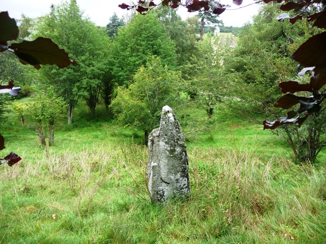

‘The church or chapel of St Manires (or Chapel Majore, according to Alexander), who flourished in the 6th century, stood in a knoll between Lebhal and Rhynabaich, surrounded by a burial ground used within living memory for unbaptised children. There is a (probably) a prehistoric standing stone which McConnachie says was used as a reading desk for the chapel and was said to be the remains of a stone circle. Keith writing in 1732, mentions ‘The Chappel of Hermitesas Miacras or Micras’ as being extant.
McConnachie 1898, Alexander 1952, Spalding Club 1847-69.


Top of the monument to St Manire’s burial ground/chapel looking on to the standing stone.
Image credit: drew/amj

A93 below, west Braemar, east Ballater and Coilacriech pub. (Cheers Col!!!)
Image credit: drew/amj


New find, 11 cup marks near the River Ythan at Methlick (which supplied the water).
Torrential downpour chased me back undercover but plenty more to look at another day.
Visited 6/08/2011.


The last stop of a very long day, I’d planned to do walk to another 2 cairns but time and nature combined to make this the end of the second Mearns day.
The Philla Cairn is shaped like a ‘flying saucer’ in that it is built on two levels. First a platform was built, some 20 meters wide, then a cairn built on top of that, some 12 meters wide. At it’s highest point it is over 1.5 meters in height. To the south west a large flat stone can be found, might be the remains of a cist. Some damage has been done but this shows us the construction work. Recently the gorse, jabby things etc have been removed but the cairn is very overgrown. The local farmer at Haremuir improved things greatly by moving the piles of dead vegetation further away. (He also, with permission, intends to try and tidy up the site, so re-visit at some point coming up. Plus a visit from me to visit other cairns, lucky chap!)
Once again this cairn has stunning views of the Mearns countryside. I’d intended to walk on to Kenshot but it was getting dark, so it can wait till the next time.
Visited 3/08/2011.


From the top of the cairn looking north. The gap in the trees is the track.
Image credit: drew/amj


