
The picture taken by Mr Hogan, where has he gone (his fieldnotes, tho long, were always informative and brilliant) is of a pile of field clearence near the radar station. The long cairn is on the other side of the road. His mistake can be forgiven as Canmore admit to making a mistake and originally thought the site an enclosure.
All that is left is basically the shell of the cairn which I estimated with the casual eye to be around 40 meters long, 20 meters wide northern end, 10 meters wide southern end. The height at the northern end would be about 1.5 meters whilst at the other end 0.5. One or two bits of cairn material remain with possibly a couple of kerbs. It must have been an impressive site and it has truly magnificent views. I’m beginning to love the Mearns, it is full of interesting stuff with loads more to visit.
Sweetcheat’s sheep were all well behaved. Leave the A90 just north east of the RAC monument taking the first minor road south east stopping at Ferniebrae farm, plenty room to park. Opposite there is a dead straight road going up Bruxie Hill, radars and things to left, long cairn to the right. Lots of cattle grills and gates so keep the farmer happy and keep them closed.
Visited 3/08/2011.

From half way up the hill. A lone AFC fan contemplates.


Cothillock when you see it on the OS or Phillips maps appears to an easy cairn, near the road in a small wood. Nae probs, says me.
Heading east after Arthurhouse on the B967 stop after the Lewis Grassic Gibbon centre at the road end to Pitcharles. The cairn is in the small wood. For me it took ages to find, up and down I looked, crawled and jumped until eventually I flung myself thru a gap in the trees to land on the cairn edge. If I’d approached from the south there is a gap but I didn’t spy it, handy for getting out tho.
The cairn is 14 meters wide and just over a meter high. There is damage to the edges with eastern side jumping down at least 3 meters. One or two bits of cairn material can be seen amongst the turf. It is well protected and hidden by the trees. Still if the mist had been here, like at Montgoldrum, it would have been ‘well scary’.
Visited 3/08/2011.
For this visit I went past Millplough and up to Cluseburn, parking at the end of the track. On the nearby hill is supposed to some cairns but they, sadly, seem to have vanished. It was clear at this time, on the way back it certainly wasn’t. So I decided to head cross country in a north east direction to Montgoldrum Cairn, something I’d missed the previous week. Cluseburn has water, not to deep as I discovered by mistiming my jump to land in but not over. Fortunately not as much water as my recent Loch Of The Clans adventures. So on I went over several fences and gates until I flukily walked straight into the cairn.
At one time this cairn had been protected by a fence but it appeared to an ancient relic as well going by it’s condition. As for the cairn, it is some 16 meters wide and 1 meter tall. For some reason it reminded me of the Trancie cairn, bowled out with ditch, minus the ditch. Damage to the cairn shows the constuction of earth and boulders. From the there it was up the hill, behind the wood to the east, to visit the RSC again (I like that place).
The way back was a bit of a nightmare as the sea mist had come in, visibility was poor and it was freezing. However a change of boots and socks lifted spirits as indeed did a visit to the Bervie chipper.
Visited 3/08/2011.


By the time I got back to the car it would have been lucky to see 50 yards in front.


This place I’ve wanted to visit for a long long time. So yesterday provided the chance and I took it. The cairn is 46 meters in length. At the North East end it is 14 meters wide and 1.7 meters high by the time it reaches the South West it is only 8 meters wide and 1 meter tall. It has been extensively robbed for it’s materials. Large rocks can still be felt underfoot as the cairn is mostly covered in turf and grass. The stunning thing about this place is it’s location. To north Gourdon/Inverbervie and their bays, to the south Point Of Bard (Haugh Bay). At times the view was superb then a north sea mist rolled in, the temperature dropped and the atmosphere became very eerie. So back down the hill I went.
The best access to this site is by the following route. South on the A92, thru Inverbervie, past Gourdon and take the first track heading west. This leads up a very steep hill. Keep going until the first crossroads and take the road heading north east. Keep going towards the crest of the hill, the cairn is in the field to east with tremendous views in all directions. Great place.
Visited 3/08/2011.
The Cairn of Arthurhouse is set in the tranquil woods overlooking the Bridge Of Kair underneath flows the Bervie Water. Supposedly massive at some stage it remains an excellent site being 21 by 19 meters in length/width and 3.5 meters tall. The north side has been partially dug away and a small pit remains on top of the cairn. But the setting is wonderful, the Mearns countryside once again breathtaking.
Easiest directions, road wise. Leave the A90 at Fordoun and head east. Turn onto the Waterlair track, south, just before the Bridge Of Kair. From here I walked thru a field to a wood up the hill to the south. Keep heading south until the wood narrows then widens again. In a large clearing the cairn sits proudly in the middle.
Visited 3/08/2011.


Along the top of the barrow, the pea souper coming closer.


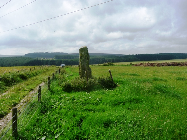
What a wonderful standing stone to start the day with complete with Ogham markings. This is a very fine example. Great all round views especially over to Raedykes home to several sites.
Take The Slug (A957 Banchory road) and leave at the first minor road heading north. Take the first left and stop at the first track heading east after Nether Auquhollie. The stone is only a short walk up the track, with a step in fence to help get a closer inspection. Locally this stone is far better known as The Lang Stane.
Visited 3/08/2011.


Towards the long suffering drewmobile.

Fantastically shaped stone looking south.


Binn Hill is a hard cairn to find due to the summer foliage but three kerbs on the western side make it findable. The difference in height of the ferns is a give away as well. It stands at over 10 meters wide and is a meter in height. Two other stones mentioned by Canmore are there, these probably being removed kerbs, most likely when the cairn was opened. Why didn’t they not put them back?
Best way to here is to visit Innesmill (Standing Stones Of Urquhart tho nobody up here calls it by that name) then head north east on the road till it ends. Keep going a short distance east and pull into forestry track after Ferniefield to the north. Take the track west for about 1/2 mile, the main track heads north, keep going west on the smaller until the second wee path north. This leads to the top of hill, head west and look for a bump near a couple of boulders, if you see three boulder kerbs on the west side you’ve made it.
Visited 28/07/2011.


