
Buchromb stands on the hill of the same with good all round views. Unfortunately it has taken a battering with an enclosure or something similar being cut into it. Still kerbs remain on the northern side and it still is almost 27 meters in diameter plus 1.5 meters high. Canmore reckon the damage done is deep enough to have reached any internal structures.
However the missing kerbs might not to be to far away as a field clearence pile is 60 meters to the west. It is made up of small stones, slates and bigger stones that look like they belong somewhere else. There are other small piles dotted around.
I met two people on my way to the cairn, one who didn’t know it was there (unbelievable) and farmer who went on about getting grants for putting up a fence around it. There is a fence, in worse condition than the cairn, but it is in severe need of restoration. I offered to repair the fence there and then but received a negative response.
From Dufftown head north west towards Craigellachie on the A941 turning east at the second of two entrances to Buchromb. Keep going until the cottages. The cairn is on top of the hill behind, follow the track till it’s end then head east at the pile of field clearence.
Visited 14/10/2011.
A small knoll partly destroyed in the flood of 1829, called Lord Auchindown’s cairn, marks the spot where Sir Patrick Gordon of Auchindoun is said to have died after the battle of Glenlivet in 1594.
NSA 1845.
Site details and a mention of agriculture. Nice aerial pic.
This uncompleted fort must have been a massive place as it measures 600ft by almost 500 ft. Two lines of stone ramparts surround the top of the hill except on the northern side where ditches seem to take over. It seems that stone defences were never finished. The views to Dufftown are stunning, Tap O Noth can be seen to the east, Durn Hill in the far north with Ben Rinnes to the south and to the west, The Highlands. So massive was the fort that some agricultural uses have been recorded.
There must be an easier route than my one as there is a path of sorts at the top which seemed to go north towards Dufftown. I stopped at the second farm track heading west south of Dufftown on the B9009. From here walk the track thru nice woodland, past a quarry, some ruined farmsteads until the tracks end at the 7th hole of the local golf course. Seeing golfers prepare to drive up the hill, I waited, only to see balls come over my head from behind me. Obviously the 7th is uphill. Over the back of the green into the woods and head straight up jumping over a couple of burns. This is very steep in parts and if an easier route can be found use it. Still the views are astonishing, I’ve never been here before and to see Tap O Noth just appearing over the hills in the east is magical. Ben Rinnes, which I’ve climbed several times, looked majestic, and very shapely. As is usual going back downhill is easier, and this time I was ready for the 7th hole.
Visited 14/10/2011,
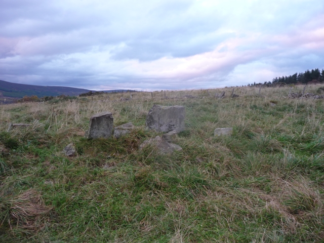
They say this is a very small stone circle and they are correct. They also say it might be a RSC, if it is it is the smallest recumbent I’ve ever seen. Two slab like flankers are at both sides of a small slab which is the possible recumbent. Several stones presumably from the circle lay at the sides. What looks like a possible cist also sits amongst the stones.
The ‘flankers’ are about 3 feet tall and recumbent 1 foot tall. The widths are in centimetres no more than 20 of them. Still the debate about this place will go on, Adam Welfare mentions it in his book as well.
Situated almost in the Glenlivet valley the views of the mountains are superb. This place has an atmosphere tho, it feels old, really old.
Follow the signpost at Glenlivet to Tomintoul, the B9136 taking the second minor road south just after Glenlivet Health Centre. Head south and take the first farm track to the west signposted Nethertown. Park at the farmhouse, I asked permission, and was also given direction by the farmer. Walk up past the barns, over the gate, past a dung midden then its the circle. Today it didn’t smell to bad and the cows posed quite happily for foties.
Visited 14/10/2011.
This is a splendid cairn with several kerbs surviving on the western side. On the negative side the area has been reforested with the cairn being left in a clearing. So how easy a place to find in the future is guess work.
The cairn, which sits in the glorious Spey side valley, is some 10.5 meters wide and over 1 meter in height. I don’t know if kerbs have outliers but one stone certainly looks like one. Some cairn material pokes thru the turf.
From the A95, take the B9138 west and be careful at the bridge crossing the River Spey. Take the B9102 north and pull in near the Mains Of Kirdells. The cairn is to west of road. Climb a gate, jump a burn and walk to the brow of the hill.
Visited 14/10/2011.
The fence here is in far better condition than it’s near neighbour as Auchorachan.Take the B9136 turning south near the primary school. As the road heads directly south stop at the first gate on the east. The stone is about 50 meters from the road. This beautifully sited monument has wonderful all round views. About 200 meters down the road is the famous distillery at Glenlivet. Lovely place!!!
Visited 14/10/2011.
Go south from Dufftown on the B9009 until Auchbreck. From Auchbreck head south on the B9008, going past Auchorachan farm pull into the east side of the road at the first gate after the farm. The stone, standing on the brow of the hill at 1.7 meters in height, has lovely views south, north and west. Packing stones can be seen at the base of the stone.
The lovely sight of Glenlivet distillery is on the other side of the valley. Sadly the fence has seen better days on the plus side no cows dropped dead during the visit!
Visited 14/10/2011.


Miles into east directly behind the trig is Tap O Noth.


Looking west along the higher rampart towards Ben Rinnes.

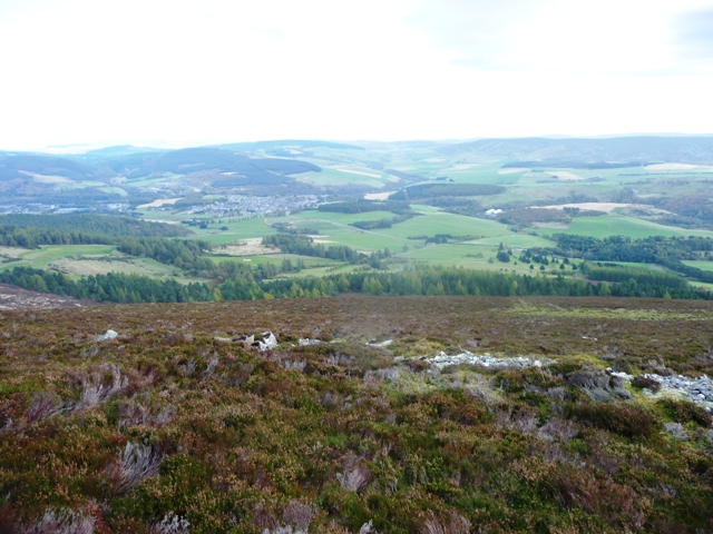


Looking south, ah a distillery. Boost!! And a dung midden, not such a boost.


Canmore quite rightly hedge their bets and say this might possibly be a kerb cairn then again it might be a ruined stone circle set on the eastern slopes. There are certainly stones that look like they once stood and there are certainly some kerbs plus loads of cairn material. Sadly it has also received some harsh treatment. However its position keeps alive some of the former glories. Views east and west are of the Don valley, to the south Culquoich and to the north the modern cairn on the summit of Dalrossach. There are some cracking rocks for cup marks etc, I couldn’t find any unfortunately.
I parked at Dalrossach west of Glenkidie on the A97. Opposite the farm entrance is a track that winds up the hill. Fairly steep all the way to the cairn but worth it for the views. Looking for the other cairn I accidentally climbed the hill to the north. Looking all round I discovered that I’d climbed every hill in the area and still there is much to find in what is my favourite hill walking area.
Visited 13/10/2011.


