
Crickley Hill and neighbouring sites, seen from Cooper’s Hill Wood to the SW.
Image credit: A. Brookes (20.4.2013)
Crickley Hill and neighbouring sites, seen from Cooper’s Hill Wood to the SW.

The southern end of the rampart, much reduced. Looking north.

The most substantial section of earthwork, at the northern end of the single rampart.

A very fine barrow in need of a bit of tidying.


The excellent SW barrow, slowly disappearing under vegetation.

Birdlip Camp (centre) seen from nearby Crickley Hill fort.

The impressive eastern rampart, looking north.

Looking SW from the ramparts across Witcombe Reservoirs to Cooper’s Hill, with High Brotheridge Camp rising slightly higher beyond.

Not the easiest thing to photograph, but the circular feature in the foreground is probably the most enigmatic aspect of the site (see fieldnotes). Churchdown Hill can be seen in the middle distance.

The very steep southern scarp face, looking across to Barrow Wake.

The northwestern aspect of the fort, where the natural scarp does much of the defensive work. Crippetts long barrow is hidden behind the tree line on the right skyline.


The northern rampart ends abruptly at the quarry face.

The northern rampart, hitherto very overgrown and difficult to access.


The eastern earthwork, extending away from the fort.

Hillforts of the north Cotswolds, seen across Cheltenham from Hartley Hill on a rather hazy day. Battledown is indicated but is not a certain prehistoric site.

Looking across the top of the mound (more exposed stone) towards Cleeve Hill and Dowdeswell Wood.

Some of the freshly exposed limestone blocks on the mound.

Looking north. Various bits of exposed limestone can be seen on the mound.

After a rather up and down walk along the face of the escarpment, it’s something of a relief to reach the trees that mark the promontory fort, where I’m greeted by the rat-a-tat of a woodpecker looking for lunch. The Cotswold Way enters the wood at the single rampart, which is at its most impressive at this northern end. It has been damaged by quarrying; there’s a big pit across the path outside the camp. Aside from this feature, there is little visible to indicate the presence of Iron Age occupation. The interior is covered in trees, albeit a light deciduous wood that allows plenty of visibility through the site.
The ground falls away very steeply on the north and south sides – my path runs to the end of the promontory and then back along the opposite side. Reaching the southern end of the rampart, there is hardly anything left of the earthwork here. It’s a pleasant spot on a sunny day, but don’t expect to be blown away by the visible remains.
Like nearby Crickley Hill, my last visit here was in a worsening snow fall. The contrast couldn’t be more extreme today, coming to the barrows in lovely spring sunshine, every footfall releasing the scent of wild garlic.
The disadvantage of a spring visit, even after such a late winter, is that the barrows are quite overgrown and much of the vegetation is of the brambly kind, trying to trip me up and making even a walk around the two barrows quite a challenge. Don’t bother coming in high summer! Actually the barrows repay the effort, the larger of the two is as fine an example of a sizeable Bronze Age burial mound as you will find in these parts.
My last visit to this fine site was in falling snow and a black and white world. Not so today. The walk through the woods of Crickley Hill Country Park to the northeast is lovely, sun streaming down. I stop at the Visitor Centre briefly, it’s usually been closed when I’ve been here before and it’s worth a look to see the information boards, together with some prehistoric finds and a model reconstruction of the site.
The site itself is quite magnificent, probably the best hillfort encountered so far along the Cotswold Way as, unlike Cleeve Cloud and Leckhampton Hill, it hasn’t been so badly damaged by quarrying (although it hasn’t entirely escaped). The Way passes through the impressive Iron Age ramparts that cut off a large wedge-shaped promontory. Inside this, various hut circles are marked out by concrete posts, although there’s nothing else remaining of them. The main features of the view today are Robinswood Hill and Churchdown Hill, two conical outlier of the Cotswold escarpment. The Malverns are but dimly seen through a haze more reminiscent of summer.
The most enigmatic part of the site is the circular feature at the northern end of the Neolithic earthwork, although little remains of it now. The circle, 8 metres across, was enclosed by stones and had a central hearth. “Ritual” purposes abounded, no doubt. From the western tip of the promontory, my route ahead comes into view for the first time, Barrow Wake across the steep-sided valley that now houses the A417, with Birdlip Camp, Witcombe Wood and Cooper’s Hill beyond. The Mother River, the Severn/Hafren, lies broad and glinting to the southwest.
It’s busy here today, as you’d expect on such a lovely day, and before long the impulse that pushes me onwards, away from the crowds, comes back. The Cotswold Way turns back along the southern edge of the promontory, where the ground falls away most steeply, before leaving the fort into yet another delightful beech wood.
Coming from the east (unusually for me), old quarrying scars blight the first approaches to Leckhampton Hill, but the views over the escarpment are particularly fine, despite the haze today. After a couple of bridle gates, the path eventually comes to some rather enigmatic earthworks stretching away from the fort, their overall layout and purpose not really clear. Following the path onwards, it soon reaches the northern section of the ramparts proper. This is the best-preserved part of the defences, and a walk to the northern tip offers a terrific aerial viewpoint off the near-vertical quarried cliffs and across Cheltenham. I can indeed see my house from here (well, my street anyway). Although I’ve been up here many times now, there is always something new to see. In this case, it’s the northern rampart, below the lip of the escarpment, much more clear of vegetation than I have seen before.
I sit up here for a while, perched high above home and contemplate my choices. I had intended a short walk after the North Wales efforts earlier in the week, but the day is still young and the sunshine is calling me onwards. Besides which, this is one of those parts of the route where ending here would require an otherwise unnecessary climb at the start of the next walk. I decide to press on, at least as far as Crippetts.
Leaving the fort, I head down to one of the many quarries hacked into the hillside, this one serving as a carpark now. I hunt around unsuccessfully for fossils, but to my astonishment, tucked into a crevice in the limestone, I find a pile of chalk-covered flint nodules, some quite large. Nothing worked that I can see, but I have always thought that flint was alien to this part of the Cotswolds, any flint tools being imports from the eastern downs (or further afield). Not so, it seems. Well, you live and learn.
Reaching a field at the edge of the wood, the worst of the climb over, I leave the Cotswold Way route along another footpath, heading southwest. From here the view opens up beautifully to the north, where Cleeve Hill fills the skyline, with Cheltenham spread out below to the northwest. The reason for my temporary diversion lies just over the crest ahead of me, in the next field.
Lineover long barrow has suffered greatly over the years. Now resembling an elongated round barrow, there is little to paint an obvious family resemblance to its near neighbours at Belas Knap or Crippetts. But pause a little longer – the positioning gives away its undoubted blood ties, perched below the highest point of the hill, but enjoying extensive views over the edge of the escarpment. Typical Cotswold-Severn long barrow location in fact. I’ve not been here for about 18 months, the grass is cropped shorter than on my previous visits. The barrow still stands to a height of over a metre and various large pieces of limestone can be seen resting here and there on the mound. There is no livestock in the field today, although the hardened prints around the field edge indicate that cows are still the usual occupants. The only real detraction from a visit remains the horribly busy A436, where I doubt many of the drivers ever notice the long barrow they pass in an eye-blink. The inevitable crump of shotguns can also be heard, far off. Still a worthwhile stop-off, an old friend to revisit, renew acquaintances and share some time together.

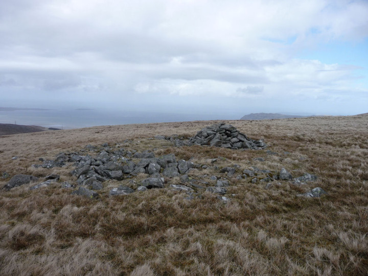
The modern marker cairn at the southern end of the summit ridge boasts terrific views of the Ogwen Valley. I can’t find anything to indicate that it is built from anything older, but there’s so much going on up here that I wouldn’t discount it either.

The southern cairn, looking SE towards Yr Elen and Carnedd Dafydd.

The less-knackered central cairn, looking north. The shoulder of Moel Wnion fills the right of the picture.

The knackered northern cairn, looking across to Ynys Mon.

Somewhat distant Moel Eilio seen from Bwlch ym Mhwll-le near Moel Faban in the Carneddau. The much-trashed cairn can just be seen as a pimple on top of the mountain.


Looking NE with Llefn and Gyrn looming above.

Fine little cairn with central cist.

Looking WSW towards Moel Faban, topped with obvious cairns.

Two adjoining circular structures, looking SE to Drosgl and Gyrn Wigau. The settlement is quite sheltered in the high-sided valley, despite being above 400m OD.

Detail of low remains of settlement walls, looking up to Gyrn.

Postie crossing one of the larger circular enclosures in the settlement. The western Glyderau (and Moel Eilio, right) provide the wonderful backdrop to the setting.

Low rubble remains of settlement walls. Looking SE to Gyrn Wigau.
Looking north out to sea (Ynys Mon and Puffin Island can just be seen far left horizon).

Moel y Ci is the dark hill in the centre of the picture. Seen from Bera Bach, looking over Gyrn Wigau. There is a prehistoric settlement in Cwm Caseg (left).

The be-cairned summit of Carnedd Dafydd, seen from Bera Bach. Someone will tell me if that’s the cairn on Garnedd Fach visible to the right?

Carnedd Llewelyn (left of centre), flanked by Foel Grach (far left), Yr Elen (right of centre) and Carnedd Dafydd (right). All but Yr Elen are topped with prehistoric cairns. The viewpoint is Bera Bach.

Some further landscape context for the settlement, from Bera Bach. Carnedd Dafydd is the snow-flecked mountain on the left, the western Glyderau centred on the elegant cone of Elidir Fawr provide the rest of the backdrop.

Drosgl from the summit tor of Bera Mawr.

Maes y Gaer (centre), seen from the summit of Bera Mawr.

Moel Wnion, illuminated, with becairned Cras to the right and Ynys Mon beyond. Seen from the rocky summit of Bera Mawr.

The kerbed cairn, looking north out to sea.